Browse Listings in Catch All
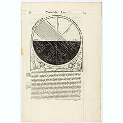
Page from La Cosmographie Universelle . . . (Page 34)
Text page with woodblock illustration showing a globe ( size 185 x 165 mm.) In 1575 Sebastian Münster's Cosmographia was translated into French and published in Paris by...
Date: Paris, 1575
Selling price: ????
Please login to see price!
Sold in 2021
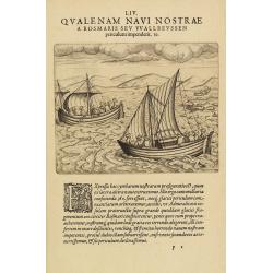
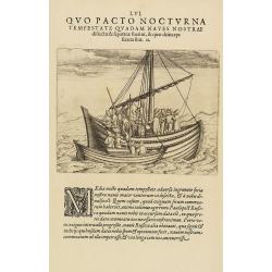
LIV Qualenam navi nostrae a rosmaris seu Wallreussen periculum impenderit 19. (The third Dutch artic voyage by W.Barentsz.)
These famous and desirable scene is engraved by de Bry depicting the two open ships during the return voyage during the third Dutch arctic voyage in order to find the nor...
Date: Frankfurt 1601
Selling price: ????
Please login to see price!
Sold in 2014
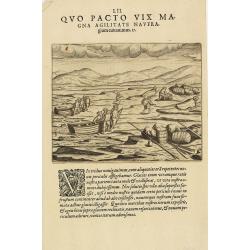
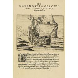
The third Dutch artic voyage by W.Barentsz.
This famous and desirable scene during the third Dutch arctic voyage in order to find the north-east passage to India.Barentsz made three voyages (1594, 1595, 1596-1597) ...
Date: Frankfurt, 1601
Selling price: ????
Please login to see price!
Sold in 2017
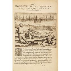
The third Dutch artic voyage by W.Barentsz.
This famous and desirable scene during the third Dutch arctic voyage to find the northeast passage to India.Barentsz made three voyages (1594, 1595, 1596-1597) searching ...
Date: Frankfurt, 1601
Selling price: ????
Please login to see price!
Sold in 2017
The third Dutch artic voyage by W.Barentsz.
This famous and desirable scene is depicting a scene during the third Dutch arctic voyage in order to find the north-east passage to India.Barentsz made three voyages (15...
Date: Frankfurt, 1601
Selling price: ????
Please login to see price!
Sold in 2010
The third Dutch artic voyage by W.Barentsz.
A desirable scene during the third Dutch arctic voyage in order to find the north-east passage to India.Barentsz made three voyages (1594, 1595, 1596-1597) in search of t...
Date: Frankfurt, 1601
Selling price: ????
Please login to see price!
Sold
The third Dutch artic voyage by W.Barentsz.
These famous and desirable scene is engraved by de Bry depicting a scene during the third Dutch arctic voyage in order to find the north-east passage to India.Despite the...
Date: Frankfurt, 1601
Selling price: ????
Please login to see price!
Sold in 2017
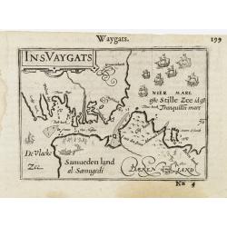
Ins. Vaygats.
An interesting miniature map of present day Ostrov Vaygach depicting the narrow strait between the island and "Samueden land". The sea is filled with sa...
Date: Amsterdam/Frankfurt, 1609
Selling price: ????
Please login to see price!
Sold in 2009
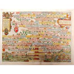
Saxones Anhaldini, Inclytiss et Illustriss
Double page from the family tree of Saxonia emperors from 1123 to 1605, decorated beautifully with coat of arms and three splendid cartouches. At the bottom of the tree i...
Date: Florence, 1612
Selling price: ????
Please login to see price!
Sold in 2013
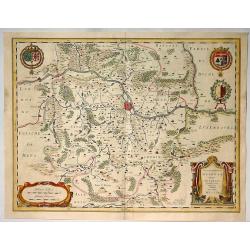
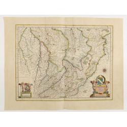
Territorium Metense.
A decorative example of Blaeu's map of the the Metz Region, centered on the city of Metz and the Moselle River. It is a lovely map focusing on the wine region in the Mose...
Date: Amsterdam, 1640
Selling price: ????
Please login to see price!
Sold in 2020
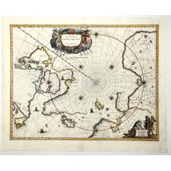
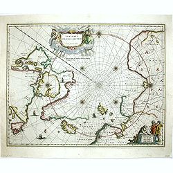
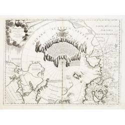
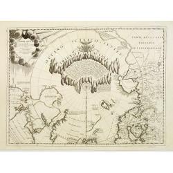
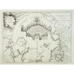
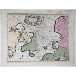
REGIONES SUB POLO ARCTICO.
One of the many cases of duplication by the firms of Blaeu and Hondius/Jansson. In this case, Blaeu has copied Jansson's map of 1637. It depicts rhumb lines radiating fro...
Date: Amsterdam, 1640
Selling price: ????
Please login to see price!
Sold in 2019
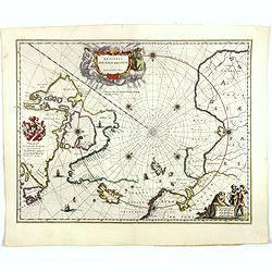
Regiones Sub Polo Arctico.
One of the many cases of duplication by the firms of Blaeu and Hondius/Jansson. In this case, Blaeu has copied Janssonius map of 1637. It depicts rhumb lines radiating fr...
Date: Amsterdam, 1644
Selling price: ????
Please login to see price!
Sold in 2017
Champagne latine Campania, comitatus.
A good engraved map embellished with decorative scale cartouches showing two putti with a globe.
Date: Amsterdam, 1645
Selling price: ????
Please login to see price!
Sold in 2020
Regiones Sub Polo Arctico.
North pole region. It depicts rhumb lines radiating from the North Pole. A large title cartouche, with two figures and numerous wind heads, conveniently hides the unknown...
Date: Amsterdam, 1647
Selling price: ????
Please login to see price!
Sold in 2013
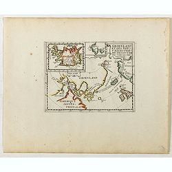
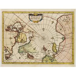
Groenland et les Nouvelles Terres Descouvertes Vers Le Septentrion.
Rare map of the Arctic regions, focusing on the recent discoveries in the region. Inset map of Iceland (62x84mm.) in upper left corner. The map was based on the informati...
Date: Paris, ca. 1648
Selling price: ????
Please login to see price!
Sold in 2019
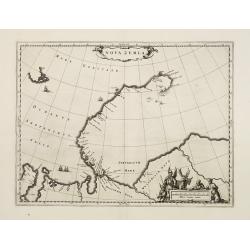
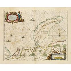
Nova Zemla
The Dutch were the most persistent searchers after the north-east Passage, whether to the north of Novaya Zemlya (whose west coast is shown in detail) or through what the...
Date: Amsterdam 1650
Selling price: ????
Please login to see price!
Sold
Nova Zemla..
The Dutch were the most persistent searchers after the north-east Passage, whether to the north of Novaya Zemlya (whose west coast is shown in detail) or through what the...
Date: Amsterdam 1650
Selling price: ????
Please login to see price!
Sold
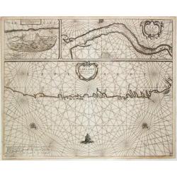
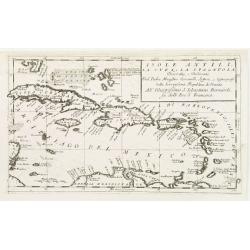
![[No title] I. de S.Iuan de Puerto rico?](/uploads/cache/23557-250x250.jpg)
[No title] I. de S.Iuan de Puerto rico?
Interesting chart of the Lesser Antilles, from Porto Rico as far as Trinidad & Tobago and the South American coast. North is orientated to the left of the page. One o...
Date: Amsterdam 1658
Selling price: ????
Please login to see price!
Sold in 2008
Fretum Nassovium vulgo de Straet Nassou.
Decorative map of the Nassau Strait, from the Atlas Major. Includes 2 compass roses, sailing ships, rhumb lines and 2 elaborate cartouches. Latin text below and on verso.
Date: Amsterdam 1660
Selling price: ????
Please login to see price!
Sold
Insulae Joannis Mayen cum universo situ Sinuum et Promontoriorum.
From the Atlas Major.
Date: Amsterdam 1660
Selling price: ????
Please login to see price!
Sold
Fretum Nassovium vulgo de Straet Nassou.
Decorative map of the Nassau Strait, from the Atlas Major. Includes 2 compass roses, sailing ship.
Date: Amsterdam, 1660
Selling price: ????
Please login to see price!
Sold in 2018
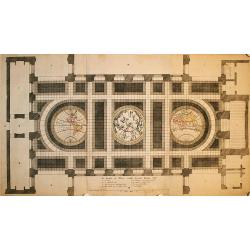
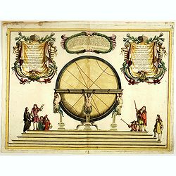
De Grondt en Vloer vande Groote Burger Sael
This unique sheet depicts three maps that were laid in the marble floor of Amsterdam Town Hall. At center is a celestial map of the northern sky with the Western and East...
Date: Amsterdam, 1661
Selling price: ????
Please login to see price!
Sold in 2009
![Itroductio. [with Compass rose.]](/uploads/cache/23701-250x250.jpg)
Itroductio. [with Compass rose.]
Introduction leaf from a French text edition of Atlas Major
Date: Amsterdam 1662
Selling price: ????
Please login to see price!
Sold in 2008
Regiones Sub Polo Arctico
Nice copy of Blaeu's North Pole map. Latin text on verso.
Date: Amsterdam, 1662
Selling price: ????
Please login to see price!
Sold in 2009
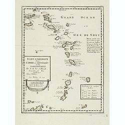
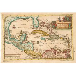
Isles d'Amerique dites Caribes ou Cannibales et de Barlovento. . .
Uncommon map of the Lesser Antilles from the Virgin Islands to Margarita Island off the coast of Venezuela. Navigational notes and a lettered key to European possessions ...
Date: Paris, 1664
Selling price: ????
Please login to see price!
Sold
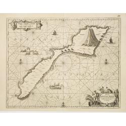
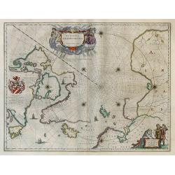
Insula que a Joanne Mayen nomen sortita est.
Splendid and scarce map of Jan Mayen Island. Jan Mayen is an isolated island in the northern Atlantic, lying between 70-72° North and 8-9° West, about 550 kilometers no...
Date: Amsterdam, 1667
Selling price: ????
Please login to see price!
Sold in 2018
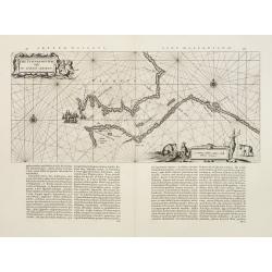
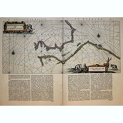
De Custen van Laplant tusschen de Rivier van Kola en de eylande van Swetenoes / het eylant Kilduyn met de rede / De Rivier van Kola in 't groot besteck.
Theunis Jacobsz, Amsterdam-based maritime publisher added Lootsman (pilot) to his name. After his death in 1650, his sons Jacob Theunisz and Casparus continued the firm. ...
Date: Amsterdam, 1676
Selling price: ????
Please login to see price!
Sold
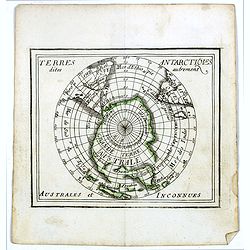
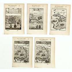
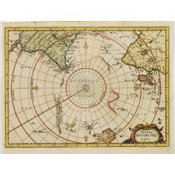
Terres Antarctiques .. Australes et Inconnues.
Uncommon miniature map of the South Pole, including Australia, New Zealand, southern tips of Africa and America. From Pierre Duval's La Geographie Universeille dated 1676...
Date: Paris, 1676
Selling price: ????
Please login to see price!
Sold in 2016
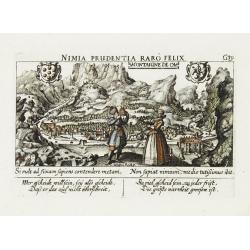
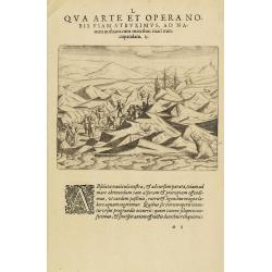
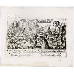
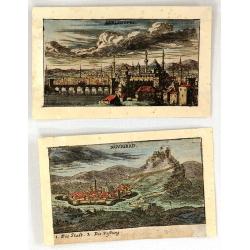
Montaigne de Ca.
A very nice view of a town in the mountains. In the foreground a couple of which the man is holding a quadrant. With a verse in two languages underneath the picture.The p...
Date: Frankfurt, 1623-1678
Selling price: ????
Please login to see price!
Sold
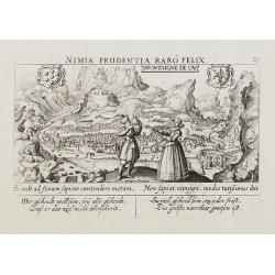
Montaigne de Ca.
A very nice view of a town in the mountains. In the foreground a couple of which the man is holding a quadrant. With a verse in German and Latin underneath the picture.
Date: Frankfurt, 1623-1678
Selling price: ????
Please login to see price!
Sold in 2010
Montaigne de Ca.
In the foreground a couple of which the man is holding a quadrant. With a verse in two languages underneath the picture.The poet and topographer from Comothau, Daniel Mei...
Date: Frankfurt, 1623-1678
Selling price: ????
Please login to see price!
Sold in 2016
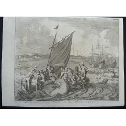
Walrus hunting at Nova Zembla 1596.
This is a fascinating copper engraving that depicts a battle between the crew of a small boat and a large walrus, with ships, polar bears, seals and whales in the backgro...
Date: Amsterdam, 1681
Selling price: ????
Please login to see price!
Sold in 2020
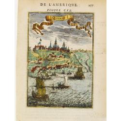
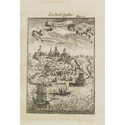
Quebec.
A charming late 17th century French view of Quebec.
Date: Paris 1683
Selling price: ????
Please login to see price!
Sold
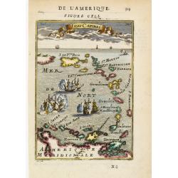
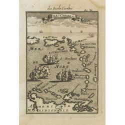
Isles Caribes.
Very handsome map of the Caribbean, extending to include the shores of South America. The map is inserted in a prospective view of the Caribbean Sea, where some vessels a...
Date: Paris 1683
Selling price: ????
Please login to see price!
Sold
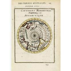
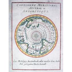
Continent Meridional Australe ou Antarctique.
A circular south-polar projection depicting the continents with partial coastlines for Antarctica, Australia and New Zealand. Includes the southern portions of Africa and...
Date: Paris 1683
Selling price: ????
Please login to see price!
Sold
Isles Caribes.
Very handsome map of the Caribbean, extending to include the shores of South America. The map is inserted in a prospective view of the Caribbean Sea, where some vessels a...
Date: Paris, 1683
Selling price: ????
Please login to see price!
Sold
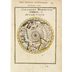
Continent Meridional Austral ou Antarctique.
A circular south-polar projection depicting the continents with partial coastlines for Antarctica, Australia and New Zealand. Includes the southern portions of Africa and...
Date: Paris, 1683
Selling price: ????
Please login to see price!
Sold
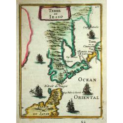
Terre de Jesso.
Alain Manneson Mallet (1603-1706) published in 1683 his ' Description de l' Univers' in 5 volumes. In 1686 a German edition appeared.An attractive little map of Japan fro...
Date: Paris, 1683
Selling price: ????
Please login to see price!
Sold in 2016

Zodiaque.
Attractive print showing a putti with sphere, surveying instruments, a world map in double hemisphere and California as an island.From the French text edition of Descript...
Date: Paris, 1683
Selling price: ????
Please login to see price!
Sold in 2014
(Five engravings of Caribbean interest from Description de l\'Univers)
Finely etched maps entitled : Le plan de l'Isle de St Jan de P.to Rico, Hispagonla et P. Rico, I. de cuba et de Jamaica, Isles Caraibes, Isles Caraibes". From the Fr...
Date: Paris, 1683
Selling price: ????
Please login to see price!
Sold in 2015
I. d'Horn.
A charming view of a bay at The Hoorn Islands (also Futuna Islands) , with a ship in the bay, with smaller vessels and natives along the shoreline. Title in curtain drape...
Date: Paris, 1683
Selling price: ????
Please login to see price!
Sold in 2020
I. Cocos.
A charming view of the Cocos or Keeling Islands, located near Australia. Title in curtain draped at top. French text on verso.From the original 1683 text edition of "...
Date: Paris, 1683
Selling price: ????
Please login to see price!
Sold in 2020
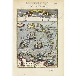
Isles Caribes.
A charming map of Caribbean islands, including Puerto Rico, Martinique, St. Christopher, and Aruba, among many others. Many small illustrations of ships in battle. Title ...
Date: Paris, 1683
Selling price: ????
Please login to see price!
Sold in 2020

Quebec.
A charming late 17th century French view of Quebec.From the German text edition published by Davis Zunners. Allain Manneson Mallet (1630-1706), a well travelled military ...
Date: Franckfurt, 1684
Selling price: ????
Please login to see price!
Sold in 2008
Isles Caribes.
Very handsome map of the Caribbean, extending to include the shores of South America. The map is inserted in a prospective view of the Caribbean Sea, where some vessels a...
Date: Frankfurt, 1684
Selling price: ????
Please login to see price!
Sold in 2008
Pas kaart van de Zuyd kust van Cuba en van Geheel Yamaica
Fine sea chart covering the southern part of Cuba, all of Jamaica and the western tip of Hispaniola and a bit of the Honduras coastline Insets of "Baya Oristan in Ya...
Date: Amsterdam, c.1684
Selling price: ????
Please login to see price!
Sold in 2010
Quebec.
A charming late 17th century town-view of Quebec.From the German text edition published by Davis Zunners. Allain Manneson Mallet (1630-1706), a well travelled military en...
Date: Franckfurt, 1684
Selling price: ????
Please login to see price!
Sold in 2012
Enirne, Turkey & Nograd, Hungary - Two Miniature City Plans
Two miniature copperplate city plans featuring Novigrad, Hungary and Adrianopel, Turkey.They are by Van Birken, published in Germany in 1684.
Date: Germany, 1684
Selling price: ????
Please login to see price!
Sold in 2016
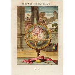
Globe Terestre.
Decorative print of a terrestrial globe. By Allain Manneson Mallet (1630-1706), a well traveled military engineer and geographer who worked in 17th century France under K...
Date: Paris, 1685
Selling price: ????
Please login to see price!
Sold in 2008
Continent Meridional Austral ou Antarctique
Early map of the southern Hemisphere, showing N. Hollande (Australia), N. Zelande, Terre de Diemens with incomplete coastlines according to the present knowledge. New Gui...
Date: Frankfurt 1686
Selling price: ????
Please login to see price!
Sold
Geometry, Arts & Science & Phisicks (3 engravings)
Three copper engraved prints from "The Gentleman's Recreation" by Richard Blome. They feature the ancient studies of geometry, physics & arts and science ea...
Date: London, 1686
Selling price: ????
Please login to see price!
Sold in 2013
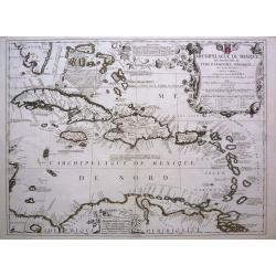
Archipelague du Mexique ou Sont les Isles de Cuba, Espagnole, Jamaique, etc avec les Isles Lucayes, et les Isles Caribes. . .
A superb decorative map of the West Indies originally done by Coronelli, later improved and revised by Tillemon for Nolin.The map provides alternate spellings of many Car...
Date: Paris, 1689
Selling price: ????
Please login to see price!
Sold in 2017
Illustrissimo, et Eccellentissimo.. Gran Globi ..
Celestial globe of the remarkable Vincenzo Coronelli (1650-1718), encyclopaedist, geographer, inventor and Doctor of Theology, was citizen of the Republic of Venice. He w...
Date: Venice, 1689
Selling price: ????
Please login to see price!
Sold in 2020
Terre Artiche.
A beautiful and rare map showing the Arctic circle, the northern parts of Canada, Europe and Siberia.A central circular panel of text is surrounded by a glacial frame. Th...
Date: Venice 1690
Selling price: ????
Please login to see price!
Sold
Isole Antili, La Cuba, e La Spagnuola..
Map of the Caribbean Islands by the remarkable Vincenzo Coronelli, (1650-1718), a Franciscan Friar and appointed General of the Order in 1701.He was cosmographer to the R...
Date: Venice 1690
Selling price: ????
Please login to see price!
Sold
Terre Artiche.
A beautiful and rare map showing the Arctic circle, the northern parts of Canada, Europe and Siberia.A central circular panel of text is surrounded by a glacial frame. Th...
Date: Venice, 1690
Selling price: ????
Please login to see price!
Sold
Terre Artiche.
A beautiful and rare map showing the Arctic circle, the northern parts of Canada, Europe, Russia and Siberia. Only northern half of Iceland is shown.A central circular pa...
Date: Venice, 1690
Selling price: ????
Please login to see price!
Sold in 2010
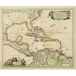
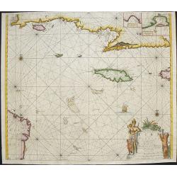
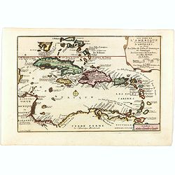
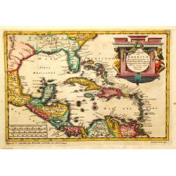
Insulae Americanae in Oceano Septentrionali. . .
A particularly handsome map portraying the south-eastern U.S., the Caribbean islands, part of Mexico, Central America, Florida (called tegesta Prov. ) and part of South A...
Date: Amsterdam, 1690
Selling price: ????
Please login to see price!
Sold in 2019
![Terre Artiche... [Arctic]](/uploads/cache/94033-250x250.jpg)
Terre Artiche... [Arctic]
Coronelli's map of the Arctic Circle, illustrating a speculative Northwest Passage and Northeast Passage around the North Pole. The American place names are given by Engl...
Date: Venice, c. 1690
Selling price: ????
Please login to see price!
Sold in 2014
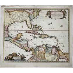
Insulae Americanae, in Oceano Septentrionali ac Regiones Adiacentes.
The full title and impressum in a cartouche held by putti top right: 'Insulae Americanae, in Oceano Septentrionali ac Regiones Adiacentes, a C. de May ad Lineam Aequinoct...
Date: Amsterdam, 1690
Selling price: ????
Please login to see price!
Sold in 2021
Isole Antilles, La Cuba, e la Spagnuola...
The West Indies from Cuba to Trinidad.
Date: Venice, c.1692
Selling price: ????
Please login to see price!
Sold
Nova et Accurata Poli Arctici et Terrarum Circum Iacentium Descriptio.
Map of the North Pole and surrounding countries. Title in a decorated cartouche at top; impresses in a cartouche with an ice bear and hunters at bottom right: 'Amstelodam...
Date: Amsterdam, 1694
Selling price: ????
Please login to see price!
Sold in 2020
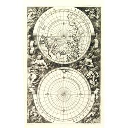
Polus Arcticus / Polus Antarcticus Tom II p.11.
A very interesting map with vertical orientation showing twin polar projections. The South Pole shows Tierra del Fuego as the only land, and the North Pole includes a por...
Date: Nuremberg, 1696
Selling price: ????
Please login to see price!
Sold in 2010
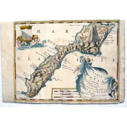
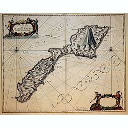
Isola Di Mayen Scoperta l'Anno 1614...
A fine,rare map of Jan Mayen Island, which was discovered in 1614 by a Dutch whaling captain, northeast of Iceland. With two large, very decorative cartouches. A large vo...
Date: Venice, 1696
Selling price: ????
Please login to see price!
Sold in 2017
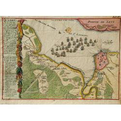
Quebec, Ville de l'Amerique Septentrionale dans la Nouvelle France.
A second state of the early map of Quebec by Nicolas de Fer. The maps illustrates Sir William Phips' attack on Quebec in 1690. Following his success at Port Royal, Phips ...
Date: Paris, 1696
Selling price: ????
Please login to see price!
Sold in 2019
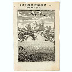
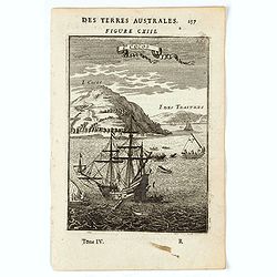
Terres ANTARCTIQUES.
Delightful map of the South Pole, including southern tips of Africa and America as well as drafts of Australia, New Zealand and some Islands of Polynesia.
Date: Amsterdam 1700
Selling price: ????
Please login to see price!
Sold
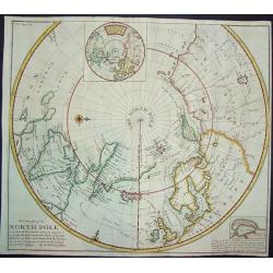
Terres ARCTIQUES.
Delightful map of the North Pole, including Greenland, Scandinavia, Canada and Russia.
Date: Amsterdam 1700
Selling price: ????
Please login to see price!
Sold
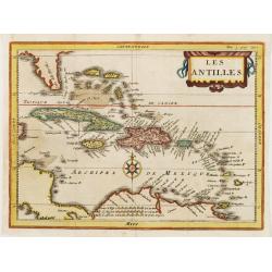
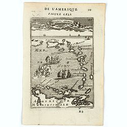
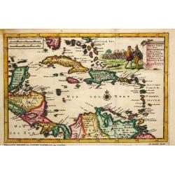
Les ANTILLES.
Attractive map of the Greater and Lesser Antilles.
Date: Amsterdam 1700
Selling price: ????
Please login to see price!
Sold
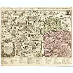
CARTE QUI REPRESENTE TOUTES LES PIECES QUI SONT COMPRISE DANS L'ARCHITECTURE MILITAIRE OU L'ART DES FORTIFICATIONS...
Attractive copper-engraved print of military objects, weapons, cannons, fortifications, buildings, ships, tools, etc. Includes an extensive key with more than 84 descript...
Date: Amsterdam, 1700
Selling price: ????
Please login to see price!
Sold in 2015
Hos Globos Terracqueum, ac Coelestem Dicat. . .
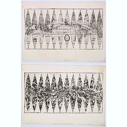
A very rare pair of 15 cm (6 inch) globe gores.Two sets of 12 gores on 2 sheets for a pair of terrestial and celestial globes. Terrestria: California as an island, Terra ...
Date: Venice, 1700
Selling price: ????
Please login to see price!
Sold in 2020
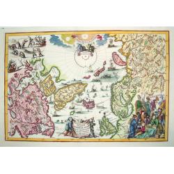
Regionum Circum Polarium Lapponiae Islandiae et Groenlandiae...
A highly decorative and sought after map of the North Pole filled with images of sailing ships, sea monsters, hunting, whaling and exploration. This work provides cartogr...
Date: Munich, 1701
Selling price: ????
Please login to see price!
Sold
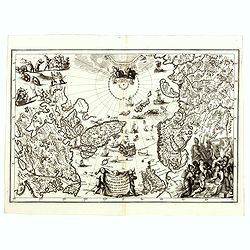
Regionum Circum Polarium Lapponiae Islandiae et Groenlandiae.
A highly decorative and scarce map of the Arctic regions on Canada, Scandinavia and Russia, along with the North Atlantic. Filled with images of sailing ships, sea monste...
Date: Munich, 1701
Selling price: ????
Please login to see price!
Sold in 2016
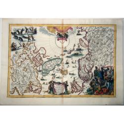
Regionum Circum Polarium Lapponiæ Islandiæ Et Groenlandiæ Novae Et Veteris Nova Descriptio Geographica.
This north polar projection map is a busy, decorative map, showing the North Pole, North America and the northwest of Europe and Asia, including Greenland, Lapland, the B...
Date: Munich, 1701
Selling price: ????
Please login to see price!
Sold in 2021
Iukatan en vaste kusten van Nieuw Spanje..
An attractive map showing the Caribbean.Although not renowned for the originality of his work, Pieter van der Aa is highly thought of for the design and quality of his ou...
Date: Leiden 1705
Selling price: ????
Please login to see price!
Sold
This Draught of the North Pole...to find out the N. East and N. West Passages
A boldly engraved chart of the polar region that shows the latest discoveries and routes of various explorers during their attempts to find a Northwest and Northeast pass...
Date: London, ca. 1705
Selling price: ????
Please login to see price!
Sold in 2008
Les Isles De L'Amerique Connues Sous le Nom D'Antilles, ou Sont les Isles de Cuba, St. Domingue et Jamaique les Lucayes, les Caribes . . .
Decorative and detailed map of the Florida Keys, Caribbean and coasts of Central and South America from an early edition of De Fer's "Atlas Curieux". De Fer's m...
Date: Paris, 1705
Selling price: ????
Please login to see price!
Sold in 2019
![Atlas. [Complete set of Terrestrial and Celestial Gores]](/uploads/cache/46535-250x250.jpg)
Atlas. [Complete set of Terrestrial and Celestial Gores]
A rare complete set of gores for a pair of 30cm (12-inch) diameter globes, on full uncut sheets with deckle edges. Eimmart is described in Tooley's Dictionary of Mapmaker...
Date: Nuremberg, 1705
Selling price: ????
Please login to see price!
Sold in 2020
Reys Togt Door Gil Gonzales Davila van 't Eyland St. Dominica Gedaan na de Honduras en Nicaragua.
Pieter van der Aa was a prolific publisher. He published a.o. ' Naauwkeurge versameling der gedenkwaardigste zee- en land-reysen', a series of accounts of voyages (1706-0...
Date: Leiden, 1707
Selling price: ????
Please login to see price!
Sold
De Voor Eylanden van America.
Pieter van der Aa was a prolific publisher. He published a.o. ' Naauwkeurge versameling der gedenkwaardigste zee- en land-reysen', a series of accounts of voyages (1706-0...
Date: Leiden, 1707
Selling price: ????
Please login to see price!
Sold
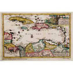
t Vaste Land van Darien ten Zuiden Cuba en Hispaniola Gelegen.
An attractive map showing Colombia, Venezuela and the Caribbean. Embellished with a large and decorative title-cartouche.Pieter van der Aa was a prolific publisher. He pu...
Date: Leiden, 1707
Selling price: ????
Please login to see price!
Sold in 2020
