Browse Listings in Australia & Oceania > Oceania
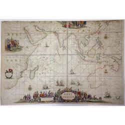
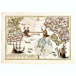
OOST INDIEN Wassende-Graade Paskaart, vertoonende nevens het Oosterlykste van Afrika, meede de Zeekusten van Asia, van C. de Bona Esperance tot Eso, boven Japan. . .
Sea chart of the East Indies on Mercator projection delineating not only the eastern coast of Africa, but also the coasts of Asia, from the C. of Good Hope till Eso, nort...
Place & Date: Amsterdam, ca. 1690
Selling price: $38000
Sold in 2015
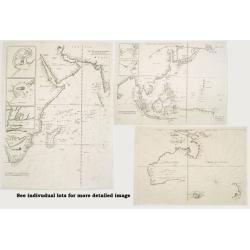
Group of three maps.
The bid amount for the 3 individual maps was higher than the bid for the set. Therefor the maps are sold at an individual base. A group of three important maps:1./ Theve...
Place & Date: Paris 1664-1696
Selling price: $14800
Sold
![Globe gore [ Het Niew Hollandt..] (New Holland)](/uploads/cache/31208-250x250.jpg)
Globe gore [ Het Niew Hollandt..] (New Holland)
A globe gore including the Spice Islands, Papua New Guinea and the North Coast of Australia and an explanatory of "Lochac". Italian text below the map which is ...
Place & Date: Venice, 1696
Selling price: $2300
Sold in 2011
![[Asia]](/uploads/cache/91287-250x250.jpg)
[Asia]
Important Asia map of V.M. Coronelli showing SE Asia with Japan and parts of Australia and New Zealand. Many discoveries around Australia are described with dates, place ...
Place & Date: Venice, 1697
Selling price: $1800
Sold in 2009
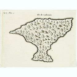
Isle de Ladrones.
Early map of the Mariana Islands (up to the early 20th century sometimes called Ladrones Islands, from Spanish Islas de los Ladrones meaning "Islands of Thieves"...
Place & Date: Amsterdam, E. Roger, 1702
Selling price: $80
Sold in 2013
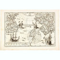
Tantum distamus ap invicem.
A map from the series of maps by the Jesuit mathematician. The map is centered on the Pacific Ocean between Asia and North America. It is an illustration of an uncommon p...
Place & Date: Munich, 1703
Selling price: $700
Sold in 2014
Tantum distamus ap invicem.
A map from the series of maps by the Jesuit mathematician. The map is centered on the Pacific Ocean between Asia and North America. It is an illustration of an uncommon p...
Place & Date: Munich, 1703
Selling price: $450
Sold in 2018
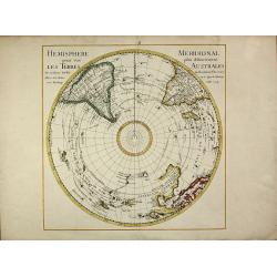
Hemisphere Meridional pour voir plus distinctement les Terres Australes
First edition of the important map of the southern hemisphere by de l'Isle in early strong colors, first published in 1714. This early map of the South Polar regions beca...
Place & Date: Paris, 1714
Selling price: $1000
Sold in 2013
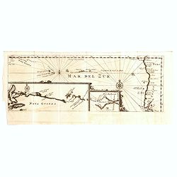
Mar del Zur / Nova Guinea / Terra del Fuogo.
Uncommon map depicting the west coast of South America (with inset map of Tierra del Fuogo) on the extreme right of the map, to Nova Guinea to the left. From the French r...
Place & Date: Amsterdam, F. Bernard, 1725
Selling price: $85
Sold in 2018
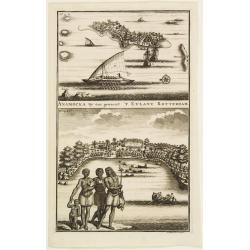
ANAMOCKA By ons genaent 'T EYLANT ROTTERDAM.
2 views on the Salomon Islands on one plate. The scenes illustrate indigenous people on the foreground while the European are represented on the background, discharging b...
Place & Date: Amsterdam 1726
Selling price: $55
Sold