Browse Listings in Australia & Oceania > Oceania
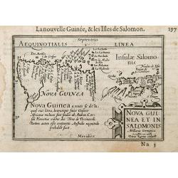
Nova Guinea et In. Salomonis.
Early nice map of New Guinea. The Solomon Islands appear on the right hand portion of the plate. Title cartouche on the lower right corner.First published in 1598 in his ...
Place & Date: Amsterdam / Frankfurt 1609
Selling price: $200
Sold
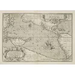
Maris Pacifici.
This was the first printed map to be devoted solely to the Pacific, and the first to name North and South America separately. It includes most of North and South America,...
Place & Date: Antwerp, 1590-1612
Selling price: $6000
Sold in 2010
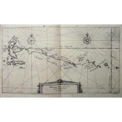
Beschreibung Novae Guineae, wie die von Wilhelm Schouten umbfahren.
Rare and very early map of New Guinea, published in Frankfurt in 1619, as part of Hulsius' Sechtzehende Schiffahrt, which retold the voyage of Willem Schouten. Schouten ...
Place & Date: Frankfurt, 1619
Selling price: $700
Sold in 2009
![[Cavendish meets the natives at Guam.]](/uploads/cache/40369-250x250.jpg)
[Cavendish meets the natives at Guam.]
During Thomas Cavendish’s voyage to the Spice Islands of the East, he dropped anchor in 1587 at Guam in the Ladrones, known as the Islands of Thieves. At least sixty ca...
Place & Date: Frankfurt, M.Merian, 1633
Selling price: $90
Sold in 2017
![[What the Dutch experienced at the Ladrones Islands.]](/uploads/cache/40370-250x250.jpg)
[What the Dutch experienced at the Ladrones Islands.]
At the Marianas Islands, the Dutch ship was visited by about 200 small boats, each containing 2 or 3 people. To do trade with them, the Dutch let down ironware by means o...
Place & Date: Frankfurt, M.Merian, 1633
Selling price: $105
Sold in 2017
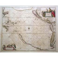
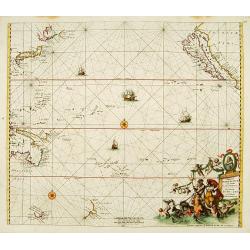
Mar Del Zur Hispanis Mare Pacificum.
Jansson's fine map of the Pacific including the west coast of America, Japan and a small Australian coastline. This is one of the earliest maps of the Pacific. The first ...
Place & Date: Amsterdam, c.1650
Selling price: $1800
Sold in 2015
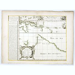
La Mer de Sud dite autrement Mer Pacific Par P. Du-val. . .
Lower left sheet of a 4 sheet map of the Pacific. This sheet showing part of the South Sea with Nova Guinea, Carpentaria, Van Diemen's Land, New Zealand and "Terres ...
Place & Date: Paris, 1679
Selling price: $3850
Sold in 2016
Magnum Mare del Zur.
Based on Goos' 1666 map, California depicted with an indented northern coastline following the second Sanson model. Tasmania, NW Australia and Carpentaria appear, as does...
Place & Date: Amsterdam 1680
Selling price: $2875
Sold
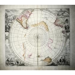
Polus Antarcticus (rare IV State).
A nice example of the rare De Wit edition of the famous, large hemispherical map of the Antarctic region, originally published by Hondius. In this edition the discoveries...
Place & Date: Amsterdam, 1680
Selling price: $1040
Sold in 2020
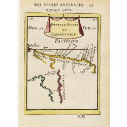
Nouvelle Guinée et Carpentarie.
A charming late 17th century French map of the coast of Australia round Carpentaria Bay and New Guinea. Title displayed on a draped cloth above.
Place & Date: Paris 1683
Selling price: $95
Sold