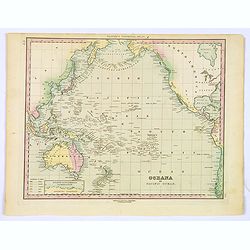
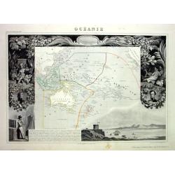
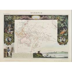
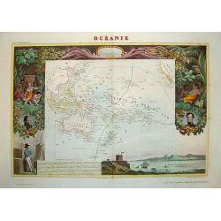
Browse Listings in Australia & Oceania > Oceania
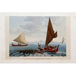
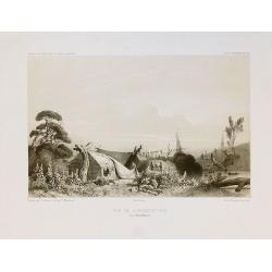
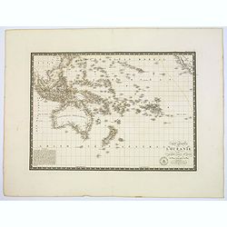
Vue De L'Île Tinian: Pirogues des ÎLes Carolines.
Superb stipple engraving with fantastic color showing two boats and several native sailors. In the background two more boats and an island are visible. By Taunay for Frey...
Date: Paris, 1825
Selling price: ????
Please login to see price!
Sold in 2016
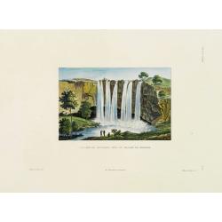
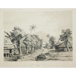
Cascade de Fanafaoua près du village de Kidikidi.
Original hand colored engraving by Ambroise Tardieu taken from the rare and important book " Voyage autour du Monde, exécuté par ordre du Roi, sur la corvette de s...
Date: Paris, Arthus Bertrand, 1826
Selling price: ????
Please login to see price!
Sold in 2011
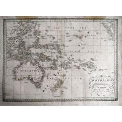
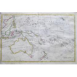
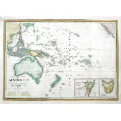
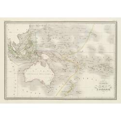
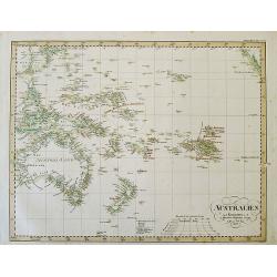
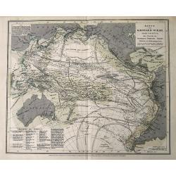
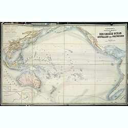
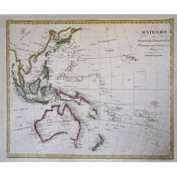
AUSTRALIEN entworfen und gezeichnet 1823...
Scarce and very detailed German map of Australia and Oceania. Dated 1823 but updated until 1826 with superb geography and many details. The map shows the entire Pacific...
Date: Weimar, 1826
Selling price: ????
Please login to see price!
Sold in 2013
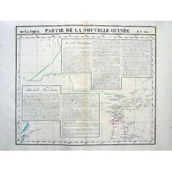
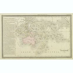
Partie de la Nouvelle Guinée. No30
Highly detailed and important map showing the Torres Strait between New Guinea and Australia. With extensive descriptive text in French. Lithograph with original hand-col...
Date: Brussels, 1827
Selling price: ????
Please login to see price!
Sold in 2008
![[ Pacific Palau Islands Inhabitants ].](/uploads/cache/26363-250x250.jpg)
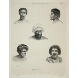
[ Pacific Palau Islands Inhabitants ].
Aquatint depicting Pacific Palau Islands inhabitants engraved by Carlo Bottigella Plate N° 76. English Captain Henry Wilson also shipwrecked off the island of Ulong in 1...
Date: Milan, 1827
Selling price: ????
Please login to see price!
Sold in 2014
![[Easter Island ].](/uploads/cache/26372-250x250.jpg)
[Easter Island ].
Aquatint depicting men discovering the Easter Island Statues engraved by Carlo Bottigella. Plate N° 89. From Giulio Ferrario's work Le Costume Ancien et Moderne ou Histo...
Date: Milan, 1827
Selling price: ????
Please login to see price!
Sold in 2017
![[ Pacific Palau Island Bay ].](/uploads/cache/26383-250x250.jpg)
[ Pacific Palau Island Bay ].
Aquatint depicting Palau Island Bay engraved by Fumagalli. Plate N° 76. The English Captain Henry Wilson shipwrecked off the island of Ulong in 1783. Wilson dubbed Palau...
Date: Milan, 1827
Selling price: ????
Please login to see price!
Sold in 2014
![[ Pacific Palau Islands tools ].](/uploads/cache/26382-250x250.jpg)
[ Pacific Palau Islands tools ].
Aquatint depicting a variety of Pacific Palau Islands tools engraved by Carlo Bottigella Plate N° 76. English Captain Henry Wilson shipwrecked off the island of Ulong in...
Date: Milan, 1827
Selling price: ????
Please login to see price!
Sold in 2013
![[Volume 6 ]Oceania. (Atlas universel de geographie, physique, politique, statistique et mineralogique.)](/uploads/cache/32433-250x250.jpg)
[Volume 6 ]Oceania. (Atlas universel de geographie, physique, politique, statistique et mineralogique.)
The volume of Oceania covering Australia, New Zealand, Hawaii, Indonesia with Java, Philippines, Singapore. This monumental work was the first atlas of the world with all...
Date: Brussels, Ph. Vandermaelen, 1827
Selling price: ????
Please login to see price!
Sold in 2012
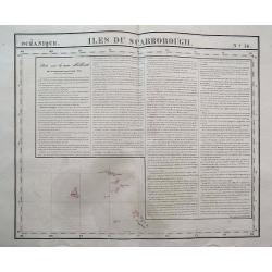
Iles Du Scarborough.
Interesting map showing Cook Island, Iles Simpson, and several others. With lengthy text about New Holland! Scarce and sought-after map from the first lithographic atlas...
Date: Brussels, 1827
Selling price: ????
Please login to see price!
Sold in 2016
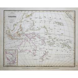
Oceanica 1828.
An uncommon Italian map of South-East Asia, Australia, New Zealand, Hawaii, and the southern Pacific. It shows and names many islands and places along the coasts. Also sh...
Date: ca. 1828
Selling price: ????
Please login to see price!
Sold in 2017
Oceanica.
This attractive map of the region covering Japan to North America, Australia and New Zealand from the Comprehensive Atlas of Modern Geography, an extraordinarily well exe...
Date: Edinburgh, 1829
Selling price: ????
Please login to see price!
Sold in 2015
Iles Viti et Nlle Irlande.
From "Voyage de la corvette l'Astrolabe exécuté par Ordre du Roi pendant les années 1826 - 1827 - 1828 - 1829 sous le commandement de M. Jules Dumont d'Urville, C...
Date: Paris, 1830
Selling price: ????
Please login to see price!
Sold in 2011
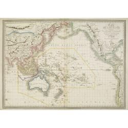
Australien nach Krusenstern, Flinders, Freycinet, Oxley. . .
A scarce early edition of this detailed German map of Australia and Oceania. It extends to show the entire southern Pacific Ocean, from China to California, including Jap...
Date: Weimar, 1830
Selling price: ????
Please login to see price!
Sold in 2018
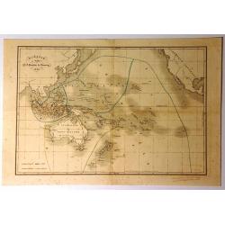
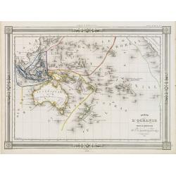
Carte de l\'Océanie comprenam l\'Australie, la Polynésie et du grand archipel d\'Asie.
Map of Oceania showing the tracks of Cook and La Perouse and those of the voyage in search of La Perouse. Relief shown by hachures. There is also a frame on the top left ...
Date: Paris, 1833
Selling price: ????
Please login to see price!
Sold in 2010
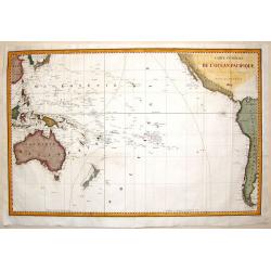
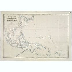
Carte Generale de L'Ocean Pacifique.
Sea chart depicting the Pacific Ocean. Shows the South East Asian area including Australia and New Zealand. Jules Sébastien César Dumont d'Urville (1790 – 1842)was ...
Date: Paris, 1834
Selling price: ????
Please login to see price!
Sold in 2016
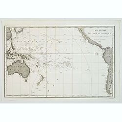
Carte générale de l'océan pacifique. . .
depicting the Pacific Ocean, with nice detail of Hawaii. With a complete outline for Australia and Tasmania. Shows the south east Asian region and South America. Jules S...
Date: Paris, 1834
Selling price: ????
Please login to see price!
Sold in 2021
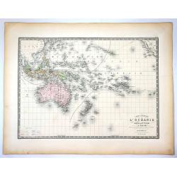
Carte de l'Océanie.
Steel engraving of Australia, New Zealand and Indonesia. Engraved by Thierry.Published by Conrad Malte-Brun (1775-1826). Mapping of Australia [+]
Date: Paris, c.1835
Selling price: ????
Please login to see price!
Sold in 2023
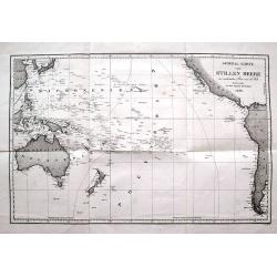
General-Karte vom Stillen Meere...
Large and very interesting map of the Pacific Ocean. Shows the area from South Korea and Japan, the Philippines, Taiwan, Australia and New Zealand, to California, Panama,...
Date: Paris, 1836
Selling price: ????
Please login to see price!
Sold in 2016
Oceanie.
Finely engraved map of the Pacific Ocean with Australia and New Zealand, prepared by A.H.Dufour and engraved by Giraldon-Bovinet. Published by Jules Renouard in his uncom...
Date: Paris, Jules Renouard, ca.1840
Selling price: ????
Please login to see price!
Sold in 2012
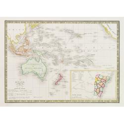
Oceanie
Interesting map of Oceania featuring Australia, Micronesia, Malaysia and Polynesia. It also has the south-west coast of America with a strange looking California. There i...
Date: Paris, 1840
Selling price: ????
Please login to see price!
Sold in 2015
Oceana or Pacific Ocean.
A lovely detailed map of the Pacific, centered on Hawaii, from an early edition of Tanner's New Universal Atlas.
Date: Philadelphia, ca 1840
Selling price: ????
Please login to see price!
Sold in 2019
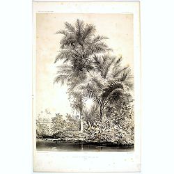
Bouquet de Palmiers dans L'Ile Tsis.
A desirable lithograph of beautiful tall Palm trees growing on the L'Ile Tsis, a part of the Cook Islands in the Pacific. Plate 100 taken from the 'Voyage au Pole et dans...
Date: Paris, 1842
Selling price: ????
Please login to see price!
Sold in 2017
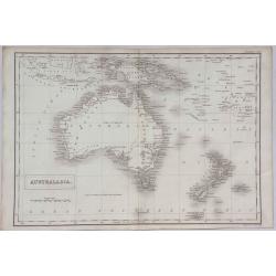
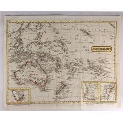
Australasia.
A detailed map of Australasia from Sidney Hall's scarce 1843 "New General Atlas”. Adam & Charles Black were among the leading publishers of atlases and travel ...
Date: London, 1843
Selling price: ????
Please login to see price!
Sold in 2021
Océanie.
Detailed map of the Pacific with Australia, New Zealand, Indonesia and California. Lower right inset map of the south east coast of Australia Colonie Anglaise de la Nouve...
Date: Paris 1845
Selling price: ????
Please login to see price!
Sold
Carte de L'Océanie..
Decorative map of the Pacific with Australia, New Zealand, Indonesia and California, prepared by J.G.Barbié du Bocage.Engraved by Ch.Smith, published by Basset who was e...
Date: Paris 1846
Selling price: ????
Please login to see price!
Sold
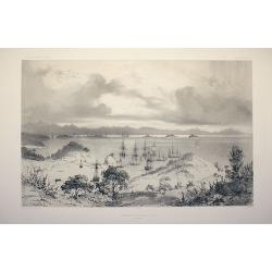
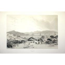
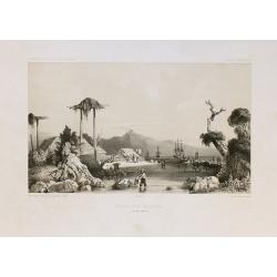
Mouillage de Korora-Reka (Baie des Isles)
Drawn by L. Le Breton and engraved by Sabatier.
Date: Paris, Gide, 1846
Selling price: ????
Please login to see price!
Sold in 2008
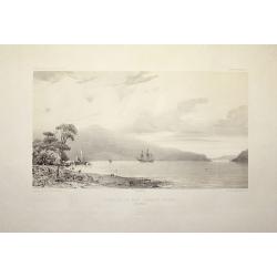
Fond de la baie Sarah's Bossom (Iles Aukland)
Drawn by L. Le Breton and engraved by Guiaud.
Date: Paris, Gide, 1846
Selling price: ????
Please login to see price!
Sold in 2008
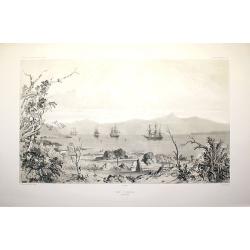
Baie d'Akaroa (Nouvelle Zélande)
Drawn by L. Le Breton and engraved by Sabatier.
Date: Paris, Gide, 1846
Selling price: ????
Please login to see price!
Sold in 2008
Port d'Otago (Nouvelle Zélande)
Drawn by L. Le Breton and engraved by Sabatier.
Date: Paris, Gide, 1846
Selling price: ????
Please login to see price!
Sold in 2008
AUSTRALIEN nach Krusenstern u. A. in Meractors Projection...
A fantastic steel engraved map of Australia and the Pacific. Published in Stieler's Hand-Atlas.Dated 1826 but updated until around 1845 with superb geography and exact de...
Date: Gotha, c1846
Selling price: ????
Please login to see price!
Sold in 2012
Carte générale de l'Océan Pacifique dressée Par Mr. C,A, Vincendon-Dumoulin 1845 Expédition au Pole Austral et dand l'Oéanie, commondée par M.Durmont d'Urville . . .
Four-sheet map of the Pacific Ocean showing good detail on Australia, New Zealand and the west coast of North and South America. In lower margin: Le plan grave´ par Jaco...
Date: Paris, 1847
Selling price: ????
Please login to see price!
Sold in 2013
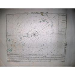
Carta Generale dell'Antartica.
Benedetto Marzolla, was among the most relevant of the Italian cartographers of the XIX century, he used very high quality lithographies for his maps. His 'Atlante Geogra...
Date: Naples, 1848
Selling price: ????
Please login to see price!
Sold in 2017
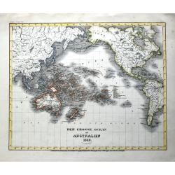
Asiatischer Archipel und Neu Holland 1847 / Der Grosse Ocean und Australien 1849.
Two interesting steel engraved maps of Southeast Asia and the Pacific.(1) Asian Archipelago and New Holland 1847: The map shows Australia as well as Indonesia, Malacca (M...
Date: Hildburghausen, 1849
Selling price: ????
Please login to see price!
Sold in 2021
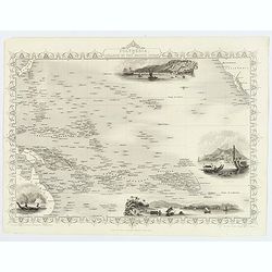
Océanie
Very decorative steel-engraved map of Australia and the Pacific. Ornately decorated with Indians, plants, portraits, harbor view and descriptive text.
Date: Paris, 1850
Selling price: ????
Please login to see price!
Sold
Océanie.
An attractive map from one of the last decorative atlases of the nineteenth century. The map covers the entire South Pacific including Australia and New Zealand and South...
Date: Paris 1850
Selling price: ????
Please login to see price!
Sold
ASIATISCHER ARCHIPEL UND NEU HOLLAND 1849
Steel engraved map from "Meyers Zeitungs und Groschen-Atlas" by J. Meyer, considered on of the best German atlases in the 19th century.Very detailed representat...
Date: Hildburghausen, c1850
Selling price: ????
Please login to see price!
Sold in 2008
Karte vom Grossen Ocean...
Interesting map of the Pacific Ocean, showing a wealth of currents, routes and dates of explorations , temperatures, etc.
Date: Hildburghausen, ca. 1850
Selling price: ????
Please login to see price!
Sold in 2016
Australien (Oceanien)
Striking German map of Australia and Polynesia with three inserts including Van Diemens Land, West Australia and New South Wales. The map maker is unknown and the map is...
Date: Germany, c. 1850
Selling price: ????
Please login to see price!
Sold in 2017
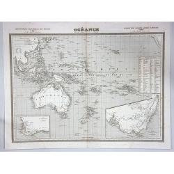
Océanie.
A large and detailed map of Australasia, with insets of New South Wales and the south west corner of Australia. An uncommon map including Australia, New Zealand and Indon...
Date: Paris, ca 1850
Selling price: ????
Please login to see price!
Sold in 2017
Polynesia or Islands in the Pacific Ocean.
Decorative and attractive map of the Islands in the Pacific Ocean.
Date: London ,1851
Selling price: ????
Please login to see price!
Sold in 2016
Polynesia or Islands in the Pacific Ocean.
A decorative and attractive map of the Islands in the Pacific Ocean. The map extent shows parts of California, Papua New Guinea, eastern Australia, and southern Japan.The...
Date: London ,1851
Selling price: ????
Please login to see price!
Sold in 2017
Polynesia or Islands in the Pacific Ocean.
A decorative and attractive map of the Islands in the Pacific Ocean. The map extent shows parts of California, Papua New Guinea, eastern Australia, and southern Japan.The...
Date: London ,1851
Selling price: ????
Please login to see price!
Sold in 2019
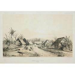
Village d\'Umata (Ile Gouaham).
Two-shades plate engraved for the "Atlas Pittoresque - Voyage au Pôle Sud et dans l'Océanie, sur les corvettes l'Astrolabe et la Zélée, exécuté par ordre du Ro...
Date: Paris, 1841-1854
Selling price: ????
Please login to see price!
Sold in 2011
Baie de Sarah's Bosom (Iles Auckland)
Plate engraved for the "Atlas Pittoresque - Voyage au Pôle Sud et dans l'Océanie, sur les corvettes l'Astrolabe et la Zélée, exécuté par ordre du Roi pendant l...
Date: Paris, 1841-1854
Selling price: ????
Please login to see price!
Sold in 2008
Vue de l'Observatoire.
Two-shades plate engraved for the "Atlas Pittoresque - Voyage au Pôle Sud et dans l'Océanie, sur les corvettes l'Astrolabe et la Zélée, exécuté par ordre du Ro...
Date: Paris, 1841-1854
Selling price: ????
Please login to see price!
Sold in 2010
Grande rue d\'Umata.
Two-shades plate engraved for the "Atlas Pittoresque - Voyage au Pôle Sud et dans l'Océanie, sur les corvettes l'Astrolabe et la Zélée, exécuté par ordre du Ro...
Date: Paris, 1841-1854
Selling price: ????
Please login to see price!
Sold in 2011
Mouillage d'Otago.
Two-shades plate engraved for the "Atlas Pittoresque - Voyage au Pôle Sud et dans l'Océanie, sur les corvettes l'Astrolabe et la Zélée, exécuté par ordre du Ro...
Date: Paris, 1841-1854
Selling price: ????
Please login to see price!
Sold in 2010
Grande rue de Merizo.
Two-shades plate engraved for the "Atlas Pittoresque - Voyage au Pôle Sud et dans l'Océanie, sur les corvettes l'Astrolabe et la Zélée, exécuté par ordre du Ro...
Date: Paris, 1841-1854
Selling price: ????
Please login to see price!
Sold in 2011
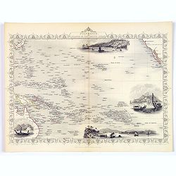
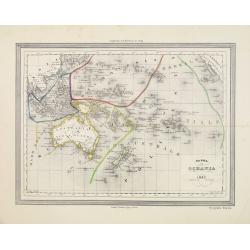
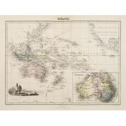
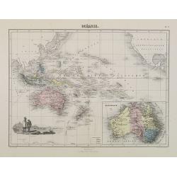
Oceania.
Beautiful steel plate map of the Oceania region. A very decorative work featuring depictions of indigenous peoples pursuing various activities, foliage and geographic sce...
Date: Paris, ca. 1855
Selling price: ????
Please login to see price!
Sold in 2010
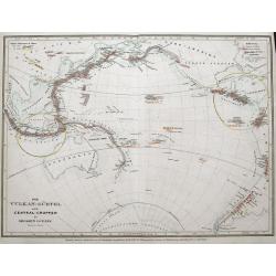
Der Vulkan-Gürtel und die Central-Gruppen des grossen Oceans.
Map shows the volcano's around the Pacific Ocean, China, Indonesia, Hawaii, and the Americas. Active volcano's are underlined in orange. Two circled areas show the main g...
Date: Hildburghausen, ca. 1855
Selling price: ????
Please login to see price!
Sold in 2015
Carta dell' Oceania 1857
Uncommon Italian map of Australia, New Zealand, Indonesia and the Pacific till Mexico. Map is in outlined color.Many Indian names and settlements.From Geografia Storica a...
Date: Turin, 1857
Selling price: ????
Please login to see price!
Sold in 2012
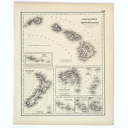
Hawaiian Group or Sandwich Islands.
This is Colton's map of Hawaii, New Zealand, and several Polynesian island groups. The sheet has seven separate maps. The top map,which occupies the top half of the sheet...
Date: New York, ca. 1857
Selling price: ????
Please login to see price!
Sold in 2017
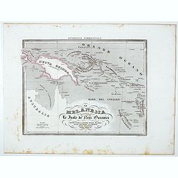
La Melanesia ossla Le Isole de Meri Oceanici . . .
Uncommon map of New Guinea, Solomon Islands prepared by Francesco Costantino Marmocchi. Above the map "Geografia Commerciale". From "Il Globo Atlante di ca...
Date: Genova, Paolo Rivara fu Giacomo, 1858
Selling price: ????
Please login to see price!
Sold in 2021
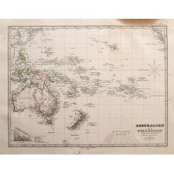
Australien und Polynesien in Mercators Projection.
Interesting and very detailed map of Australia and the Pacific Ocean, including a part of China, Japan, New Zealand, Hawaii, and a small part of California. With many sma...
Date: Gotha, 1863
Selling price: ????
Please login to see price!
Sold in 2014
Océanie.
An uncommon map of Australia, New Zealand, and the South Pacific, it extends from Indo-China until California including Hawaii.Names hundreds of small islands and places ...
Date: Paris, 1864
Selling price: ????
Please login to see price!
Sold in 2017
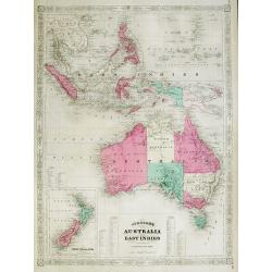
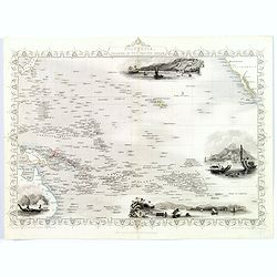
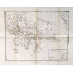
Johnson's Australia and East Indies
Very attractive and large map of Australia, the East Indies and Southeast Asia. Extends from Thailand and Vietnam, south to include all of the East Indies, the Philippine...
Date: New York, 1867
Selling price: ????
Please login to see price!
Sold in 2012
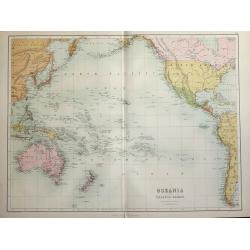
Oceania and Pacific Ocean.
A highly detailed map of the Pacific rim counties from Russia - China to Australia & New Zealand to North & South America's western coasts. Original coloring sepa...
Date: Edinburgh, 1870
Selling price: ????
Please login to see price!
Sold in 2014
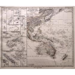
Polynesien und der grosse Ocean. . .
Highly detailed map of Southeast Asia, Australia and New Zealand. With numerous inset maps of islands: Carolinas, Marianas, Samoa, Fidji, New Caledonia, Tonga,... Early...
Date: Gotha, 1873
Selling price: ????
Please login to see price!
Sold in 2014
Océanie.
Decorative map of Australia, New Zealand and other islands of the Pacific from Géographie Universelle, Atlas Migeon. published by J. Migeon. In lower left an engraving o...
Date: Paris, 1874
Selling price: ????
Please login to see price!
Sold in 2009
Océanie.
Decorative map of the Pacific and its vicinities from Géographie Universelle, Atlas Migeon, published by J. Migeon. In lower right hand corner a map of Australia.From on...
Date: Paris, 1874
Selling price: ????
Please login to see price!
Sold in 2015
Physikalische Wandkarten. VIII. Der Grosse Ocean (Australien und Polynesien).
Giantic School wall map of Australia and the Pacific printed in chromo-lithography, in very good to mint condition and with its original card board cover. Published by &q...
Date: Berlin, D. Reimer, 1875
Selling price: ????
Please login to see price!
Sold in 2013
Carte Generale de L'Oceanie Cinquieme Partie du Monde ...
Pleasant engraved map that shows the entire South Pacific Ocean. It extends to include the entire East Indies, southern China, part of Japan, and across the Pacific to sh...
Date: Paris , 1875
Selling price: ????
Please login to see price!
Sold in 2020
Carte Generale de l'Oceanie ou cinquieme partie du monde.
Pleasant engraved map that shows the entire South Pacific Ocean. It extends to include the entire East Indies, southern China, part of Japan, and across the Pacific to sh...
Date: Paris, 1875
Selling price: ????
Please login to see price!
Sold in 2017
![[no title] Australia, New Zealand, Indonesia, Africa, etc.](/uploads/cache/15711-250x250.jpg)
[no title] Australia, New Zealand, Indonesia, Africa, etc.
Detailed chart of south Africa and Australia, new Zealand and a tip of Antarctica. Updated till 1880.
Date: Paris 1874/1880
Selling price: ????
Please login to see price!
Sold in 2010
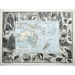
Australien.
An unusual German map of Australia surrounded by numerous images of birds, animals, and trees. Also shows aborigines and inhabitants of New Guinea, New Zealand, Samoa, Ne...
Date: Leipzig, ca 1880
Selling price: ????
Please login to see price!
Sold in 2021
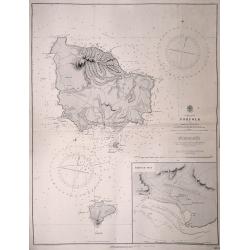
Norfolk and Philip Islands surveyed by Capt.n H.M. Denham R.N.
An original sea chart published at the Hydrographic Office of the Admiralty, April 4th, 1856. Admiralty chart no 1110 engraved by J. & C. Walker Includes inset of Syd...
Date: London, 1856-1911
Selling price: ????
Please login to see price!
Sold in 2014
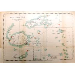
Fiji Islands
An interesting and scarce map of the Republic of Fiji, dated 1914, by the Lands Department. The map shows numerous islands, including Viti Levu, Vanua Levu, Taveuni, Lau ...
Date: London, 1914
Selling price: ????
Please login to see price!
Sold in 2016
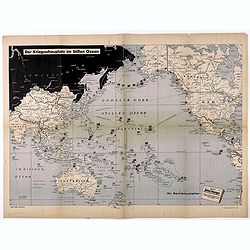
Der Kriegsschauplatz im Stillen Ozean.
Fascinating map of the Theater of War in the Pacific, published in Berlin.The map outlines the various regions of the Pacific controlled by the British, USA and Japan, wi...
Date: Berlin, ca. 1942
Selling price: ????
Please login to see price!
Sold in 2021
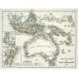
Australien nach den neuesten astronomischen Bestimungen und Entdeckungs-Reisen. in Wienn bey Tranquillo Mollo.
Rare, early Map of Oceana and South East Asia. It is a great (early) depiction of an unfinished Australia with unfinished southern coast of the continent, also new Guinea...
Date: Vienna, 1817-23
Selling price: ????
Please login to see price!
Sold in 2015
