Browse Listings in Australia & Oceania > New Zealand
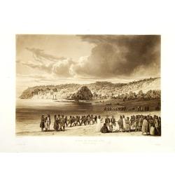
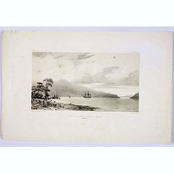
Plage de Kokora - Rêka (Nouvelle Zélande).
This plate comes from "Voyage autour du monde par les mers de l'Inde et de la Chine de la corvette de sa Majeste La Favorite execute pendant les annees 1830, 1831, 1...
Place & Date: Paris, no date 1835
Selling price: $375
Sold in 2010
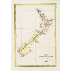
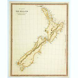
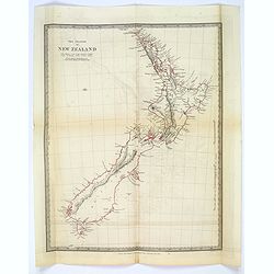
Carte de la Nouvelle-Zélande pour servir au Voyage pittoresque autor du Monde par M.D'Urville 1835
Map of New Zealand. Engraved by Ambroise Tardieu. Errors by Cook now updated.Dumont d'Urville was second in command on Duperrey's expedition of 1824 and later led his own...
Place & Date: Paris, L.Tenré, 1835
Selling price: $450
Sold in 2016
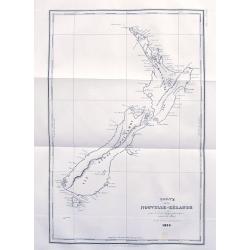
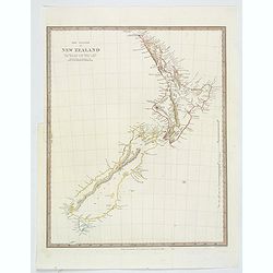
Carte de la Nouvelle-Zélande...
An early map of New Zealand after Dumont d'Urville's voyage on the Astrolabe. The larger French edition. Engraved by Tardieu.With numerous place names of bays, islands, e...
Place & Date: Paris, 1835
Selling price: $161
Sold in 2017
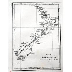
Karte von Neuseeland...
Early map of New Zealand after Dumont d'Urville's voyage on the Astrolabe. With numerous place names of bays, islands, ports, etc.
Place & Date: Paris, 1836
Selling price: $130
Sold in 2016

Karte von Neuseeland zur malerischen Reise um die Welt, 1836.
An early map of New Zealand after Dumont d'Urville's voyage on the Astrolabe. A German edition.With numerous place names of bays, islands, etc. With the Maori names of th...
Place & Date: Paris, 1836
Selling price: $160
Sold in 2017
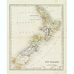
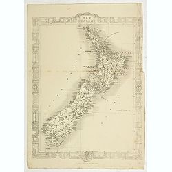
New Zealand.
Map of new Zealand engraved by John Dower who engraved maps for Orr's 1837 Atlas, "The British Cyclopaedia".
Place & Date: London, ca. 1837
Selling price: $150
Sold in 2020
The Islands of New Zealand.
This is a map of New Zealand produced by the Society for the Diffusion of Useful Knowledge (S.D.U.K.). It covers the entire island country from Cape Reinga (C. Maria Van ...
Place & Date: London, 1838
Selling price: $120
Sold in 2021
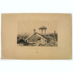
Cases de Naturels.
A lithograph of some classical Maori dwellings, the Bay of Islands in the North island of New Zealand. Plate 184 taken from the 'Voyage au Pole et dans L'Oceanie…' Depa...
Place & Date: Paris, 1842
Selling price: $20
Sold in 2019
The Islands of New Zealand.
This is a map of New Zealand produced by the Society for the Diffusion of Useful Knowledge (S.D.U.K.). It covers the entire island country from Cape Reinga (C. Maria Van ...
Place & Date: London, ca. 1844
Selling price: $165
Sold in 2019
Fond de la Baie Sarah's Bosom (Iles Aukland)
On 11 March 1840 Jules Dumont d’Urville, commanding the French ship Astrolabe, sailed from Hobart to the sub Antarctic Auckland Islands. This sweeping view is of the ba...
Place & Date: Paris, ca 1845
Selling price: $75
Sold in 2019
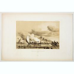
Agression des Naturels des Iles Opoulou.
A lithograph print of a confrontation between French sailors from the ships 'Astrolabe' & 'Zelle'' , under the command of Durmont D'Urville, in New Zealand waters, wi...
Place & Date: Paris, 1846
The Islands of New Zealand.
This is a map of New Zealand produced by the Society for the Diffusion of Useful Knowledge (S.D.U.K.). It covers the entire island country from Cape Reinga (C. Maria Van ...
Place & Date: London, ca. 1846
Selling price: $110
Sold in 2017
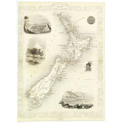
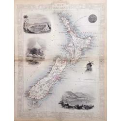
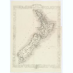
New Zealand.
Decorative steel engraved map of New Zealand, surrounded by illustrations of Auckland, Mount Egmont, a New Zealander, and the port of Wellington. Border in a New Zealand ...
Place & Date: London, 1851
Selling price: $500
Sold in 2010
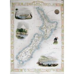
New Zealand.
An interesting and detailed map of the islands, with vignettes of Auckland, Mount Egmont from New Plymouth, Wellington and others.John Tallis was one of the last great de...
Place & Date: London, 1851
Selling price: $250
Sold in 2017
New Zealand.
Nice hand-colored lithograph map of New Zealand engraved by W. Hughes and published in Edinburgh by A. & C. Black in 1853. The map features insets of Tasmania and Wes...
Place & Date: Edinburgh, 1853
Selling price: $24
Sold in 2016
New Zealand.
Map of New Zealand, published by "The London Printing and Publishing Company". Drawn and engraved by John Rapkin.
Place & Date: London, 1854
Selling price: $100
Sold in 2022
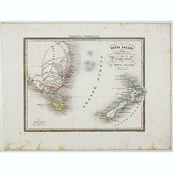
La Nuova Galles del Sud (Australia sud-est) La Diemenia e La Nuova Zelanda (Polinesia).
Uncommon map of East Coast of Australia and New Zealand prepared by Francesco Costantino Marmocchi. Above the map "Geografia Commerciale". From "Il Globo ...
Place & Date: Genova, Paolo Rivara fu Giacomo, 1858
New Zealand.
An attractive map of New Zealand, with plenty of map detail, and a decorative Maori style border, by J.Rapin, closely based on those map published by his contemporary, Jo...
Place & Date: London, ca 1860
Selling price: $35
Sold in 2020
New Zealand.
An unusual folding map of New Zealand. With several insets of other islands including Hawaii, Society Islands, Galapagos, Fiji,... Also with a detailed map of Dunedin and...
Place & Date: London & Liverpool, ca. 1860
Selling price: $20
Sold in 2019
NEW ZEALAND
Very attractive steel engraved map of New Zealand. A later edition after Tallis. Surrounded by illustrations of Auckland, Mount Egmont from New Plymouth, a Maori's tatto...
Place & Date: London, London Printing and Publishing Company, c.1860
Selling price: $448
Sold in 2011
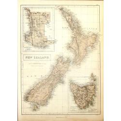
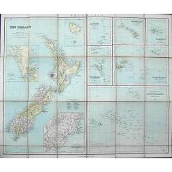
Pacific Ocean New Zealand
Large scale map of New Zealand from surveys by Captain J.L.Stokes, Commander B.Drury and G.H.Richards 1848-55. The chard was prepared in 1856 and corrected in 1858 and 18...
Place & Date: London, 1861
Selling price: $800
Sold
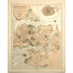
Der Isthmus von Auckland Mit Seinen Erloschenen Vulkanegein.
Interesting map of Auckland isthmus with its extinct volcanoes. Published by Gotha Justus Perthes and printed in the Novara Expedition in 1859. THE HARBOURS AND BAYS OF ...
Place & Date: Gotha, 1862
Selling price: $45
Sold in 2019
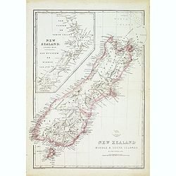
New zealand middle & south islands. . .
Detailed map of New Zealand engraved by John Dower for "The Weekly Dispatch Atlas".
Place & Date: London, 1863
Selling price: $150
Sold in 2014
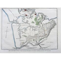
Map of the country between Auckland and the River Waikato, New Zealand, illustrating the war with the natives.
A scarce map illustrating the Land Wars between settlers in New Zealand and Maori people. It shows the area from Auckland until the Waikato River with interesting detail...
Place & Date: London, 1863
Selling price: $15
Sold in 2021
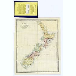
The Islands of New Zealand.
A lovely folding map of New Zealand, complete within its original blue boards, with original affixed yellow and black printed label. Inside cover has general information ...
Place & Date: London, ca 1863
Selling price: $250
Sold in 2018
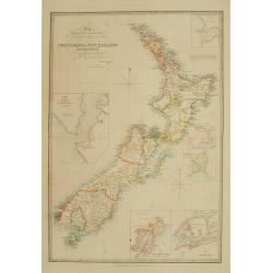
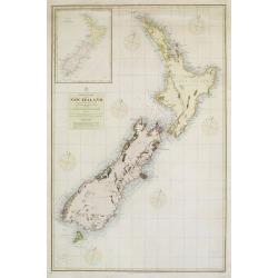
To the right.. this chart of New Zealand..
Very detailed map of New Zealand, with inset maps of entrance of the Hokianga River, Southern Port of Stewart's Island, plan of Dusky Bay, Port Nicocholson and a plan of ...
Place & Date: London 1864
Selling price: $1450
Sold
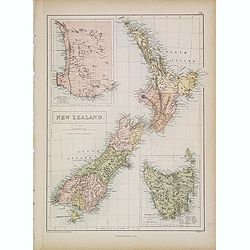
New Zealand.
A detailed lithographed map of New Zealand. With in upper left corner inset-map of Western Australia and in lower right hand corner a map of Van Diemens Land. Published b...
Place & Date: Edinburg, 1874
Selling price: $85
Sold in 2021
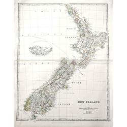
New Zealand.
The very detailed map of New Zealand includes a vignette view of the Southern Alps with mountains and the glacier named. The brothers William and Alexander Keith, were to...
Place & Date: Edinburgh, 1877
Selling price: $45
Sold in 2019
![[LOT OF 3 MAPS] New Zealand](/uploads/cache/97311-250x250.jpg)
[LOT OF 3 MAPS] New Zealand
A set of three 19th century maps:1) New Zealand. J. Bartholomew ca. 1880.2) New Zealand. unknown ca. 1870?3) New Zealand and the Australian colonies of Great Britain by V...
Place & Date: 1840-1880
Selling price: $2
Sold in 2016
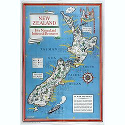
New Zealand. Her Natural and Industrial Recources.
Decorative Pictorial Map of New Zealand, by the celebrated illustrator Gill (Leslie) MacDonald Gill (1884 - died 1947) who produced for the British Ministry of Informatio...
Place & Date: London, Alf Cooke Ltd, 1943
Selling price: $1200
Sold
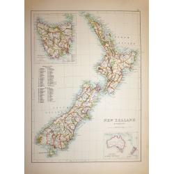
New Zealand & Tasmania
A superb map of New Zealand drawn and engraved by William Hughes – Sidney Hall steel engraved. Published by Adam & Charles Black in ‘General Atlas of the World’...
Place & Date: Edinburgh, 1854
Selling price: $60
Sold in 2019
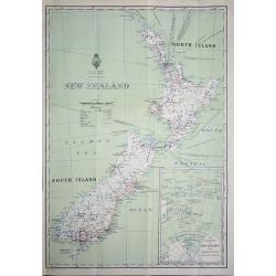
New Zealand
An interesting map of New Zealand’s North and South Islands, complete with an inset map of New Zealand’s position in the South Pacific Ocean. Printed by W. A. G. Skin...
Place & Date: Wellington, 1932
Selling price: $65
Sold in 2018