Browse Listings in Australia & Oceania > New Zealand
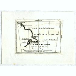
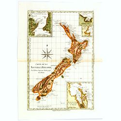
Nouva Zelanda, ò Terra Degli Stati, detta dagl'Hollandesi Het Niew Zelandt. scoperta dagli medemi l'anno 1654 . . .
RARE. This is the first printed map to dedicate to New Zealand, although the information dates back to Tasman in 1642. Showing from the Island of Three Kings to Cape Clip...
Place & Date: Naples, 1706
Selling price: $1150
Sold in 2016
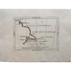
Nuova Zelandia, ò Terra Degli Stati, detta dagl'Hollandesi Het Niew Zelandt. scoperta dagli medemi l'anno 1654 . . .
Rare small map titled 'Nouva Zelanda, ò Terra Degli Stati, detta dagl'Hollandesi Het Niew Zelandt. scoperta dagli medemi l'anno 1654'. Earliest printed copper engraving ...
Place & Date: Venice, 1706
Selling price: $870
Sold in 2019
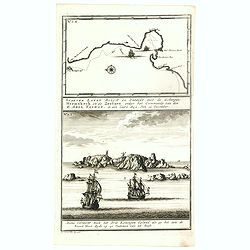
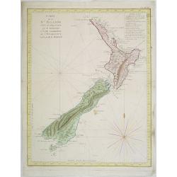
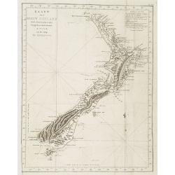
Staeten Landt Bezylt en Ontdekt met de Scheepen Heemskerk en de Zeehaen onder het Commande van den E. Abel Tasman. In den Iaare 1642. Den 13 December.
In the upper part an early map of Staten Landt depicting Tasman's voyage down the west coast of New Zealand in his ships Heemskerk and Zeehaen. The coast line in the Cook...
Place & Date: Amsterdam, 1726
Selling price: $2925
Sold in 2016
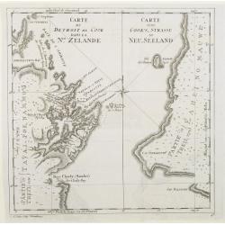
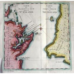
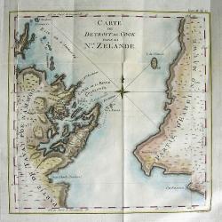
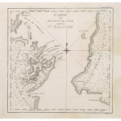
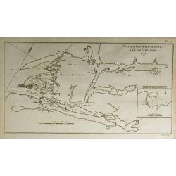
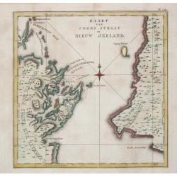
Carte du detroit de Cook dans la Nle. Zelande. Carte von Cook's-Strasse in Neu-Seeland
Showing Cook Strait in New Zealand. Engraved by D.A.Hauer.
Place & Date: Nuremberg, 1773
Selling price: $190
Sold
Carte du detroit de Cook dans La Nle. Zelande.
Very important map showing Cook's Strait, which separates the North and South islands of New Zealand. Present day Wellington, Marlborough Sounds, and Cloudy Bay are depic...
Place & Date: Nuremberg, c1773
Selling price: $200
Sold in 2010
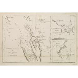
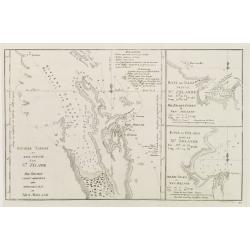
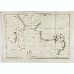
Riviere Tamise et Baye Mercure a la Nle. Zélande / Baye des Isles dans la Nle. Zelande / Baye de Tolaga dans la Nle. Zelande /Tome III Pl. 9.
Nautical map of the Tamise River and the Mercure and Tolaga Bay in New Zealand. This map is taken from the first French edition of James Cook's first voyage entitled Rel...
Place & Date: Paris, 1774
Selling price: $240
Sold in 2008
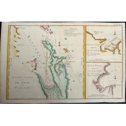
Riviere Tamise et Baye Mercure a la Nle. Zélande.
Baye des Isles dans la Nle. Zelande / Baye de Tolaga dans la Nle. Zelande /Tome III Pl. 9.. A nautical map of the Tamise River and the Mercure and Tolaga Bay in New Zeala...
Place & Date: Paris, 1774
Selling price: $190
Sold in 2019
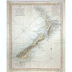
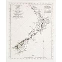
Carte de la Nle. Zelande vifitée en 1769 et 1770 par le Lieutenant J. Cook Commandant de l\'Endeavour. . . . Tome III Pl. 7.
Important map of New Zealand showing track of Cooks' Endeavour with relief shown by hachures and bathymetric soundings. The map is taken from the first French edition fr...
Place & Date: Paris, Saillant et Nyon, 1774
Selling price: $550
Sold in 2013
![[HAWAII] - Plan de la baye de Karakakooa.](/uploads/cache/48173-250x250.jpg)
[HAWAII] - Plan de la baye de Karakakooa.
Beautiful map showing the islands forming the Hawaiian archipelago, drawn up during Cook's third voyage: Oneeheow or Ni'ihau, Atooi or Kauai, Woahoo or O'ahu, Morotoi or ...
Place & Date: Paris, 1774
Selling price: $425
Sold in 2022
Carte de la Nle. Zelande vifitée en 1769 et 1770 par le Lieutenant J. Cook Commandant de l\'Endeavour. . . . Tome III Pl. 7.
Important map of New Zealand showing track of Cooks\' Endeavour with relief shown by hachures and bathymetric soundings. The map is taken from the first French edition f...
Place & Date: Paris, Saillant et Nyon, 1774
Selling price: $1100
Sold in 2009
CARTE DU DETROIT DE COOK DANS LA Nle. ZELANDE
Very important map showing Cook\'s Strait, which separates the North and South islands of New Zealand. Present day Wellington, Marlborough Sounds, and Cloudy Bay are depi...
Place & Date: Paris, 1774
Selling price: $280
Sold in 2008
Carte du Detroit de Cook dans la Nle. Zelande. Tome III Pl. 11.
The map depicts Cook\'s Strait, that separates the north and south island of New Zealand. Present day Wellington (NZ\'s capital), Marlborough Sounds, and Cloudy Bay (famo...
Place & Date: Paris, 1774
Selling price: $425
Sold in 2008
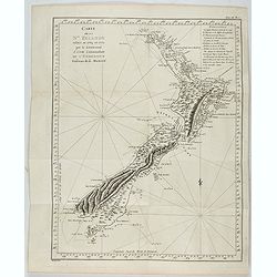
Carte de la Nouvelle-Zelande visitée en 1769 et 1770 par le Lieutenant J. Cook..
Map of New Zealand, engraved by Bernard. The Dutchman Abel Tasman discovered New Zealand in 1642: however it was Cook's circumnavigation of the Islands in 1769 & 1770...
Place & Date: 1774
Selling price: $1900
Sold
Carte de la Nouvelle-Zelande visitée en 1769 et 1770 par le Lieutenant J. Cook.
Original French Edition of James Cook's Chart of New Zealand, from the First French Edition of Hawkesworth's Voyages. Map of New Zealand, engraved by Bernard. The most im...
Place & Date: Paris, 1774
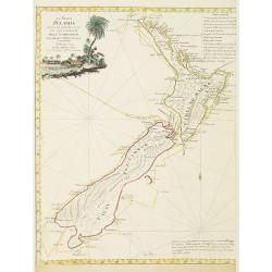
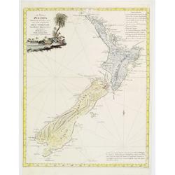
La Nuova Zelanda tracorsa nel 1769 e 1770 dal Cook commandante dell' Endeavour Vascello di S.M.Britannica.
Antonio Zatta?s map of New Zealand is not only one of the first to show the results of Cook?s voyages, but is also one of the most attractive of the islands. Considerable...
Place & Date: Venise, 1778
Selling price: $1750
Sold in 2008
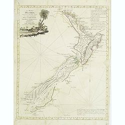
La Nuova Zelanda tracorsa nel 1769 e 1770 dal Cook commandante dell' Endeavour Vascello di S.M.Britannica.
Antonio Zatta?s map of New Zealand is not only one of the first to show the results of Cook?s voyages, but is also one of the most attractive of the islands. Considerable...
Place & Date: Venise 1778
Selling price: $2650
Sold
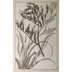
Plante de Lin de la Nouvelle Zélande.
From the French edition of James Cook's second voyage entitled Voyage dans l'Hémisphère Austral, et autour du Monde, fait sur les Vaissseaux de Roi, l'Aventure, la Rés...
Place & Date: Paris, 1778
Selling price: $30
Sold in 2010
Plan de le Baye Dusky (Obscure) à la Nouv-e. Zélande.
From the French edition of James Cook's second voyage entitled Voyage dans l'Hémisphère Austral, et autour du Monde, fait sur les Vaissseaux de Roi, l'Aventure, la Rés...
Place & Date: Paris, 1778
Selling price: $40
Sold in 2010
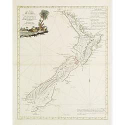
La Nuova Zelanda tracorsa nel 1769 e 1770 dal Cook commandante dell' Endeavour Vascello di S.M.Britannica.
Antonio Zatta?s map of New Zealand is not only one of the first to show the results of Cook?s voyages, but is also one of the most attractive of the islands. Considerable...
Place & Date: Venise 1778
Selling price: $1100
Sold
La Nuova Zelanda tracorsa nel 1769 e 1770 dal Cook commandante dell' Endeavour Vascello di S.M.Britannica.
Antonio Zatta’s map of New Zealand is not only one of the first to show the results of Cook’s voyages, but is also one of the most attractive of the islands. Consider...
Place & Date: Venise, 1778
Selling price: $900
Sold in 2013
Riviere Tamise et Baye Mercure à la Nle. Zelande ..
A detailed chart after Cook?s charting of Mercury Bay and the Hauraki Bay at Auckland, New Zealand with soundings anchorages and other navigational data, with two insets ...
Place & Date: Germany, c. 1780
Selling price: $180
Sold
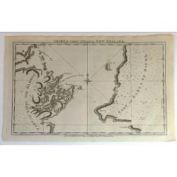
Chart of Cook's Strait in New Zealand.
Fine copperplate map of Captain Cook's discovery of New Zealand on hos first voyage of 1768. In 1770 he entered a deep water inlet and named it Queen Charlotte Sound and ...
Place & Date: London, 1785
Selling price: $161
Sold in 2015
Carte de l'Entrée de Norton, et du Detroit de Bhering ou Von vou le Cap le plus oriental de l'Asie, et la Pointe la plus occidentale de l'Amerique.
Early detailed map of the passage between Asia and the NW Coast of America, including nice topographical details and the day by day tracks of Cook through the region in 1...
- $300 / ≈ €281
Place & Date: Paris, 1785
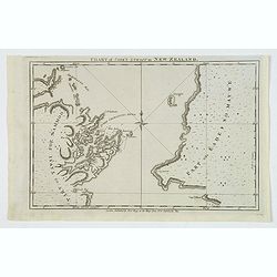
Chart of Cook's Strait in New Zealand.
An early and important map of Cook's Strait, which separates the North and South islands of New Zealand. Shows the area of present day Wellington, Marlborough Sounds, and...
Place & Date: London, 1785
Selling price: $75
Sold in 2019
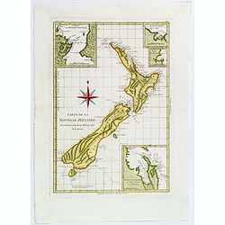
Carte de la Nouvelle Zéelande.
Rigobert Bonne's map appears in his Atlas Encylopedique. It is the best known printed summary of all Cook's maps pertaining to Australia and New Zealand. Cook's circumnav...
Place & Date: Paris, 1788
Selling price: $395
Sold in 2018
Carte de la Nouvelle Zéelande.
Rigobert Bonne's map appears in his Atlas Encylopedique . It is the best known printed summary of all Cook's maps pertaining to Australia and New Zealand. Cook's circumna...
Place & Date: Paris, 1788
Selling price: $350
Sold in 2017

Chart of Cook's Strait in New Zealand.
An early and important map of Cook's Strait, which separates the North and South islands of New Zealand. Shows the area of present day Wellington, Marlborough Sounds, and...
Place & Date: London, ca. 1790
Selling price: $20
Sold in 2017
![[Lot of 6 maps / prints] Schets van de Donkere Baai in Nieuw Zeeland 1773.](/uploads/cache/20531-(1)-250x250.jpg)
[Lot of 6 maps / prints] Schets van de Donkere Baai in Nieuw Zeeland 1773.
A map of Dusky Bay, visited by James Cook in 1773. From a Dutch edition of ‘Cook's voyages'. Schets van de Donkere Baai in Nieuw Zeeland 1773. Nicolas Bellin's map of t...
Place & Date: London, c, 1790
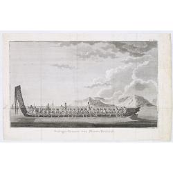
Oorlogs-Praauw van Niew-Zeeland
Shows long Maori war canoe with carved stern and prow, being rowed by about 30 men, with several men standing. Two further canoes with sails in the left background. Gable...
Place & Date: Amsterdam, 1795
Selling price: $50
Sold in 2013
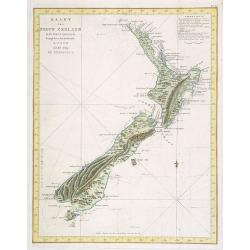
Kaart Van Nieuw Zeeland in de Jaaren 1769 en 1770 bezogt door den Luitenant J. Cook met het Schip De Endeavour.
A uncommon issue of this key map of New Zealand.From the Dutch edition of Prevost's "L'Histoire Générale des Voyages". From 1778 on printed editions of ' Capt...
Place & Date: Leiden, 1795-1803
Selling price: $1300
Sold in 2009
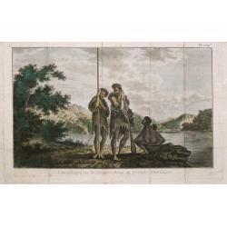
Inboorlingen van de Donkere-Baai op Nieuw-Zeeland.
Captain James Cook (1728-79), explorer, circumnavigator and hydrographer. Three voyages, 1768-71, 1772-75 and 1776-79. From 1778 on printed editions of ' Captain Cook's T...
Place & Date: Leiden, 1795-1803
Selling price: $60
Sold in 2019
Kaart Van Nieuw Zeeland in de Jaaren 1769 en 1770 bezogt door den Luitenant J. Cook met het Schip De Endeavour.
A uncommon map of New Zealand.From the Dutch edition of Prevost's "L'Histoire Générale des Voyages". From 1778 on printed editions...
Place & Date: Leiden, 1795-1803
Selling price: $1100
Sold in 2008
Kaart van Cooks Straat in Nieuw Zeeland.
Captain James Cook (1728-79), explorer, circumnavigator and hydrographer. Three voyages, 1768-71, 1772-75 and 1776-79. From 1778 on printed editions of \"Captain Coo...
Place & Date: Leiden, 1795-1803
Selling price: $225
Sold
![[Lot of 4] maps of the Pacific Ocean OCEANIE](/uploads/cache/19762-(1)-250x250.jpg)
[Lot of 4] maps of the Pacific Ocean OCEANIE
A map of the Pacific by Aristide Michel Perrot. [Lot of 4] maps of ARCHIPEL, NIEUW ZEELAND, OCEANIE + KANO tekening- Oceanie- Carter de L'Archipel de St Lazare ou le...
Place & Date: Paris, 1825
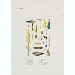
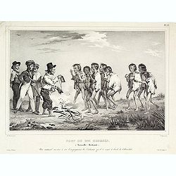
Nouvelle-Zélande.
Hand colored engraving of tools of locals of New Zealand. Engraved by Ambroise Tardieu after Chazal taken from the rare and important book " Voyage autour du Monde, ...
Place & Date: Paris, Arthus Bertrand, 1826
Selling price: $250
Sold in 2017
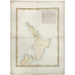
Nouvelle Zelande.
Detailed chart of the North Island of New Zealand, Cook Straits and part of the south Island, based upon the observations of the French expedition led by Dumont D'Urville...
Place & Date: Paris, 1827
Selling price: $205
Sold in 2019
![[ Portraits of New Zealand inhabitants ].](/uploads/cache/26370-250x250.jpg)
[ Portraits of New Zealand inhabitants ].
Aquatint depicting 4 portraits of New Zealand inhabitants engraved by Castelli. Plate N° 68. From Giulio Ferrario's work Le Costume Ancien et Moderne ou Histoire du gouv...
Place & Date: Milan, 1827
Selling price: $55
Sold in 2011
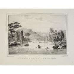
La vue du bassin de Norton sur le cours de la rivière Nepean (Nouvelle Galles méridionale).
Uncommon lithography by Langlumé showing River Nepean. From ALBUM PITTORESQUE DELA FRÉGATTE LA THÉTIS ET DE L''ESPÉRANCE. Collection de dessins relatifs à autour du ...
Place & Date: Paris, 1828
Selling price: $100
Sold in 2008
Port du roi Georges.
Depicting the discovery of New-Zealand by the Astrolabe.
Place & Date: ca.1830
Selling price: $210
Sold
Carte de la Nouvelle-Zélande pour servir au Voyage pittoresque autour du Monde
Dumont d'Urville was second in command on Duperrey's expedition of 1824 and later led his own expedition to the Pacific aboard the 'Astrolabe'. The 'Dictionary of Mapmake...
Place & Date: Paris: L.Tenré, 1835
Selling price: $300
Sold