Browse Listings in Atlases

La Géographie Universelle contenant.
Edition unknown to Pastoureau.
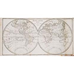
Place & Date: Paris, l'Auteur et Nicolas Langlois, 1682
Selling price: $80000
Sold
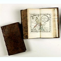
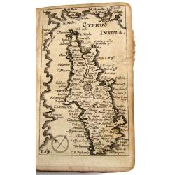
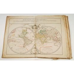
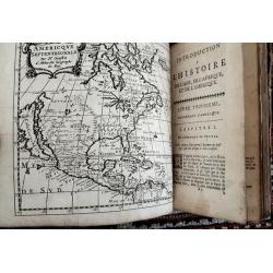
La Géographie Universelle contenant. Les Descriptions, les cartes, et le Blason, des principaux Païs du Monde.
Rare pocket atlas of the world by Pierre Duval with the maps in original outlines colors (except for the China map) and the coats-of-arms and titles-pages beautifully emb...
Place & Date: Paris, l'Auteur et Nicolas Langlois, 1682
Selling price: $2700
Sold in 2017
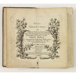
Atlas Terrestris: or a Book of Mapps of all the Empires, Monarchies, Kingdoms, Regions, . . . in the whole World.
One of a series of composite world atlases of varying contents published by John Seller (fl.1658-1698) from 1676 onwards and among one of the very earliest English world ...
Place & Date: London: John Seller, [no date] c. 1684
Selling price: $12000
Sold in 2010
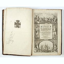
Le Grand & Nouveau Miroir ou Flambeau de la Mer..
A RARE EDITION of a French text edition of this fine Dutch Sea atlas of the West European waters with mostly plates originally engraved by Pieter Goos, who passed into th...
Place & Date: Amsterdam, J. Robijn, 1684
Selling price: $8900
Sold in 2015

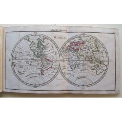
A tutor to Astronomy and Geography. Or an easie and speedy way to know the Use of both the Globes, Celestial and Terestrial. With an appendix shewing the Use of the Ptolemaick Sphere. The fourth edition...
A tutor to Astronomy and Geography. Or an easie and speedy way to know the Use of both the Globes, Celestial and Terestrial. With an appendix shewing the Use of the Ptole...
Place & Date: 4th edition, London, 1686
Selling price: $1000
Sold
Memoires, historiques & geographiques du Royaume de la Moree, Negrepont, & des places maritimes jusques à Thessalonique. Recueillis & enrichis des cartes des païs & des plas des places.
First French translation and first Dutch edition of Vincenzo Maria Coronelli's (1650-1718) history of Greece, one of the basic source works on the Peloponnesus.On both co...
Place & Date: Amsterdam, Wolfgang, Waesberge, Boom, Van Someren, 1686
Selling price: $6000
Sold
Kurtze Beschreibung von dem Ursprung, Aufnehmen, Gebiete und Regierung der Weltberühmten Republick Venedig.
Short description of the origin, recording, and government areas of the world-famous “Venice Republick.” The first and only edition of this rare work. The copper eng...
Place & Date: Nuremberg, 1686
Selling price: $1601
Sold in 2015
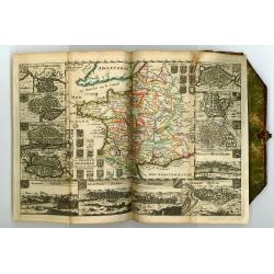
Description de tout l'univers, en plusieurs Cartes, et en divers Traittez de Géographie et d'Histoire...
Very rare edition of this popular atlas by Nicolas Sanson, published by Arnout van Ravestein, in Amsterdam, in 1699.Pastoureau only mentions a Dutch version of Sanson's a...
Place & Date: Amsterdam, Van Ravestein, 1699
Selling price: $2700
Sold in 2018
A System of Geography: or, a New & Accurate Description of the Earth in all its Empires, Kingdoms and States.
FIRST EDITION of Moll's important work with the title printed in red and black, 40 engraved maps, 2 full-page, small engraved map in text, 2 engraved solar diagrams. The...
Place & Date: London, for A. and J. Churchill, 1701
Selling price: $6700
Sold in 2014
Recueil des Voyages qui ont Servi a l'Etablissement et aux Progres de la Compagnie des Indes Orientales...
Very rare account of the Dutch voyages after Commelin. With title, 1 plate and 14 folding maps, including maps of Novaya Zemlya, Spitsbergen, Madagascar, St. Helena, Sout...
Place & Date: Amsterdam, 1702
Selling price: $700
Sold in 2013
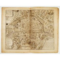
Atlas curieux Paris.
A fine series of 10 double page plans of Paris (c.450x530mm) showing the town's development during several ages. Prepared by Jean-Baptiste Bourguignon d' Anville,(1697-17...
Place & Date: Paris 1705
Selling price: $3750
Sold
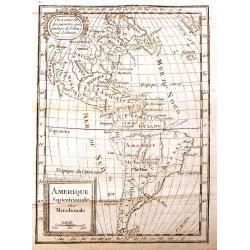
LES TABLETTES GUERRIERES, OU CARTES CHOISIES POUR LA COMMODITE DES OFFICIERS.
Most maps decorated with a borders showing town views and plans. The map of America with the island of California with an indented coastline and the place names R. d' Est...
Place & Date: Amsterdam, 1709
Selling price: $3100
Sold
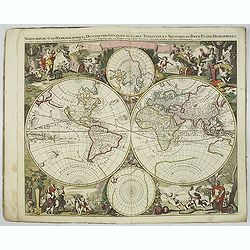
Nova totius geographica telluris projectio. . .
This is the first atlas of Gerard Valk, publisher, engraver and manufacturer of globes in Amsterdam. The latter joined in 1673 Petrus Schenck for the publication of maps....
Place & Date: Amsterdam, ca. 1711
Selling price: $16940
Sold in 2023
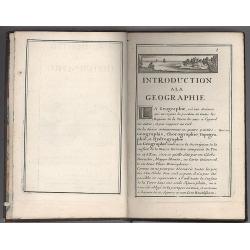
Introduction a la Geographie..
Second edition of this charming travel compendium. The title page illustrated with miniature world map in double hemisphere showing California as an island, with imprint ...
Place & Date: Paris, 1717
Selling price: $55
Sold in 2008
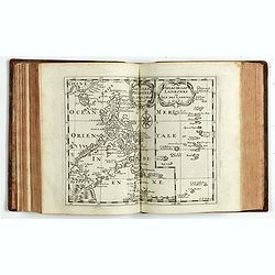
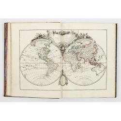
Atlas with 19 maps, 2 Family trees and 3 historical tables.
Atlas including a double hemisphere world map, maps of Europe, Asia, Africa, North America (engraved by Cordier, showing California as an Island, based upon Sanson's land...
Place & Date: Paris, 1719
Selling price: $4775
Sold

Le Nouveau et Curieux Atlas Geographique et historique, ou Le Divertissement des Empereurs, Roys, et Princes. Tant dans la Guerre que dans la Paix. Dédié A Son A.R. Monseigneur le Duc d'Orléans Regent du Roîaume de France.
Charming world atlas with double hemisphere world and the North American map feature the Island of California. In Asia and the Pacific, Australia is incompletely mapped a...
Place & Date: Paris, 1719
Habillemens de plusieurs nations représentez au naturel, en cent trente-sept belles figures.
Illustrated with a title page and 132 engraved plates of costumes (of 136) not following the numbering but grouped by countries.The plates showing various nations from al...
Place & Date: Leiden, Pierre van der Aa, c. 1720
Selling price: $1750
Sold in 2018
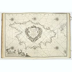
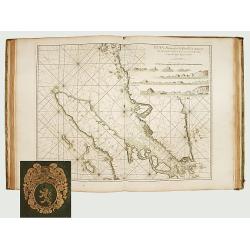
(Recueil de plans et ports de la Méditerranée).
Superb atlas of the Mediterranean containing 19 charts (including 1 double) engraved by Starckman, Coélemans, and B. Randon Hunting and mounted on heavy paper. Each char...
Place & Date: Marseille, Laurent Brémond,1715-1726
Selling price: $30000
Sold

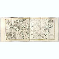
Discours sur l'histoire universelle..
Three volumes with 26 maps, including the World and Continents, Israel, Middle sea area, Russia, Scandinavia,Denmark, Iceland,Poland, Britain, England, Scotland,Ireland,N...
Place & Date: Amsterdam, 1730
Selling price: $1500
Sold
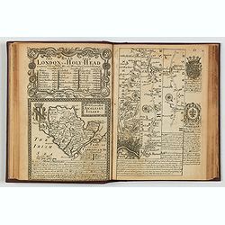
Britannia Depicta or Ogilby Improv'd. . .
A nice English atlas of reduced road maps from John Ogilby's earlier survey of 1675. Four editions and many reprints were published, the last in 1764. This example is a f...
Place & Date: London, ca 1730
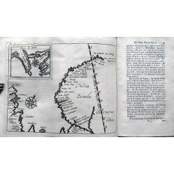
![[Recueil de Voyages au Nord].](/uploads/cache/48310-250x250.jpg)
[Recueil de Voyages au Nord].
Extract from volume III of the "Recueil de Voyages au Nord", containing the reports of Linschoten's voyages, the first to the North through the Strait of Nassau...
Place & Date: Amsterdam, Bernard, 1732
Selling price: $300
Sold in 2022
BRUZEN DE LA MARTINIERE: Introduction a l'histoire de l'Asie de l'Afrique et de l'Amérique.
Volume 2 (of 2) of his "Introduction a l'histoire de l'Asie de l'Afrique et de l'Amérique", complete with map of America, including a California as a island.Th...
Place & Date: Amsterdam, Zacharie Chatelain, 1735
Selling price: $335
Sold in 2021

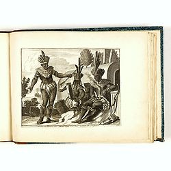
Avantures du Sr. C. Le Beau, avocat en parlement ou Voyage curieux et nouveau parmi les Sauvages de l'Amérique Septentrionale. Dans lequel on trouvera une Description du Canada… Ouvrage enrichi d'une Carte et des figures necessaires.
A description of Huron, Iroquois, and Algonquin customs, written in charming style and based, the Author claims, on observations made on a trip to America in 1729." ...
- $2500 / ≈ €2339
Place & Date: Amsterdam, 1738
![(Chatelain "Atlas Historique" in 7 volumes.]](/uploads/cache/47053X-250x250.jpg)
(Chatelain "Atlas Historique" in 7 volumes.]
Henri Abraham Chatelain, whose Atlas Historique was one of the most expansive encyclopedias of the age. First published in 1705, Chatelain's Atlas Historique was part o...
Place & Date: Amsterdam: Chez Zacharie Châtelain, 1732 - 1739
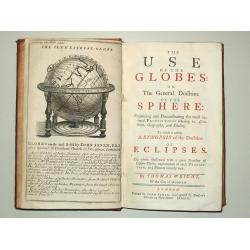
The Use of the Globes or The General Doctrine of the Sphere. To which is added a Synopsis of the Doctrine of Eclipses.
8vo, iv, 162, (2) p., old calf (slightly worn). With engr.front. and 29 fold. maps and plates.Plates includes advertisement of Senex' terrestrial and celestial globes, wo...
Place & Date: London, J.Senex, 1740
Selling price: $2050
Sold
Le Neptune Oriental ou Routier Général des Côtes des Indes Orientales et de la Chine...
First edition. - D'Après de Mannevillette (1707-1780) was a famous French sailor and hydrographer. During a voyage to China in 1728 he succeeded in correcting the latitu...
Place & Date: Paris, Jean-François Robustel, 1745
Selling price: $16100
Sold in 2011
Le Neptune Oriental ou routier general des Cotes des Indes orientales et de la Chine..
THE RARE FIRST EDITION of this important French Sea Atlas of the Red Sea, India, the East Indies, Indochina and Formosa.2° (640 x 490 mm). Title printed in red and b...
Place & Date: Paris, 1745
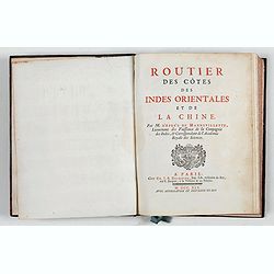
Routier des côtes des Indes orientales et de la Chine.
FIRST EDITION. This rare Pilot to the East Indies was published simultaneously to accompany the large "Neptune Oriental" atlas, which was one of the greatest ma...
Place & Date: Paris, Delespine, 1745
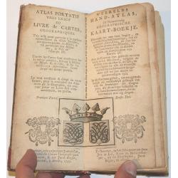
Atlas Portatif.
Small hand atlas of the world with 33 of 34 maps. Map nr. 4 (De Nieuwe en Ouden Oppervlakke en Doorzigtkundige Aardryks Bollen) is missing. The title page and register ar...
Place & Date: Almelo, 1747
Selling price: $1400
Sold in 2013
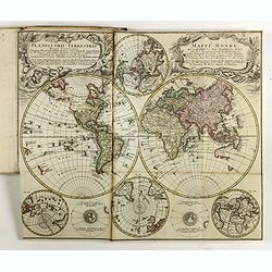
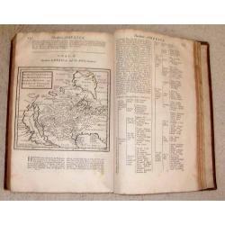
(Atlas with 23 maps by Homann)
Homann composite atlas including a double-hemispherical world map, continental maps of Europe, Africa and Asia, and region specific maps of most European countries, like ...
Place & Date: Nuremberg, 1748
Selling price: $2200
Sold in 2019
Atlas nouveau portatif à l'usage des militaires et du voyageur.
>Charming atlas with an engraved title, and 91 numbered and engraved double-page maps in orginal out line colors. The atlas starts by 36 pages text entitled 'Introduct...
Place & Date: Paris, Le Rouge, Prault, Veuve Robinot, Briasson, 1756
Selling price: $2300
Sold in 2022

Allgemeine Historie der Reisen zu Wasser und zu Lande: oder Sammlung aller Reisebeschreibungen, welche bis itzo in verschiedenen Sprachen von allen Volkernherausgegeben worden. . .
Collection of travel exploration of South and North America. With 19 copperengravings (10 folded maps). The maps of N. Bellin showing: (1) South-American continent, (2) G...
Place & Date: Leipzig, 1757
Selling price: $700
Sold in 2009
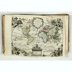
Dictionaire Géographique Universel, ou Description des Royaumes, Provinces, Villes... etc.
A very fine copy of Vosgien's geographical dictionary with a world map in two hemispheres and a map of Europe.
Place & Date: Paris, 1759
Selling price: $250
Sold in 2019
A New, General, and Universal Atlas...
Published by A. Dury, Robert Sayer & Carrington Bowles; oblong 12mo; engraved title, dedication plus 39 Copper Engraved Maps (Complete) Incl 6 folding. The folding ma...
Place & Date: London, 1761
Selling price: $1250
Sold in 2016
Atlas moderne ou collection de cartes sur toutes les parties du globe terrestre par plusieurs auteurs.
Typical 18th century French atlas, including maps by Janvier, Rizzi Zannoni and Bonne. Decorative title page: two women holding the title in a large drape, the page is fi...
Place & Date: Paris, Lattré, 1762
Selling price: $2700
Sold

Atlas Geographicus portatilis XXIX mappis orbis habitabilis regna exhibens ... Kurzgefasste Geographie
Pocket atlas of T. Lotter and T. Lobeck. Bound with "Kurzgefasste Geographie" of Lobeck. With one world map, one celestial map, 4 continents and 37 european map...
Place & Date: Augsburg, 1762
Selling price: $1600
Sold in 2010
Le Geographe Manuel, Contenant La Description de Tous les Pays du Monde.
Miniature Atlas in French featuring maps of The World, The Americas, Asia, Africa, Europe & France. Atlas is by Jean Joseph Georges Abbe d'Expilly who was a French di...
Place & Date: Paris, 1762
Selling price: $205
Sold in 2013
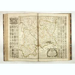
The Large English Atlas, or, a New Set of Maps of All the Counties of England and Wales.
FIRST EDITION. "The Large English Atlas" is the most important eighteenth-century English atlas to be published before the appearance of John Cary's new English...
Place & Date: Londen, T. Bowles, John Bowles and Robert Sayer, [n.d.] ca. 1762
Selling price: $4000
Sold in 2017
Les Revolutions de l'Univers.
First edition of this historical atlas presenting the political devisions of Eurasia from the dispersion of the Childern of Noah until the reunion of Lorraine to France....
Place & Date: Paris, Lattré, M CC. LXIII. [1763
Selling price: $3500
Sold in 2015
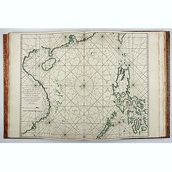
Receuil Des Principaux Plans des Ports.. Mer Mediterranee..
A good copy of this practical pilot book, clearly intended for use on shipboard. Containing 65 sea charts on heavy paper in black and white. Paper is crisp and impression...
Place & Date: Marseille 1764
Selling price: $2050
Sold