Browse Listings in Asia > Thailand / Burma / Vietnam
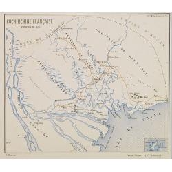
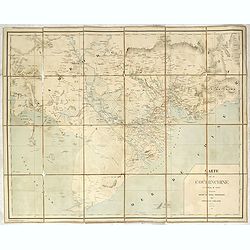
Cochinchine Française Expedition de 1858.
Map of Cochin china centered on Saigon and showing in red the French expedition of 1858. Published in "Atlas de Géographie Militaire adopté par M. le min. de la gu...
Date: Paris, Furne, Jouvet et Cie, 1875
Selling price: ????
Please login to see price!
Sold in 2008
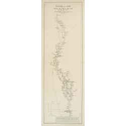
Royaume de Siam - Cours du Fleuve Me - Nam..
Detailed missionary map illustrating the course of the Menam [Chao Phraya] river in today Thailand. With short legend in the lower left corner.Engraved in stone by R. Hau...
Date: Paris 1878 - 1879
Selling price: ????
Please login to see price!
Sold
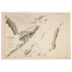
Mer de Chine. Golfe du Tonkin. Entrées de Kuaï-Chin-Mun et Tsieng-Mun. . .
Large chart centred on the Gulf of Tonkin in the South China Sea. Showing banks, isles and soundings made in metres. Relief is shown by hachures.Engraved by A. Gérin aft...
Date: Paris, 1887
Selling price: ????
Please login to see price!
Sold in 2008
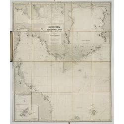
East India archipelago Western route to China, chart No.3.
Huge sailing of Gulf of Siam and South China Sea. Centering on Gulf of Siam, with a large inset of Gulf of Bangkok. Seven other insets, among, Saigon, River Bangkok, Pul...
Date: London, 1888
Selling price: ????
Please login to see price!
Sold in 2013
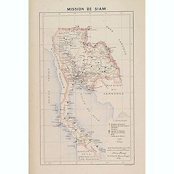
Mission de Siam.
Important map of Thailand, prepared by Adrien Launay, who was a French Missionary and later chronicer of the history of the French Missions in Indo-China at end of the 19...
Date: Lille, 1890
Selling price: ????
Please login to see price!
Sold
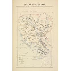
Mission du Cambodge.
Important missionary map showing Cambodia, prepared by Adrien Launay, who was a French Missionary and later chronicler of the history of the French Missions in Indo-China...
Date: Lille, 1890
Selling price: ????
Please login to see price!
Sold in 2015
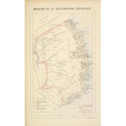
Mission de Cochinchine orientale.
Important missionary map showing central part of Vietnam, prepared by Adrien Launay, who was a French Missionary and later chronicler of the history of the French Mission...
Date: Lille, 1890
Selling price: ????
Please login to see price!
Sold in 2016
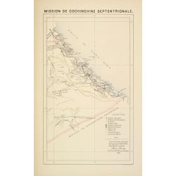
Mission de Cochinchine septentrionale.
Important missionary map showing part of Vietnam, prepared by Adrien Launay, who was a French Missionary and later chronicler of the history of the French Missions in Ind...
Date: Lille, 1890
Selling price: ????
Please login to see price!
Sold in 2016
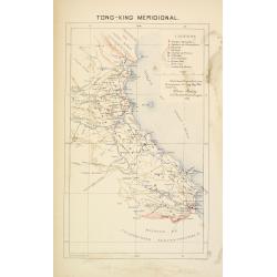
Tong-King Méridional.
Important missionary map showing part of Vietnam, prepared by Adrien Launay, who was a French Missionary and later chronicler of the history of the French Missions in Ind...
Date: Lille, 1890
Selling price: ????
Please login to see price!
Sold in 2016
Carte de la Cochinchine.
Uncommon map of Cochin chine, prepared by captain Friquegnon. Printed in Hanoï by F.H.Schneider.
Date: Hanoï, 1890
Selling price: ????
Please login to see price!
Sold in 2019
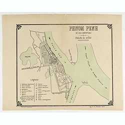
Plan Phnom Penh et ses environs.
Early French map of Phnom Penh and its surroundings. Printed by. F. H. Schneider in Hanoi. Recruited as an agent at the colonial printing press in Saigon in 1882, he was ...
Date: Hanoï, ca. 1890
Selling price: ????
Please login to see price!
Sold in 2020
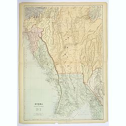
Burma and adjacent countries.
A large color printed map of Burma and her neighboring countries.
Date: London, 1894
Selling price: ????
Please login to see price!
Sold in 2018
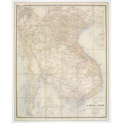
Carte de L'Indo-Chine Dressée sous les auspices des Ministres des affaires étrangéres & des colonies..
Large folding, so-called case-map showing Indo China and part of Thailand.Printed in color lithography by Dufrénov in Paris. The map is engraved on stone by Poulmaire.Wi...
Date: Paris, 1895
Selling price: ????
Please login to see price!
Sold
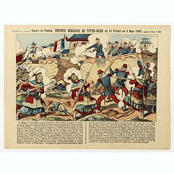
Guerre du Tonkin. Défense héroïque de Tuyen-Quan, du 14 février au 3 mars 1885. (N°165)
Broad sheet relating to The Siege of Tuyen Quang which was an important confrontation between the French and the Chinese armies in Tonkin (northern Vietnam) during the Si...
Date: Epinal, ca. 1900
Selling price: ????
Please login to see price!
Sold in 2019
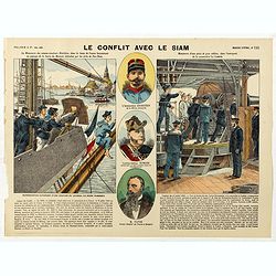
Le conflit avec le siam. (N°195)
Broad sheet relating to the Franco-Siamese War of 1893, a conflict between the French Third Republic and the Kingdom of Siam. Auguste Pavie, French vice consul in Luang P...
Date: Epinal, ca. 1900
Selling price: ????
Please login to see price!
Sold in 2026
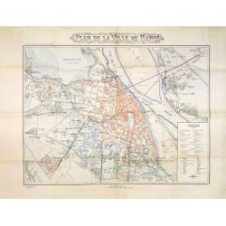
Plan de la ville de Hanoi.
Rare and detailed plan of Hanoi, scale 1:10.000. The plan was published at the occasion The Exhibition of Hanoi which opening its doors on November 3, 1902. The exhibitio...
Date: Hanoi, November 1902
Selling price: ????
Please login to see price!
Sold in 2013
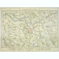
Environs de Hanoi.
Detailed map of Hanoi and its viccinities, scale 1:50.000. Published by the Service geographique de l'Indochine and prepared by Commander Friquegnon.The French Dutreuil d...
Date: Hanoi, 1904
Selling price: ????
Please login to see price!
Sold in 2011
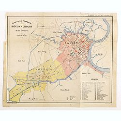
Indo-Chine Française Saïgon - Cholon et ses Environs
Charming plan of Saïgon at a scale of 1:40.000. Vietnam was a French colony from 1862 to 1954.Prepared by R.Brissaud and published in P.Alinot, Petit Atlas de la Cochinc...
Date: Saigon, Librairie Brunet. c.1920
Selling price: ????
Please login to see price!
Sold in 2020
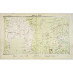
Carte de l''Indochine, feuille n°13: Bang-Kok.
Large scale map (1:500,000) centered on Bang Kok. Prepared by Lieutenant Colonel Dubuisson, head of the "Service Géographique de l'Indochine". With a color key...
Date: Hanoï, 1923
Selling price: ????
Please login to see price!
Sold in 2013
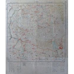
Burma
Curious large-scale map of Amherst & Thaton districts in Burma. Shows the area around Kamkareik with many place names, rivers, topographical features, etc. The Legend...
Date: 1925
Selling price: ????
Please login to see price!
Sold in 2012
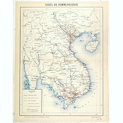
Voies de communication.
The map is published by the Service geographique de l'Indochine.The Frenchman Jules-Léon Dutreuil de Rhins produced at the end of the 19th century a general map of Indoc...
Date: Hanoi, November 1927
Selling price: ????
Please login to see price!
Sold in 2016
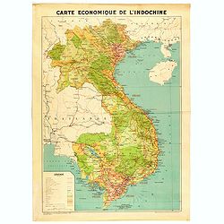
Carte économique de l'Indochine.
Large and uncommon economic map of Indochina published in 1937 by the "Service Géographique de l'Indochine" and printed by the "Service Géographique Nati...
Date: Hanoï, 1937
Selling price: ????
Please login to see price!
Sold in 2020
![[Phuket - Harbour]](/uploads/cache/48535-250x250.jpg)
[Phuket - Harbour]
Scarce Japanese chart of Phuket prepared by Daisuke Soejima Daikin and probably the first detailed chart of the region made just after the capture of Thailand by the Japa...
Date: Japan, August 1942
Selling price: ????
Please login to see price!
Sold in 2023
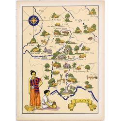
LAOS Région Nord.
Very decorative, informative map of the northern region of Laos. With a compass rose in upper left corner, the map is filled with buildings, animals, figures and two loca...
Date: France, 1943
Selling price: ????
Please login to see price!
Sold in 2010
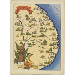
LAOS ANNAN Région Sud.
Very decorative, informative map of the region of Laos and Annan. The map is filled with buildings, animals, figures and two locals in their typical dress.In lower left c...
Date: France, 1943
Selling price: ????
Please login to see price!
Sold in 2010
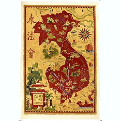
Indochine Française.
Poster in the form of a pictorial map showing Vietnam, Indochina in red on yellow, showing Hanoi, Pnom Penh. Designed by Lucien Boucher (1889–1971) for "l'associat...
Date: Paris, Perceval, ca. 1945
Selling price: ????
Please login to see price!
Sold in 2019
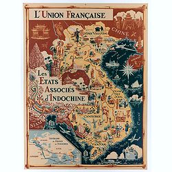
L'Union Française - Les Etats Associés d'Indochine.
Original chromo lithographed poster showing Laos, Vietnam, Cambodia and Indochina, published ca. 1948 for "Les Etats Associés d'Indochine Affaire ".Pictorial p...
Date: Paris, 1948
Selling price: ????
Please login to see price!
Sold in 2020
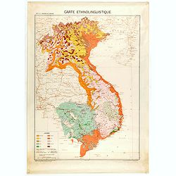
Carte de l'Indochine au 1 : 2.000.000. Carte ethnolinguistique.
Map showing Vietnam, Cambodia, and Laos, prepared under the direction of "l'Ecole Française d'Extrême-Orient". Relief shown by spot heights. With a colored ke...
Date: Hanoï, 1949
Selling price: ????
Please login to see price!
Sold in 2025
Ville Saigon edité par Havas Extréme Orient.
Decorative publicity plan of Ho Chi Minh City, also known by its former name of Saigon, Vietnam, surrounded by advertisements of local stores. In the center the "Jar...
Date: Paris, 1950
Selling price: ????
Please login to see price!
Sold in 2019
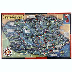
Guerre d'Indochine le Tonkin.
Pictorial map of Tonkin drawn by R. Forgues. on the verso information's about Indochina.More about Pictorial Maps [+]
Date: France, ca. 1950
Selling price: ????
Please login to see price!
Sold in 2020
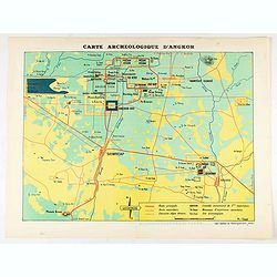
Carte Archeologique D'Angkor.
colorful tourist map centered on Angkor Vat, including its surroundings.
Date: ca. 1950
Selling price: ????
Please login to see price!
Sold in 2020
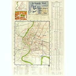
Bangkok Map in the 5th Asian Games year 1966.
A rare early map (460 x 370mm.) for the Siamese capital, shows the roads in red, railroads in blue and waterways, as well as points of interest. An exhaustive key notes t...
Date: Bangkok, 1966
Selling price: ????
Please login to see price!
Sold in 2018
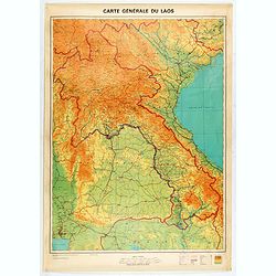
Carte générale du Laos.
General map of Laos published in 1968 by the "Service Géographique National du Laos", showing international and province boundaries, transportation, water feat...
Date: [Vientiane] , 1968
Selling price: ????
Please login to see price!
Sold in 2020
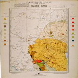
Carte geologique de l'Indochine. Bang-Kok est.
Geological or soil map showing part of Bangkok , including in the left and right margins a colored legend with signs of the different geological ages. Heliography and pri...
Date: Service geographique de l'Indochine, fevrier 1939.
Selling price: ????
Please login to see price!
Sold in 2009
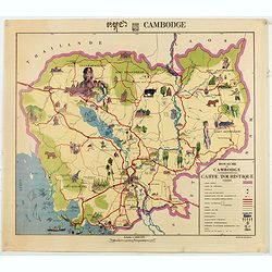
Royaume du Cambodge, carte touristique.
Decorative pictorial and Tourist map with points of interest shown pictorially. Figures monuments, animals, and beaches. Scale 1:1,000,000. Tite in upper margin, key at l...
Date: [Phnom Penh, Service ge´ographique des F.A.N.K., 1968]
Selling price: ????
Please login to see price!
Sold in 2020
