Browse Listings in Asia > South East Asia > South East Asia general
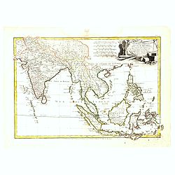
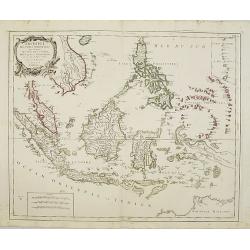
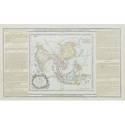
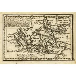
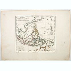
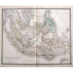
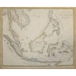
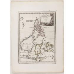
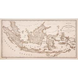
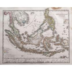
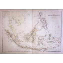
Les Indes Orientales et leur Archipel. . .
General map of Indonesia, extending from India to the Philippines and New Guinea.Ornated with a decorative title cartouche. Boundaries outlined in hand color.From theAtla...
Place & Date: Paris, ca 1783
Selling price: $135
Sold in 2016
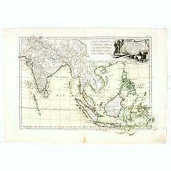
Les Indes Orientales et leur Archipel. . .
General map of Indonesia, extending from India to the Philippines and New Guinea.Ornated with a decorative title cartouche. Boundaries outlined in hand color.From theAtla...
Place & Date: Paris, ca 1783
Selling price: $220
Sold in 2017
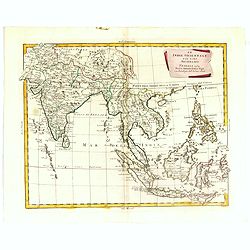
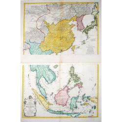
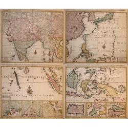
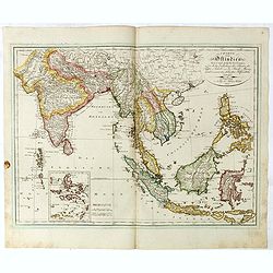
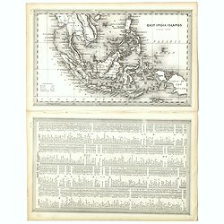
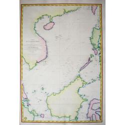
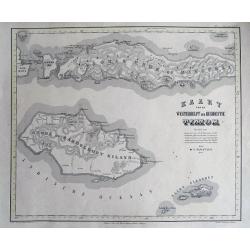
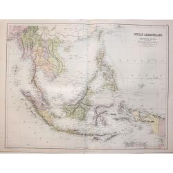
![[4 maps] Carte Hydro-Geo-Graphique des Indes Orientales en deça et au dela du Gange avec leur Archipel.. .](/uploads/cache/38416-250x250.jpg)
[4 maps] Carte Hydro-Geo-Graphique des Indes Orientales en deça et au dela du Gange avec leur Archipel.. .
A 4 sheet map south and east Asia, from Afghanistan in the west, across to China in the east, from the southern tip of the Indian peninsular and Ceylon (Sri Lanka) across...
Place & Date: Paris, ca. 1783
Selling price: $225
Sold in 2016
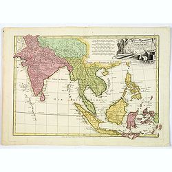
Les Indes Orientales et leur Archipel. . .
General map of Indonesia, extending from India to the Philippines and New Guinea.Ornated with a decorative title cartouche. Boundaries outlined in hand color.From theAtla...
Place & Date: Paris, ca 1783
Selling price: $100
Sold in 2018
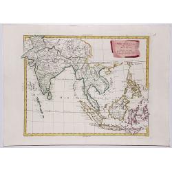
![[4 maps] Carte Hydro-Geo-Graphique des Indes Orientales en deça et au dela du Gange avec leur Archipel.. .](/uploads/cache/42474-250x250.jpg)
[4 maps] Carte Hydro-Geo-Graphique des Indes Orientales en deça et au dela du Gange avec leur Archipel.. .
A 4 sheet map south and east Asia, from Afghanistan in the west, across to China in the east, from the southern tip of the Indian peninsular and Ceylon (Sri Lanka) across...
Place & Date: Paris, ca. 1783
Selling price: $160
Sold in 2019
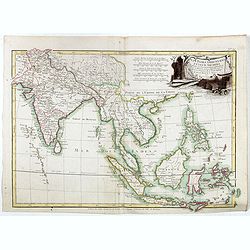
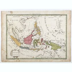
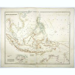
Les Indes Orientales et leur Archipel. . .
A good general map of Indonesia, extending from India to the Philippines and New Guinea.Decorated with a delightful title cartouche. Countries in hand color.From theAtlas...
Place & Date: Paris, ca 1783
Selling price: $95
Sold in 2020
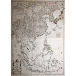
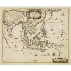
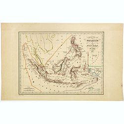
Archipel des Indes Orientales, qui comprend les Isles de la Sonde, Moluques et Philippines, tirées des cartes du Neptune Oriental..
Finely and crisply engraved map of the Malay Archipelago, including the Philippines south to the northern coast of Australia. Decorated with an ornamental title cartouche...
Place & Date: Venice, 1776 - 1784
Selling price: $650
Sold
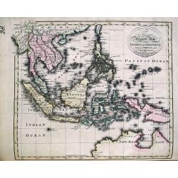
Le Indie Orientali E Il Loro Arcipelago . . .
Striking map of the region from the Gulf of Bengal to Hainan, centered on the Malay Peninsula, Straits of Malacca, Sumatra, Java and Philippines.The map was issued in Zat...
Place & Date: Venise, 1784
Selling price: $250
Sold in 2018
LE INDIE ORIENTALI E IL LORO ARCIPELAGO.
A striking regional map, extending from the Phillipines and Moluccas to India and the Maldives, and north to Tibet. Decorative scroll title cartouche.From Zatta's monumen...
Place & Date: Venise, 1784
Selling price: $230
Sold in 2017
Indie Orientali di Quà e di la Dal Gange col Loro Arcipelago.
Fine almost wall sized map of South east Asia, including Formosa, New Guinea, the Maldives and the Indus delta. From his "Atlante Novissimo, illustrato ed accresciut...
Place & Date: Venice, ca. 1779 - 1785
Selling price: $800
Sold in 2013
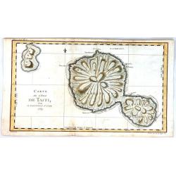
Carte de l'isle de Tahiti.
This chart of the islands of Tahiti is from James Cook’s first voyage, and is one of the earliest depicting the island.It is engraved to show the islands unique mountai...
Place & Date: London, 1785
Selling price: $100
Sold in 2017
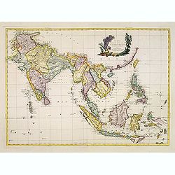
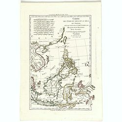
Zweiter Theil der Karte von Asien, welcher China, einen Theil der Taterei, Indien jenseits des Ganges, die Inseln Sumatra, Iava, Borneo, Moluken, Philippinen, und Iapon enthaelt.
In common large map of South East Asia, printed from 2 plates on 2 sheets joined, after d'Anville and other sources by F.A. Schraembl, Vienna "1786".
Place & Date: Vienna, after 1786
Selling price: $950
Sold in 2013
Zweiter Theil der Karte von Asien welcher China, einen Theil der Tartarei, Indien jenseits des Ganges, die Inseln Sumatra, Java . .
Two maps together depicting South East Asia / Zweiter Theil der Karte von Asien welcher China, einen Theil der Tartarei, Indien jenseits des Ganges, die Inseln Sumatra, ...
Place & Date: Wien, 1786
Selling price: $725
Sold in 2021
Carte des Isles des Amis
A finely engraved chart depicting the Friendly Islands, including the Kingdom of Tonga.The islands were discovered by Captain Cook, and his passage aboard the Resolution ...
Place & Date: Paris, 1788
Selling price: $30
Sold in 2021
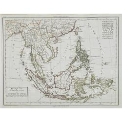
Chine, et Indes Avec les Isles avec les Isles, d'après les descriptions les plus exactes . . . 1790.
Attractive map of southern Asia, most of the East Indies, including China, Malaysia, Java, Borneo and the Philippines.Extending westwards to include India, the northern r...
Place & Date: Paris, 1790
Selling price: $150
Sold in 2018
Carte Generale des Indes Orientales..
Uncommon map of South East Asia based on Jansson's map of 1641, with good detail on Philippines. Showing Taiwan and the Southern part of Japan. Many Dutch names especiall...
Place & Date: Paris, 1790
Selling price: $1000
Sold in 2011
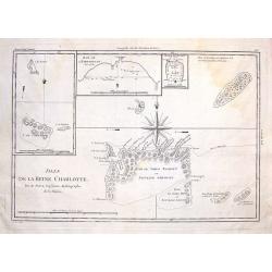
Isles de la Reine Charlotte.
These are the Santa Cruz Islands now, near the Solomon Islands. There are three inserts including the islands of Carteret, Hirondelle and bay of Byron. The centered overs...
Place & Date: Paris, 1790
Selling price: $3
Sold in 2014
Carte des Indes en Deca et au Dela du Gange, avec les Isles de la Sonde, Borneo, les Moluqes et les Philippines partie Orientale. Par M. Bonne, ingenieur Hydrographe de la Marine. A' Venise, Par P. Santini 1790.
A copper engraved map, prepared by R. Bonne and L'Abbe Grenet from "Atlas portatif a l'usage des colleges, pour servir a l'intelligence des auteurs classiques. Par M...
Place & Date: Venice, 1790
Selling price: $150
Sold in 2018
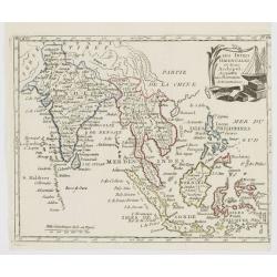
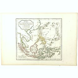
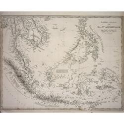
Partie de la Nouvelle Grande Carte des Indes Orientales.. 4 parts
Decorative and complete set of four scarce maps detailing all of Southeast Asia, filled with meticulous topography and place names.1) Partie de la Nouvelle Grande Carte d...
Place & Date: Amsterdam, 1792
Selling price: $1500
Sold in 2010
![[Wall map in 4 sheets] Partie de la nouvelle grande carte des Indes Orientales. . .](/uploads/cache/01041-250x250.jpg)
[Wall map in 4 sheets] Partie de la nouvelle grande carte des Indes Orientales. . .
Decorative and complete set of four scarce maps here in its first edition detailing all of Southeast Asia, filled with meticulous topography and place names.1) Partie de ...
Place & Date: Amsterdam, 1792
Selling price: $5200
Sold in 2010
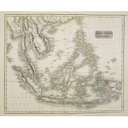
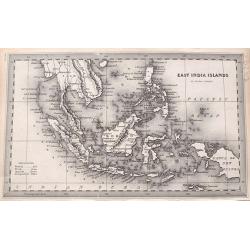
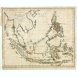
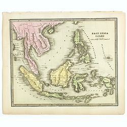
East India Islands.
Uncommon miniature map from Gibson's "Atlas Minimus, or a New Set of Pocket Maps of the several Empires, Kingdoms and States of the known World".
Place & Date: London, 1792
Selling price: $45
Sold in 2011
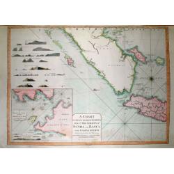
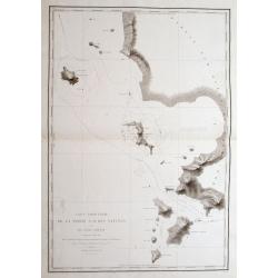
A Chart of the South Part of Sumatra and of the Straits of Sunda and Banca with Gaspar Straits...
SCARCE nautical from "The country East-India Pilot" published in 1799 by Laurie & Whittle. Large copper engraved map displaying parts of Sumatra and Java. ...
Place & Date: London, 1794
Selling price: $156
Sold in 2011
Presqu\'Île au dela du Gange et Archipel de l\'Inde.
Detailed map of Indonesia.
Place & Date: Paris, ca 1795
Selling price: $60
Sold in 2008
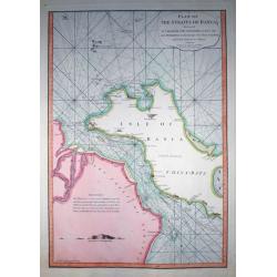
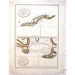
Plan of the Straits of Banca...
Rare nautical from "The country East-India Pilot" published in 1799 by Laurie & Whittle.A fantastic copper engraved map of Isle of Banca and part of Sumatr...
Place & Date: London, 1796
Selling price: $111
Sold in 2011
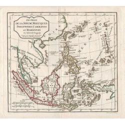
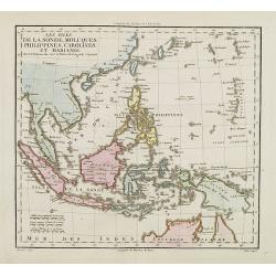
Les Isles de la Sonde, Moluques, Philippines, Carolines, et Mariannes.
Map of East Asia and Indonesia.
Place & Date: Paris, 1796
Selling price: $80
Sold in 2011
Le Indie Orientali E Il Loro Arcipelago . . .
Striking map of the region from the Gulf of Bengal to Hainan, centered on the Malay Peninsula, Straits of Malacca, Sumatra, Java and Philippines.This is the uncommon edit...
Place & Date: Venise, 1794-1796
Selling price: $450
Sold in 2017
Plan D'une Partie de l'Isle de Maouna & Plan de L'Anse du Massacre.
Two chart maps on one page featuring areas of Anerican Samoa. It is from "ATLAS DU VOYAGE DE LA PEROUSE". Perouse set sail from France in 1785 to continue the d...
Place & Date: Paris, 1797
Selling price: $15
Sold in 2017
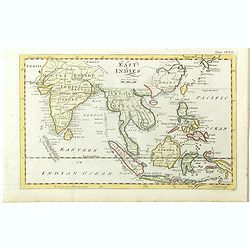
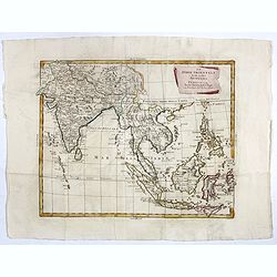
East Indies.
A lovely little late nineteenth century copperplate map of the East Indies. Showing India, Burma, Thailand, Cambodia, Laos, Malaysia, Indonesia, Borneo, Papua New Guinea,...
Place & Date: London, ca. 1797
Selling price: $100
Sold in 2018
Les Indes Orientales et leur Archipel..
Map of South Eastern Asia, encompassing the area between India and Indonesia.From Atlas de la Géographie de toutes les parties du monde .. Ouvrage destiné pour l\'educa...
Place & Date: Paris, Prudhomme, Levrault, Debray, 1806
Selling price: $100
Sold in 2008
Les Isles de la Sonde, Moluques, Philippines, Carolines et Marianes.
Map of South East Asia. By C. F. Delamarche, successor of Robert de Vaugondy, Geographer.
Place & Date: Paris, 1794 - 1806
Selling price: $100
Sold in 2014
Les Isles de la Sonde, Moluques, Philippines, Carolines et Marianes Par Robert de Vaugondy.
Map of South East Asia. from the atlas Nouvel Atlas Portatif destiné principalement à la jeunesse d'après la Géographie Moderne de l'Abbé Delacroix, published by Fel...
Place & Date: Paris, 1794 - 1806
Selling price: $100
Sold in 2018
Les Isles de la Sonde, Moluques, Philippines, Carolines et Marianes.
A precise map of South East Asia by C. F. Delamarche, successor of Robert de Vaugondy. Map extends from Taiwan to the northern reaches of Australia, covering Borneo, Mala...
Place & Date: Paris, 1794 - 1806
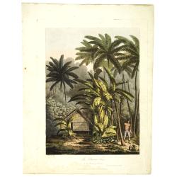
The plantain tree, in the island of Cracatoa.
The plantain tree, in the island of Cracatoa, taken from "Views in the South Seas" being a very important and early views depicting scenes encountered while emp...
Place & Date: London, Boydell and Co., 1808
Selling price: $1500
Sold in 2010
A New and Accurate Map of the Islands and Channels between China and New Holland.
Very rare copper-engraved map from Thomas Brown's General Atlas (1801 or 1808). The map extends from Burma to Taiwan with parts of China, and south to Australia, includin...
Place & Date: Edinburgh, 1801-1808
Selling price: $450
Sold in 2015

A new map of the East India Islands from the latest authorities. . .
Detailed map of the Indonesia , including the Malay Peninsula, engraved and published by John Cary. With excellent and geographically depicted detail. The original hand c...
Place & Date: London, 1811
Selling price: $380
Sold in 2011
Océanique Occidentale.
Showing Indonesia, with good detail on the Philippines. Engraved by Chamouin and prepared by Giraldon. Nice title, cartouche with octopus sea creatures.From Conrad Malte-...
Place & Date: Paris, 1809/1812
Selling price: $100
Sold in 2018
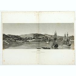
Timor. Vue de la rade, de la ville et du fort de Coupang, dans l'île de Timor.
Nice double page view of the town Kupang, formerly known as Koepang. In the center is the Dutch V.O.C. fort. From Voyage de découvertes aux terres Australes by François...
- $200 / ≈ €187
Place & Date: Paris, 1807-1816
East India Isles.
Somewhat later but very finely engraved and detailed map of the Indonesian archipelago, including Thailand, Philippines and southern part of Taiwan.
Place & Date: Edinburgh 1817
Selling price: $350
Sold
Ostindien.
Nice map of South East Asia published by Johannes Walch. Lower left inset map of the Moluccas and good detail on the Philippines.Johann Walch (1757-1824) was cartographer...
Place & Date: Augsburg, 1820
Selling price: $425
Sold in 2019
![Timor. Canda, jeune fille Malaise. [plate XXVI]](/uploads/cache/40115-250x250.jpg)
Timor. Canda, jeune fille Malaise. [plate XXVI]
Nicely colored portrait of a young Malay girl in Timor, carrying water.After the original sketches by Lesueur, from Voyage de découvertes aux terres Australes by Franço...
Place & Date: Paris, 1824
Selling price: $150
Sold in 2019
![[ Bangka inhabitants ].](/uploads/cache/25840-250x250.jpg)
[ Bangka inhabitants ].
Aquatint depicting two Bangka Island inhabitants (near Sumatra) engraved by D.K. Bonatti, after drawings by C. Bottigella. Plate N°49 From Giulio Ferrario's work Le Cost...
Place & Date: Milan, 1827
Selling price: $40
Sold in 2013
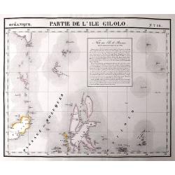
Partie de L'Ile Gilolo.
An important map of the area between Sulawesi, Mindanao, and Gilolo. Gilolo is today known as Halmahera, part of the Moluccas. The map also shows the important city of Te...
Place & Date: Brussels, 1827
Selling price: $80
Sold in 2017
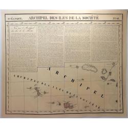
Archipel des Iles de la Societe. No. 42.
A map of the Society Islands, with a text block dealing with the area. The Society Islands includes a group of islands in the South Pacific Ocean. It is, politically and ...
Place & Date: Brusselles, 1827
Selling price: $17
Sold in 2019
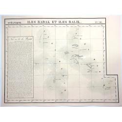
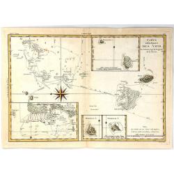
Iles Radak et Iles Ralik. No.16.
A hand colored, lithographed, large format map of Ralik and Radak, individual islands of the Marshall Islands. The map provides good topographic details and is included i...
Place & Date: Brusselles, 1827
Selling price: $13
Sold in 2021
![[Dutch soldiers in Indonesia].](/uploads/cache/14501-250x250.jpg)
[Dutch soldiers in Indonesia].
A decorative print showing a group of Dutch soldiers and 2 locals returning to their vessel. After design of A. van Eschen. From a series Hö:llandischer Dienst. 1...
Place & Date: Germany c.1830
Selling price: $20
Sold
EAST INDIA ISLANDS.
A detailed miniature map.
Place & Date: London, 1833
Selling price: $26
Sold in 2016
Carte Particulière De La Partie S. O. Des Natunas Et Du Canal Laplace: Découvert en Mars 1831,...
A fantastic sea-chart of a part of the Natuna Islands archipelago, which is part of the Indonesian Riau Islands Province, located in the South China Sea between Malaysia ...
Place & Date: Paris, 1833-1835
Selling price: $30
Sold in 2016
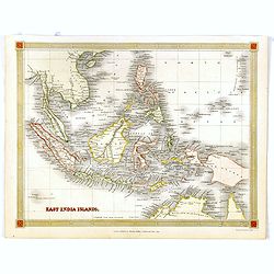
East India Islands.
An excellent map of Southeast Asia, from south Myanmar (Pegu) to a small part of northern Australia. Includes Singapore, Borneo, the Philippines, Indonesia, and a part of...
Place & Date: London, ca. 1835
Selling price: $55
Sold in 2017
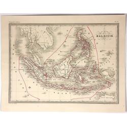
Carte de la Malaisie ou Grand archipel d'Asie.
Nice map of Indonesia, Philippines, Malacca with Singapore and tip of Northern Australia. Engraved by Thierry. Countries and regions in delicate out line color. Includes ...
Place & Date: Paris, 1835
Selling price: $100
Sold in 2018
East India Islands.
A detailed miniature map with a full-page table of place names and geographical coordinates. Shows the area from Yangon to New Guinea, including Hainan, Singapore, the Ph...
Place & Date: London, ca. 1835
Selling price: $50
Sold in 2018
Eastern Islands or Malay Archipelago
Detailed map of Indonesia by the SDUK. The SDUK was known to produce some of the most up-to-date and accurate maps in the early 19th century. The map includes many placen...
Place & Date: London 1836
Selling price: $25
Sold
Eastern Islands or Malay Archipelago.
This map provides good detail throughout the East Indies, Malaysia, Thailand, Laos, Cambodia, and the Philippines. Names Ache in northern Sumatra. There is little to no d...
Place & Date: London 1836
Selling price: $75
Sold in 2015
Die Ostindischen Inseln nach dem neuesten Berivchtigungen dargesteltt.
Map of Indonesia with Philippines. Engraved by Heinrich Leutemann (1814 - 1850). Included in Christian Gottfried Daniel Stein (1772-1839) "Neuer Atlas der ganzen Erd...
Place & Date: Leipzig, Hinrichs, 1837
Selling price: $190
Sold in 2016
Carte de la mer de Chine...
Highly decorative and scarce large-scale seachart of the South China Sea. Extending from China to Borneo with the Philippines and surroundings countries and islands! Ext...
Place & Date: Paris, 1838
Selling price: $550
Sold in 2011
Asiatic Archipelago.
Map of the Asiatic Archipelago with very good detail on the Philippines. In the lower-left corner inset of Singapore Island. This map by the nephew of Aaron Arrowsmith fi...
Place & Date: London, 1838
Selling price: $550
Sold in 2017
Le Insole della Sonda
Cassini’s splendid early map of Philippines, and Indonesia..Taken from the ""Nuovo Atlante Geografico Universale delineato sulle ultime osservazioni", pu...
Place & Date: Rome, Calcography, 1797-before 1839
East India Isles.
Somewhat later but very finely engraved and detailed map of south-east Asia, including modern day Myanmar (Burma), Thailand, Cambodia, Vietnam, Singapore, Malaysia, Indon...
Place & Date: 1840
Selling price: $200
Sold in 2018
East India Islands.
Uncommon map of Indonesia, including North coast of Australia and nice detail on Philippines, published by Thomas Kelly, 17 Paternoster Row, London.Engraved by Alexander ...
Place & Date: London, 1841
Selling price: $40
Sold in 2017
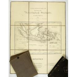
Algemeene Kaart van Nederlandsch Oostindie, met hoogstdezelfs toestemming opgedragen aan Zijne Majesteit den Koning der Nederlanden. . .
First and only edition. 8 Engraved maps and 1 general engraved map in contemp. outline colors, each sheet cut into 6 and laid on canvas. Preserved in cloth box. Each map ...
Place & Date: s-Gravenhage / Jakarta, 1842
Selling price: $2550
Sold in 2008
Kaart van Nederlands Oostindische bezittingen.
Detailed lithographed map of Indonesia published by ''Maatschappij tot nut van 't algemeen''. Lithographed and published by Daniel Veelwaard.
Place & Date: Amsterdam 1843
Selling price: $100
Sold
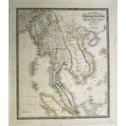
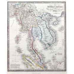
Map of the Burman Empire including also Siam, Cochin-China,Ton-King and Malaya from Calcutta to Hong Kong.
Superb map showing South East Asia, from Calcutta to Hong Kong. Includes many regions and place names such as the Burman Empire, Siam (Thailand), Cochin China and Tonking...
Place & Date: London, c1843
Selling price: $300
Sold in 2012
Carte de la Malaisie.
Fine lithographed map of South East Asia by A Vuillemin. Includes Malaysia, the Philippines, Indonesia, Singapore and Java. It is from the atlas "GEOGRAPHIE MODERNE&...
Place & Date: Paris , 1843
Selling price: $30
Sold in 2017
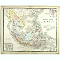
S.E. Peninsula and Malaysia.
Very detailed map of South-east Asia with Philippines, Malaysia, Formosa (Taiwan) by A.K. Johnston's.Inset maps of "Island and Strait of Singapore. Properly Singhapu...
Place & Date: London, Edward Stanford, ca. 1844
Selling price: $350
Sold in 2020
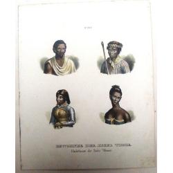
Bewohner der Insel Timor, Habitans de L'Isle Timor.
Four hand colored pictures on one print of inhabitants of the Island of Timor. From "NATIVE PEOPLE OF THE WORLD" by Heinrich Rudolf Schinz in Zurich, Switzerlan...
Place & Date: Zürich, 1845
Selling price: $12
Sold in 2017
Kaart van de vaarwaters en eilanden tusschen Sumatra en Borneo. . .
Very large and rare centered on the island of Bangka, showing the southeastern coast of Sumatra.With large title surmounted by 4 small inset maps showing details of the ...
Place & Date: Amsterdam, 1847
Selling price: $700
Sold
Oceanie, Description Historique Sur L'Ocean
A fine map of the southern Pacific Ocean, with decorative borders and views. Margin illustrations of excellent quality showing local peoples, explorers, products, landsca...
Place & Date: Paris, 1847
Selling price: $37
Sold in 2020
Malesia ossia Arcipelago Indiano, ed India-Transgangetica.
Attractive map of the Southeast Asia with inset map: Arcipelago di Andaman, Arcipelago di Nicobar. A wealth of information listing his cartographic sources and giving pol...
Place & Date: Naples, 1848-1854
Selling price: $250
Sold in 2017
East Indian Islands.
Superb map of Indonesia, filled with many place names. Shows the area from Birma and Thailand to Papua New Guinea, including the Philippines, Singapore, Malaysia, Borneo,...
Place & Date: London, ca. 1855
Selling price: $58
Sold in 2015
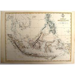
The Indian Archipelago.
A detailed map of the Indian Archipelago including The Philippines, Sumatra, Java and most of Papua & New Guinea. Has a small cartouche "The Dispatch Atlas"...
Place & Date: London, 1858
Selling price: $100
Sold in 2013
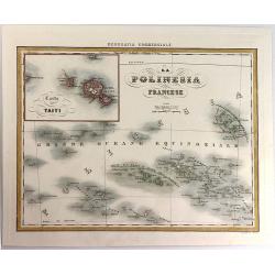
La Polinesia Francese.
A pleasant map featuring the Polynesian Islands, with an insert of Tahiti (Carta di Taiti). It is from the atlas "Geografia Commerciale", engraved by G. Bonatti...
Place & Date: Torino, 1858
Selling price: $21
Sold in 2016
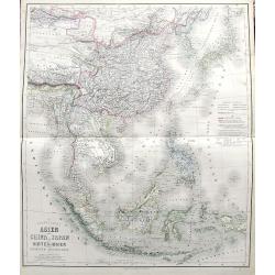
Das südöstliche Asien oder China, Japan, und Hinter-Indien mit dem Indischen Archipelagus.
Superb map from Mongolia until Timor. Includes Korea, Japan, China, the Philippines, Thailand, Singapore, Indonesia, etc. Richly detailed filled with place names. The col...
Place & Date: Weimar, 1858
Selling price: $130
Sold in 2017

Le Isole della sonda Borneo, Sumatra, Giava Celebes e Le Molucche.
Uncommon map of Southeast Asia including Singapore, much of Indonesia, Bali, Timor, Borneo, the island of Mindanao in the Philippines, and the northern coast of Australia...
Place & Date: Genova, Paolo Rivara fu Giacomo, 1858
Selling price: $50
Sold in 2021
![[ South East Asia with the North East coast of Australia ].](/uploads/cache/26130-250x250.jpg)
[ South East Asia with the North East coast of Australia ].
General map of the South East Asia with the North East coast of Australia.
Place & Date: France, c. 1860
Selling price: $95
Sold in 2013
Oostindië en China.
Uncommon map of India, South East Asia, Taiwan, Japan and China. Lithography by J.H. van Weijer, published in Atlas der geheele Aarde [?] in 24 kaarten. With colored key...
Place & Date: Groningen, ca. 1860
Selling price: $30
Sold in 2008
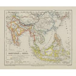
Map of Hindoostan, Farther India, China, and Tibet.
Fantastic 1860 map which includes today's countries of India, Maledives, Pakistan, Bangladesh, Nepal, Bhutan, Thailand, Vietnam, Cambodia, Laos, Myanmar, Malaysia, Singap...
Place & Date: Philadelphia, 1860
Selling price: $130
Sold in 2012
Kaart van de westerhelft der Residentie Timor.
Rare detailed map of the Indonesian islands Flores, Sumba, Sawu, Pulau Komodo, and several smaller ones. The map includes regions, rivers, towns. Relief is shown by h...
Place & Date: Haarlem, 1860
Selling price: $80
Sold in 2016
Die Ostindischen Inseln entw. u. gez. von F. v. Stülpnagel und Herm. Berghaus.
Superb map of Indonesia, filled with place names. Shows the area from Thailand to Papua New Guinea, including the Philippines, Singapore, Malaysia, Borneo, and the Indone...
Place & Date: Gotha, 1862
Selling price: $202
Sold in 2014
THE INDIAN ARCHIPELAGO (Indonesia & Borneo)
Original steel engraved map drawn & engraved by Edward Weller, published by Blackie & Son, in Edinburgh 1864.
Place & Date: Edinburgh, 1864
Selling price: $60
Sold in 2015
Map of the Burman Empire including also Siam, Cochin-China, Ton-King, and Malaya.
A fine map of the area, including today's Thailand, Vietnam, Sincapore (Singapore), and a part of Borneo. Notes of size and population of Birman Empire, Anam, Siam, Malay...
Place & Date: London, 1864
Selling price: $150
Sold in 2021
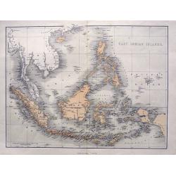
Indian Archipelago and Further India. Including Burmah, Siam, Anam &c.
The map covers the area from India - China - Formoza (Taiwan) in the North to New Guinea and the tip of Australia in the South.
Place & Date: Edinburgh, 1870
Selling price: $65
Sold in 2014