Browse Listings in Asia > South East Asia
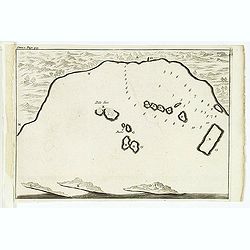
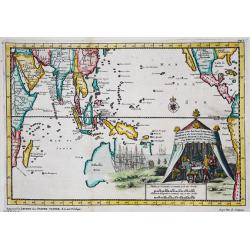
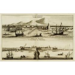
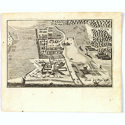
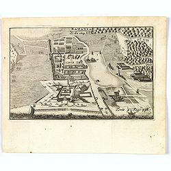
(Bird's eye view of the Bay of Bantam.)
Bird's eye view of the Bay of Bantam after Willem Lodewijcksz.From the French reissue of the account of early Dutch voyages first published in 1608 by Commelin. The Frenc...
Place & Date: Amsterdam, E. Roger, 1702
Selling price: $70
Sold in 2014
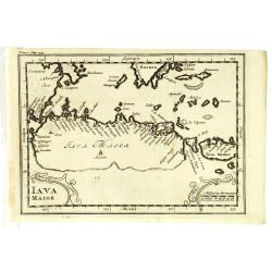
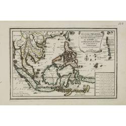
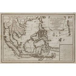
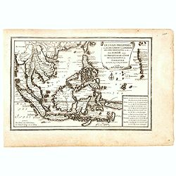
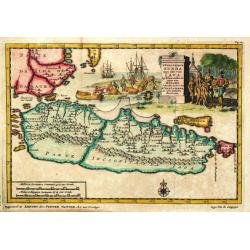
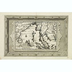
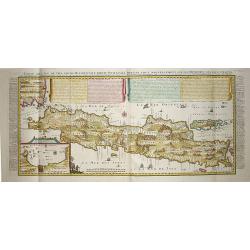
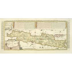
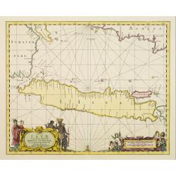
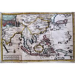
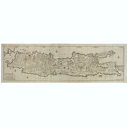
Iava Maior.
Nice early map of Java. From the French reissue of the account of early Dutch voyages first published in 1608 by Commelin. The French translation was carried out by René...
Place & Date: Amsterdam, E. Roger, 1702
Selling price: $195
Sold in 2013
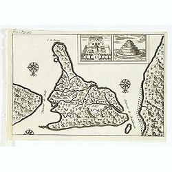
( Detroit de Baly / Detroit de Ballabuan. )
Nice early map of Bali. From the French reissue of the account of early Dutch voyages first published in 1608 by Commelin. The French translation was carried out by René...
Place & Date: Amsterdam, E. Roger, 1702
Selling price: $150
Sold in 2013
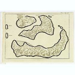
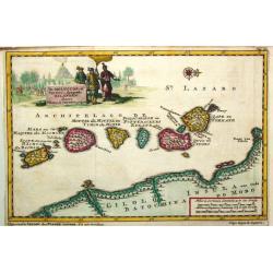
(Gunanappi / Wayer / Nera / Pulorin / Puloway .)
Uncommon map of islands in the Banda Sea. Several islands and villages are named, Wayer, Nera, Pulorin, Puloway, Lontoor, Ortattan and Combeer.From the French reissue of ...
Place & Date: Amsterdam, E. Roger, 1702
Selling price: $55
Sold in 2012
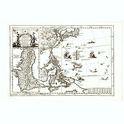
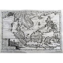
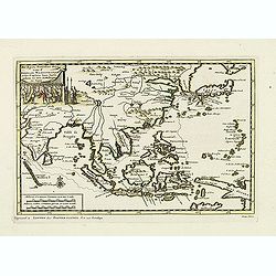
![[map of South East Asia ]](/uploads/cache/31872-250x250.jpg)
[map of South East Asia ]
The map is an expanded version of De Bry's "Mar di India", with the inclusion of an inset map of Buton (Botton I. 140x105mm.). The Straits of Buton, highlighted...
Place & Date: Amsterdam, E. Rogers, 1702
Selling price: $1000
Sold in 2012
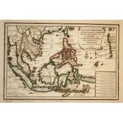
Nova Et Vera Exhibitio Gerographica Insularum Marianarum . . .
Attractive map of the Philippines, Japan, Korea and Indonesia with an inset of the island Guam, by the Jesuit Heinrich Scherer, printed in for Scherer's 'Atlas Novus'. Se...
Place & Date: Munich, c.1702
Selling price: $800
Sold in 2016
Nova Et Vera Exhibitio Gerographica Insularum Marianarum . . .
Attractive map of the Philippines, Japan, Korea and Indonesia with an inset of the island Guam, by the Jesuit Heinrich Scherer, printed in for Scherer's 'Atlas Novus'. Se...
Place & Date: Munich, c.1702
Selling price: $800
Sold in 2018
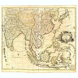
A New Map of the East Indies taken form Mr. de Fer's Map of Asia.
Striking scarce regional map of India and the East Indies, extending from Southeast Asia, the Philippines, China and Tibet in the East to India and the Maldives in the We...
Place & Date: London, 1703
Selling price: $211
Sold in 2015
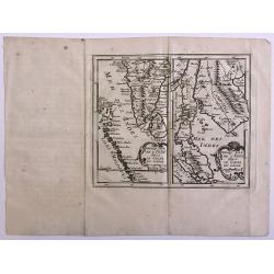
Presqu'Isle De L'Inde De Ca Le Golfe Du Gange/Presqu'Isle De L'Inde De La Le Golfe Du Gange.
Pair of maps, one of the Indian peninsula and Sri Lanka, and another of Southeast Asia, including Singapore.
Place & Date: Paris, c.1704
Selling price: $25
Sold in 2012
Les Isles Philippines
Striking map of the East Indies. From De Fer's Atlas Curieux. Nice wide margins and decorative cartouche.
Place & Date: Paris, 1705
Selling price: $250
Sold in 2009
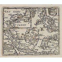
Les isles Philippines, Molucques../Les isles du Iapon.
A map of the Indonesian and Philippines islands with an insert showing the three main Japanese islands, by Nicolas De Fer, Royal French Geographer.
Place & Date: Paris, 1705
Selling price: $265
Sold in 2015
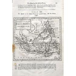
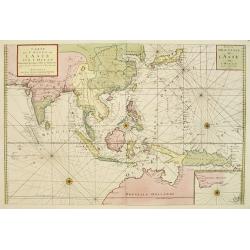
The Principal Islands of the East Indies.
A detailed copper engraved map of Indonesia and the Philippines, that Includes a small tip of New Holland (Australia) and names the Singapore Strait. With interesting tex...
Place & Date: London, ca 1705
Selling price: $35
Sold in 2019
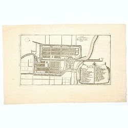
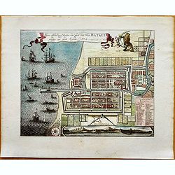
Plan de Batavia.
An excellent example of de Fer's town plan of Batavia (Jakarta) produced early in the 18th century, when the city and region was under the direct control and influence of...
Place & Date: Paris, 1705
Selling price: $60
Sold in 2021
Les Isles Philippines et celles Des Larrons oude Marianes, Les Isles Moluques et de la Sonde, avec la Presqu'isle de L'Inde de la le Gange ou Orientale?
A map of the Malaysia, Indonesian and Philippines islands, by Nicolas De Fer, Royal French Geographer. The island of Taiwan is labeled "I.Formosa ou Bel Isle".
Place & Date: Paris, 1706
Selling price: $900
Sold in 2015
Les Isles Philippines et celles Des Larrons oude Marianes, Les Isles Moluques et de la Sonde, avec la Presqu\'isle de L\'Inde de la le Gange ou Orientale.
A map of the Malaysia, Indonesian and Philippines islands, by Nicolas De Fer, Royal French Geographer. The island of Taiwan is labeled "I.Formosa ou Bel Isle".
Place & Date: Paris, 1706
Selling price: $300
Sold in 2010
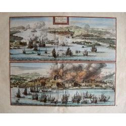
La Ville de Palimbang dans L'Ile de Sumatra.
A very decorative, impressive old-colored engraving of Palembang in Sumatra. Two views on one sheet. In the upper part the overall view with a sea battle in the foregroun...
Place & Date: Leiden, 1706
Selling price: $130
Sold in 2014
Les Isles Philippines et celles Des Larrons ou de Marianes, Les Isles Moluques et de la Sonde, avec la Presqu'isle de L'Inde de la le Gange ou Orientale...
A scarce map of the Malaysia, Indonesian and Philippines islands, by Nicolas De Fer, Royal French Geographer. The island of Taiwan is labeled "I.Formosa ou Bel Isle&...
Place & Date: Paris, 1706
Selling price: $600
Sold in 2016
De Moluccos, of Speceri-dragende Eilanden Tussen Cilolo en Celebes gelegen.
Pieter van der Aa was a prolific publisher. He published a.o. ' Naaukeurige versameling der gedenkwaardigste zee- en land-reysen', a series of accounts of voyages (1706-0...
Place & Date: Leiden, 1707
Selling price: $300
Sold
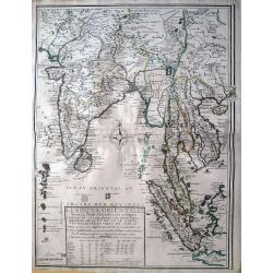
'T Koninkryk Sunda met dat van Java
Pieter van der Aa was a prolific publisher. He published a.o. ' Naaukeurige versameling der gedenkwaardigste zee- en land-reysen', a series of accounts of voyages (1706-0...
Place & Date: Leiden, 1707
Selling price: $350
Sold
Het eiland Sumatra hoe ten aansien van Malacca . . .
Map of Sumatra, lower part of Malacca with Singapore (Singapura) and western part of Borneo. In lower left a fine title cartouche showing locals.Although not renowned for...
Place & Date: Leiden, 1707
Selling price: $150
Sold in 2009
Het eiland Sumatra hoe ten aansien van Malacca . . .
Map of Sumatra, lower part of Malacca with Singapore (Singapura) and western part of Borneo. In lower left a fine title cartouche showing locals.Although not renowned for...
Place & Date: Leiden, 1707
Selling price: $220
Sold in 2012
Indien onder den Heer Lopo Vaz Sampayo, als Gouverneur Generaal tot aan Nieuw-Spanje in America en kusten van Peru en Chili bevaaren.
Pieter van der Aa was a prolific publisher. He published a.o. ' Naaukeurige versameling der gedenkwaardigste zee- en land-reysen', a series of accounts of voyages (1706-0...
Place & Date: Leiden, 1707
Selling price: $425
Sold in 2015
D'Indize Kusten van Bengale, Pegu, Malacca en Siam tot in China, met d'Eylanden Sumatra, Iava, Borneo, Moluccos en andere.
A map of Indonesia extending from the Gulf of Bengal to Taiwan (Formosa) and south to Timor. Including southern China, the Philippines, Sumatra, Borneo, Vietnam and Cambo...
Place & Date: Leiden, 1707
Selling price: $305
Sold in 2017
D'Indiaanze Landschappen, Zeen en Eylanden, van Couchin Af, tot in de Moluccos, En na by Gelegen Eylanden, Door Antionio Galvaon Besyevend.
Map of Southeast Asia with India, Malacca, Philippines, Indonesia, Formosa, etc. Lower left a fine title cartouche showing a naval battle and a siege of a town.The map wa...
Place & Date: Leiden? 1707
Selling price: $250
Sold in 2016
Prequ Isle de L'Inde deca Le Golfe du Gange and Prequ Isle de l
A very rare double map of India, Sri Lanka and the Maldives islands, together with a separate map of Cambodia, Thailand, Malaysia and North Sumatra.
Place & Date: 1708
Selling price: $50
Sold in 2016
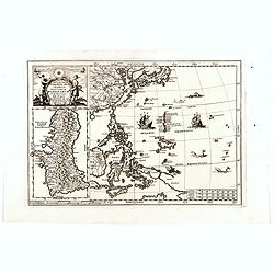
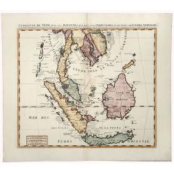
![Le Royaume de Siam avec Les Royaumes Qui Luy sont Tributaries & c. / La Royaume de Siam avec les royaumes qui luy sont Tributaires, et les Isles de Sumatra, Andemaon, etc. . . [two sheet map]](/uploads/cache/27847-250x250.jpg)
Le Royaume de Siam avec Les Royaumes Qui Luy sont Tributaries & c. / La Royaume de Siam avec les royaumes qui luy sont Tributaires, et les Isles de Sumatra, Andemaon, etc. . . [two sheet map]
Influential map of Southeast Asia and the East Indies including modern day Thailand, southern Vietnam, Cambodia, Malaysia, Singapore, Borneo, Sumatra and Java. Ottens inc...
Place & Date: Amsterdam, 1710
Selling price: $2500
Sold in 2009
![Le Royaume de Siam avec Les Royaumes Qui Luy sont Tributaries & c. / La Royaume de Siam avec les royaumes qui luy sont Tributaires, et les Isles de Sumatra, Andemaon, etc. . . [two sheet map]](/uploads/cache/33564-250x250.jpg)
Le Royaume de Siam avec Les Royaumes Qui Luy sont Tributaries & c. / La Royaume de Siam avec les royaumes qui luy sont Tributaires, et les Isles de Sumatra, Andemaon, etc. . . [two sheet map]
Influential map of Southeast Asia and the East Indies including modern day Thailand, southern Vietnam, Cambodia, Malaysia, Singapore, Borneo, Sumatra and Java. Ottens inc...
Place & Date: Amsterdam, 1710
Selling price: $1550
Sold in 2013
Scheeps-Togt van Malacca na de Golf van Bengale en de kusten van Siam tot in China.
Rare map of the Indian Ocean and Malacca with Singapore (Cingapura) Although not renowned for the originality of his work, Pieter van der Aa is highly thought of for the ...
Place & Date: Leiden, 1713
Selling price: $400
Sold in 2011
De Agste Oostinische Reys voor d' Engelze Maatschappie onder Kapitein Joan Saris, gedaan na Java, de Moluccas en Japan.
Map of the route of the English captain Joan Saris to Japan.Although not renowned for the originality of his work, Pieter van der Aa is highly thought of for the design a...
Place & Date: Leiden, 1714
Selling price: $220
Sold in 2011
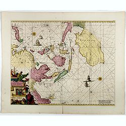
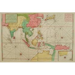
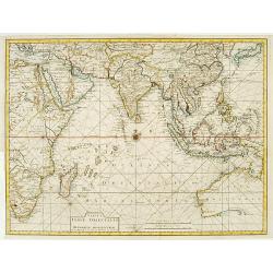
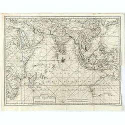
Orientaliora Indiarum Orientalium..C.Comorin ad Iapan.
The uncommon Louis Renard edition. - A superb late 17th century Dutch sea-chart of Australia and the East Indies, closely modelled on Pieter Goos' chart of 1666. The char...
Place & Date: Amsterdam, 1680-1715
Selling price: $3300
Sold in 2016
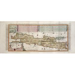
CARTE DE L'ILE DE JAVA: PARTIE OCCIDENTALE, PARTIE ORIENTALE DRESSEE...
A decorative large format map of Java, with an inset of the bay of Batavia in the lower left corner.Two title banners include a short sketch of the history of the Dutch o...
Place & Date: Amsterdam, 1718
Selling price: $950
Sold in 2017
La ville de Batavie / Cheaçteau de Batavia.
From La Galerie agréable du monde.
Place & Date: Leiden c.1719
Selling price: $150
Sold
Carte de l'' Isle de Java..
This important large-scale chart of the island of Java is one of the finest 18th century maps of the island. The map is filled with details of rice fields, mountains, for...
Place & Date: Amsterdam, 1719
Selling price: $1400
Sold in 2008
Carte de l'Ile de Java: partie Occidentale, partie Orientale, Dressée tout nouvellement sur les Mémoirs les plus exacts, Avec une Table des principales villes de cette Ile. . .
An inset plan of Batavia and clearly indicated rice fields, mountains, forests, towns in profile and even elephants suggest the wealth of detail found on this map. Modell...
Place & Date: Amsterdam, François L'Honoré & Châtelain, 1719
Selling price: $1500
Sold in 2020
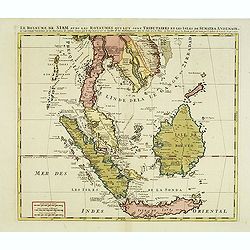
LE ROYAUME DE SIAM avec les ROYAUMES QUI LUY sont TRIBUTAIRES et les Isles de SUMATRA ANDEMAON.
A beautiful, old colored map of South East Asia shows the Kingdom of Siam (Thailand), the Malaysian Peninsula and the islands of Borneo, Sumatra and Java. This was the do...
Place & Date: Amsterdam, 1719
Selling price: $375
Sold in 2019
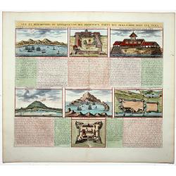
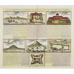
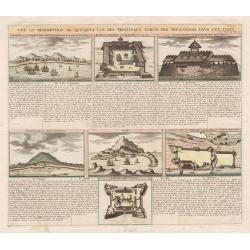
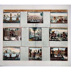
Vue et description de quelques-uns des principaux forts des Hollandois dans les Indes. (Dutch Forts).
A clean plate with seven detailed views illustrating the most important Dutch trading outposts and fortified colonial possessions in the East Indies. This plate includes ...
Place & Date: Amsterdam, 1719
Selling price: $130
Sold in 2019
Insulae Iavae Borneo Sumatrae..
No text on verso. A finely engraved map in the classic Dutch baroque style of Java and parts of Bali, Sumatra, and Borneo.
Place & Date: Amsterdam 1720
Selling price: $686
Sold
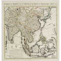
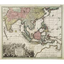
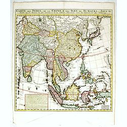
Carte des Indes, de la Chine & des Isles de Sumatra, Java &c..
This fine and quite detailed general map extends from northern Japan to Timor and from India to New Guinea.Here, the Terre de Yeco in northern Japan is still joined to th...
Place & Date: Amsterdam 1720
Selling price: $200
Sold
Carte des costes de l'Asie sur l'Ocean..
Pristine nautical chart with an inset of southern coast of southern Australia and Tasmania in the wake of Tasman and other 17th century Dutch explorations of these region...
Place & Date: Amsterdam 1720
Selling price: $3700
Sold
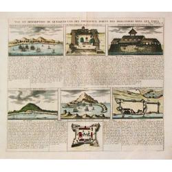
Vue et Description de quelques-uns des principaux forts des Hollandois..
This impressive engraving is a wonderful example of Chatelain's elegant plates.Ornamented with numerous vignettes representing some of the Dutch settlements in the East I...
Place & Date: Amsterdam, ca. 1720
Selling price: $160
Sold in 2008
Vue et description de quelques-uns des principaux forts des Hollandois dans les Indes.
Henri Abraham Chatelain was a Amsterdam-based geographer and publisher. His main product is the 'Atlas Historique et Méthodique', in seven volumes, published between 171...
Place & Date: Amsterdam, 1710-1720
Selling price: $180
Sold in 2010
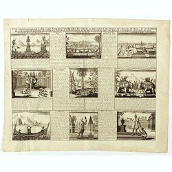
Vue & description de la ville de Siam, des pagodes, des Talapoins ou religieux de ce pais. . .
This impressive engraving is a wonderful example of Chatelain?s elegant plates.Exhaustive information about each scene is given in lengthy tables.Zacharie Chatelain (d.17...
Place & Date: Amsterdam, ca. 1720
Selling price: $250
Sold in 2008
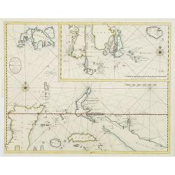
![Carte d'une partie de la Chine, les Isles Philippines, de la Sonde, Moluques, ... Carte des Indes, de la Chine & des Iles de Sumatra, Java / Indes Orientalis. . . [two maps]](/uploads/cache/02448-250x250.jpg)
Carte d'une partie de la Chine, les Isles Philippines, de la Sonde, Moluques, ... Carte des Indes, de la Chine & des Iles de Sumatra, Java / Indes Orientalis. . . [two maps]
A fine detailed double-sheet map of the South East Asia. The map draws information from the late 17th century French Jesuit accounts of Thailand and Siam and has good det...
Place & Date: Amsterdam, 1720
Selling price: $1500
Sold in 2014
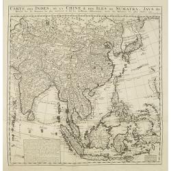
Carte des Indes, de la Chine & des Isles de Sumatra, Java &c..
This fine and quite detailed general map extends from northern Japan to Timor and from India to New Guinea.Here, the Terre de Yeco in northern Japan is still joined to th...
Place & Date: Amsterdam, 1720
Selling price: $500
Sold in 2010
De Agste Oostindize Reys voor d'Engelse Maatschappie. . .
Fine map of the Far East including China, Japan, and the East Indies highlighting the voyage of John Saris, captain of “The Clove”. Saris commanded the first English ...
Place & Date: Leiden, 1720
Selling price: $90
Sold in 2010
India Orientalis cum adjacentibus. . .
The finely engraved detail shows the whole of the region from India to the Dutch discoveries in the Gulf of Carpentaria in northern Australia. The map is embellished by a...
Place & Date: Augsburg, 1720
Selling price: $850
Sold in 2010
Carte des Costes de L'Asie sur L'Ocean Contenant les Bancs Isles et Costes &c . . . Partie Orientale de L'Asie sur L'Ocean .
Pristine nautical with an inset of southern coast of southern Australia and Tasmania in the wake of Tasman and other 17th century Dutch explorations of these regions: di...
Place & Date: Amsterdam, 1720
Selling price: $4000
Sold in 2015
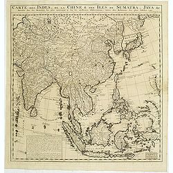
Carte des Indes, de la Chine & des Isles de Sumatra, Java &c..
This fine and quite detailed general map extends from northern Japan to Timor and from India to New Guinea.From the important Atlas Historique et Méthodique.Here, the Te...
Place & Date: Amsterdam, 1720
Selling price: $500
Sold in 2011
Le Royaume de Siam avec Les Royaumes Qui Luy sont Tributaries & c.
Influential map of Southeast Asia, including modern day Thailand, southern Vietnam, Cambodia, Malaysia, Singapore, Borneo, Sumatra and Java. Chatelain incorporated inform...
Place & Date: Amsterdam, c.1720
Selling price: $1100
Sold in 2014
Vue et Description de quelques-uns des principaux forts des Hollandois dans les Indes.
This impressive engraving is a wonderful example of Chatelain’s elegant plates.Ornamented with numerous vignettes representing some of the Dutch settlements in the East...
Place & Date: Amsterdam, c.1720
Selling price: $80
Sold in 2013
Carte des Indes, de la Chine & des Isles de Sumatra, Java &c..
This fine and quite detailed general map extends from northern Japan to Timor and from India to New Guinea.Here, the Terre de Yeco in northern Japan is still joined to th...
Place & Date: Amsterdam, 1720
Selling price: $500
Sold in 2017

Carte des Indes, de la Chine & des Isles de Sumatra, Java &c..
This fine and quite detailed general map extends from northern Japan to Timor and from India to New Guinea.Here, the Terre de Yeco in northern Japan is still joined to th...
Place & Date: Amsterdam, 1720
Selling price: $450
Sold in 2018
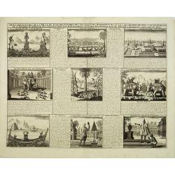
Vue & description de la ville de Siam, des pagodes, des Talapoins ou religieux de ce pais. . .
Page with a profile view on the capital Ayutthaya, the throne of the King, the King who rides an elephant, ships on a lake, the typical plants such as ginseng, the monks ...
Place & Date: Amsterdam, ca. 1720
Selling price: $150
Sold in 2020
Vue & description de la ville de Siam, des Pagodes, des Talapoins oureligeux ce ce pais, des balons du roi & de ses elephans, de la maniere de dompter ces ..
Page with a profile view on the capital Ayutthaya, the throne of the King, the King who rides an elephant, ships on a lake, the typical plants such as ginseng, the monks ...
Place & Date: Amsterdam, ca. 1720
Selling price: $120
Sold in 2019
Les Indes Orientales sous le Nom de queles est compris L'Empire du Grand Mogol, Les Deux Presqu'Isles Deca et de la Le Gange, Les Maldives, et L'Isle de Ceylan...
Rare map of Southeast Asia, showing India, Tibet, parts of China with Canton, Malaysia, Singapore (Sincapur), Thailand, Sumatra, the Maledives, parts of Borneo and Java. ...
Place & Date: Paris, 1721
Selling price: $850
Sold in 2015
A New Map of India & China From the latest Observations. . .
Fine map of Indonesia, India, China, Philippines, Japan, Korea and Taiwan, with decorative title cartouche. With dedication to the directors of the English East India Com...
Place & Date: London, 1721
Selling price: $750
Sold in 2016
Waere Affbeeldinge Wegens het Casteel ende Stadt BATAVIA Gelegen opt Groot Eylant Java.
Excellent impression of Batavia's finely engraved and detailed plan, present-day Jakarta, the Dutch center of trading activities in the East Indies. Copied after Clement ...
Place & Date: Amsterdam, 1721
Selling price: $1750
Sold in 2016

Waere Affbeeldinge Wegens het Casteel ende Stadt BATAVIA Gelegen opt Groot Eylant Java.
A good impression of this finely engraved and detailed plan of Batavia, present-day Jakarta, the Dutch center of trading activities in the East Indies. Copied after Cleme...
Place & Date: Amsterdam, 1721
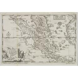
Nieuwe Kaart van het Eyland Sumatra..
Fine chart depicting the Island of Sumatra and the southern coasts of Malaysia from Quedo to Johore. North is orientated to the left of the page. Singapore is probably id...
Place & Date: Amsterdam 1724
Selling price: $361
Sold
Kaart van het eyland Borneo.
Fine chart depicting the Island of Borneo. North is orientated to the left of the page.Little interior detail is given but the coastlines, settlements and principal coast...
Place & Date: Amsterdam 1724
Selling price: $400
Sold
Nieuwe Kaart van Choromandel ende Malabar..
"Fine chart depicting the southern part of India and the northern tip of Ceylon. Much detail is given along the coastlines, settlements and principal coastal feature...
Place & Date: Amsterdam 1724
Selling price: $150
Sold
De Landvoogdy der Moluccos..
"Fine chart depicting the Moluccas islands. Little interior detail is given but the coastlines, settlements and principal coastal features are identified. To the low...
Place & Date: Amsterdam 1724
Selling price: $1000
Sold
Tabula Indiae Orientalis et regnorum adjacentium.
The map originally appeared in Valentijn's book Oud en Nieuw Oost-Indien (Dordrecht/Amsterdam 1724/26). With in the right bottom corner the imprint J.van Braam en G. onde...
Place & Date: Amsterdam 1724
Selling price: $800
Sold
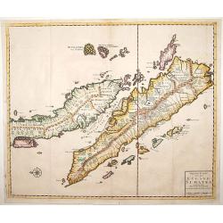
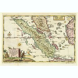
Nieuwe Kaart van het Eyland Sumatra..
Fine chart depicting the Island of Sumatra and the southern coasts of Malaysia from Quedo to Johore. North is orientated to the left of the page. Singapore is probably id...
Place & Date: Amsterdam 1724
Selling price: $1050
Sold
De Landvoogdy der Moluccos..
Fine chart depicting the Moluccas islands. Little interior detail is given but the coastlines, settlements and principal coastal features are identified. To the lower rig...
Place & Date: Amsterdam, 1724
Selling price: $400
Sold in 2008
Tabula Indiae Orientalis et regnorum adjacentium.
Highly detailed map of Australia, Southeast Asia and the Indian Ocean depicting the working area of the V.O.C. The map originally appeared in Valentijn's book Oud en Nieu...
Place & Date: Amsterdam, 1724
Selling price: $2250
Sold in 2015
Nieuwe en zeer naaukeurige kaart van t eyland Java Major of Groot Java : verdeeld in seven byzondere bestekken. . .
This large-scale map of Java is richly engraved with details of agricultural fields, roads, temples, and topography. The coastline is filled with soundings, anchorages, s...
Place & Date: Amsterdam, 1724
Selling price: $1750
Sold in 2020
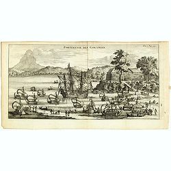
Forteresse des Goramois.
Showing a view of the fortress of Goram. From the French reissue of the account of early Dutch voyages first published in 1608 by Commelin. The French translation was car...
Place & Date: Amsterdam, F. Bernard, 1725
Selling price: $50
Sold in 2016
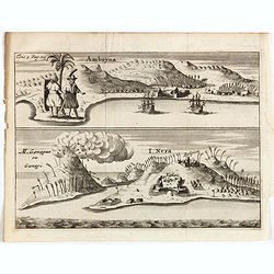
Amboyna. / I.Neri.
Fine engraving of the Dutch and English enclaves at Amboyna (top) and Banda-Neira (bottom). From the French reissue of the account of early Dutch voyages first published ...
Place & Date: Amsterdam, F. Bernard, 1725
Selling price: $65
Sold in 2016
MACASAR, Capitale de Roiaume de meme nom.
A copperplate engraving that originates from the very scarce: 'La galerie agreable du monde. Tome premier des Indes Orientales.', published by P. van der Aa, Leyden, ca 1...
Place & Date: Leiden, 1725
Selling price: $150
Sold in 2019
Batavia, L'an 1629.
Scarce town-view of Batavia (Jakarta) in 1629.From the French reissue of the account of early Dutch voyages first published in 1608 by Commelin. The French translation wa...
Place & Date: Amsterdam, 1725
Selling price: $70
Sold in 2020
![Les Iles de BANDA [Indonesia].](/uploads/cache/83246-250x250.jpg)
Les Iles de BANDA [Indonesia].
This plate originates from the very scarce: 'La galerie agreable du monde (...). Tome premier des Indes Orientales.', published by P. van der Aa, Leyden, ca. 1725. This f...
Place & Date: Leiden, 1725
Selling price: $41
Sold in 2019
Batavia, L'an 1629.
Scarce town-view of Batavia (Jakarta) in 1629.From the French reissue of the account of early Dutch voyages first published in 1608 by Commelin. The French translation wa...
- $150 / ≈ €140
Place & Date: Amsterdam, 1725
Het eyland Neira, en het Casteel Nassau mitgaders Belgica.
"Decorative panoramic view of the island of Neira with European vessels in the foreground. The island belongs to the Banda islands.Françcois Valentijn (1666-1727), ...
Place & Date: Amsterdam 1726
Selling price: $220
Sold
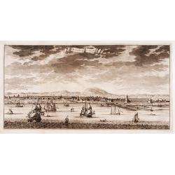
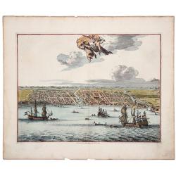
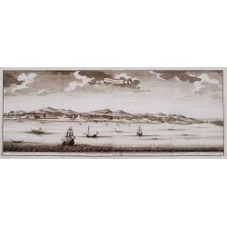
Batavia in 't verschiet.
Decorative panoramic view of Batavia, present-day Jakarta with European vessels in the foreground.Françcois Valentijn (1666-1727), a missionary, worked at Amboina from 1...
Place & Date: Amsterdam 1726
Selling price: $250
Sold
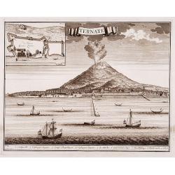
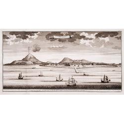
Ternate.
"Decorative panoramic view of Ternate with European vessels in the foreground. In upper left corner inset plan of the Fortress Oranje.Françcois Valentijn ...
Place & Date: Amsterdam 1726
Selling price: $100
Sold
Amboina.
"Decorative panoramic view of the island of Amboina with European vessels in the foreground.Françcois Valentijn (1666-1727), a missionary, worked at Amboi...
Place & Date: Amsterdam 1726
Selling price: $300
Sold
![Boero and Amblauw. [no title]](/uploads/cache/15927-250x250.jpg)
Boero and Amblauw. [no title]
"Decorative map of the islands of Boero and Amblauw.Françcois Valentijn (1666-1727), a missionary, worked at Amboina from 1684 to 1694 and 1705 to 1713 an...
Place & Date: Amsterdam 1726
Selling price: $110
Sold
De landvoogdy van Amboina met de elf onderhoorige Eylanden.
"Decorative map of the eastern tip of the islands of Amboina.Françcois Valentijn (1666-1727), a missionary, worked at Amboina from 1684 to 1694 and 1705 t...
Place & Date: Amsterdam 1726
Selling price: $100
Sold
![Western part of the island Amboina with Boero. [no title]](/uploads/cache/15930-250x250.jpg)
Western part of the island Amboina with Boero. [no title]
"Decorative map of the western tip of the islands of Amboina.Françcois Valentijn (1666-1727), a missionary, worked at Amboina from 1684 to 1694 and 1705 t...
Place & Date: Amsterdam 1726
Selling price: $175
Sold