Browse Listings in Asia > South East Asia
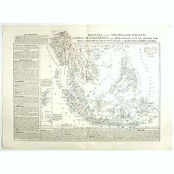
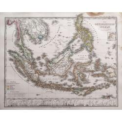
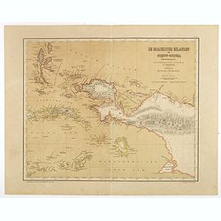
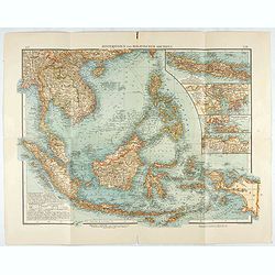
Malesia ossia Arcipelago Indiano, ed India-Transgangetica.
Attractive map of the Southeast Asia with inset map: Arcipelago di Andaman, Arcipelago di Nicobar. A wealth of information listing his cartographic sources and giving pol...
Place & Date: Naples, 1848-1854
Selling price: $250
Sold in 2017
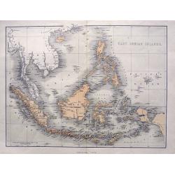
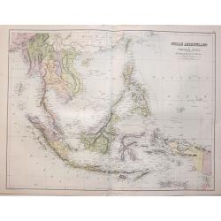
East Indian Islands.
Superb map of Indonesia, filled with many place names. Shows the area from Birma and Thailand to Papua New Guinea, including the Philippines, Singapore, Malaysia, Borneo,...
Place & Date: London, ca. 1855
Selling price: $58
Sold in 2015
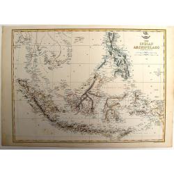
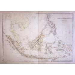
The Indian Archipelago.
A detailed map of the Indian Archipelago including The Philippines, Sumatra, Java and most of Papua & New Guinea. Has a small cartouche "The Dispatch Atlas"...
Place & Date: London, 1858
Selling price: $100
Sold in 2013
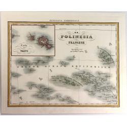
La Polinesia Francese.
A pleasant map featuring the Polynesian Islands, with an insert of Tahiti (Carta di Taiti). It is from the atlas "Geografia Commerciale", engraved by G. Bonatti...
Place & Date: Torino, 1858
Selling price: $21
Sold in 2016
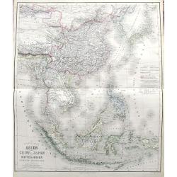
Das südöstliche Asien oder China, Japan, und Hinter-Indien mit dem Indischen Archipelagus.
Superb map from Mongolia until Timor. Includes Korea, Japan, China, the Philippines, Thailand, Singapore, Indonesia, etc. Richly detailed filled with place names. The col...
Place & Date: Weimar, 1858
Selling price: $130
Sold in 2017

Le Isole della sonda Borneo, Sumatra, Giava Celebes e Le Molucche.
Uncommon map of Southeast Asia including Singapore, much of Indonesia, Bali, Timor, Borneo, the island of Mindanao in the Philippines, and the northern coast of Australia...
Place & Date: Genova, Paolo Rivara fu Giacomo, 1858
Selling price: $50
Sold in 2021
![[ South East Asia with the North East coast of Australia ].](/uploads/cache/26130-250x250.jpg)
[ South East Asia with the North East coast of Australia ].
General map of the South East Asia with the North East coast of Australia.
Place & Date: France, c. 1860
Selling price: $95
Sold in 2013
Oostindië en China.
Uncommon map of India, South East Asia, Taiwan, Japan and China. Lithography by J.H. van Weijer, published in Atlas der geheele Aarde [?] in 24 kaarten. With colored key...
Place & Date: Groningen, ca. 1860
Selling price: $30
Sold in 2008
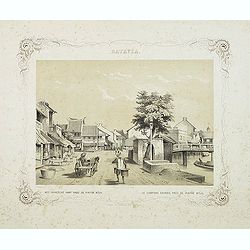
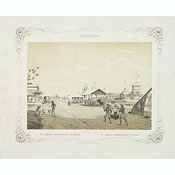
BATAVIA. Het chinesche kamp nabij de pintoe kitjil. Le campong chinois, près de Pintoe Kitjil.
Rare lithographed view of the Chinese camp nearby Pintoe Kitjil in Batavia (Jakarta). Beautiful lithography drawn by Charles Theodore Deeleman (1823 - 1884), lithographed...
Place & Date: Batavia, 1859-1860
Selling price: $200
Sold in 2011
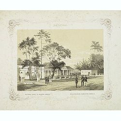
BATAVIA. Militaire school te Meester-Cornelis. Ecole militaire à Meester-Cornelis.
Rare lithographed view of the military school at Meester Cornelis in Batavia (Jakarta). Beautiful lithography drawn by Charles Theodore Deeleman (1823 - 1884), lithograph...
Place & Date: Batavia, 1859-1860
Selling price: $200
Sold in 2011
BATAVIA. Het jaagpad, landingsplaats te Batavia. Le jagpad, embarcadere à Batavia.
Rare lithographed view of the harbour of Batavia (Jakarta). Beautiful lithography drawn by Charles Theodore Deeleman (1823 - 1884), lithographed by G.J. Bos and printed b...
Place & Date: Batavia, 1859-1860
Selling price: $200
Sold in 2011
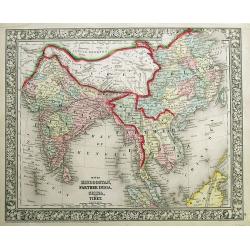
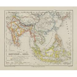
Map of Hindoostan, Farther India, China, and Tibet.
Fantastic 1860 map which includes today's countries of India, Maledives, Pakistan, Bangladesh, Nepal, Bhutan, Thailand, Vietnam, Cambodia, Laos, Myanmar, Malaysia, Singap...
Place & Date: Philadelphia, 1860
Selling price: $130
Sold in 2012
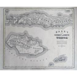
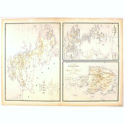
Kaart van de westerhelft der Residentie Timor.
Rare detailed map of the Indonesian islands Flores, Sumba, Sawu, Pulau Komodo, and several smaller ones. The map includes regions, rivers, towns. Relief is shown by h...
Place & Date: Haarlem, 1860
Selling price: $80
Sold in 2016
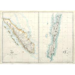
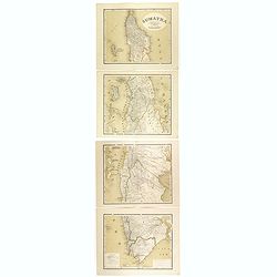
Sumatra; Java;
Two maps on one sheet. Both maps are highly detailed, filled with place names. The Sumatra map shows also Malaysia and Singapore. "The Weekly Dispatch" newspa...
Place & Date: London, ca. 1860
Selling price: $20
Sold in 2018
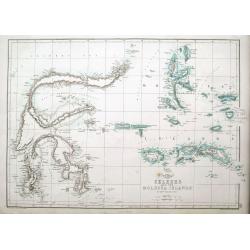
Celebes and the Molucca Islands.
A highly detailed map of the islands, also known as the Spice Islands, Celebes and Maluku Islands or the Moluccas, with many even small islands depicted. It depicts bays,...
Place & Date: London, ca 1860
Selling price: $20
Sold in 2018
Die Ostindischen Inseln entw. u. gez. von F. v. Stülpnagel und Herm. Berghaus.
Superb map of Indonesia, filled with place names. Shows the area from Thailand to Papua New Guinea, including the Philippines, Singapore, Malaysia, Borneo, and the Indone...
Place & Date: Gotha, 1862
Selling price: $202
Sold in 2014
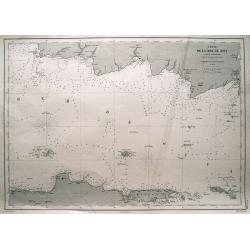
Carte de la mer de Java (partie orientale).
Large-scale sea-chart of the Java Sea. Shows parts of Java with Semarang, Surabaya; Madura island, Pulau Kangean, Bawean, Pulau Karimun Jawa, and southern part of Bornea ...
Place & Date: Paris, 1864
Selling price: $65
Sold in 2014
THE INDIAN ARCHIPELAGO (Indonesia & Borneo)
Original steel engraved map drawn & engraved by Edward Weller, published by Blackie & Son, in Edinburgh 1864.
Place & Date: Edinburgh, 1864
Selling price: $60
Sold in 2015
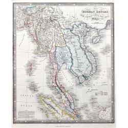
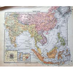
Map of the Burman Empire including also Siam, Cochin-China, Ton-King, and Malaya.
A fine map of the area, including today's Thailand, Vietnam, Sincapore (Singapore), and a part of Borneo. Notes of size and population of Birman Empire, Anam, Siam, Malay...
Place & Date: London, 1864
Selling price: $150
Sold in 2021
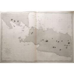
Ile de Java 1ère Feuille Partie Occidentale. . .
Large size sea-chart of the Sunda Strait. Shows parts of Sumatra and Java (extending east until Cirebon). With numerous small islands shown, depth soundings and anchoring...
Place & Date: Paris, 1869
Selling price: $145
Sold in 2014
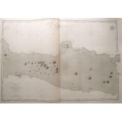
Ile de Java 2ème Feuille Partie Centrale. . .
Large size sea-chart of central Java. Extends from Indramayu until Madura. Includes Karimunjawa and Bawean in great detail. With depth soundings and anchoring places. Onl...
Place & Date: Paris, 1869
Selling price: $85
Sold in 2014
Indian Archipelago and Further India. Including Burmah, Siam, Anam &c.
The map covers the area from India - China - Formoza (Taiwan) in the North to New Guinea and the tip of Australia in the South.
Place & Date: Edinburgh, 1870
Selling price: $65
Sold in 2014
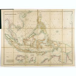
Asiatic Archipelago.
Map of the South East Asia with very good detail on Philippines. In lower left corner inset of Singapore Island. An extensive note on Singapore 'Singapore was granted to ...
Place & Date: London, 1876
Selling price: $400
Sold in 2019
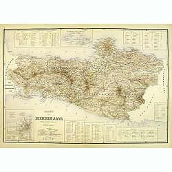
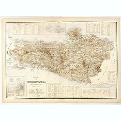
Kaart van midden Java. (tweede militaire afdeling)
Large map of central Java.
Place & Date: The Hague, c. 1880
Selling price: $250
Sold in 2012
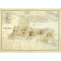
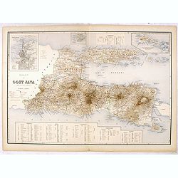
Kaart van oost Java. (derde militaire afdeling)
Large map of east Java.
Place & Date: The Hague, c. 1880
Selling price: $250
Sold in 2012
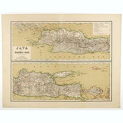
Java met Madoera en Bali. Schaal van 1:1750000.
A very detailed map of Java is divided in two parts, taken from "Atlas van Nederlandsch Oost- en West-Indie," prepared by a doctor I. Dornseiffen, and published...
Place & Date: Amsterdam, Seyffardt, 1884
Selling price: $35
Sold in 2017
Java op een schaal van 1:950 000
Very detailed map of Java in 4 sheets, with an inset map of 'Batavia met de haven werken' (Jakarta). Taken from "Atlas van Nederlandsch Oost- en West-Indie", pr...
Place & Date: Amsterdam, Seyffardt, 1884
Selling price: $50
Sold in 2017
Sumatra, Bangka, Blitong, Riouw, enz. (with Singapore)
Very detailed map of Sumatra, with Singapore to the East, taken from "Atlas van Nederlandsch Oost- en West-Indie", prepared by doctor I. Dornseiffen, and publis...
Place & Date: Amsterdam, Seyffardt, 1884
Selling price: $175
Sold in 2017
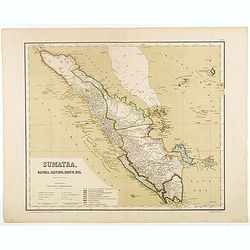
Sumatra op een schaal van 1: 1450000
Very detailed map of Sumatra on 4 sheets, taken from "Atlas van Nederlandsch Oost- en West-Indie", prepared by doctor I. Dornseiffen, and published by published...
Place & Date: Amsterdam, Seyffardt, 1884
Selling price: $85
Sold in 2017
Bangka en Blitong op een schaal van 1:750000.
Very detailed two sheet map of Bangka en Blitong, taken from "Atlas van Nederlandsch Oost- en West-Indie", prepared by doctor I. Dornseiffen, and published by p...
Place & Date: Amsterdam, Seyffardt, 1884
Selling price: $30
Sold in 2018
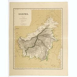
Borneo op een schaal van 1:420000.
Very detailed two sheet map of Borneo with some good detail to Brunei as well, taken from "Atlas van Nederlandsch Oost- en West-Indie", prepared by doctor I. Do...
Place & Date: Amsterdam, Seyffardt, 1884
Selling price: $130
Sold in 2017
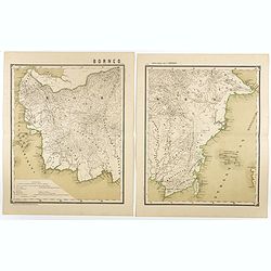
Borneo op een schaal van 1:1800000.
Very detailed two sheet map of Southern part of Borneo in two sheets, taken from "Atlas van Nederlandsch Oost- en West-Indie", prepared by doctor I. Dornseiffen...
Place & Date: Amsterdam, Seyffardt, 1884
Selling price: $20
Sold in 2017
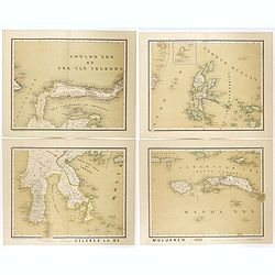
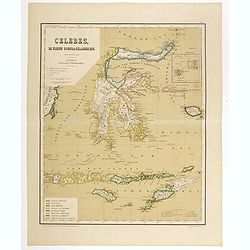
Celebes en de Molukken in vier bladen.
Very detailed four-sheet map of Celes and the Moluccas on a scale of 1:1800000, taken from "Atlas van Nederlandsch Oost- en West-Indie," prepared by a doctor I....
Place & Date: Amsterdam, Seyffardt, 1884
Selling price: $22
Sold in 2017
Celebes, de kleine Soenda eilanden, enz. Schaal van 1:4200000.
Very detailed two sheet map of Moluccas, taken from "Atlas van Nederlandsch Oost- en West-Indie", prepared by doctor I. Dornseiffen, and published by published ...
Place & Date: Amsterdam, Seyffardt, 1884
Selling price: $30
Sold in 2017
De Moluksche eilanden en Nieuw-Guinea (Nederlandsch gedeelte) . . . schaal van 1:4200000.
Very detailed two sheet map of New Guinea with good detail to the Moluccas as well, taken from "Atlas van Nederlandsch Oost- en West-Indie", prepared by doctor ...
Place & Date: Amsterdam, Seyffardt, 1884
Selling price: $30
Sold in 2017
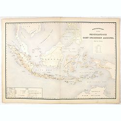
Overzichtskaart van den Nederlandsch oost Indischen Archipel.
Very detailed map of Indonesia, taken from "Atlas der Nederlandsche bezittingen in Oost-Indië", who was published by Departement van Koloniën". Including...
Place & Date: The Hague, 1883-1885
Selling price: $50
Sold in 2017
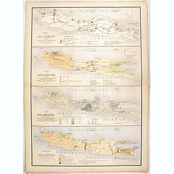
Kaart van Java en Madoera . . .
Four maps of Java and Madoera on one sheet taken from "Atlas der Nederlandsche bezittingen in Oost-Indië", who was published by Departement van Koloniën"...
Place & Date: The Hague, 1883-1885
Selling price: $55
Sold in 2017
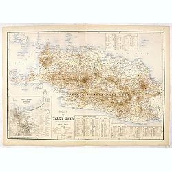
Kaart van West Java (eerste militaire afdeeling)
Very detailed map of west Java, taken from "Atlas der Nederlandsche bezittingen in Oost-Indië", who was published by Departement van Koloniën". With inse...
Place & Date: The Hague, 1883-1885
Selling price: $75
Sold in 2016
Kaart van Midden Java. ( tweede militaire afdeeling )
Very detailed map of central Java, taken from "Atlas der Nederlandsche bezittingen in Oost-Indië", who was published by Departement van Koloniën". In low...
Place & Date: The Hague, 1883-1885
Selling price: $50
Sold in 2016
Kaart van Oost Java. (derde militaire afdeeling.)
Very detailed map of East Java taken from "Atlas der Nederlandsche bezittingen in Oost-Indië", who was published by Departement van Koloniën". With large...
Place & Date: The Hague, 1883-1885
Selling price: $50
Sold in 2016
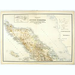
Kaart van Noord Sumatra: Gouvernement Atjeh en Onderhoorigheeden / Noordelijke gedeelten van de Res.n Tapanoeli en Sumatra's Oostkust / en de onafhankelijkeBatak Landen. . .
Very detailed map of Northen Sumatra, taken from "Atlas der Nederlandsche bezittingen in Oost-Indië", who was published by Departement van Koloniën".Firs...
Place & Date: The Hague, 1883-1885
Selling price: $50
Sold in 2023
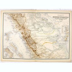
Kaart van Midden-Sumatra : Gouver.nt v. Sumatra's Westkust, Zuid ged. d. R. Sumatra's-Oostkust, Afd. Lingga v.d. Res. Riouw en Onderh. en het Rijk Djambi.
Very detailed map of Central Sumatra, taken from "Atlas der Nederlandsche bezittingen in Oost-Indië", who was published by Departement van Koloniën". Wit...
Place & Date: The Hague, 1883-1885
Selling price: $55
Sold in 2017
Kaart van Eiland Banka / Kaart van den Riouw en Lingga Archipels / Kaart van het Eiland Billiton.
Three very detailed maps of Banka Island, Billiton and the Riouw and Lingga Archipel, taken from "Atlas der Nederlandsche bezittingen in Oost-Indië", who was p...
Place & Date: The Hague, 1883-1885
Selling price: $40
Sold in 2016
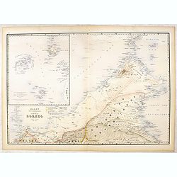
Kaart van Het Noordelijk Gedeelte Van Het Eiland Borneo.
Very detailed map of Northern Borneo, taken from "Atlas der Nederlandsche bezittingen in Oost-Indië", who was published by Departement van Koloniën".With...
Place & Date: The Hague, 1883-1885
Selling price: $125
Sold in 2016
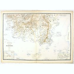
Kaart van het Zuidelijk Gedeelte Van het Eiland Borneo.
Very detailed map of Southern part of Bornea, taken from "Atlas der Nederlandsche bezittingen in Oost-Indië", who was published by Departement van Koloniën&qu...
Place & Date: The Hague, 1883-1885
Selling price: $40
Sold in 2020
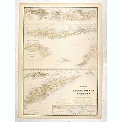
Kaart van de Kleine Soenda Eilanden.
Four very detailed maps of the Soenda Islands on one sheet taken from "Atlas der Nederlandsche bezittingen in Oost-Indië", who was published by Departement van...
Place & Date: The Hague, 1883-1885
Selling price: $50
Sold in 2016
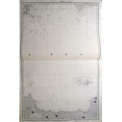
Sheet 2 (Western Route to China).
Impressively sized sea-chart of a part of the Java Sea. Shows Indramayu to Semarang on Java, the Karimunjawa Islands, a small part of Borneo, and a part of Belitung (Bill...
Place & Date: London, 1887
Selling price: $120
Sold in 2014
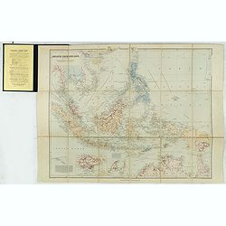
Asiatic Archipelago on Mercator's projection.
Charming, folding map of Indonesia, with Philippines, Papua new Guinea and inset maps of Singapore (80x12mm.) and Labuan (65x72mm.) a federal territory of Malaysia off th...
Place & Date: London, ca. 1890
Selling price: $350
Sold in 2015
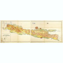
Geologische overzichtskaart van Java en Madoera in 12 bladen schaal 1: 500.00
Scarce geological map of Java and Madoera in a scale of 1:500.000 printed by Rogier Diederik Marius Verbeek (1845-1926) and Rinder Fennema (1849-1926). This is the rare w...
Place & Date: Amsterdam, 1896
Selling price: $400
Sold in 2016
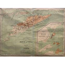
Provincia de Macau e Timor
A very rare map published by Companhia Nacional Editora ca. 1895. It shows the Portuguese colonies Timor and Macao in great detail. From 1844 until 1895 Timor was integra...
Place & Date: Lisbon, ca. 1896
Selling price: $130
Sold in 2021
Hinterindien und Malayischer Archipel.
Map of South East Asia with 4 insets. Shows settlements, roads, railways, telegraph cables, etc. A color key to Dutch, French, British, Portuguese occupations. Includes n...
Place & Date: Leipzig, 1905
Selling price: $100
Sold in 2020
Lot of 4 maps of South East Asia & Indonesia.
Collection of 4 late 19th or early 20th century maps of South East Asia, Japan & Korea, China, Singapore, and Indonesia.Detailed maps with many interesting features s...
Place & Date: c1880-1910
Selling price: $7
Sold in 2013
![Indonesia & Malaysia [epherma].](/uploads/cache/81165-250x250.jpg)
Indonesia & Malaysia [epherma].
Three early papers of Hotel des Indes, British India Steamer Baggage label to Yangon, and a hotel in Penang.Hotel des Indes was one of the oldest and most prestigious hot...
Place & Date: Anon, ca. 1920
Selling price: $75
Sold in 2018
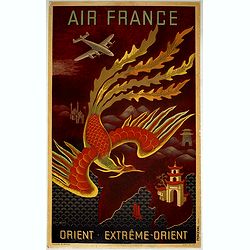
Near East - Far East.
AIR FRANCE poster promoting the airline's routes to the far east in the immediate post-war period. This is the full size version of Lucien Boucher's "phoenix" d...
Place & Date: Imprimerie Perceval Paris, ca. 1933
Selling price: $1000
Sold in 2019
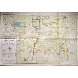
Carte Archeologique de la Region d'Angkor.
A detailed map of the region around Angkor Wat on a scale of 1:40,000, that includes a detailed key in the box at lower left corner. Includes the main ruins at Angkor Tho...
Place & Date: Anon, 1939
Selling price: $160
Sold in 2018
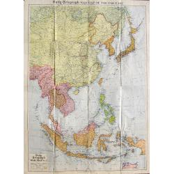
Daily Telegraph War Map of the Far East.
A very large folding map of South-East Asia from Russia until a tip of Australia. Shows transportation routes with distances, oil fields, Allied Naval Bases, and the terr...
Place & Date: London, ca. 1940
Selling price: $40
Sold in 2018
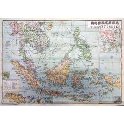
The Map of the East Indies.
A rare map of the East Indies issued by the Singapore branch of the World Book Company, one of China's major bookstores, and edited by Kying Wa Wang and Guan Ching Shy, a...
Place & Date: Singapore, 1941
Selling price: $145
Sold in 2018
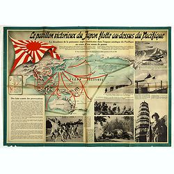
Le pavillon victorieux du Japon flotte au dessus du Pacifique (THE VICTORIOUS FLAG OF JAPAN FLIES OVER THE PACIFIC).
Cartographic propaganda World War II & the Japanese empire. A magnificent large-format propaganda broadside, or ‘wall newspaper’ made in December 1942, during Wor...
Place & Date: Spain, 1942
Selling price: $95
Sold in 2019
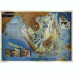
Nav War map No.2 The South China Sea Area.
An unusual and large colored lithograph Pictorial Map of the area around the South China Sea, distributed by the Educational Service Section, Bureau of Naval Personnel, N...
Place & Date: Washington, 1944
Selling price: $1500
Sold in 2017
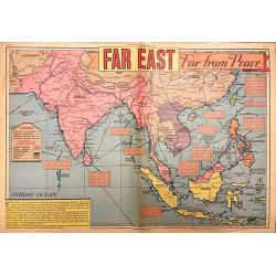
Far East Far from Peace.
A detailed map of the Far East drawn by Edwin L. Sundberg, celebrated staff artist of the Sunday News, from the January 26, 1946 issue. This rare piece of ephemera highli...
Place & Date: New York, 1946
Selling price: $250
Sold in 2018
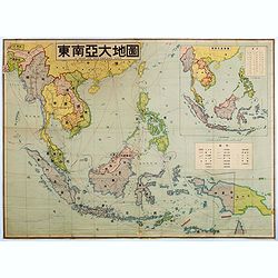
A map of southeast Asia.
Large color-printed map of South East Asia and centered on Philippines and Singapore. With inset map in the upper right corner. Showing railroad systems, maritime steambo...
Place & Date: China, ca. 1948
Selling price: $1150
Sold in 2016
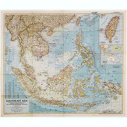
Southeast Asia Compiled and Drawn in the Cartographic Section of the National Geographic Society for the National Geographic Magazin Gilbert Grosvenor. . .
Map of the Southeast Asia, with inset map of Taiwan an map with Australia. The first issue of National Geographic Magazine was published on September 22, 1888, nine month...
Place & Date: Washington, 1952
Selling price: $50
Sold in 2018
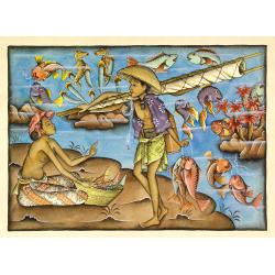
Balinees watercolor on paper, fishermen.
Decorative export painting from Bali of a more than average quality.
Place & Date: Bali, ca 1960
Selling price: $150
Sold in 2014
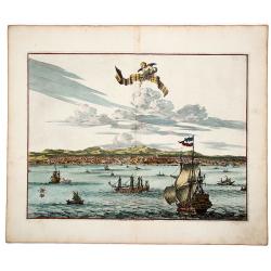
La Ville de l' AMBOINE, Capitale des Isles Molucques.
An attractive hand colored copperplate view of Ambon (Moluccas) by Pierre van der Aa. Shows the capital of Ambon Island with several ships in foreground during the the Du...
Place & Date: Leiden, ca 1719
Selling price: $100
Sold in 2019
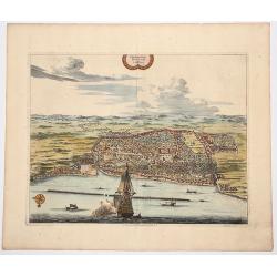
Plan de la Ville de BANTAM, dans l'isle de Java.
An attractive hand colored copperplate view of Bantam by Pierre van der Aa. Shows the village with several ships in foreground during the the Dutch 'golden age' in Indone...
Place & Date: Leiden, ca 1719
Selling price: $150
Sold in 2019