Browse Listings in Asia > Near / Middle East
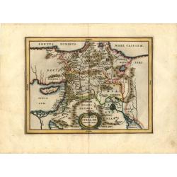
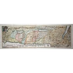
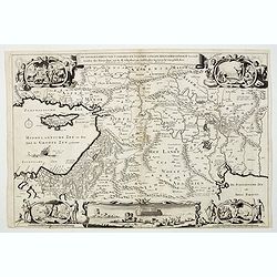
Armenia Syria, Mesopotamia etc.
This little map covers the region between the Black and Caspian Seas in the north, and from Egypt to the Persian Gulf in the south. It is finely engraved to show mountain...
Place & Date: Amsterdam, 1661
Selling price: $150
Sold in 2008
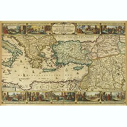
Geographifche Beschryvinghe van de Wandeling..
Title: "Geographifche Beschryvinghe van de Wandeling der Apostelen ende De Reysen Pauli"This is an original map from a Dutch bible of 1663 made by Visscher. col...
Place & Date: Amsterdam 1663
Selling price: $200
Sold
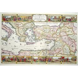
Geographische Beschryvinghe van de Wandeling der Apostelen ende De Reysen Pauli. . .
A decorative map of the eastern Mediterranean from Rome through Asia Minor and the Holy Land, depicting the route of Apostle Paul, including Italy, Sicily, Cyprus, Turkey...
Place & Date: Amsterdam, 1663
Selling price: $300
Sold in 2012
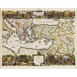
De Gelegenheyt van 't Paradys en 't Landt Canaan, mitsgaders de eerste bewoonde landen der Patriarchen? door Nicolaes Visscher.met Privilege vande Groot Mog: Heeren van Hollandt en West-Frieslandt voor 15 Jaaren. Broeck sculpsit.
Dutch so-called ' Staten' bibles, published between 1637 and c. 1760, contained 5 maps: The World, ' Paradise', The Perigrinations, The Promised Land Canaan, The Travels ...
Place & Date: Amsterdam, 1664
Selling price: $375
Sold
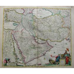
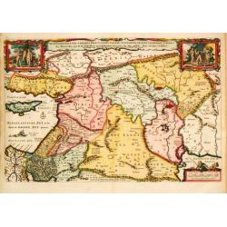
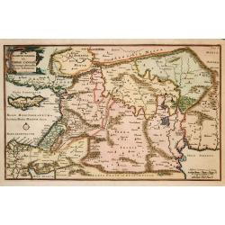
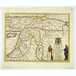
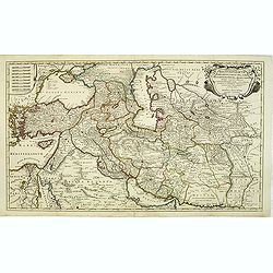
Nova Persiae Armeniae Natoliae et Arabiae.
Decorative map of Persia with Cyprus.
Place & Date: Amsterdam, 1670
Selling price: $500
Sold in 2010
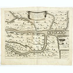
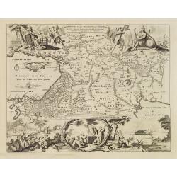
![[Lot of 2 maps] Perigrinatie ofte Veertich-Jarige Reyse der Kinderen Israëls.](/uploads/cache/20401-(2)-250x250.jpg)
[Lot of 2 maps] Perigrinatie ofte Veertich-Jarige Reyse der Kinderen Israëls.
Perigrinatie ofte Veertich-Jarige Reyse der Kinderen Israëls, Uyt Egypten door de Roode Zee, ende Woestyne, tot in 't Beloofde Land Canaan.Middelantsche Zee in den Bijb...
Place & Date: Amsterdam, c. 1670
Selling price: $300
Sold in 2023
Vera delineatio civitatis Bassoræ : Nec non Fluviorum, Insularum Oppidorum pagorum et terrarum ei adiacentium, inquibus passim habitant familiæ sabaorum Siue Mendaiorum, qui vulgo vocantur christiani sti. Joannis.
Rare map of the Tigris and Euphrates rivers in the area surrounding modern-day Basra published from 1672 onwards in "Relations de Divers Voyages Curieux" by the...
Place & Date: Paris, 1672
Selling price: $50
Sold in 2015
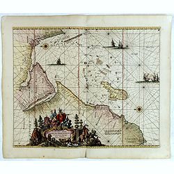
Occidentalior Tractus Indiarum Orientalium.
Decorative chart showing the coastlines of the Arabian peninsula with both the Red Sea and Persian Gulf shown in full. Africa from the Cape of Good Hope to Cape Comorin i...
Place & Date: Amsterdam, 1675
Selling price: $2000
Sold in 2018
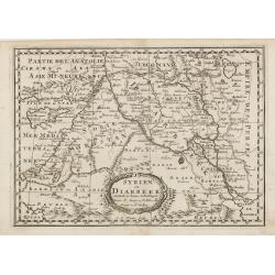
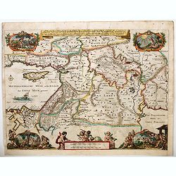
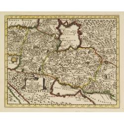
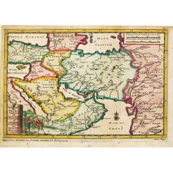
Syrien en Diarbeek verdeelt in hunne Scheidingen.
Engraved map of the Near East, including Cyprus, Palestine, Syria, Iraq, bordered by Greece, Turkey and Iran. The map shows great detail of towns, cities and topography, ...
Place & Date: Utrecht, 1680
Selling price: $70
Sold in 2016
De Beschrijvingh van de Reysen Pauli..
Decorative map with 8 insets depicting the wanders of Paulus and the Apostles. Dutch text on verso. Covers the territory from Sicily in the Mediterranean Sea to the Persi...
Place & Date: Amsterdam 1682
Selling price: $200
Sold
Beschryvinge van den Oorsprong der Volkeren, Uit de drie..
A very decorative map of the region from the Mediterranean through to the Persian Gulf, including Cyprus.The map depicts the Garden of Eden, Abraham's route from Ur, and ...
Place & Date: Amsterdam, 1687
Selling price: $170
Sold
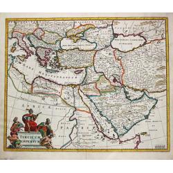
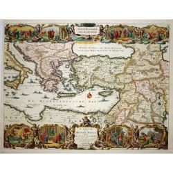
Turcicum Imperium.
Frederick de Wit (1610-1698) became after the closing of the Blaeu firm one of the most important Amsterdam-based publishers. He published several atlases, Atlas Minor (1...
Place & Date: Amsterdam, 1690
Selling price: $475
Sold
Die Legend des tradition Paradiesis und des Landes Canaan. . .
A handsome late seventeenth century map of 'Earthly Paradise', comprising the Holy land and the Middle East. The map extends from modern-day southern Turkey and Cyprus, e...
Place & Date: Amsterdam, ca 1690
![[Globe gore of the Black Sea, with Russia, Georgia, Cyprus and Gulf of Bassora]](/uploads/cache/29159-250x250.jpg)
[Globe gore of the Black Sea, with Russia, Georgia, Cyprus and Gulf of Bassora]
Half-gore from his 110 centimetres in diameter globe of 1688 with Cyprus, part of Egypt, Saudi Arabia, Crimea, Russia including Ukraine and Moscow. Some of the half-gores...
Place & Date: Venice, 1696
Selling price: $1450
Sold in 2010
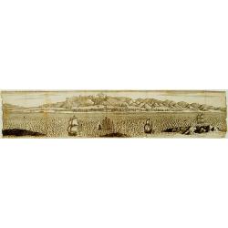
-250x250.JPG)
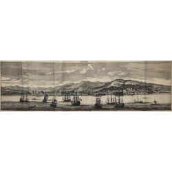
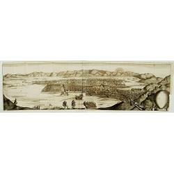
Aleppo
Very large 17th century copper engraving with a panoramic view of the city of Aleppo in Syria. The image is one of the largest of the former capital of Syria,showing th...
Place & Date: Amsterdam, 1698
Smyrna
A grand view at the city of Izmir in Turkey (the former Smyrna) as seen from the Mediterranean Sea at the end of the 17th century. After a drawing from nature by Cornelis...
Place & Date: Amsterdam, 1698
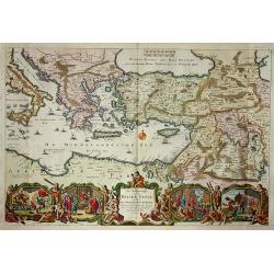
Persia sive Sophorum regnum cum Armenia Assyria Mesopotamia et Babylonia.
Uncommon map of the Near East, including Cyprus, Holy Land, Armenia, etc.
Place & Date: Amsterdam, 1700
Selling price: $30
Sold in 2008
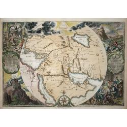
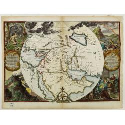
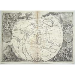
Orbis Per Creationem Institutus.
This is a very unusual map depicting the region from Asia Minor to India and including all of the Arabian Peninsula within a circle. The Garden of Eden is prominently dis...
Place & Date: Amsterdam, 1700
Selling price: $480
Sold in 2009
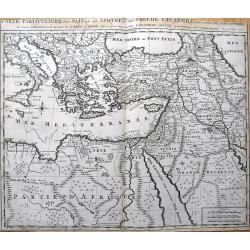
Carte Particuliere des Pais ou Les Apotres ont Preche l'Euan Gile; des Lieux les Plus Renommez de Leurs Voyages, et de la Route de St. Paul a Rome.
Detailed map of the Mediterranean and Middle East, illustrating the travels of St. Paul as he journeyed from Jerusalem to Rome. Very detailed, with numerous place names...
Place & Date: Amsterdam, c1700
Selling price: $90
Sold in 2013
Orbis Per Creationem Institutus.
This is a very unusual map depicting the region from Asia Minor to India and including all of the Arabian Peninsula within a circle. The Garden of Eden is prominently dis...
Place & Date: Amsterdam, 1700
Selling price: $650
Sold in 2019
Theatrum Historicum.. Tu Imperii Romani.. Pars Orientalis..
Showing the Eastern part of the Roman Empire, extending from Greece and Cyprus to India and centered on Armenia and the Black and Caspian Seas. Prepared by G. de l'Isle, ...
Place & Date: Paris, 1705
Selling price: $200
Sold in 2009
Reys-togt door Thomas Coryat van Jerusalem te Land gedaan na Asmere de Ho-Stadt des Grooten Mogols in Oostindien.
Pieter van der Aa was a prolific publisher. He published a.o. ' Naaukeurige versameling der gedenkwaardigste zee- en land-reysen', a series of accounts of voyages (1706-0...
Place & Date: Leiden, 1707
Selling price: $200
Sold
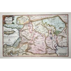
Descriptio Paradisi..
Nice map of the Middle East from the Mediterranean Sea to the Persian Gulf. The Garden of Eden is located in present-day Iraq, near the city of Babylon. Abraham's journey...
Place & Date: Utrecht, 1709
Selling price: $90
Sold in 2009
Tabula Geographica Terrae Sanctae Auctore J. Bonfrerio Societa Jesu.
This uncommon map of Israel is by the Flemish theologian, Jacques Bonfrere. Oriented with north at top left, it is divided into the Twelve Tribes with a key at bottom. Th...
Place & Date: Utrecht, 1709
Selling price: $310
Sold in 2009
Descriptio Paradisi..
Nice map of the Middle East from the Mediterranean Sea to the Persian Gulf. The Garden of Eden is located in present-day Iraq, near the city of Babylon. Abraham's journey...
Place & Date: Utrecht 1709
Selling price: $90
Sold in 2009
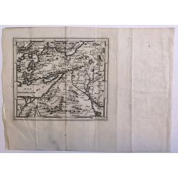
Untitled
A rare map of the Middle East region by Medrano. Engraved by Debruslins. Sheet size: 26.9cm x 19.5cm. Map size: 14.9cm x 13cm.
Place & Date: 1709
Selling price: $50
Sold in 2016
No title.
A fine and rare panoramic view of a town in the Near East. With extensive shipping on the foreground. From the Voyage de M. le Chevalier Chardin en Perse, et autres lieux...
Place & Date: Paris,1710
Selling price: $50
Sold in 2012
No title.
From the Voyage de M. le Chevalier Chardin en Perse, et autres lieux de l'Orient.Panoramic view of a city in the Near East.
Place & Date: Paris, 1710
Selling price: $60
Sold in 2012
A New Map of The Eastern Parts of Asia Minor. . .
A very pleasant map showing eastern Turkey, Cyprus, the Holy Land, Armenia, Lebanon, Syria, and Iraq. Map features a decorative title cartouche, and the heraldic arms of ...
Place & Date: Oxford, ca. 1712
Selling price: $55
Sold in 2018
De Beschryvingh van de Reysen Pauli.
Title: De Beschryvingh van de Reysen Pauli en van de andere apostelen.This is an original map from a Dutch Keur bible of 1714. colorful map of the eastern Mediterranean f...
Place & Date: Amsterdam 1714
Selling price: $180
Sold
Orbis Per Creationem Institutus. . .
An uncommon Dutch Bible map of the Middle East and Holy Land, including a map of Paradise, a map of the Exodus, a map of Israel divided among the Tribes, a map of Canaan,...
Place & Date: 1715
Selling price: $180
Sold in 2010
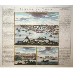
Bosphore de Thrace
This handsome folio sheet present three views of the strategically important Bosporus. At top is a large decorative bird's-eye view of Istanbul as viewed from across the ...
Place & Date: Amsterdam, 1719
Selling price: $350
Sold in 2009
The Travels of st. Paul ..
Around 1655 Moxon (1627-1700 ) visited Amsterdam, probably to learn from the Dutch if there was a northern passage to the Indies. In Amsterdam he met father Claes and son...
Place & Date: London 1720
Selling price: $410
Sold
De Beschryving van de Rysen Pauli..
Highly decorative map of the eastern part of the Mediterranean. At the bottom are a cartouche and four vignettes with episodes from the travels of the Apostle Paul.
Place & Date: Amsterdam, 1720
Selling price: $200
Sold
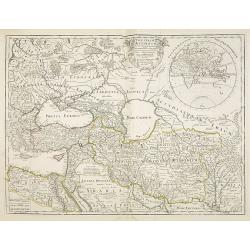
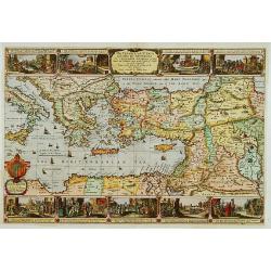
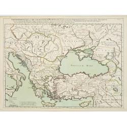
Regnum Persicum Imperium Turcicum in In Asia Russorum Provinciae ad Mare Caspium . . .
Striking map of the region bounded by Cyprus and the Eastern Mediterranean, the Nile, Medina, the Persian Gulf and the Indus River in the south and the Black Sea, Circass...
Place & Date: Amsterdam, 1720
Selling price: $400
Sold in 2012
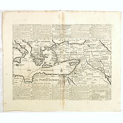
Carte historique et géographique pour servir à l'Histoire Sainte et à la Vocation de Saint Paul, avec quelques remarques curieuses pour servir à l'Histoire des Antiquités judaïques.
Interesting sheet with a map of the travels of Saint Paul, including eastern part of Europe, Asian continent and part of north Africa, with descriptive French text, from ...
Place & Date: Amsterdam, 1720
Selling price: $50
Sold in 2016
Imperii Orientalis Circumjacenttium..Constantiono..
Including Greece, Cyprus, Ukraine, Moldavia and the Black Sea.
Place & Date: Paris, 1722
Selling price: $450
Sold in 2008
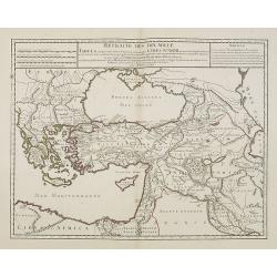
Retraite des Dix Mille Tabula conspectum exhibens Regionum omnium quas Cyrus Junior, Artaxerxi fratibellum illaturus ac Cyro in acie caeso. . .
Depicting ancient Turkey and Greece, including Cyprus, Black Sea, Iraq and Persia.
Place & Date: Paris, 1723
Selling price: $100
Sold in 2008
De Gelegentheyt van t' Paradys en t' Landt Canaan, mitsgaders d' eerst bewoonde Landen der Patriarchen.
Dutch so-called ' Staten' bibles, published between 1637 and c. 1760, contained 5 maps: The World, ' Paradise', The Perigrinations, The Promised Land Canaan, The Travels ...
Place & Date: Amsterdam, Pieter en Jacob Keur, 1729
Selling price: $250
Sold
De Gelegentheyt van 't Paradys ende 't Land Canaan mitsgaders de eerste. . .
Daniel Stoopendaal's splendid map of the region between the Holy land and the Persian Gulf; takING in countries like Israel, Cyprus, Egypt, Lebanon, Palestine, Jordan, Sy...
Place & Date: Amsterdam, ca 1730