Browse Listings in Asia > Near / Middle East
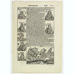
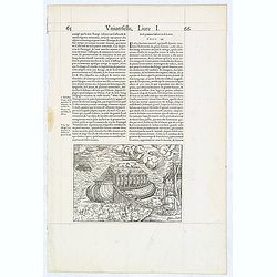
Quinta Etas Mudi. Folium.LXV (Babylon)
The Latin text page is illustrated with an imaginary of the Ancient City of Babylon (Dim. H : 138 mm W : 223 mm).VERSO are portraits of poets and teachers.Page from the ...
Place & Date: Nuremberg, 12 July 1493
Selling price: $100
Sold in 2011
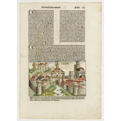
Secunda Etas Mundi. Ninive Folio XX. (With view of city of Ninive, in the northern part of Iraq.)
A imaginary but very nice presentation of the city of Ninive, in the northern part of Iraq. Verso, a genealogy of Nachorve, Job, Bethuel, Rebecca, Caleth, etc. Page from ...
Place & Date: Nuremberg, 12 July 1493
Selling price: $300
Sold in 2020
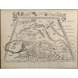
Tabu. VII Asiae
Trapezoidal Ptolemaic woodcut map showing the area around the Caspian Sea. A reduced version of Martin Waldseemullers Ptolemy map from 1513. From the 1525 Strasbourg Edit...
Place & Date: Strasbourg, 1525
Selling price: $1000
Sold in 2010
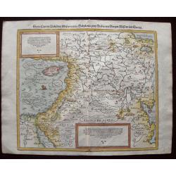
ASIAE TABULA quinta continentur Assyria...
This map covers the territory delimited by the Tigris and the Euphrates rives, the so called Mesopotamia.It extends as far as the borders with Iran, the eastern part of T...
Place & Date: Vienne, 1541
Selling price: $300
Sold
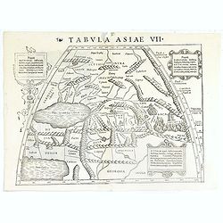
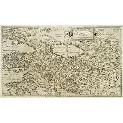
Tabula Asiae VII.
Attractive woodblock map, depicting to the left Persian Gulf and Caspian Sea according to Ptolemy. The mountain ranges are depicted in the manner of the early Ptolemaic f...
Place & Date: Basle, 1542
Selling price: $160
Sold in 2019
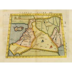
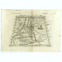
Tabula Asiae IIII.
Uncommon first edition of this classical map of the Holy Land, including Cyprus. The map is an enlarged version of Giacomo Gastaldi's published in 1548Girolamo Ruscelli's...
Place & Date: Venice, 1561
Selling price: $700
Sold in 2011
![[untitled] Judaea, Chaldaea, Syria, Mesopotamia, Asia Minor, Dioscurias, Mecha, Arabia Felix, Saba et al](/uploads/cache/85878-250x250.jpg)
[untitled] Judaea, Chaldaea, Syria, Mesopotamia, Asia Minor, Dioscurias, Mecha, Arabia Felix, Saba et al
Johannes Honter was a Protestant reformer from Transylvania, mentioned in 1570 by Abraham Ortelius in his ground-breaking atlas. Honter’s 'Rudimentorum Cosmographicorum...
Place & Date: Zurich, 1564
Selling price: $300
Sold in 2021
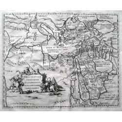
![[untitled] Asia Minor](/uploads/cache/85879-250x250.jpg)
[untitled] Asia Minor
From the 'Rudimentorum Cosmographicorum...', depicting Mesopotamia and West of Euphrates till Antiochia, Damaskus, Ammonitae; verso right map of the Middle East from ...
Place & Date: Zurich, 1564
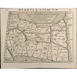
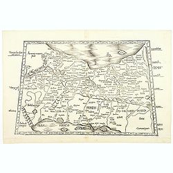
Tabula Asiae V
Woodcut map showing Persia between Persian Gulf and Caspian Sea. From the Latin 1571 edition of Strabo's Geographia with maps of Sebastian Munster which appeared in Ptole...
Place & Date: Basle, 1571
Selling price: $300
Sold in 2013
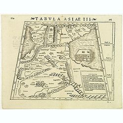
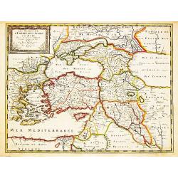
Tabula Asiae III
Attractive woodblock Ptolemaic map, depicting Armenia and in the Right part of the Caspian Sea with Noes Arch. The mountain ranges are depicted in the manner of the early...
Place & Date: Basle, Strabo, 1571
Selling price: $250
Sold in 2012
(Arch of Noah.)
Wood block engraved print of the Arch of Noah, from "La Cosmographie Universelle de Tout le Monde", the French and most extended edition of Sebastian Münster's...
Place & Date: Paris, Nicolas Chesneau, 1575
Selling price: $75
Sold in 2014
Syria, Cypern, Palestina, Mesopotamia, Babylonia, zwey Arabia mit Bergen, Waesseren und Stetten.
A famous woodblock map of the Near East, including Cyprus, Palestine, Iran, Iraq, etc. From his 'Cosmographia,' that great compendium of Renaissance knowledge. In 1588, n...
Place & Date: Basle, S.H. Petrie, 1588
Selling price: $110
Sold in 2014
![[Lot of 11 maps of Persia] Reyno de Persia, o imperia de los Sophies/ Pereici sive Sophorum Regni Ypus](/uploads/cache/18512-(3)-250x250.jpg)
[Lot of 11 maps of Persia] Reyno de Persia, o imperia de los Sophies/ Pereici sive Sophorum Regni Ypus
Abraham Ortelius( 1527-98), Dutch cartographer and publisher of the first modern atlas, ' Theatrum Orbis Terrarum' in 1570. Editions till 1612. Also an atlas of ancient c...
Place & Date: Antwerp, c. 1590
Selling price: $325
Sold in 2022
![[Set of 5 maps of the Holy Land: Paradise, Canaan, Israel & Egypt, the Eastern Mediterranean. . .]](/uploads/cache/48407-250x250.jpg)
[Set of 5 maps of the Holy Land: Paradise, Canaan, Israel & Egypt, the Eastern Mediterranean. . .]
A lovely set of biblical maps of the Holy Land and its surrounds and, the Eastern Mediterranean by Cloppenburg, and engraved by Baptista Deuticum. The first map is an ear...
Place & Date: Amsterdam, ca 1590
Selling price: $1700
Sold in 2022
Primae Partis Asiae.
Includes the eastern part of the Mediterranean with Cyprus and Holy Land and the Black Sea with Turkey in between, the northern part of Egypt, Arabia Persia and Afghanist...
Place & Date: Antwerp 1593
Selling price: $1475
Sold
Natoliam Moderni dicunt tam partem quam Asiam minrem appelauere veteres. (with Cyprus).
Engraved by Van Deutecum, this is a spectacular example of the 1593 edition of the very rare De Jode's map of the Eastern Mediterranean and Asia Minor. It has two title c...
Place & Date: Antwerp, 1593
Selling price: $3900
Sold in 2014
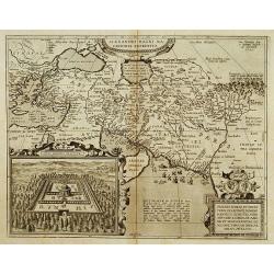
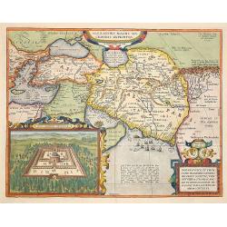
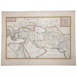
Alexandri Magni Maredonis Expeditio.
Handsomely engraved map of Alexander the Great's Empire at full flower, with a large inset depicting the Temple of the Oracle of Jupiter Amman, supposedly situated in pre...
Place & Date: Antwerp 1595
Selling price: $360
Sold
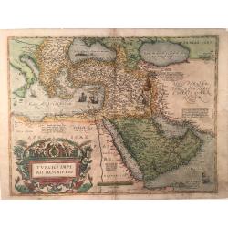
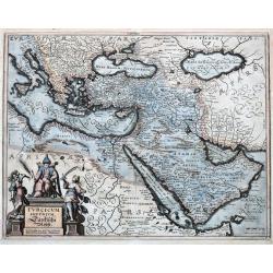
Turcici Imperii Descriptio
This is the second map by Ortelius depicting the Turkish Empire, based on Ortelius' own map of Asia, derived from the work of Giacomo Gastaldi of 1561. It features the Ar...
Place & Date: Antverpen, ca 1595
Selling price: $472
Sold in 2023
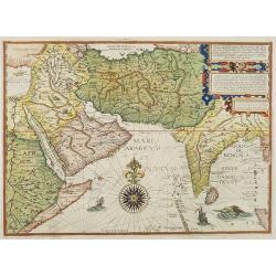
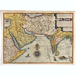
Afbeeldinge der custen van Abex, der engte van Mecha..
A highly decorative and distinctive map showing eastern Africa, Arabia, Persia and India. Around India several manuscript annotations in brown ink. With rhumb lines and d...
Place & Date: Amsterdam 1596
Selling price: $2000
Sold
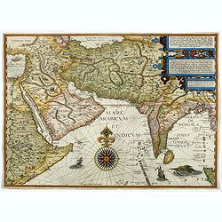
Afbeeldinge der custen van Abex, der engte van Mecha..
A highly decorative and distinctive chart showing eastern Africa, Arabia, Persia and India, with rhumb lines and decorative compass roses in sea areas. A lion, elephant a...
Place & Date: Amsterdam, 1596
Selling price: $2300
Sold in 2008
Afbeeldinge der custen van Abex, der engte van Mecha..
A highly decorative and distinctive map showing eastern Africa, Arabia, Persia and India, with rhumb lines and decorative compass roses in sea areas. A lion, elephant and...
Place & Date: Amsterdam, after 1596
Selling price: $3500
Sold in 2014
Afbeeldinge der custen van Abex, der engte van Mecha..
A highly decorative and distinctive map showing eastern Africa, Arabia, Persia and India. Around India several manuscript annotations in brown ink. With rhumb lines and d...
Place & Date: Amsterdam, 1596
Selling price: $4800
Sold in 2017
Tabula Asiae III.
The third state of Ruscelli's map of the region between the Black Sea and Caspian Sea extending south to include all of Armenia Maior and part of Armenia Minoris, based u...
Place & Date: Venice, 1598
Selling price: $80
Sold in 2018
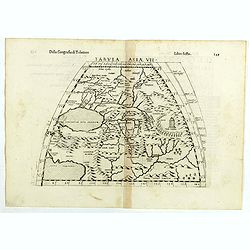
Tabula Asiae VII.
The third state of Ruscelli's map the region north and east of the Black Sea and Caspian Sea, extending to the Imaus Mountains, based upon Claudius Ptolemy. Showing Caspi...
Place & Date: Venice, 1598
Selling price: $80
Sold in 2018
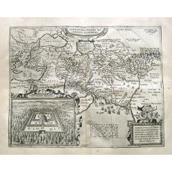
Alexandri Magni Marcedonis Expeditio.
Handsomely engraved map of Alexander the Great's Empire at full flower, with a large inset depicting the Temple of the Oracle of Jupiter Amman, supposedly situated in pre...
Place & Date: Antwerp 1603
Selling price: $850
Sold
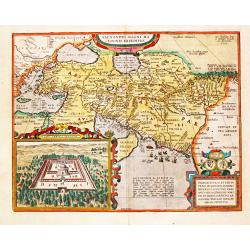
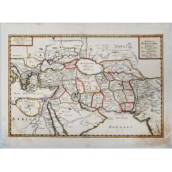
Alexandri Magni Macedonis Expeditio
Detailed map of Alexander the Great's expedition to the Middle East and Persia. The map extends from Greece until east of the Indus river.With a large inset: Iovis Ammoni...
Place & Date: Antwerp, 1603
Selling price: $475
Sold in 2019
Alexandri Magni Macedonis Expeditio. - Iovis Ammonis Oraculum. 1595.
Alexandri Magni Macedonis Expeditio - Iovis Ammonis Oraculum. 1595.Abraham Ortelius (1527-98), Dutch cartographer and publisher of the first modern atlas, ' Theatrum Orb...
Place & Date: Antwerp, 1607
![[Babylon]](/uploads/cache/90737-250x250.jpg)
[Babylon]
Rare woodcut view of the Tower of Babel, Babylon. From "Parvum Theatrum Urbium sive Urbium Praecipuarum totius orbis Brevis & Methodica Descriptio" by Adria...
Place & Date: Frankfurt, 1608
Selling price: $130
Sold in 2009
Alexandri Magni Expeditio.
Early map of travels of Alexander the Great. Including the Near East and a small inset of Eastern part of Turkey.From the first French-text edition of Jodocus Hondius' At...
Place & Date: Amsterdam, 1608
Selling price: $120
Sold in 2010
Mesopotamia Syrie.
This scarce map of the Eastern Mediterranean region extends throughout the Middle East and Egypt. Cyprus and the Levantine coasts are clearly detailed with particular att...
Place & Date: Hannover 1611
Selling price: $500
Sold
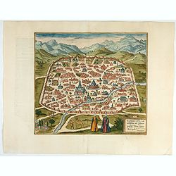
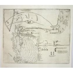
Damascus – Urbs Nobilissima ad Libanum Montem, Totius Syriae Metropolis.
Striking town plan of Damascus shows the fortified walls of the City and various buildings, public squares and other places of interest, with costumed locals and camels i...
Place & Date: Cologne, 1618
Selling price: $400
Sold in 2023
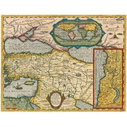
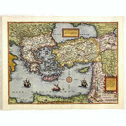
Lumen Historiarum per Orientem.
The Rare Ortelius Middle East map from the 'Parergon.' In the upper right corner is an inset with a world map.The map is surrounded by letterpress explanatory text with p...
Place & Date: Antwerp, 1624
Selling price: $1150
Sold in 2009
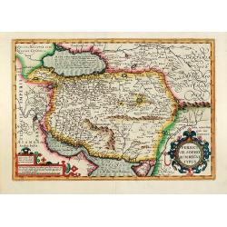
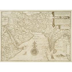
Persici vel Sophorum Regni typus
Hand colored copper map of Persia by G. Mercator. With two beautiful colored cartouche. Covering the area of today Iran with the Caspian Sea and the Persian Gulf. From a ...
Place & Date: Amsterdam, 1628
Selling price: $400
Sold in 2011
Turcicum Imperium.
Merian's map of the Turkish Empire, showing the area from Sicily and Italy until the Caspian Sea, the Gulf of Aden, the Red Sea, Socotra Island, and Saudi Arabia.
Place & Date: Frankfurt, ca.1636
Selling price: $66
Sold in 2021
Descriptio terrarum in quasdispersi sunt structores turris Babel.
SCARCE early map of the Mediterranean, the Middle East, and northern Africa. Many areas and coast lines distorted! The Near East is highly detailed with numerous ancient ...
Place & Date: Amsterdam, after1646
Selling price: $220
Sold in 2015
Les Estats de l' Empire des Turqs en Asie.
Nicolas Sanson (1600-67), ' father of the French cartography' and founder of the Sanson firm. Atlas ' Cartes générales de toutes les parties du Monde', 1658-70 and a po...
Place & Date: Paris, Pierre Mariette, c.1650
Selling price: $450
Sold in 2008
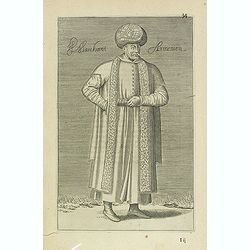
Marchant Armenien (34)
Sought-after copper engraved plate Plate from Laonikos Chalcocondyle’s "L'histoire de la décadence de l'empire grec et establissement de celuy des Turcs." by...
Place & Date: Paris, Mathieu Guillemot, 1650
Selling price: $100
Sold in 2012
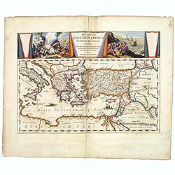
Descriptio Peregrinationis D. Pauli, Apostoli. . .
A striking map of the Mediterranean Sea and its surrounding areas. It depicts the travels of the Apostle St. Paul.The pair of decorative cartouches, presented in a curtai...
Place & Date: Amsterdam, 1650
Selling price: $191
Sold in 2017
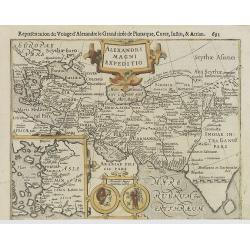
EXPEDITIONS ALEXANDRI MAGNI Per Europam, Assiam et Africam, Tabula Geographica.
A detailed outlined hand-colored map of the region bounded by the Eastern Mediterranean in the West and India in the east, centered on the Arabian Peninsula, Persia and I...
Place & Date: Paris, 1654
Selling price: $100
Sold in 2019
Expeditionis ALEXANDRI MAGNI Per Europa, Asiam et Africam.
Detailed, colored map of the region bounded by the Eastern Mediterranean in the West and India in the east, centered on the Arabian Peninsula, Persia and Iraq.
Place & Date: 1654
Selling price: $40
Sold in 2019