Browse Listings in Asia > Near / Middle East
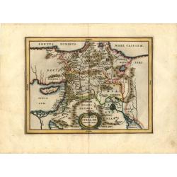
Armenia Syria, Mesopotamia etc.
This little map covers the region between the Black and Caspian Seas in the north, and from Egypt to the Persian Gulf in the south. It is finely engraved to show mountain...
Place & Date: Amsterdam, 1661
Selling price: $150
Sold in 2008
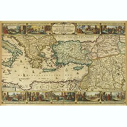
Geographifche Beschryvinghe van de Wandeling..
Title: "Geographifche Beschryvinghe van de Wandeling der Apostelen ende De Reysen Pauli"This is an original map from a Dutch bible of 1663 made by Visscher. col...
Place & Date: Amsterdam 1663
Selling price: $200
Sold
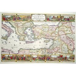
Geographische Beschryvinghe van de Wandeling der Apostelen ende De Reysen Pauli. . .
A decorative map of the eastern Mediterranean from Rome through Asia Minor and the Holy Land, depicting the route of Apostle Paul, including Italy, Sicily, Cyprus, Turkey...
Place & Date: Amsterdam, 1663
Selling price: $300
Sold in 2012
De Gelegenheyt van 't Paradys en 't Landt Canaan, mitsgaders de eerste bewoonde landen der Patriarchen? door Nicolaes Visscher.met Privilege vande Groot Mog: Heeren van Hollandt en West-Frieslandt voor 15 Jaaren. Broeck sculpsit.
Dutch so-called ' Staten' bibles, published between 1637 and c. 1760, contained 5 maps: The World, ' Paradise', The Perigrinations, The Promised Land Canaan, The Travels ...
Place & Date: Amsterdam, 1664
Selling price: $375
Sold
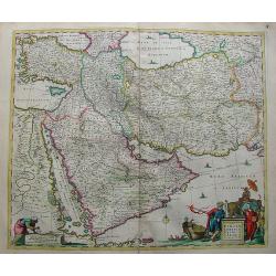
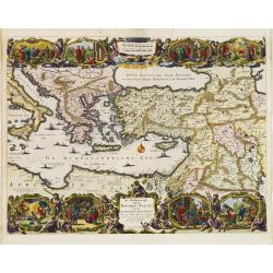
Nova Persiae Armeniae Natoliae et Arabiae.
Decorative map of Persia with Cyprus.
Place & Date: Amsterdam, 1670
Selling price: $500
Sold in 2010
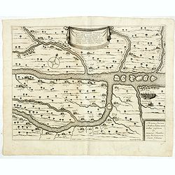
![[Lot of 2 maps] Perigrinatie ofte Veertich-Jarige Reyse der Kinderen Israëls.](/uploads/cache/20401-(2)-250x250.jpg)
[Lot of 2 maps] Perigrinatie ofte Veertich-Jarige Reyse der Kinderen Israëls.
Perigrinatie ofte Veertich-Jarige Reyse der Kinderen Israëls, Uyt Egypten door de Roode Zee, ende Woestyne, tot in 't Beloofde Land Canaan.Middelantsche Zee in den Bijb...
Place & Date: Amsterdam, c. 1670
Selling price: $300
Sold in 2023
Vera delineatio civitatis Bassoræ : Nec non Fluviorum, Insularum Oppidorum pagorum et terrarum ei adiacentium, inquibus passim habitant familiæ sabaorum Siue Mendaiorum, qui vulgo vocantur christiani sti. Joannis.
Rare map of the Tigris and Euphrates rivers in the area surrounding modern-day Basra published from 1672 onwards in "Relations de Divers Voyages Curieux" by the...
Place & Date: Paris, 1672
Selling price: $50
Sold in 2015
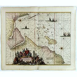
Occidentalior Tractus Indiarum Orientalium.
Decorative chart showing the coastlines of the Arabian peninsula with both the Red Sea and Persian Gulf shown in full. Africa from the Cape of Good Hope to Cape Comorin i...
Place & Date: Amsterdam, 1675
Selling price: $2000
Sold in 2018
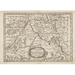
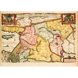
Syrien en Diarbeek verdeelt in hunne Scheidingen.
Engraved map of the Near East, including Cyprus, Palestine, Syria, Iraq, bordered by Greece, Turkey and Iran. The map shows great detail of towns, cities and topography, ...
Place & Date: Utrecht, 1680
Selling price: $70
Sold in 2016
De Beschrijvingh van de Reysen Pauli..
Decorative map with 8 insets depicting the wanders of Paulus and the Apostles. Dutch text on verso. Covers the territory from Sicily in the Mediterranean Sea to the Persi...
Place & Date: Amsterdam 1682
Selling price: $200
Sold