Browse Listings in Asia > Near / Middle East
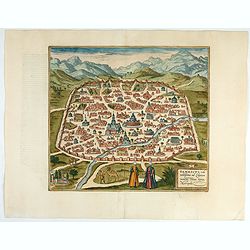
Damascus – Urbs Nobilissima ad Libanum Montem, Totius Syriae Metropolis.
Striking town plan of Damascus shows the fortified walls of the City and various buildings, public squares and other places of interest, with costumed locals and camels i...
Place & Date: Cologne, 1618
Selling price: $400
Sold in 2023
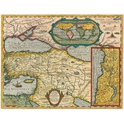
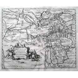
Lumen Historiarum per Orientem.
The Rare Ortelius Middle East map from the 'Parergon.' In the upper right corner is an inset with a world map.The map is surrounded by letterpress explanatory text with p...
Place & Date: Antwerp, 1624
Selling price: $1150
Sold in 2009
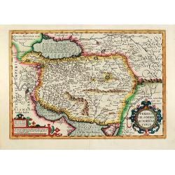
Persici vel Sophorum Regni typus
Hand colored copper map of Persia by G. Mercator. With two beautiful colored cartouche. Covering the area of today Iran with the Caspian Sea and the Persian Gulf. From a ...
Place & Date: Amsterdam, 1628
Selling price: $400
Sold in 2011
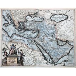
Turcicum Imperium.
Merian's map of the Turkish Empire, showing the area from Sicily and Italy until the Caspian Sea, the Gulf of Aden, the Red Sea, Socotra Island, and Saudi Arabia.
Place & Date: Frankfurt, ca.1636
Selling price: $66
Sold in 2021
Descriptio terrarum in quasdispersi sunt structores turris Babel.
SCARCE early map of the Mediterranean, the Middle East, and northern Africa. Many areas and coast lines distorted! The Near East is highly detailed with numerous ancient ...
Place & Date: Amsterdam, after1646
Selling price: $220
Sold in 2015
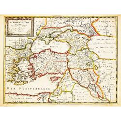
Les Estats de l' Empire des Turqs en Asie.
Nicolas Sanson (1600-67), ' father of the French cartography' and founder of the Sanson firm. Atlas ' Cartes générales de toutes les parties du Monde', 1658-70 and a po...
Place & Date: Paris, Pierre Mariette, c.1650
Selling price: $450
Sold in 2008
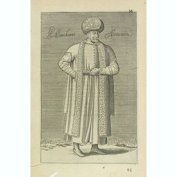
Marchant Armenien (34)
Sought-after copper engraved plate Plate from Laonikos Chalcocondyle’s "L'histoire de la décadence de l'empire grec et establissement de celuy des Turcs." by...
Place & Date: Paris, Mathieu Guillemot, 1650
Selling price: $100
Sold in 2012
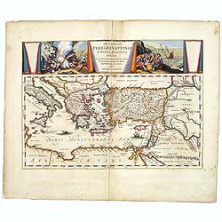
Descriptio Peregrinationis D. Pauli, Apostoli. . .
A striking map of the Mediterranean Sea and its surrounding areas. It depicts the travels of the Apostle St. Paul.The pair of decorative cartouches, presented in a curtai...
Place & Date: Amsterdam, 1650
Selling price: $191
Sold in 2017
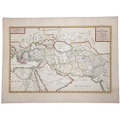
EXPEDITIONS ALEXANDRI MAGNI Per Europam, Assiam et Africam, Tabula Geographica.
A detailed outlined hand-colored map of the region bounded by the Eastern Mediterranean in the West and India in the east, centered on the Arabian Peninsula, Persia and I...
Place & Date: Paris, 1654
Selling price: $100
Sold in 2019
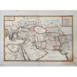
Expeditionis ALEXANDRI MAGNI Per Europa, Asiam et Africam.
Detailed, colored map of the region bounded by the Eastern Mediterranean in the West and India in the east, centered on the Arabian Peninsula, Persia and Iraq.
Place & Date: 1654
Selling price: $40
Sold in 2019