Browse Listings in Asia > Holy Land & Jerusalem
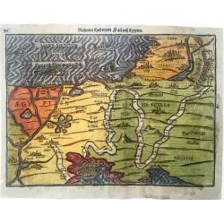
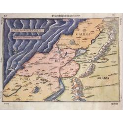
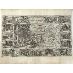
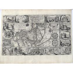
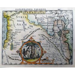
Reisen der Kinder von Israel aus Egypten
Very decorative example of Bünting's map of the Exodus of the Israelites from Egypt. This very detailed map shows the route of the Israelites in their Exodus from Egypt ...
Place & Date: Magdeburg, 1585
Selling price: $375
Sold in 2021
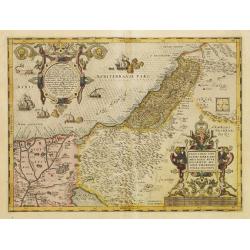
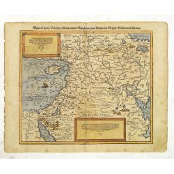
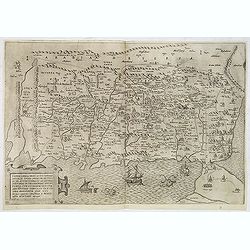
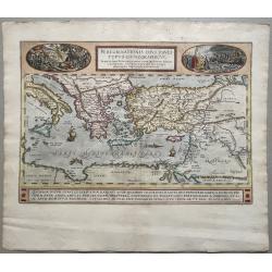
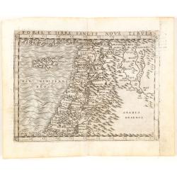
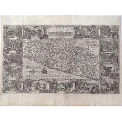
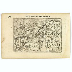
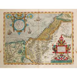
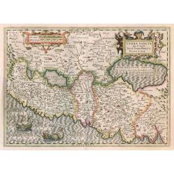
Palestinae sive totius terrae promissionis nova..
Ortelius famous map of Palestine based on Tilemann Stoltz\'s map, published in 1566. The shoreline runs from Berytus (Beirut) to the Nile Delta, reaching inland east of t...
Place & Date: Antwerp, 1587
Selling price: $900
Sold in 2008
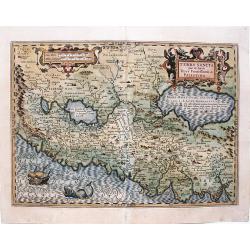
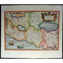
Palestinae sive totius terrae promissionis nova..
Ortelius famous map of Palestine based on Tilemann Stoltz's map, published in 1566. The shoreline runs from Berytus (Beirut) to the Nile Delta, reaching inland east of th...
Place & Date: Antwerp, 1587
Selling price: $750
Sold in 2014
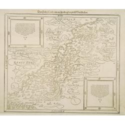
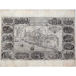
Das Heilig Landt mit auscheilung der zwolff Geschlechter.
The Holy Land as divided among the 12 Tribes. Although the title speaks about the Tribes, they are not shown on the map itself, only the division into Galilee, Samaria an...
Place & Date: Basle 1588
Selling price: $150
Sold
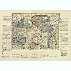
Syria, Cypern, Palestina, Mesopotamia..
A famous wood block map of the Near East, including Cyprus, Palestine, Iran and Iraq, etc. From his Cosmographia , that great compendium of Renaissance knowledge. In 1588...
Place & Date: Basle c.1588
Selling price: $210
Sold
Syria / Cypern / Palestina Mesopotamia / Babylonia / zwen Arabia / mit Bergen / Wasseren und Stetten.
A famous wood block map of the Near East, including Cyprus, Palestine, Iran and Iraq, etc. From his "Cosmographia", that great compendium of Renaissance knowled...
Place & Date: Basle, c.1588
Selling price: $200
Sold in 2012
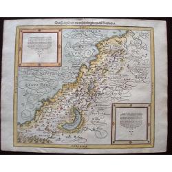
Das Heilig Landt mit Ausztheilung der Zwolff Geschlechter.
Classic woodblock map of the region showing numerous towns along the fertile coast and mountains, rivers and lakes. Although the title mentions the 12 tribes, they are no...
Place & Date: Basle, S.H. Petrie, 1588
Selling price: $200
Sold in 2014
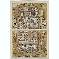
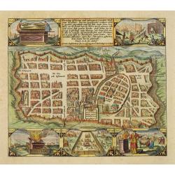
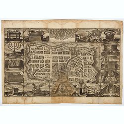
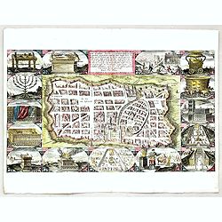
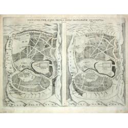
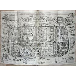
Ierusalem, et suburbia eius. . .
Plan of ancient Jerusalem and its suburbs as it looked at the time of Jesus Christ. TRANSLATION OF CAPTION: Jerusalem and its suburbs, as it flourished in the time of Chr...
Place & Date: Antwerp, 1588
Selling price: $2500
Sold in 2022
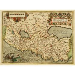
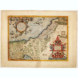
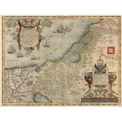
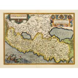
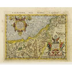
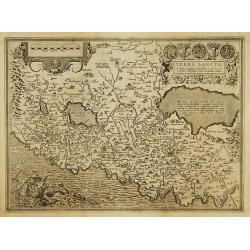
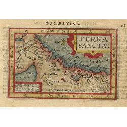
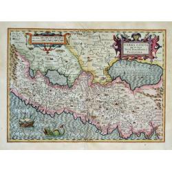
Terra Sancta.
This is the most modern of Ortelius' maps of the Holy Land. It focuses specifically on the Holy Land and is oriented with east of the top. Ortelius used as a model the wa...
Place & Date: Antwerp 1590
Selling price: $700
Sold
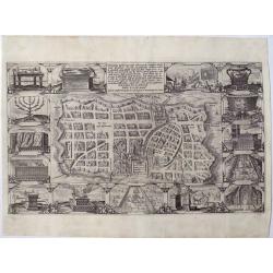
Waerachtige beschryvinge vande wydvermaerde Conincklicke Hooft Stadt Jerusalem..
Engraved by Baptista van Doetechum for a bible printed by Jan Everts Cloppenburg. The bible maps of 1590 are the earliest of Plancius compilations to survive.Very rare pl...
Place & Date: Amsterdam, 1590
Selling price: $800
Sold in 2008
Tabula Geographica, in qua omnes regiones, urbes, oppida..
Engraved by Baptista van Doetechum for a bible by van Liesvelt. The bible maps of 1590 are the earliest of Plancius compilations to survive. Very rare map of Palestine di...
Place & Date: Amsterdam 1590
Selling price: $1000
Sold
![In monte casio iuxta ostracinam. . . [Israel with Cyprus]](/uploads/cache/32575-250x250.jpg)
In monte casio iuxta ostracinam. . . [Israel with Cyprus]
On recto a woodcut engraved map of Israel and Cyprus. Engraved by Hans Rudolf Manuel Deutsch, with his monogram. From a Latin text edition of his Geographia , that great ...
Place & Date: Basle, 1550-1590
Selling price: $20
Sold in 2015
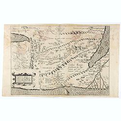
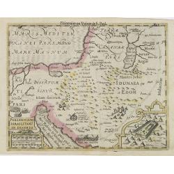
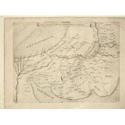
Pharan desertum, et confinia eius cum parte Aegypti, ea videlicet terrae regio . . .
Cristian van Adrichem's map of the Holy Land, depicting the Desert of Pharan or Paran and the Wandering of the Israelites. The map is oriented to the east and covers the ...
Place & Date: Amsterdam, 1590
Selling price: $90
Sold in 2020
![[Set of 5 maps of the Holy Land: Paradise, Canaan, Israel & Egypt, the Eastern Mediterranean. . .]](/uploads/cache/48407-250x250.jpg)
[Set of 5 maps of the Holy Land: Paradise, Canaan, Israel & Egypt, the Eastern Mediterranean. . .]
A lovely set of biblical maps of the Holy Land and its surrounds and, the Eastern Mediterranean by Cloppenburg, and engraved by Baptista Deuticum. The first map is an ear...
Place & Date: Amsterdam, ca 1590
Selling price: $1700
Sold in 2022
Waerachtige beschryvinge vande wydvermaerde Conincklicke Hooft Stadt Jerusalem. . .
A truly beautiful copper engraved plan of Jerusalem by Baptista van Doetechum for a bible printed by Jan Everts Cloppenburg. The bible maps of 1590 are the earliest of Pl...
Place & Date: Amsterdam, ca 1590
Selling price: $450
Sold in 2022
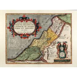
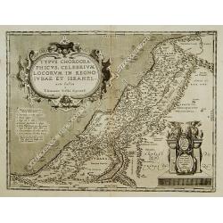
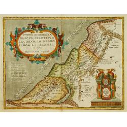
Typus chorographicus, celebrium locorum in regno Iudae et Israhel
Beautiful colored map of the Holy Land by A. Ortelius. The map is based on T. Stella's map of 1552, with two large Renaissance cartouches. From the 1592 Latin edition of ...
Place & Date: Antwerp, 1592
Selling price: $1000
Sold in 2010
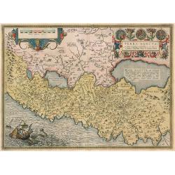
Terra Sancta.
Holy Land of the 'Theatrum Orbis Terrarum', described by Petrus Laicstain and designed by Chistian Schrot. Oriented to the east. Shows the shore line from Beirut to Gaza....
Place & Date: Antwerp, 1592
Selling price: $850
Sold in 2010
Palestinae sive totius terraepromissionis nova descriptio auctore tilemanno stella sigensis.
Holy Land from the 'Theartrum Orbis Terrarum'.
Place & Date: Antwerp, 1592
Selling price: $800
Sold in 2010
Theatrum Terrae Sanctae et Biblicarum Historiarum. Cum tabulis geographicis aere expressis
Second edition of the work about Palestine by Delft theologian Christian Adrichomius, first published 1590. With a Geography of Palestine, a description of Jerusalem and ...
Place & Date: Cologne, 1593
Selling price: $3200
Sold in 2009
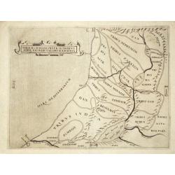
Terrae Israel omnis ante Canaan dictae in tribus undecim ... A. Bened. Aria Montano descripta.
Land of Israel, previously called Canaan, divided into 11 Tribes, showing also the neighboring regions and the 43 stations of the Israelites in the desert.The shore line ...
Place & Date: Antwerp, 1572 / Leiden, 1593
Selling price: $1000
Sold in 2020
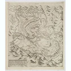
Antiquae Ierusalem vera icnographia ad Sacræ Lectionis Præ-cipue et Aliarum de Ila Urbe Historiar. Explicationem Ex collatione auctoru tu ruinaru uestigiis ac situ ipso.
An "imaginary typographic plan" of ancient Jerusalem. Delano-Smith & Ingram describe it as "east oriented with mountains ringing the city and closing t...
Place & Date: Antwerp, 1572 / Leiden, 1593
Selling price: $900
Sold in 2013
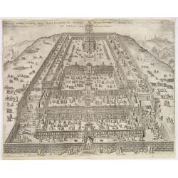
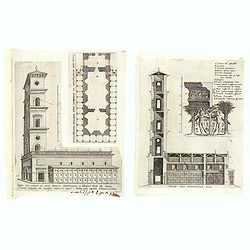
Montis Domini totiusque Sacri Templi exemplum ex antiquis descriptionibus a Bened Aria Montano observatis ad Apparatus Sacri. . .
Striking view of the Temple, filled with worshippers, merchants, soothsayers, cattle, sheep, poultry, etc.From Benedictus Arias Montanus' Antiquitatum Iudicarum Libri IX....
Place & Date: Antwerp, 1572 / Leiden, 1593
Selling price: $600
Sold in 2013
![Sacerdotis antiqui sanctis vestibus et ornamentis instructi exemplum / ex descriptione Mosis. . . [Hebrew priest]](/uploads/cache/33274-250x250.jpg)
Sacerdotis antiqui sanctis vestibus et ornamentis instructi exemplum / ex descriptione Mosis. . . [Hebrew priest]
Fine engraving of a Hebrew priest. From Benedictus Arias Montanus' Antiquitatum Iudicarum Libri IX. In quis, praeter Iudaeae, also in Liber Chanaan, and his rare Biblia P...
Place & Date: Antwerp, 1572 / Leiden, 1593
Selling price: $360
Sold
![[ The Israelites in their camp ]](/uploads/cache/33275-250x250.jpg)
[ The Israelites in their camp ]
Fine engraving of The Israelites in their camp. This plate was the frontispiece of Vol. VIII of the Polyglot Bible. From Benedictus Arias Montanus' Antiquitatum Iudicarum...
Place & Date: Antwerp, 1572 / Leiden, 1593
Selling price: $300
Sold in 2013
![[Schematic of the Temple in Jerusalem. ]](/uploads/cache/33278-250x250.jpg)
[Schematic of the Temple in Jerusalem. ]
Schematic of the Temple in Jerusalem.From Benedictus Arias Montanus' Antiquitatum Iudicarum Libri IX. In quis, praeter Iudaeae, also in Liber Chanaan, and his rare Biblia...
Place & Date: Antwerp, 1572 / Leiden, 1593
Selling price: $210
Sold in 2013
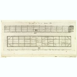
(2 prints) Sacrae aedis sciographiae pars. / Templi cum porticu et cellis absoluta orthographia ...
Two engraving from Arias Montanus, Benito "Antiquitatum Iudicarum Libri IX. In quis, praeter Iudaeae, Hierosolymorum, & Templi Salomonis accuratam delineationem,...
Place & Date: Antwerp, 1572 / Leiden, 1593
Selling price: $40
Sold in 2015
(The Ark.)
Engraving of The Ark of Moses from Arias Montanus, Benito "Antiquitatum Iudicarum Libri IX. In quis, praeter Iudaeae, Hierosolymorum, & Templi Salomonis accurata...
Place & Date: Antwerp, 1572 / Leiden, 1593
Selling price: $80
Sold in 2015
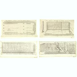
Sacri tabernaculi. . . (Four engravings of the Holy Tabernacle.)
Four engraving of the Holy Tabernacle from Arias Montanus, Benito "Antiquitatum Iudicarum Libri IX. In quis, praeter Iudaeae, Hierosolymorum, & Templi Salomonis ...
Place & Date: Antwerp, 1572 / Leiden, 1593
Selling price: $60
Sold in 2015
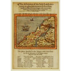
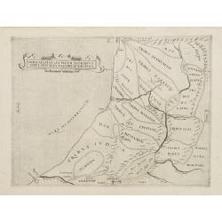
The description of the holy Land, conteining the places..
Description of the Holy Land, showing all the places mentioned in the Gospels and the itineraries of Jesus Christ and his disciples in Judea, Samaria, and Galilee. Shows ...
Place & Date: London 1595
Selling price: $350
Sold
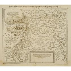
Typus chorographicus, celebrium locoum in regno Judae et..
Drawn by Tilemannus Stella Sigenensi, this map delineates the most important places in the kingdom of Judah and Israel. The shore lines runs from Berytus (Beirut) to Rhin...
Place & Date: Antwerp 1595
Selling price: $400
Sold
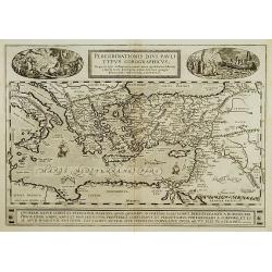
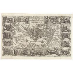
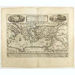
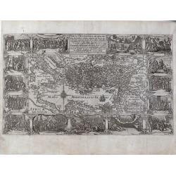
Peregrinationis Divi Pauli Typus?
A splendid map depicting the travels of Paulus. With two fine scenes in top. Showing the countries along the Mediterranean, including Cyprus and Italy. Based on Mercator'...
Place & Date: Antwerp 1595
Selling price: $650
Sold in 2008
Terra Sancta.
This is the most modern of Ortelius' maps of the Holy Land. It focuses specifically on the Holy Land and is oriented with east of the top. Ortelius used as a model the wa...
Place & Date: Antwerp, 1595
Selling price: $600
Sold in 2022
![[Von der Landtschafft Iudaea]](/uploads/cache/90956-250x250.jpg)
[Von der Landtschafft Iudaea]
16th century woodcut view of Jerusalem on the full folio sheet. From "Theatrum Urbium" by Abraham Saur printed in Frankfurt 1595 by N. Basseus.
Place & Date: Frankfurt, 1595
Selling price: $200
Sold in 2010
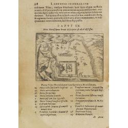
Reisen der Kinder Israel aus Egypten.
A woodblock map which illustrates the route followed by the Israelites in the Exodus from Egypt to the Promised Land. The map is very decorative and shows the Pharaoh dro...
Place & Date: Magdeburg, 1595
Selling price: $300
Sold in 2014
Beschreibung des Heiligen Landes.
Heinrich Bünting map of the Holy Land from the Itinerarum Saccrae Scripturae, which was first published in 1581. It shows Palestineon both sides of the Jordan and the tw...
Place & Date: Magdeburg, 1595
Selling price: $200
Sold in 2014
Peregrinationis Divi Pauli Typus Chorographicus
Map of St. Pauls travels as described by St. Luke, by Abraham Ortelius. Cartography is after Gerard Mercator 1554 map of Europe and other maps of the region. Two vignette...
Place & Date: Antwerp, 1595
Palaestina, Vel Terra Sancta.
Map of the Holy Land with two large strapwork cartouches. The map comes from a scarce pirate edition published by Petrus Keschedt in Cologne one year after the publicatio...
Place & Date: Cologne 1597
Selling price: $150
Sold
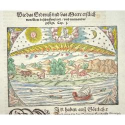
Das erste buch der cosmography
This interesting woodcut illustrates the creation as described in Genesis. It is printed on a full sheet of German text featuring a large decorative initial
Place & Date: Basle 1598
Selling price: $160
Sold
Soria et Terra Santa nuova tavola.
Early map of this classical map of the Holy Land, including Cyprus, prepared by Giovanni Botero. The copper plate was however later used by Giuseppe Rosaccio's expended e...
Place & Date: Venice, 1598
Selling price: $200
Sold in 2014
Peregrinationis Divi Pauli Typus..
A splendid map depicting the travels of Paulus. With two fine scenes in top. Showing the countries along the Mediterranean, including Cyprus and Italy. A first edition wi...
Place & Date: Antwerp, 1598
Selling price: $400
Sold in 2022
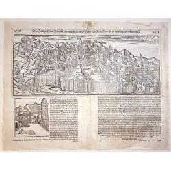
Jerusalem.
A beautiful double page woodcut bird's eye view of Jerusalem from Sebastian Münster's famous "Cosmographia", from the rare 1600 German edition. The view shows ...
Place & Date: Basle, 1600
Selling price: $300
Sold in 2017
Terra sancta a Petro Laicstain perlustrata?
The Holy Land described by Petrus Laicstain and designed by Christian Schrot. Oriented to the east. Shows the shore line from Birut to Gaza. The shore line is distorted b...
Place & Date: Antwerp 1603
Selling price: $450
Sold
Waerachtige beschryvinge vande wydvermaerde Conincklicke Hooft Stadt Jerusalem.
Engraved by Baptista van Doetechum for a bible printed by Jan Everts Cloppenburg. The bible maps of 1590 are the earliest of Plancius compilations to survive.Very rare pl...
Place & Date: Amsterdam, 1604
Selling price: $1000
Sold in 2021
Waerachtige beschryvinge van de.. Stadt Jerusalem; . . .
A highly decorative map of Jerusalem, oriented to the West. Before Plancius, it was common to include a number of Bible maps, however, Plancius was the first to include a...
Place & Date: Amsterdam, 1604
Selling price: $1550
Sold in 2021
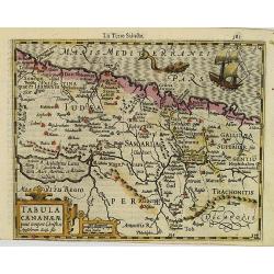
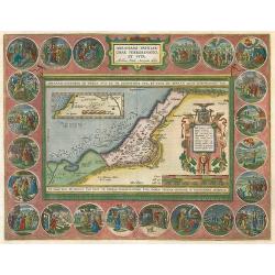
Tabula Geographica in qua Regiones Cananaeae, et Locorum Situs Prout ea Tempore Christi. . .
A superb and highly decorative map from a Dutch Bible depicting the land of Canaan with political divisions during the time of Christ. Fifteen wonderfully etched vignette...
Place & Date: Amsterdam, 1604
Selling price: $600
Sold in 2021
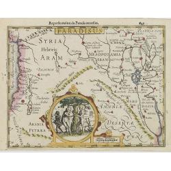
Tabula Geographica, in Qua Paradisus, nec Non Regiones, Urbes oppida, et loca describuntur; quorum in Genesi mentio fit.
A wonderful work of art, consisting of a map of the Holy Land and contiguous regions, including Cyprus and Armenia, surrounded by beautiful etchings. In the center of the...
Place & Date: Amsterdam, 1604
Selling price: $1350
Sold in 2021
Tabula Geographica, in Qua Iisraelitarum, ab Aegypto ad Kenahanaeam usque profectiones omnes, et stationes describuntur...
A highly decorative map illustrating the region surrounding the Dead Sea through the Nile Delta and depicting, the wanderings of the Children of Israel. Top right : indic...
Place & Date: Amsterdam, 1604
Selling price: $1550
Sold in 2021
Tabula Geographica, in qua Omnes Regiones, Urbes, Oppida, Loca et Fluvii Israeliae Describuntur. . .
A very rare map of Israel oriented to the East, originating from a Dutch Bible. Where most Bible publishers included five or six maps into their Bible, Plancius included ...
Place & Date: Amsterdam, 1604
Selling price: $1350
Sold in 2021
Tabula geographica in qua omnes regiones, urbes, oppida, et loca describuntur, ....
A work of art this map, depicting the Southern and Eastern Mediterranean countries visited by the Apostles. It is the final map of the standard set of five Holy Land maps...
Place & Date: Amsterdam, 1604
Selling price: $800
Sold in 2021
The Description of the Holy Land.
Two woodcut biblical maps from the famous "Breeches Bible", one titled "The Description of the Holy Land, containing the places mentioned by the four evang...
Place & Date: London, 1606
Selling price: $195
Sold in 2013
Palaestina.
A decorative miniature map of the Holy Land, stretching from Egypt to Damascus in Syria, published by Petrus Bertius in Amsterdam, at the beginning of the seventeenth cen...
Place & Date: Amsterdam, 1606
Selling price: $150
Sold in 2019
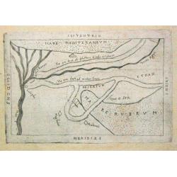
Paradisus.
Early map showing the Syrian desert, Lebanon, and the mouth of the Tigris in the Persian Gulf. Including Babylon, Tripoli, etc.Showing the site of Paradise between the fo...
Place & Date: Amsterdam, 1608
Selling price: $250
Sold in 2008
Tabula Cananae ae prout tempore Christi et Apostolorum divisa fuit.
Early map of the Holy Land, from the first French-text edition of Jodocus Hondius' Atlas Minor.Shortly after the publication of the big folio-atlases, the need was appare...
Place & Date: Amsterdam, 1608
Selling price: $250
Sold in 2010
Peregrinatio Israelitaru In Deserto.
A nice small map depicting the Exodus and the wandering of the Children of Israel. Inset of the encampment enclosed in a strapwork border.From the first French-text editi...
Place & Date: Amsterdam, 1608
Selling price: $100
Sold in 2017
Paradisus.
Attractive map showing the Syrian desert, Lebanon, and the mouth of the Tigris in the Persian Gulf. Including Babylon, Tripoli, etc.Showing the site of Paradise between t...
Place & Date: Amsterdam, 1608
Selling price: $220
Sold in 2012
Iterra Sancta.
Miniature map of Israel and a part of Egypt, with major cities named. The sea is stipple engraved. Strapwork title cartouche at right. Latin text on verso.
Place & Date: Antwerp, 1609
Selling price: $140
Sold
Terrae Chanaan Inter XII Tribuus Israel Distributae Orthographia.
The land Canaan distributed among the 12 Tribes. A map from Augustino Torniello's ' Anales Sacri et Profani.' Rare. Ref.: Laor, Holy Land, entry Anonymus 913.
Place & Date: Frankfurt, Jacobus Fischerus, 1609
Selling price: $800
Sold
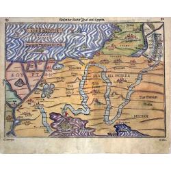
Sinai Desert (no title).
A small map illustrating the crossing of the Red Sea by the Children Israels.
Place & Date: Frankfurt, Jacobus Fischerus, 1609
Selling price: $120
Sold
Hierosolymae, Cura Neemiaeducis Instauratae Descriptio.
Two plans of Jerusalem, left according to Brocardus, right after Villalpando. Geographically there is no difference between the two plans, however, the plan after Brocard...
Place & Date: Frankfurt, Jacobus Fischerus, 1609
Selling price: $250
Sold
Tabula XXXXII Mansinum Populi Israelitici in Deserto.
The perigrinations of the Children Israel. A map from Augustino Torniello\'s \' Anales Sacri et Profani\'. Rare.
Place & Date: Frankfurt, Jacobus Fischerus, 1609
Selling price: $900
Sold
Terrae Chanaan Inter XII Tribuus Israel Distributae Orthographia.
The land Canaan distributed among the 12 Tribes. A rare and elegantly simple Holy Land map from Torniello's Annales Sacri & Profani, featuring only the 12 tribal divi...
Place & Date: Frankfurt, Jacobus Fischeru, 1609
Selling price: $250
Sold in 2021
Palestinae sive totius Terrae Promissionis.
Map of Holy Land from the rare Spanish edition of Abraham Ortelius' "Theatrum Orbis Terrarum", published by Vrientius.Abraham Ortelius(1527-1598), Dutch cartogr...
Place & Date: Antwerp, Robert Bruneau, 1609
Selling price: $675
Sold in 2021
![Terrae Chanaan Inter XII Tribuus Israel Distributae Orthographia. [Lot of 2 maps of Israel]](/uploads/cache/20410-250x250.jpg)
Terrae Chanaan Inter XII Tribuus Israel Distributae Orthographia. [Lot of 2 maps of Israel]
The land Canaan distrubited among the 12 Tribes. A map from Augustino Torniello's ' Anales Sacri et Profani'. Rare. Lot of 2 maps of Israel
Place & Date: c. 1610
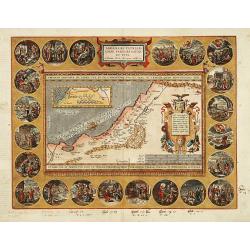
Abrahami Patriarchae Peregrinatio et Vita.
"The Holy Land map itself occupies the centre and is surrounded by vignettes of the life of the Patriarch Abraham. Extremely decorative map made by Ortelius, based o...
Place & Date: Antwerp 1612
Selling price: $2800
Sold
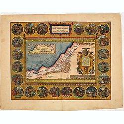
Abrahami Patriarchae Peregrinatio et Vita.
The Holy Land map itself occupies the centre and is surrounded by vignettes of the life of the Patriarch Abraham. Extremely decorative map made by Ortelius, based on Ptol...
Place & Date: Antwerp 1601-1612
Selling price: $1625
Sold
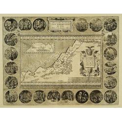
Typus chorographicus, celebrium locoum in regno Judae et..
Drawn by Tilemannus Stella Sigenensi, this map delineates the most important places in the kingdom of Judah and Israel. The shorelines run from Berytus (Beirut) to Rhinoc...
Place & Date: Antwerp 1601-1612
Selling price: $435
Sold
Abrahami Patriarchae Peregrinatio et Vita.
The Holy Land map itself occupies the center and is surrounded by vignettes of the life of the Patriarch Abraham. Extremely decorative map made by Ortelius, based on Ptol...
Place & Date: Antwerp, 1601-1612
Selling price: $1850
Sold in 2014
TERRA SANCTA quae in Sacris Terra Promissionis ol. PALESTINA.
A fine map showing the area of present day Israel and Palestine. Numerous placenames are depicted on the map. East is at the top of the map. A sailing ship and a large...
Place & Date: Amsterdam, (1606) 1613
Selling price: $325
Sold in 2011
Theatrum Terrae Sanctae.
Very important description of the Holy Land, including important maps. Christianus Crucius Adrichomius worked thirty years long on his most important work. It is in three...
Place & Date: Delft, 1613
Selling price: $1950
Sold in 2019
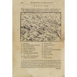
Varia antiquitates in itinere Bethleëmitico confpecta. . .
Text page with copper engraved illustration of region north of Jerusalem taken from Itinerarium Hierosolymitanum et Syriacum, in quo variarum Gentium Mores et Institua in...
Place & Date: Antwerp, Verdussen, 1619
Selling price: $30
Sold in 2009
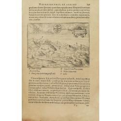
Hiervsalem.
Text page with copper engraved illustration of Jerusalem, with in background Mount Olive, taken from Itinerarium Hierosolymitanum et Syriacum, in quo variarum Gentium Mor...
Place & Date: Antwerp, Verdussen, 1619
Selling price: $30
Sold in 2009
![Hiervsalem. [Jerusalem]](/uploads/cache/25500-250x250.jpg)
Hiervsalem. [Jerusalem]
Text page with copper engraved illustration of Jerusalem, taken from Itinerarium Hierosolymitanum et Syriacum, in quo variarum Gentium Mores et Institua insularum, region...
Place & Date: Antwerp, Verdussen, 1619
Selling price: $50
Sold in 2008
Hiervsalem.
Text page with copper engraved plan of Jerusalem, taken from Itinerarium Hierosolymitanum et Syriacum, in quo variarum Gentium Mores et Institua insularum, regionum, vrbi...
Place & Date: Antwerp, Verdussen, 1619
Selling price: $50
Sold in 2008
![Ramma. [Ramla] / Domus Boni Latronis [Latrum]](/uploads/cache/25502-250x250.jpg)
Ramma. [Ramla] / Domus Boni Latronis [Latrum]
Text page with copper engraved view of Ramla, taken from Itinerarium Hierosolymitanum et Syriacum, in quo variarum Gentium Mores et Institua insularum, regionum, vrbium s...
Place & Date: Antwerp, Verdussen, 1619
Selling price: $30
Sold in 2009
TERRA SANCTA quae in Sacris Terra Promissionis ol: PALESTINA.
Beautiful map of the Holy Land by Hondius.
Place & Date: Amsterdam, 1619
Selling price: $500
Sold in 2014
Terra Sancta quae in Sacris Terra Promissionis ol: Palestina.
An early, large, very decorative east oriented map of Palestine depicting both sides of the river Jordan, with the shore line running from Berithus (Beirut) to Gaza. It i...
Place & Date: Amsterdam, 1619
Selling price: $375
Sold in 2021
Terra Sancta quae in Sacris Terra Promissionis ol. Palestina.
A map of Palestine on both sides of the Jordan, the shore line running from Berithus (Beirut) to Gaza. Orientated towards the east on top. Largely based on Ortelius 1584 ...
Place & Date: Amsterdam, 1620
Selling price: $220
Sold in 2019
.. Lumen Historiarum Per Orientem .. Concinn. Fran. Hareio ..'
Shows the pyramids in Egypt, the route of Abraham from Ur to Sichem, and the wandering of the Children of Israel.Inset top a fine world map according to Ortelius. (Typus ...
Place & Date: Antwerp, 1624
Selling price: $425
Sold
Abrahami Patriarchae Peregrinatio, et Vita.
The most beautiful "carte à figures" map from Ortelius' Theatri Orbis Terrarum Parergon. The medallions illustrate the life of Abraham. Latin text on verso.
Place & Date: Antwerp, 1624
Selling price: $2900
Sold in 2009
![Salomonis templi Vestigium. [Salomon's temple]](/uploads/cache/26450-250x250.jpg)
Salomonis templi Vestigium. [Salomon's temple]
Plan of Salomon's Temple. From an uncommon edition of Kerckelycke Historie van Neder-Landt which was a Dutch text edition of Agostino Torniello's Annales Sacri et Profani...
Place & Date: Holland, ca. 1625
Selling price: $50
Sold in 2009