Browse Listings in Asia
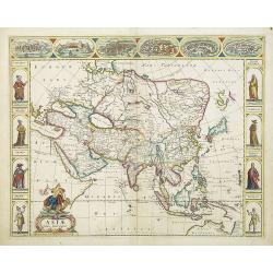
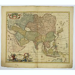
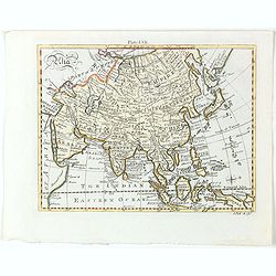
Asiae Nova Descriptio.
A fine "carte à figures"- map of Asia with in the margins views of Ormus, Aden, Jerusalem, Damascus, Rhodos, Famagusta and costumed figures of Asian people in ...
Date: Amsterdam, 1680
Selling price: ????
Please login to see price!
Sold in 2016
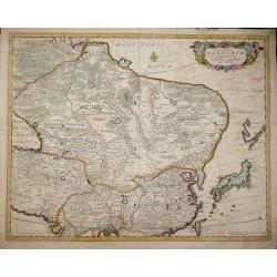
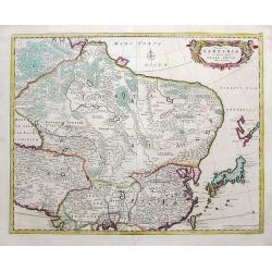
Tabula Tartariae et majoris partis Regni Chinae . .
Strapwork title cartouche with two putti and a compass rose embellish the map. De Wit's map of NE Asia, extending from the Island of Formosa, the Gandgers and the eastern...
Date: Amsterdam, 1680
Selling price: ????
Please login to see price!
Sold in 2014
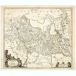
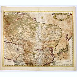
Suchuen et Xensi, Provinciae seu Praefecturae Regni Sinensis. . .
Map of the central China provinces of Sichuan and Shaanxi with two cartouches. North orientated to the right.
Date: Amsterdam, c. 1680
Selling price: ????
Please login to see price!
Sold in 2014
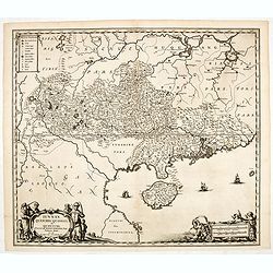
Iunnan, Queicheu, Quangsi, et Quantung. . .
A beautifully engraved map of Southern China covering Hainan and the Pearl River Delta with Macao and the islands around present-day Hong Kong.
Date: Amsterdam, c. 1680
Selling price: ????
Please login to see price!
Sold in 2014
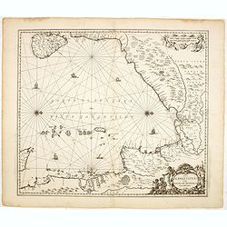
Sinus Gangeticus vulgo Golfo de Bengala Nova descriptio.
Showing the east coast of India and Sri Lanka. West to the top.
Date: Amsterdam, 1680
Selling price: ????
Please login to see price!
Sold in 2014
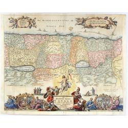
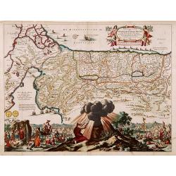
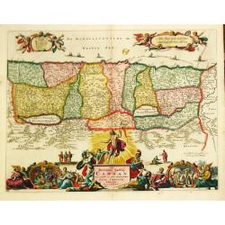
Het Beloofde Landt Canaan, Door Wandelt Onfen Salichmaecker Jesu Christo Neffens Fyne Apostelen.
Detailed map of the Holy Land, showing the travels of Christ and the Apostles, including Paul's travel's at sea and numerous sailing vessels. This map is derived from Ni...
Date: Rotterdam, 1680
Selling price: ????
Please login to see price!
Sold in 2019
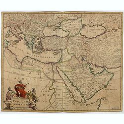
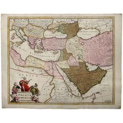
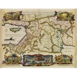
Turcicum Imperium.
Detailed map of the Turkish Empire by Holland's leading mapmaker at the end of the seventeenth century. The cartouche shows an Ottoman administrator or possibly the Sulta...
Date: Amsterdam, 1680
Selling price: ????
Please login to see price!
Sold in 2016
Kingdoms of Tartaria.
Titled Tartary in the cartouche ‘A General Mapp of the Kingdoms of Tartaria. Designed by Monsieur Sanson’ engraved by Thomas Burnford, after the map by Nicolas Sanson...
Date: London, 1680
Selling price: ????
Please login to see price!
Sold in 2018
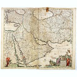
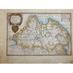
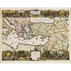
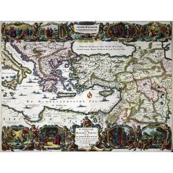
Nova Persiae Armeniae Natoliae et Arabiae.
East from Cyprus to Iran with numerous place names and ornamental cartouches below. There are vignettes of sailing ships in sea areas and the land divisions of the time a...
Date: Amsterdam, 1680
Selling price: ????
Please login to see price!
Sold in 2016
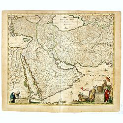
Nova Persiae Armeniae Natoliae et Arabiae.
East from Cyprus to Iran with numerous place names and ornamental cartouches below. There are vignettes of sailing ships in sea areas and the land divisions of the time a...
Date: Amsterdam, 1680
Selling price: ????
Please login to see price!
Sold in 2016
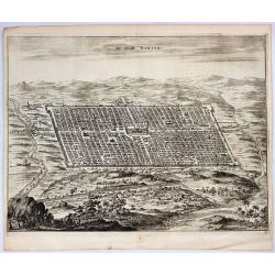
De Stadt Ninive.
A striking copper engraving providing a bird’s-eye view of the city and surrounding countryside of Ninive in Iraq. It is from Olfert Dapper's "De Stadt Ninive"...
Date: Amsterdam, 1680
Selling price: ????
Please login to see price!
Sold in 2019
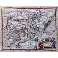
Tabula Tartariae et majoris partis regni Chinae.
Stretching from the Caspian Sea in the west to Formosa in the south-east. Including the peninsula of Korea, Japan, Taiwan and the east coast of Yedso. Decorated with fine...
Date: Amsterdam, 1680
Selling price: ????
Please login to see price!
Sold in 2018
Asiae Nova Delineatio.
A superb map of the whole of Asia and the East Indies. The discoveries of Tasman, Janszoon and Cartensz are reflected in Australia and New Guinea.The delineation of Japan...
Date: Amsterdam, 1680
Selling price: ????
Please login to see price!
Sold in 2018
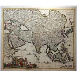
Accuratissima Totius Asiae Tabula. . .
A fine example of De Wit's map of Asia, featuring ornate cartouche with eight traders, two parrots, a camel and a monkey, together with five sailing ships, a compass rose...
Date: Amsterdam, ca. 1680
Selling price: ????
Please login to see price!
Sold in 2018
Route d' Osacca à Iedo / Route de Nangasacqui a Osacca.
A rare folio-sized copper engraving of Japan with the route from Osaka to Jedo (Tokyo) and the route from Nagasaki to Osaka. On the top map the details of the route from ...
Date: Amsterdam, 1680
Selling price: ????
Please login to see price!
Sold in 2021
TURCICUM IMPERIUM.
A detailed map of the Turkish Empire by Holland's leading mapmaker at the end of the seventeenth century. The cartouche shows an Ottoman administrator ,or possibly the S...
Date: Amsterdam, 1680
Selling price: ????
Please login to see price!
Sold in 2019
Tabula Tartariae et majoris partis Regnis Chinae.
A very decorative early map extending from the Caspian Sea until Japan, including China and Formosa. With a curious shape of eastern Russia without Kamchatka. Yedso is sh...
Date: Amsterdam, ca 1680
Selling price: ????
Please login to see price!
Sold in 2019
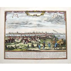
Constantinopolis.
An extremely rare panoramic town-view of Constantinople in Turkey, published by Frederick de Wit. In stunning colors and condition! Text in Latin, French, German, and Eng...
Date: Amsterdam, ca 1680
Selling price: ????
Please login to see price!
Sold in 2020
![Le Palais Imperial de Iedo [Imperial Palace Tokio]](/uploads/cache/84795-250x250.jpg)
Le Palais Imperial de Iedo [Imperial Palace Tokio]
Very decorative view of the Imperial Palace at Tokio. From : Montanus A., Ambassades Mémorables De La Compagnie Des Indes Orientales Des Provinces Unies Vers Les Empereu...
Date: Amsterdam, 1680
Selling price: ????
Please login to see price!
Sold in 2020
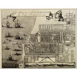
Plan de la Ville…de Batavia / Ware afbeeldinge wegens het Casteel ende Stadt Batavia gelegen opt groot Eylant Java
Very interesting map of Batavia (modern-day Jakarta) as key base in Asia for the Dutch East-Indies Company (VOC). The map shows the city and the surrounding area and is ...
Date: 1680
Selling price: ????
Please login to see price!
Sold in 2021
![[Lot of 3 maps] Tabula Tartariae et Regni China.](/uploads/cache/100353-(2)-250x250.jpg)
[Lot of 3 maps] Tabula Tartariae et Regni China.
Frederick de Wit (1610-1698) became after the closing of the Blaeu firm one of the most important Amsterdam-based publishers. He published several atlases, Atlas Minor (1...
Date: c. 1680
Selling price: ????
Please login to see price!
Sold in 2022
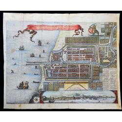
Waere affbeeldinge wegens het casteel ende stadt Batavia.
A good impression of this finely engraved and detailed plan of Batavia, present-day Jakarta, the Dutch V.O.C. center of trading activities in the East Indies. Copied afte...
Date: Amsterdam, 1681
Selling price: ????
Please login to see price!
Sold in 2011

Daniel Taverniers Land Charte des KönigreichsTUNQUIN.
Covers northern parts Vietnam. From a German edition of Travernier's travel book. According to Cox: Travernier ... Wil always continue among the most valuable travellers ...
Date: Nuremberg 1681
Selling price: ????
Please login to see price!
Sold
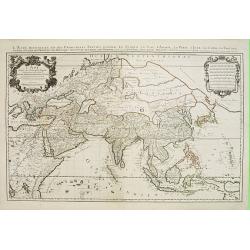
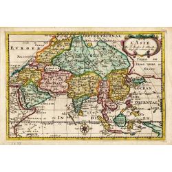
L'Asie divisee en ses principales regions et ou se peuvent voir ..
One of the largest and most impressive general atlas maps of the Asian continent. Based on Nicolas Sanson's Sr's map of 1650, but Jaillot has updated the north-eastern co...
Date: Paris, 1681
Selling price: ????
Please login to see price!
Sold
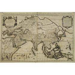
L'Asie divisee en ses principales regions et ou se peuvent voir ..
From the first edition of the Amsterdam pirate edition. One of the largest and most impressive general atlas maps of the Asian continent. Based on Nicolas Sanson's Sr's m...
Date: Amsterdam, 1681
Selling price: ????
Please login to see price!
Sold
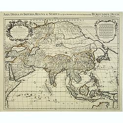
L'Asie divisée en ses principales regions et ou se peuvent voir. . .
One of the largest and most impressive general atlas maps of the Asian continent. Based on Nicolas Sanson's Sr's map of 1650, but Jaillot has updated the north-eastern co...
Date: Paris, 1681
Selling price: ????
Please login to see price!
Sold in 2012
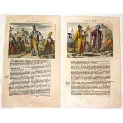
(2 Engravings) Syrien.
Two hand-colored engravings featuring the 17th century fashions of Syrian men. From Dapper's book "Asia, Oder Genaue und Grundliche Beschreibung de Gantzen Syrien un...
Date: Amsterdam, 1681
Selling price: ????
Please login to see price!
Sold in 2016
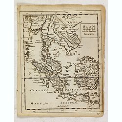
Siam, Malacca and the Indian Islands.
Uncommon map of Siam, Malacca and the Indian Islands, printed by A. Godbid and J. Playford, for R. Scott. Included in "New systeme of the mathematicks: containing . ...
Date: London, 1681
Selling price: ????
Please login to see price!
Sold in 2019
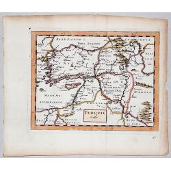
TURQUIE in Asia.
A very rare copperplate map of Asian Turkey from Sir Jonas Moore's "New System of Mathematics" published in London, printed by A. Godbid and J. Playford, for Ro...
Date: London, 1681
Selling price: ????
Please login to see price!
Sold in 2017
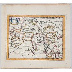
ASIA.
A copperplate map of Asia from Sir Jonas Moore's "New System of Mathematics"published in London and printed by A. Godbid and J. Playford, for Robert Scott in 16...
Date: London, 1681
Selling price: ????
Please login to see price!
Sold in 2017
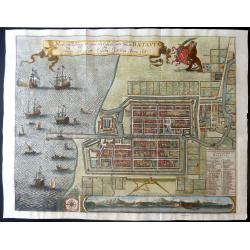
Waere affbeeldinge wegens het casteel ende stadt Batavia.
A large, detailed and finely engraved plan of Batavia, present-day Jakarta, the Dutch center of trading activities in the East Indies. Magnificently engraved by Matheus d...
Date: Amsterdam, 1681
Selling price: ????
Please login to see price!
Sold in 2019
Asia.
Detailed map the Asian continent. The map is of interest for the use of Sea of Corea, the sea between Korea and Japan.
Date: Amsterdam, 1682
Selling price: ????
Please login to see price!
Sold in 2023
Perigrinatie ofte Veertich-Jarige Reyse..
The map is lavishly colored using gold for the title and further embellishment. The figures and decorations are painted in a somewhat impressionistic way. Varnish is used...
Date: Amsterdam, 1682
Selling price: ????
Please login to see price!
Sold in 2011

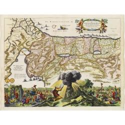
De Gelegentheyt van t' Paradys en t' Landt Canaan, mitsgaders d' eerst bewoonde Landen der Patriarchen.
Dutch so-called "Staten" bibles, published between 1637 and c. 1760, contained 5 maps: The World, "Paradise", The Perigrinations, The Promised Land Ca...
Date: Amsterdam, H. Keur en M. Doornick, ca.1682
Selling price: ????
Please login to see price!
Sold
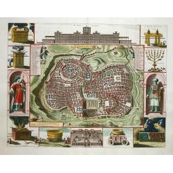
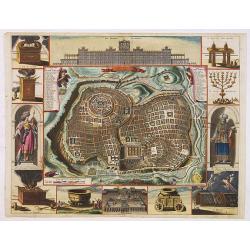
Jerusalem.
Great bird's eye plan of the holy city flanked by engravings of religious icons, and two priests. At the top is a large elevation of the Temple of Solomon and at bottom i...
Date: Amsterdam 1682
Selling price: ????
Please login to see price!
Sold
De Gelegentheyt van t' Paradys en t' Landt Canaan, mitsgaders d' eerst bewoonde Landen der Patriarchen.
Dutch so-called ' Staten' bibles, published between 1637 and c. 1760, contained 5 maps: The World, ' Paradise', The Perigrinations, The Promised Land Canaan, The Travels ...
Date: Amsterdam, H. Keur en M. Doornick, 1682
Selling price: ????
Please login to see price!
Sold in 2020
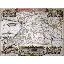
De gelegentheyt van 't Paradys en de 't Landt Canaan..
A finely engraved map of the Middle East from the Mediterranean, including Cyprus, eastwards to Syria and Iraq.At the four corners are insets showing the temptation of Ev...
Date: Amsterdam 1682
Selling price: ????
Please login to see price!
Sold
Perigrinatie ofte Veertich-Jarige Reyse..
An attractive map of present-day Israel, also parts of Jordan and Egypt, illustrating the exodus of the Children of Israel crossing the Red Sea.Three dramatic episodes ar...
Date: Amsterdam 1682
Selling price: ????
Please login to see price!
Sold
De Beschrijvingh van de Reysen Pauli..
Decorative map with 8 insets depicting the wanders of Paulus and the Apostles. Dutch text on verso. Covers the territory from Sicily in the Mediterranean Sea to the Persi...
Date: Amsterdam 1682
Selling price: ????
Please login to see price!
Sold
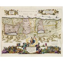
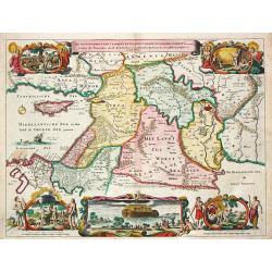
Het Beloofde Landt Canaan..
Decorative map of the Holy Land depicting the twelve tribes of Israel.Elaborate, engraving along the bottom of the map depicts the Apostles, a Nativity scene, the Crucifi...
Date: Amsterdam 1682
Selling price: ????
Please login to see price!
Sold
Het Beloofde Landt Canaan door wandelt van onsen Salichmaecker Iesu Christo, neffens syne Apostelen.
Dutch so-called "Staten bibles", published between 1637 and c. 1760, contained 5 maps: The World, "aradise", The Perigrinations, The Promised Land Can...
Date: Amsterdam, 1682
Selling price: ????
Please login to see price!
Sold in 2010
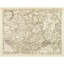
T\'Ryk van den Grooten Mogol.
An attractive map of northern India, and inner Asia, published by F.Halma.
Date: Utrecht, 1682
Selling price: ????
Please login to see price!
Sold in 2010
Jerusalem
Plan of ancient Jerusalem from a Dutch bible. At the top the Temple as a Renaissance palace, at left and right Biblical figures and Temple vessels.
Date: Amsterdam, 1682
Selling price: ????
Please login to see price!
Sold
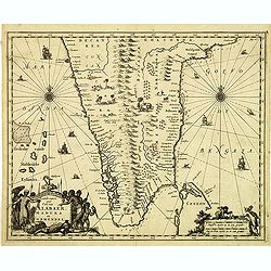
Landt caert vande Malabaer, Madura en Cormendel.
Detailed map of the southern tip of India and a part of Sri Lanka from Joan Nieuhof, "Gedenkwaerdige zee- en lantreize. . ."Decorative cartouches in the lower l...
Date: Amsterdam, 1682
Selling price: ????
Please login to see price!
Sold in 2012
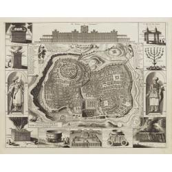
Jerusalem.
Engraved by Bastiaan Stoopendaal from Juan Bautista Villapando's imaginary "carte à figures"- plan of Jerusalem. This bird's-eye view is surrounded by 12 scene...
Date: Amsterdam, 1682
Selling price: ????
Please login to see price!
Sold in 2020
De beschryvingh van de reysen Pauli ..
Nice decorative map with eight vignettes with episodes from the travels of St. Paul, including 64 numbered references on the map.
Date: Amsterdam, 1682
Selling price: ????
Please login to see price!
Sold in 2020
De gelegentheyt van 't Paradys en 't Landt Canaan mitsgaders d'eerst bewoonde Landen de Patriarchen.
Shows the Middle East from Assyria to the Mediterranean Sea. Shows also the route taken by Abraham from Ur to Haran. Vignettes show Adam in Paradise with various animals,...
Date: Amsterdam, 1682
Selling price: ????
Please login to see price!
Sold in 2020
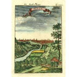
Miaco.
A late 17th century miniature view of the skyline of Miaco (Kyoto), by Allain Manneson Mallet (1630-1706), a well travelled military engineer and geographer who worked in...
Date: Paris 1683
Selling price: ????
Please login to see price!
Sold
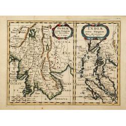
Indiae extra Gangem pars Septentrio../ ..pars Meridionalis..
Showing to the left Burma, Thailand, Cambodia etc. The map to the right shows the Malaysian peninsula, Singapore and northern Sumatra.
Date: Utrecht 1683
Selling price: ????
Please login to see price!
Sold
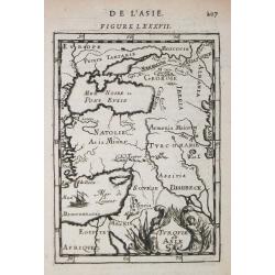
Turque en Asie.
Alain Manneson Mallet (1603-1706) published in 1683 his ' Description de l' Univers' in 5 volumes. In 1686 a German edition appeared.A map from Alain Manesson Mallet's 'D...
Date: Paris, 1683
Selling price: ????
Please login to see price!
Sold
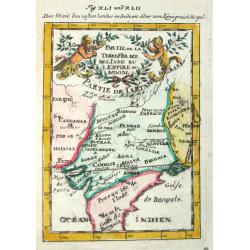
Partie de la Tere Ferme de l'Inde ou l'Empire du Mogol.
Alain Manneson Mallet (1603-1706) published in 1683 his ' Description de l' Univers' in 5 volumes. In 1686 a German edition appeared.
Date: Paris, 1683
Selling price: ????
Please login to see price!
Sold
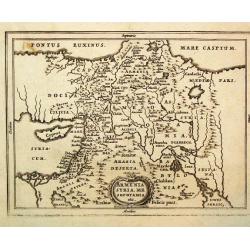
Armenia, Syria, Mesopotamia etc.
Philippe Cluverius (1580-1622), geographer of Danzig, settled in Leiden (Holland) specialized in Near Easrt and Ancient Geography. His main works ' Geographicus Academicu...
Date: Amsterdam, 1683
Selling price: ????
Please login to see price!
Sold
L\' Asie.
Nicolas Sanson (1600-67), ' father of the French cartography' and founder of the Sanson firm. Atlas ' Cartes générales de toutes les parties du Monde', 1658-70 and a po...
Date: Amsterdam, 1683
Selling price: ????
Please login to see price!
Sold in 2017
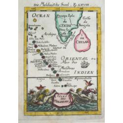
Isles de Maldives
Alain Manneson Mallet (1603-1706) published in 1683 his ' Description de l' Univers' in 5 volumes. In 1686 a German edition appeared.
Date: Paris, 1683
Selling price: ????
Please login to see price!
Sold
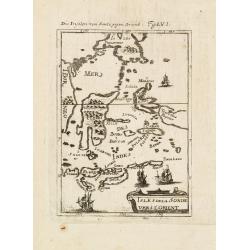
Isles dela Sonde vers l'Orient.
A late 17th century miniature map of the Moluccas and southern part of the Philippines, by Allain Manneson Mallet (1630-1706), a well traveled military engineer and geogr...
Date: Paris, 1683
Selling price: ????
Please login to see price!
Sold in 2013
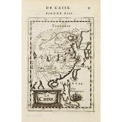
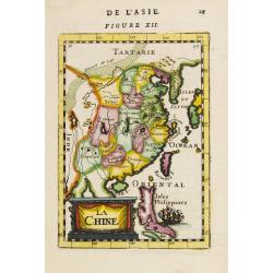
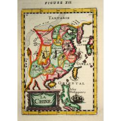
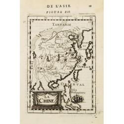
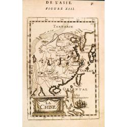
La Chine
A charming small map of China, Taiwan, Philippines, Korea and Kyushu (Japan).From the French text edition of "Description d'Univers.." By Allain Manneson Mallet...
Date: Paris 1683
Selling price: ????
Please login to see price!
Sold
La Chine
A charming small map of China, Taiwan (Formosa I.), Philippines, Korea and Kyushu (Japan). By Allain Manneson Mallet (1630-1706), a well traveled military engineer and ge...
Date: Paris, 1683
Selling price: ????
Please login to see price!
Sold
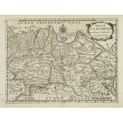
Groot Tartaryen.
Engraved by A.Winter. In lower right hand corner Korea depicted as an island.
Date: Utrecht, 1683
Selling price: ????
Please login to see price!
Sold
La Chine.
Alain Manneson Mallet (1603-1706) published in 1683 his ' Description de l' Univers' in 5 volumes. In 1686 a German edition appeared.An attractive little map of China.
Date: Paris, 1683
Selling price: ????
Please login to see price!
Sold
La Chine.
A charming small map of China, Taiwan, Philippines, Korea and Kyushu (Japan).From the French text edition of "Description d'Univers.." (5 volumes), 1683. By All...
Date: Paris, 1683
Selling price: ????
Please login to see price!
Sold
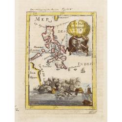
![Isole dell 'India cioè le Molucche le Filippine e della Sonda . . . [East Indies].](/uploads/cache/26611-250x250.jpg)
Isole dell 'India cioè le Molucche le Filippine e della Sonda . . . [East Indies].
In lower left hand corner a large title cartouche, decorated with mermaids, mermen and playful putti. A scarce, uncommon, late 17th century map of South East Asia, based ...
Date: Rome, 1683
Selling price: ????
Please login to see price!
Sold in 2008
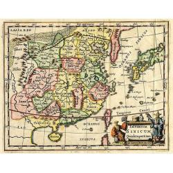
Imperium Sinicum Quindecupartitum.
This rare map is a reduced version of Kircher's map of China, printed in 1667. The cartouche features a Chinese hunter with a hawk and a seated Chinese lady holding a fan...
Date: 1683
Selling price: ????
Please login to see price!
Sold in 2012
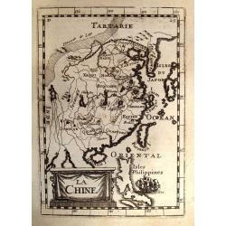
La Chine.
A charming small map of China, Taiwan, the Philippines, Korea, and Kyushu (Japan). From the original French text edition of "Description d'Univers..." b...
Date: Paris, 1683
Selling price: ????
Please login to see price!
Sold in 2009
Imperium Sinicum Quindecupartitum.
This rare map is a reduced version of Kircher's map of China, printed in 1667. The cartouche features a Chinese hunter with a hawk and a seated Chinese lady holding a fan...
Date: 1683
Selling price: ????
Please login to see price!
Sold in 2012
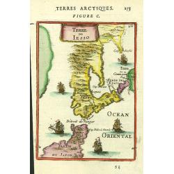
Terre de Iesso.
A charming small map of Hokkaido and the northern part of Honshu, by Allain Manneson Mallet (1630-1706), a well travelled military engineer and geographer who worked in 1...
Date: Paris, 1683
Selling price: ????
Please login to see price!
Sold in 2016
![Isole dell 'India cioè le Molucche le Filippine e della Sonda . . . [East Indies].](/uploads/cache/31192-250x250.jpg)
Isole dell 'India cioè le Molucche le Filippine e della Sonda . . . [East Indies].
In lower left hand corner a large title cartouche, decorated with mermaids, mermen and playful putti. A scarce, uncommon, late 17th century map of South East Asia, based ...
Date: Rome, 1683
Selling price: ????
Please login to see price!
Sold in 2011
La Chine.
A charming small map of China, Taiwan, the Philippines, Korea, and Kyushu (Japan). From the original French text edition of "Description d'Univers..." by Allain...
Date: Paris, 1683
Selling price: ????
Please login to see price!
Sold in 2012
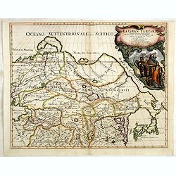
La Gran Tartaria divisa nelle sue parti pricipali da Giacomo
In upper right hand corner a large title cartouche with dedication to Tavernier and Thévenot. The cartographer was Giacomo Cantelli (1643-1695) who was active in Modena ...
Date: Rome, 1683
Selling price: ????
Please login to see price!
Sold in 2014
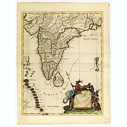
Penisola dell India di là dal Gange. . .
Giacomo Rossi's fine late 17th century map of India and Ceylon. Issued in Il Mercurio geografico In lower right hand corner a large title cartouche.The cartographer was G...
Date: Rome, 1683
Selling price: ????
Please login to see price!
Sold in 2015
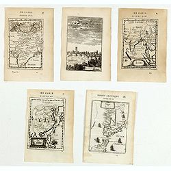
(Five engravings of Asian interest from Description de l\'Univers)
Finely etched prints and maps entitled : Terre de Iesso, La Chine, Inde, Visapor, Partie de la Terre Ferme de L'Inde ou L'Empire du Mogol. From the French text edition of...
Date: Paris, 1683
Selling price: ????
Please login to see price!
Sold in 2015
Habitans des Isles de la Sonde & Molusques (2 Prints)
Two fine engravings of the inhabitants of Indonesia. They are from "Geographie, Ancienne & Moderne."
Date: Paris, 1683
Selling price: ????
Please login to see price!
Sold in 2017
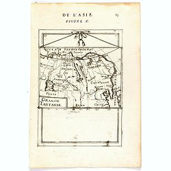
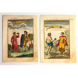
Grande Tartarie (de L'Asie / Figure V).
A fine and uncommon early 17th century map of Tartary with Korea.From the French text edition of "Description d'Univers", 1683. by Allain Manneson Mallet (1630-...
Date: Paris, 1683
Selling price: ????
Please login to see price!
Sold
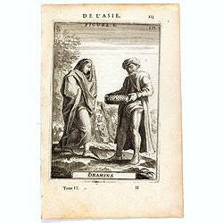
Bramins (de L'Asie / Figure L).
A fine and uncommon early 17th century miniature costume plate showing Brahmins from India.From the French text edition of Description d'Univers, 1683. by Allain Manneson...
Date: Paris, 1683
Selling price: ????
Please login to see price!
Sold in 2016
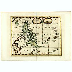
Insulae Philippinae (with inset of the Ladrones).
Fine example of this detailed map the Philippines, including a large inset map of the Ladrones. This is one of the earliest obtainable maps to focus on the Philippine isl...
Date: Utrecht/Amsterdam, J.Halma, 1683
Selling price: ????
Please login to see price!
Sold in 2019
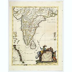
Penisola dell'India di qua dal Gange et Isole intorno ad essa adiacenti. DA GIACOMO CANTELLI DA VIGNOLA.
This is an uncommon map showing the southern part of India, with Sri Lanka and Maldives, from "Mercurio Geografico", published in Rome by G. de Rossi. A very ni...
Date: Italy, 1683
Selling price: ????
Please login to see price!
Sold in 2020
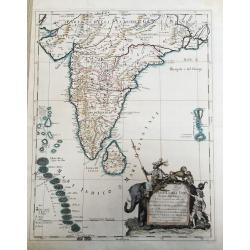
Penisola Dell India di qua dal Gange. . .
A lovely, decorative map of India, Ceylon (Sri Lanka) the Maldive Islands, and surrounds, by Cantelli da Vignola, and published by Rossi in Rome. Plenty of good map detai...
Date: Rome, 1683
Selling price: ????
Please login to see price!
Sold in 2020
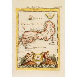
Isles du Japon.
A charming late 17th century French map with a very decorative title cartouche showing trumpet-blowing cherubs.From the German text edition published by Davis Zunners. Je...
Date: Franckfurt 1684
Selling price: ????
Please login to see price!
Sold
Les Isles Philippines 1684.
A charming late 17th century French map of the Philippines with a large pictorial cartouche depicting a mermaid with sea horses, a nautical sailing ship scene across the ...
Date: Franckfurt 1684
Selling price: ????
Please login to see price!
Sold
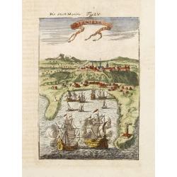
Manille.
A charming late 17th century French bird's-eye view of Manila and its harbour. With a ribbon style title cartouche and a nautical sailing ship scene on the bottom.By Alla...
Date: Franckfurt 1684
Selling price: ????
Please login to see price!
Sold
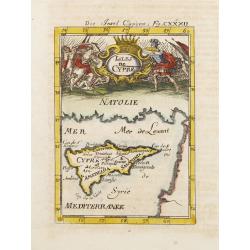
Isles de Cypre.
A charming late 17th century French map of Cyprus with a large pictorial cartouche depicting an infantry combat.By Allain Manneson Mallet (1630-1706), a well traveled mil...
Date: Franckfurt 1684
Selling price: ????
Please login to see price!
Sold