Browse Listings in America > South America > Peru
![[ Peruvian inhabitants ].](/uploads/cache/27276-250x250.jpg)
[ Peruvian inhabitants ].
Aquatint depicting Peruvian inhabitants.Engraved by Gallina.From Giulio Ferrario's work Le Costume Ancien et Moderne ou Histoire du gouvernement, de la milice, de la reli...
Date: Milan, 1827
Selling price: ????
Please login to see price!
Sold in 2009
![[ Manco Capa and Coya Mama Oello ].](/uploads/cache/27275-250x250.jpg)
[ Manco Capa and Coya Mama Oello ].
Aquatint depicting Manco Capa and Coya Mama Oello, the emperor's wife at a village meeting.Manco Capa, the last Incan emperor, was crowned (1534) as a puppet ruler by Fra...
Date: Milan, 1827
Selling price: ????
Please login to see price!
Sold in 2009
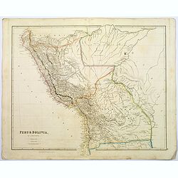
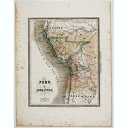
Peru & Bolivia.
A large, detailed steel engraved map of the South American states of Peru & Bolivia. Peru gained its independence from Spain in 1821. Bolivia was named after Simon Bo...
Date: London, 1839
Selling price: ????
Please login to see price!
Sold in 2017
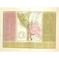
Le Due Repubbliche cioe La Confederazione Peruvian et Bolivia.
A rare, detailed map of Peru and Bolivia. The map is surrounded by explanatory historical text. Tasso's map was prepared by J.A. Buchon and A de la Sage for "L'ATLAN...
Date: Venice, 1840
Selling price: ????
Please login to see price!
Sold in 2017
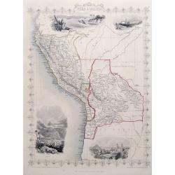
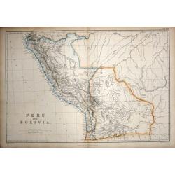
Peru & Bolivia.
A very decorative steel-engraved map extending from Guayaquil southwards until the Atacama. Very detailed with place names, rivers, hills, bays, etc.Attractively illustra...
Date: London, ca. 1850
Selling price: ????
Please login to see price!
Sold in 2018
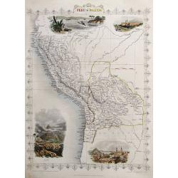
Peru & Bolivia
A very decorative steel-engraved map extending from Guayaquil southwards until the Atacama. Very detailed with place names, rivers, hills, bays, etc.Attractively illustra...
Date: London, ca.1850
Selling price: ????
Please login to see price!
Sold in 2017
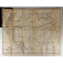
Map of the Valley of the Amazon To Accompany Lt. Herndon's Report.
This is one of three maps that accompanied Herndon's report, “Exploration of the Valley of the Amazon”. In 1851, Lieutenant Herndon was commissioned to lead the first...
Date: Baltimore, 1853
Selling price: ????
Please login to see price!
Sold in 2018
Peru e Bolivia.
Uncommon map of Peru and Bolivia prepared by Francesco Costantino Marmocchi. Above the map "Geografia Commerciale". From "Il Globo Atlante di carte Geograf...
Date: Genova, Paolo Rivara fu Giacomo, 1858
Selling price: ????
Please login to see price!
Sold in 2020
Peru and Bolivia.
Published by Blackie & Son Glasgow Edinburgh & London 1860. This highly detailed map of the area comes from "The Imperial Atlas of Modern Geography". Po...
Date: Glasgow Edinburgh & London, 1860
Selling price: ????
Please login to see price!
Sold in 2015
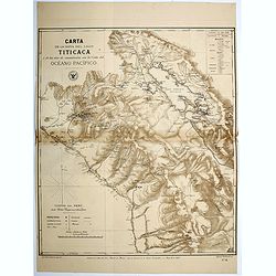
Carta de la Hoya del Lago Titicaca...Oceano Pacifico.
Map of the region surrounding Lake Titicaca in Peru. Map shows roads, railways, major, and minor towns, mineral mines, and the physical geography of the region. Map has a...
Date: Santiago, 1879
Selling price: ????
Please login to see price!
Sold in 2016
