Browse Listings in America > North America > North Pole
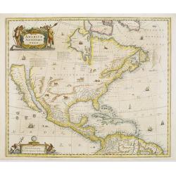
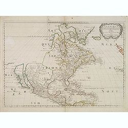
America Septentrionalis.
Showing California as an island, and above, the north west of the continent left blank except for two legends explaining the discoveries to that date. The Hudson Bay is c...
Place & Date: Amsterdam, 1647
Selling price: $2700
Sold in 2008
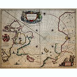
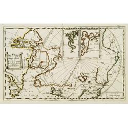
Regiones Sub Polo Arctico.
A fine Blaeu version of the Janssonius map of 1637. It depicts rhumb lines radiating from the North Pole. A large title cartouche, with two figures and numerous wind head...
Place & Date: Amsterdam, 1647
Selling price: $490
Sold in 2017
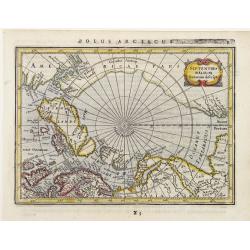
Septentrionalium Terrarum Descript.
Detailed miniature map of the North Pole, from a German text edition of his Atlas Minor. Engraved by Petrus Kaerius.
Place & Date: Amsterdam (1628) 1648
Selling price: $110
Sold
Mexicum in hac forma in lucem edebat IOANNES BAPTISTA NICOLOSIVS S.T.D.
The first state of Nicolosi's rare and important map of south-western North America. Although the Spanish settlements in New Mexico were already more than half a century ...
Place & Date: Rome 1650
Selling price: $6000
Sold
Pais qui dependent de la Norvege suivant les derniers relations.
Rare map of the North Pole. With inset maps of Faeroe and Shetland Islands.
Place & Date: Paris 1650
Selling price: $285
Sold
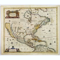
Amerique Septentrionale par N. Sanson.
Decorative and important map of the Americas with a CALIFORNIA AS AN ISLAND. Engraved by Abraham Peyrounim (c.1620 - c.1666).Sanson's map of North America is the first to...
Place & Date: Paris, after 1650
Selling price: $2200
Sold in 2014
America Septentrionalis.
A wonderful map showing California as an island, and above, the north west of the continent left blank except for two paragraphs explaining the discoveries to date. Inter...
Place & Date: Amsterdam, ca 1650
Selling price: $1900
Sold in 2019
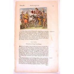
Native Americans Bring Food & Water & Treasure.
Fine Historical hand-colored copperplate engraving featuring Native Americans bringing food and treasure. Arnoldus Montanus (1625–1683) was a Dutch teacher and author....
Place & Date: Amsterdam. 1671
Selling price: $21
Sold in 2013
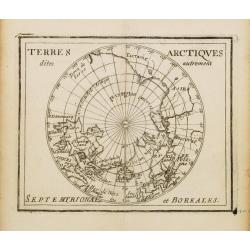
Terres Arctiques.. Septemtrional et Boreales.
Uncommon miniature map of the North Pole, including Iceland, the coast of Russia, Greenland, etc, from Pierre Duval's La Geographie Universeille dated 1676. Following his...
Place & Date: Paris, 1676
Selling price: $300
Sold
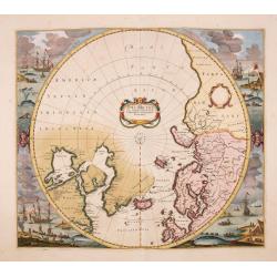
Poli Arctici, et circumiacentium terrarum descriptio novissima. . .
A re-issue of the Hondius' plate, but without the signature. A particularly decorative map of the North Pole. Several Dutch names in Labrador. The toponymy in Canada refl...
Place & Date: Amsterdam, ca.1676
Selling price: $2025
Sold in 2016