Browse Listings in America > North America > North Pole
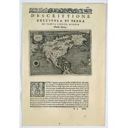
Descrittione dell' isola et terra di Santa Croce, overo Mondo Nuovo.
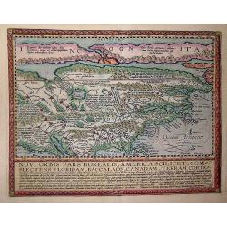
Porcacchi's map of North America, set in a page of text From "L'Isole piu famoso del mondo”. This is the second earliest obtainable map of North America, preceded ...
Place & Date: Venice, 1572-1585
Selling price: $550
Sold in 2019
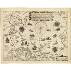
Deliniatio cartae trium navigationum per Batavos..
A major landmark in Arctic cartography incorporating recent voyages including Barents' third voyage to this region, made in 1596-7. A derivative of Willem Barentsz's map ...
Place & Date: Frankfurt 1599
Selling price: $2150
Sold
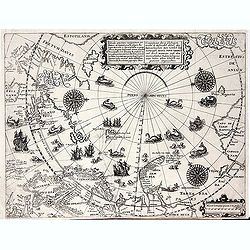
Deliniatio cartae trium navigationum per Batavos. . .
A major landmark in Arctic cartography incorporating recent voyages including Barents' third voyage to this region, made in 1596-7. A derivative of Willem Barentsz's map ...
Place & Date: Frankfurt, 1599
Selling price: $1900
Sold in 2012
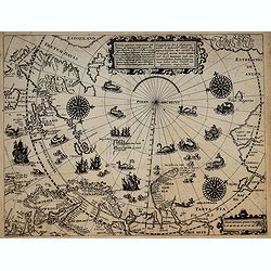
Deliniatio cartae trium navigationum per Batavos..
A major landmark in Arctic cartography incorporating recent voyages including Barents' third voyage to this region, made in 1596-7. A derivative of Willem Barentsz's map ...
Place & Date: Frankfurt, 1599
Selling price: $2500
Sold in 2017
Novi Orbis Pars America. . .
Published in Cologne in 1600 this map is from 'Geographisch Handtbuch' with German text on the verso.Quad's map of North America is derived from De Jode and is a beautifu...
Place & Date: Cologne, 1600
Selling price: $2300
Sold in 2013

Polus Arcticus cum vicinis regionibus.
Map of the North Pole regions from the 1608 second edition of Jodocus Hondius' Atlas Minor.A reduction of the 1606 Mercator-Hondius folio map (which is a later state of t...
Place & Date: Amsterdam, 1608
Selling price: $500
Sold in 2012
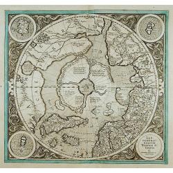
SEPTENTRIONALIUM Terrarum descriptio. Per Gerardum Mercatore
State 2. This is the first map devoted to the Arctic, a hemispherical one on a North Polar projection with an attractive floral design surrounding it. In the corners are ...
Place & Date: Amsterdam 1609
Selling price: $1325
Sold
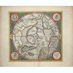
SEPTENTRIONALIUM Terrarum descriptio. Per Gerardum Mercatore.
State 2. This is the first map devoted to the Arctic, a hemispherical one on a North Polar projection with an attractive floral design surrounding it. In the corners are ...
Place & Date: Amsterdam, 1609
Selling price: $2450
Sold in 2013
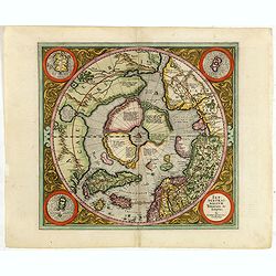
Septentrionalium Terrarum descriptio. Per Gerardum Mercatorem Cum Privilegio.
State 2. This is the first map devoted to the Arctic, a hemispherical one on a North Polar projection with an attractive floral design surrounding it. In the corners are ...
Place & Date: Amsterdam, 1609
Selling price: $2000
Sold in 2015
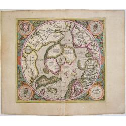
Septentrionalium Terrarum descriptio
This influential map was the first separately printed map devoted to the Arctic. The hemisphere is surrounded by a floral design with four roundels in each corner. These ...
Place & Date: Amsterdam, 1611
Selling price: $1150
Sold in 2011