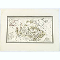
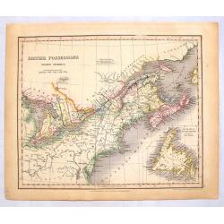
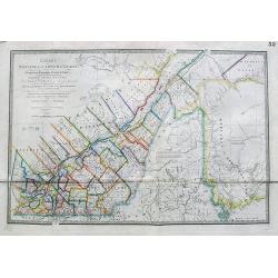
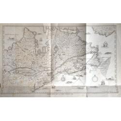
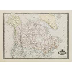
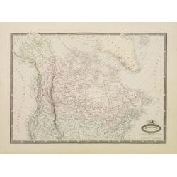
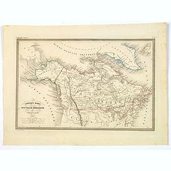
Carte de la partie Septentrionale du Nouveau Monde, ou sont Comprises Les Possessions Anglaises de l'Amerique du Nord. . .
A lovely map of Canada, and 'Amerique Russe'. Countries in outline color, four mileage scales, relief shown by hachures. Good detail of north-west coast of America.With b...
Place & Date: Paris, 1827
Selling price: $95
Sold in 2018
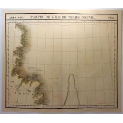
Partie de L'Ile de Terre Neuve. No. 37
A large map of the western side of Newfoundland, extending from Random Head and Flamborough Head to Wolf Island and Table Bay and centered on White Baie and Belle Isle. H...
Place & Date: Brusselles, 1827
Selling price: $27
Sold in 2018
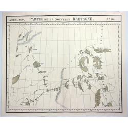
Partie de la Nouvelle Bretagne. No.16.
A hand colored, lithographed, large format map of the region of the 'Esquimaux' and 'Chippeway' lands of Canada. The map provides good topographic details. From Vandermae...
Place & Date: Brusselles, 1827
Selling price: $20
Sold in 2018
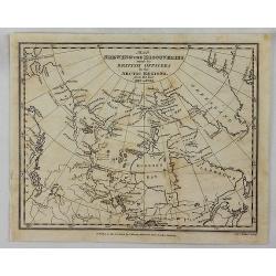
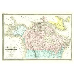
Map Shewing the Discoveries made by British Officers in the Arctic Regions.
A scarce map of northern Canada, the NW coast of America and Greenland, extending to Baffin Bay and the North Georgian Islands, illustrating the British Discoveries in th...
Place & Date: London, 1829
Selling price: $20
Sold in 2018
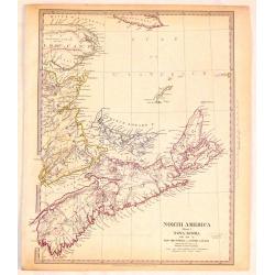
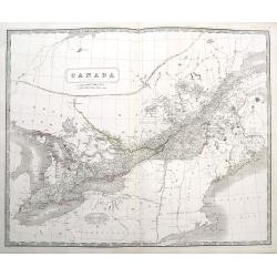
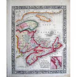
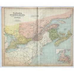
North America (Sheet 1) Nova Scotia with Part of New Brunswick and Lower Canada.
Very detailed sectional map of North America published by Baldwin & Cradock under the superintendence of the Society for the Diffusion of Useful Knowledge in London i...
Place & Date: London, 1833
Selling price: $25
Sold in 2018
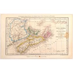
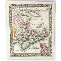
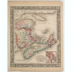
Nova Scotia, New Brunswick, Cape Breton & Prince Edward Island.
A map of the Maritime Provinces of Canada from 33 years before Canada was formed. Published by J. Cochrane & Co for Montgomery Martin's History of the British Coloni...
Place & Date: London, 1834
Selling price: $61
Sold in 2016
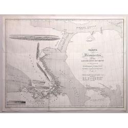
Carte des Découvertes faites dans les régions arctiques en 1829,30,31,32,33. Par John Ross...
An interesting map of an area in the Canadian arctic region 'Nunavut', with parts of Baffin Island, Somerset Island, Baffin Bay, Prince Regent Inlet, and Boothia Gulf.Inc...
Place & Date: Paris, 1835
Selling price: $45
Sold in 2016
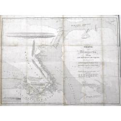
Carte des Decouvertes Faites dans lesRegions Arctiques en 1829-33.
An informative and important map of the discoveries made in the Arctic Regions in 1829-33 by Sir John Ross (1777-1856) in the Hydrographic Office of the Admiralty. Engrav...
Place & Date: Paris, 1835
Selling price: $350
Sold in 2017
British Possessions (North America)
Striking lithograph map of Upper & Lower Canada featuring a cutout of Newfoundland. Published in 1836 by Orr & Company in London 31 years before the formation of ...
Place & Date: London, 1836
Selling price: $40
Sold in 2014
Amérique Ruse, Nouvelle Bretagne et Groenland.
Detailed map of Canada and Alaska.From Malte-Brun's Atlas Géographie Universelle.., revised by Jean Jacques Nicolas Huot.This very fine executed map has been printed by ...
Place & Date: Paris 1837
Selling price: $40
Sold
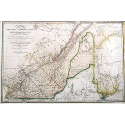
A New Map of the province of Lower Canada, describing all the Signeuries, Townships, Grants of Land, &c. . .
A large and important map of lower Canada, illustrating the land grants on either side of the St. Lawrence River. The disputed boundary line with the United States (with ...
Place & Date: London, 1838
Selling price: $259
Sold in 2017
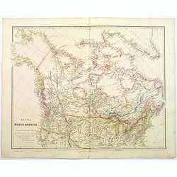
British North America.
A beautiful, large scale map of Canada, and the northern most states of America. Dedicated to the Hon. Hudsons Bay Company. It clearly shows the vastness of this fascinat...
Place & Date: London, 1839
Selling price: $250
Sold in 2020
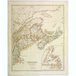
Lower Canada, New Brunswick, Nova Scotia, Prince Edward Island. . .
The prefix "lower" in its name refers to its geographic position farther downriver from the headwaters of the St. Lawrence River than its contemporary Upper Can...
Place & Date: London, 1839
Selling price: $125
Sold in 2020
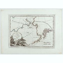
Le Coste Nord Ovest Dell'America e Nord Est dell'Asia Delineate sulle ultime Osservazioni del Cap. Cook
Cassini’s splendid early map of Cook's exploration of the Bering Strait, made on his Third and final voyage. The title is within a decorative title cartouche depicting ...
Place & Date: Rome, Calcography, 1798-before 1839
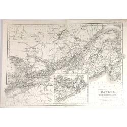
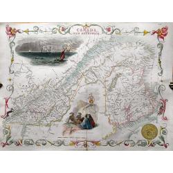
Canada, New Brunswick & c.
Fine map of Maritime part of Canada from Adam & Black's "General Atlas" published in Edinburgh in 1840.It includes Upper (Ontario) & Lower (Quebec) Cana...
Place & Date: Edinbugh. 1840
Selling price: $25
Sold in 2015
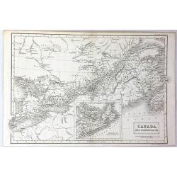
Canada, New Brunswick & c.
A fine example of Adam and Charles Black's map of Canada. It covers from Malden to Cape Breton Island in Nova Scotia. The continuation of Nova Scotia is included in an in...
Place & Date: Edinburgh, 1840
Selling price: $21
Sold in 2016
Quebec or Province of Lower Canada, Describing all the Seigneuries, Townships, Grants of Land, &c...
A large and important map of lower Canada, by or after Wyld, illustrating the land grants on either side of the St. Lawrence River. The boundary line of the United States...
Place & Date: London, ca 1840
Selling price: $125
Sold in 2017
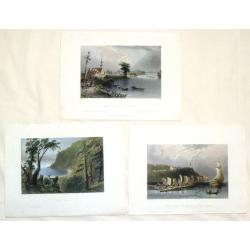
Three Hand-colored Engravings of Quebec, Canada.
Three fine hand-colored Bartlett steel engravings of scenes in Quebec, Canada including: "Village of Cedars, River St. Lawrence", "Wolfe's Cove", and ...
Place & Date: London, 1842
Selling price: $20
Sold in 2016
EAST CANADA AND NEW BRUNSWICK.
Detailed map of the area from Montreal to New Brunswick. Highly decorative map with an inset view of Quebec, a scene of North American Indians, and the ornamental borders...
Place & Date: London, c1850
Selling price: $70
Sold in 2013
Champlain's Map of New France 1632.
FROM 1850 NEW YORKSTATE HISTORY. - A nineteenth century lithograph reproduction of a seminal map.
Place & Date: (1632) 1850
Selling price: $160
Sold in 2014
Champlain's Map of New France 1632.
FROM 1850 NEW YORKSTATE HISTORY. A nineteenth century lithograph reproduction of a seminal map.
Place & Date: New York, 1850
Selling price: $100
Sold in 2015
Canada
A large and highly detailed map of the area between Lake Huron and the Gulf of the Saint Lawrence River, complete with references to the Townships, notes about Indians, a...
Place & Date: Edinburgh, ca 1850
Selling price: $40
Sold in 2016
British America.
A very decorative steel-engraved map of Canada, highly detailed with place names, rivers, mountains, islands, bays, etc. Attractively illustrated with vignette style vie...
Place & Date: London, ca. 1850
Selling price: $25
Sold in 2017
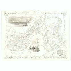
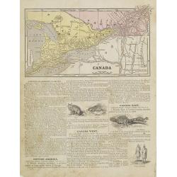
East Canada and New Brunswick.
This is John Tallis’ map of East Canada, or what is now Quebec and New Brunswick. Includes Montreal, Quebec City, and the St. Lawrence River valley. Features five vigne...
Place & Date: London, 1851
Selling price: $55
Sold in 2016
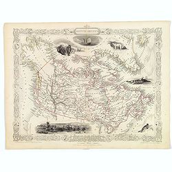
British America.
A decorative and useful map of modern day Canada, when it was still under British rule in the mid nineteenth century. Provinces are outlined in red, with additional annot...
Place & Date: London, 1851
Selling price: $170
Sold in 2016
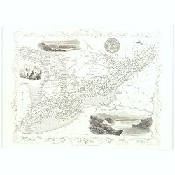
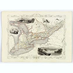
West Canada.
This is John Tallis’ attractive map of West Canada. The map is surrounded by a number of topical steel engraved vignettes, including Niagara Falls, Kingston, Indians, B...
Place & Date: London, 1851
Selling price: $55
Sold in 2016
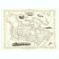
British America.
A decorative and useful map of modern day Canada, when it was still under British rule in the mid nineteenth century. Provinces are outlined in red, with additional annot...
Place & Date: London, 1851
Selling price: $75
Sold in 2022
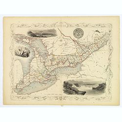
West Canada.
This is John Tallis’ attractive map of West Canada. The map is surrounded by a number of topical steel engraved vignettes, including Niagara Falls, Kingston, Indians, B...
Place & Date: London, 1851
Selling price: $58
Sold in 2018
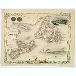
Nova Scotia and Newfoundland.
A decorative and attractive map of the Canadian provinces of Nova Scotia and Newfoundland. The map is enhanced by the seals of both provinces, plus delightful vignettes o...
Place & Date: London, 1851
Selling price: $48
Sold in 2020
West Canada.
This is John Tallis’ attractive map of West Canada. The map is surrounded by a number of topical steel engraved vignettes, including Niagara Falls, Kingston, Indians, B...
Place & Date: London, 1851
Selling price: $48
Sold in 2019
Canada.
Map of Canada. On the verso, a world map of North and South America with its northern and southern hemispheres. From Sidney E. Morse''s: System of Geography for the use o...
Place & Date: New York, 1855
Selling price: $20
Sold in 2015
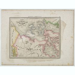
Mari e Arcipelaghi Polari Artici dalla Baia d'Hudson all' America Russa.
Uncommon map of Canada prepared by Francesco Costantino Marmocchi. Above the map "Geografia Commerciale". From "Il Globo Atlante di carte Geografiche compi...
Place & Date: Genova, Paolo Rivara fu Giacomo, 1858
Selling price: $15
Sold in 2020
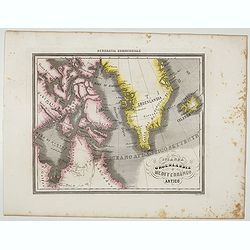
Islanda Groenlandia e Mediterraneo Artico.
Uncommon map of Canada, Greenland and Iceland prepared by Francesco Costantino Marmocchi. Above the map "Geografia Commerciale". From "Il Globo Atlante di ...
Place & Date: Genova, Paolo Rivara fu Giacomo, 1858
Selling price: $25
Sold in 2021
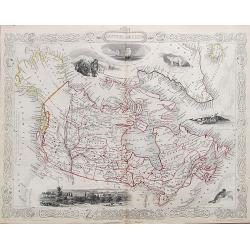
Amérique Boréale, Nouv.le Bretagne & Canada.
Very detailed map from Atlas Sphérodïdal & Universel de géographie , Prepared by F.A.Garnier and edited by Jules Renouard, rue de Tournon, Paris.Uncommon map with ...
Place & Date: Paris 1860
Selling price: $150
Sold
County Map of Nova Scotia, New Brunswick, Cape Breton Island...
County Map of Nova Scotia, New Brunswick, Cape Breton Island and Prince Edward Island Samuel August Mitchell, (1792 - 1868). A native of Scotland, Mitchell was a prolif...
Place & Date: Pennsylvania, 1860
Selling price: $26
Sold in 2010
County Map of Nova Scotia, New Brunswick, Cape Breton Island and Prince Edward Island
A pleasing map of the Canadian Maritime Provinces, with attention to both political and geographical elements. Complete with inset of the city of Halifax. Map is surround...
Place & Date: Philadelphia, 1860
Selling price: $45
Sold in 2016
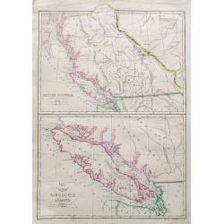
British Columbia (New Caledonia); Vancouver Island;
Two maps on one sheet. Both maps are very detailed, with many place names of rivers, islands, towns, forts, etc. The map of Vancouver shows the island in considerable sca...
Place & Date: London, ca. 1860
Selling price: $65
Sold in 2018
Canada, New Brunswick, Nova Scotia, Cape Breton Island, Prince Edward Island and Newfoundland.
A fine, large, chromolithograph map of the Maritime provinces of Canada. Published by George Philip & Son of London in 1860 – 7 years before Canada was formed. New...
Place & Date: London, 1860
Selling price: $22
Sold in 2019
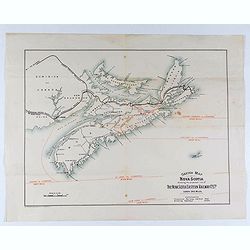
Sketch map of Nova Scotia showing the proposed line of the Nova Scotia eastern railway . . .
Lithograph map of Nova Scotia showing the proposed line of the Nova Scotia Eastern Railway.
Place & Date: London, ca. 1860
Selling price: $60
Sold in 2021
Amérique Boréale, Nouv.le-Bretagne & Canada.
Very detailed map from Atlas Sphérodoïdal & Universel de géographie , Prepared by F.A.Garnier and edited by Jules Renouard, rue de Tournon, Paris. Uncommon map wit...
Place & Date: Paris, 1861
Selling price: $90
Sold in 2016
County Map of Nova Scotia, New Brunswick, Cape Breton Island & Prince Edward's Island.
An attractive map of the Canadian Maritime Provinces, with a small inset map of the city and harbor of Halifax. The map pays attention to both political and geographical ...
Place & Date: Pennsylvania, 1864
Selling price: $75
Sold in 2023
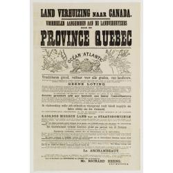
Land Verhuizing naar Canada..
A rare pamphlet in order to stimulate immigration of Belgium farmers to the province of Quebec.In top two maps, one of western Europe and one of eastern Canada. The pamph...
Place & Date: Antwerp c.1870
Selling price: $140
Sold
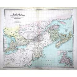
Canada, New Brunswick, Nova Scotia, Cape Breton Island, Prince Edward Island and Newfoundland.
A large map of the South-East of Canada, including the United States until Virginia and Chesapeake Bay. Complete with an inset map of Newfoundland.Highly detailed, with m...
Place & Date: London, ca 1870
Selling price: $29
Sold in 2016
Amerique Russe, Nouvelle Bretagne et Groenland.
A map showing the newly acquired U.S. land of Alaska, newly acquired from Russia, all of Canada and Greenland. The United States purchased Alaska from the Russian Empire ...
Place & Date: Paris, ca 1870
Selling price: $40
Sold in 2019
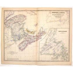
Dominion of Canada (Western Sheet).
Nice hand-colored lithographed map of the Dominion of Canada (Western Sheet). Engraved& printed by W & A.K. Johnston of Edinburgh. Published in London by William ...
Place & Date: Edinburgh, 1875
Selling price: $20
Sold in 2014
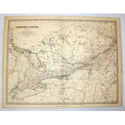
Dominion of Canada.
A fine map of the eastern part of Canada with a large insert of Newfoundland. Alexander Keith Johnston (1804 – 1871) was a Scottish geographer. After being apprentice...
Place & Date: Edinburgh, 1878
Selling price: $1
Sold in 2013
![Animated Map[s] of New Brunswick / Quebec / Ontario / Manitoba.](/uploads/cache/45892-250x250.jpg)
Animated Map[s] of New Brunswick / Quebec / Ontario / Manitoba.
A set of four lovely provincial Canadian map liberally spiced with a touch of humor. Beginning with New Brunswick the map shows us the lay of the land, with a lot of char...
Place & Date: Canadian Ministry for the Interior, ca 1931
Selling price: $51
Sold in 2020
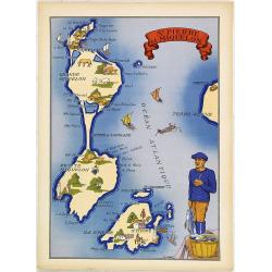
St. Pierre et Miquelon.
Very decorative, informative map of St. Pierre et Miquelon. The map is filled with buildings, animals, ships and boats, figures, and a local in the typical dress.In the l...
Place & Date: France, 1943
Selling price: $60
Sold in 2011
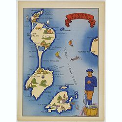
St. Pierre et Miquelon.
Very decorative, informative map of St. Pierre and Miquelon. The map is filled with buildings, animals, ships and boats, figures, and a local in the typical dress.In the ...
Place & Date: France, 1943
Selling price: $55
Sold in 2016
![Skiing map and Information. [Camp Fortune]](/uploads/cache/40048-250x250.jpg)
Skiing map and Information. [Camp Fortune]
A nice folding map of the Camp Fortune Ski area 25 miles from downtown Ottawa.Map takes the form of showing all the various tracks and routes available to skiers at Camp ...
Place & Date: Ottawa, ca. 1960
Selling price: $65
Sold in 2017
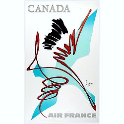
Canada.
Decorative poster advertising flights to Canada made by Georges Mathieu. The poster is one of a series of 15 composed of posters of Greece, Israel, Germany, Great Britai...
Place & Date: Paris, 1967
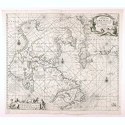
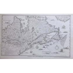
Pascaarte vande Noorder Zee Custen van America, vande West-Hoeck van Ysland doorde...
Fourth and last edition of van Keulen's chart of the Arctic Canada with the Hudson Bay and the supposed Northwest Passage. First published in 1680. The map is based upon ...
Place & Date: Amsterdam, 1728-80
Selling price: $600
Sold in 2020