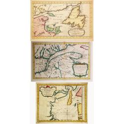
Carte des Parties du Nord-Ouest de l' Amerique./Carte des Parties du Nord-Ouest de l' Amerique. / Carte du Golphe de St. Laurent et Pays Voisins. / 3 maps by Bellin
Jacques Nicolas Bellin (1702-720) was the most important French hydrographer of the 18th century. Sea-atlas 'Hydrographique Français' , 1756-65, atlas to accompany Prév...
Place & Date: Amsterdam, 1777
Selling price: $205
Sold in 2021
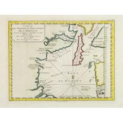
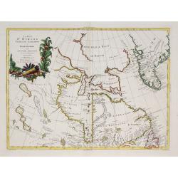
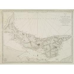
Carte Des Parties Du Nord-Ouest De L'Amerique Suivant les Voyages de Middleton et d Ellis en 1742 et 1746..
Uncommon Dutch edition of this attractive map prepared by J. N. Bellin. Map of the Hudson Bay area. Bellin was quite confused about the settlements (York Factory, Port Ne...
Place & Date: Amsterdam, 1777
Selling price: $100
Sold in 2023
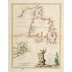
Le Isole di Terra Nuova e Capo Breton .
Newfoundland and Cape Breton. The title vignette shows fish being dried, an indication of the importance of the fishing industry there. Published in Zatta's "Atlante...
Place & Date: Venice 1778
Selling price: $300
Sold
La Baja D'Hudson Terra di Labrador e Groenlandia.
Decorative map of Nova Scotia, Hudson Bay and part of Greenland. With many names of villages, as well engraved mountains and rivers are shown.Published in Zatta's "A...
Place & Date: Venice, 1778
Selling price: $130
Sold in 2009
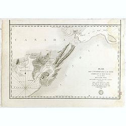
Plan de L'ile de St. Jean Au nord de l'Acadie. . .
Chart of Prince Edward Island with Charlotte town. Named after Queen Charlotte, the wife of George III.After Dutch and British sources. Engraved by Petit and edited by th...
Place & Date: Paris, 1778
Selling price: $210
Sold in 2010
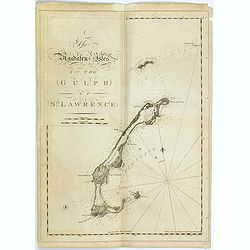
The Magdalen-Isles in the Gulph of St. Lawrence.
A chart of part of Canada taken from the "Atlantic Neptune", and marked in lower right corner "Published according to Act of Parliament Jan. The 20th 1778 ...
Place & Date: London, 1778
Selling price: $550
Sold in 2015
![[Miramichi Bay]](/uploads/cache/35775-250x250.jpg)
[Miramichi Bay]
A chart of part of Canada taken from the "Atlantic Neptune", and marked in lower right corner "Published according to Act of Parliament Jan. The 20th 1778 ...
Place & Date: London, 1778
Selling price: $500
Sold in 2015
![[Harbour and bay of Gaspee]](/uploads/cache/35776-250x250.jpg)
[Harbour and bay of Gaspee]
A chart of part of Canada taken from the "Atlantic Neptune", and marked in lower right corner "Published according to Act of Parliament Jan. The 20th 1778 ...
Place & Date: London, 1778
Selling price: $650
Sold in 2015
![[The south east coast of the island of St John]](/uploads/cache/35777-250x250.jpg)
[The south east coast of the island of St John]
A chart of part of Canada taken from the "Atlantic Neptune", and marked in lower right corner "Published according to Act of Parliament Jan. The 20th 1778 ...
Place & Date: London, 1778
Selling price: $550
Sold in 2015
![[Carigan Bay]](/uploads/cache/35778-250x250.jpg)
[Carigan Bay]
A chart of part of Canada taken from the "Atlantic Neptune", and marked in lower right corner "Published according to Act of Parliament Jan. The 20th 1778 ...
Place & Date: London, 1778
Selling price: $600
Sold in 2015
![[Bay of Seven islands]](/uploads/cache/35779-250x250.jpg)
[Bay of Seven islands]
A chart of part of Canada taken from the "Atlantic Neptune", and marked in lower right corner "Published according to Act of Parliament Jan. The 20th 1778 ...
Place & Date: London, 1778
Selling price: $500
Sold in 2015
![[Bay of Chaleurs]](/uploads/cache/35780-250x250.jpg)
[Bay of Chaleurs]
A chart of part of Canada taken from the "Atlantic Neptune", and marked in lower right corner "Published according to Act of Parliament Jan. The 20th 1778 ...
Place & Date: London, 1778
Selling price: $500
Sold in 2015
![[A chart of the N.E.Coast of Cape Breton Island]](/uploads/cache/35781-250x250.jpg)
[A chart of the N.E.Coast of Cape Breton Island]
A chart of part of Canada taken from the "Atlantic Neptune", and marked in lower right corner "Published according to Act of Parliament Jan. The 20th 1778 ...
Place & Date: London, 1778
Selling price: $500
Sold in 2015
![[The south east coast of Cape Breton Island]](/uploads/cache/35782-250x250.jpg)
[The south east coast of Cape Breton Island]
A chart of part of Canada including fort Louisbourg, taken from the "Atlantic Neptune", and marked in lower right corner "Published according to Act of Par...
Place & Date: London, 1778
Selling price: $750
Sold in 2015
![[The south east coast of Cape Breton Island]](/uploads/cache/35783-250x250.jpg)
[The south east coast of Cape Breton Island]
A chart of part of Canada taken from the "Atlantic Neptune", and marked in lower right corner "Published according to Act of Parliament Jan. The 20th 1778 ...
Place & Date: London, 1778
Selling price: $500
Sold in 2015

Plan du Bassin et de la Riviere du Port Royal ou Annapolis, dans l'Acadie sur la Cote Orientale de la Baie Francois . . .
Revolutionary war sea the Bay of Annapolis Royal, a small Canadian town located in the western part of Annapolis County, Nova Scotia, and was known as Port Royal until t...
Place & Date: Paris, 1778
Selling price: $130
Sold in 2016
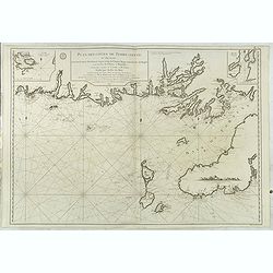
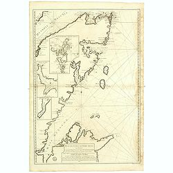
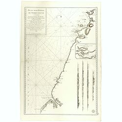
Plan des Côtes de Terre-Neuve, II ème Feuille..
Fine 1784 sea . of the southwest coast of Newfoundland, Canada, issued by the Depot de la Marine and surveyed by Captain Cook. This map, the second in this series. The F...
Place & Date: Paris, 1778
Selling price: $200
Sold in 2016
![[Grand Bay of Pasamaquody, St. Croi.x River, Etang Harbour, Beaver Harbour, etc]](/uploads/cache/36361-250x250.jpg)
[Grand Bay of Pasamaquody, St. Croi.x River, Etang Harbour, Beaver Harbour, etc]
This superb
Place & Date: London, ca.1778
Selling price: $2700
Sold in 2015
![[Coast of Maine showing Blue Hill Bay, Penobscot Bay, Belfast Bay, Islesboro Island, Deer Island, and other islands.]](/uploads/cache/36362-250x250.jpg)
[Coast of Maine showing Blue Hill Bay, Penobscot Bay, Belfast Bay, Islesboro Island, Deer Island, and other islands.]
A chart of coast of Maine showing Blue Hill Bay, Penobscot Bay, Belfast Bay, Islesboro Island, Deer Island, and other islands taken from the "Atlantic Neptune",...
Place & Date: London, 1778
Selling price: $5350
Sold in 2015
![[Coast of Maine showing Blue Hill Bay, Penobscot Bay, Belfast Bay, Islesboro Island, Deer Island, and other islands.]](/uploads/cache/36483-250x250.jpg)
[Coast of Maine showing Blue Hill Bay, Penobscot Bay, Belfast Bay, Islesboro Island, Deer Island, and other islands.]
A chart of coast of Maine showing Casco Bay taken from the "Atlantic Neptune", no date.Henry Stevens identified six states of the chart. This superb
Place & Date: London, ca. 1778
Selling price: $1500
Sold in 2015
![[The south east coast of Cape Breton Island]](/uploads/cache/36484-250x250.jpg)
[The south east coast of Cape Breton Island]
A chart of part of Canada taken from the "Atlantic Neptune", and marked in lower right corner "Published according to Act of Parliament Jan. The 20th 1778 ...
Place & Date: London, 1778
Selling price: $600
Sold in 2016
![[A chart of the N.E.Coast of Cape Breton Island]](/uploads/cache/36485-250x250.jpg)
[A chart of the N.E.Coast of Cape Breton Island]
A chart of part of Canada taken from the "Atlantic Neptune", and marked in lower right corner "Published according to Act of Parliament Jan. The 20th 1778 ...
Place & Date: London, 1778
Selling price: $500
Sold in 2015
Plan des Côtes de Terre-Neuve, IV ème Feuille..
Revolutionary war sea .Relief shown by hachures. Depths shown by soundings. Below engraved seal of Depot General de la Marine. Prepared under the direction of de Maréch...
Place & Date: Paris, 1778
Selling price: $100
Sold in 2017
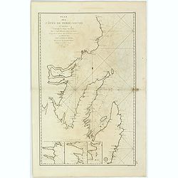
Plan des Côtes de Terre-Neuve, VI ème Feuille. . .
Revolutionary war sea of the Strait of Belle Isle (Beautiful Island) which is a waterway in eastern Canada that separates the Labrador Peninsula from the island of Newfo...
Place & Date: Paris, 1778
Selling price: $100
Sold in 2017
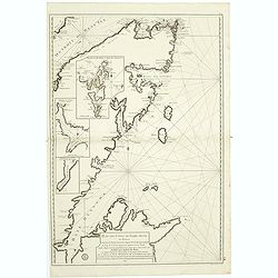
Plan des Côtes de Terre-Neuve, II ème Feuille. . .
Fine 1784 sea of the southwest coast of Newfoundland, Canada, issued by the Depot de la Marine and surveyed by Captain Cook. This map, the second in this series. The Fre...
Place & Date: Paris, 1778
Selling price: $200
Sold in 2017
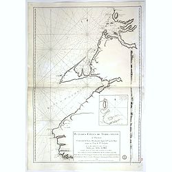
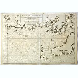
Carte du cours du fleuve de Saint Laurent depuis la Mer jusqu a Quebec. . .
Revolutionary war sea of the St Lawrence river at its estuary . With 4 insets and a large title cartouche.Relief shown by hachures. Depths shown by soundings. Below engr...
Place & Date: Paris, 1778
Selling price: $105
Sold in 2018
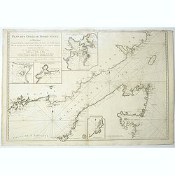
Plan de la baie de Saint-Lunaire, à la côte nord-est de Terre-Neuve. . .
Revolutionary war sea of the bay de Saint-Lunaire, in New Foundland, Canada.Relief shown by hachures. Depths shown by soundings. Below engraved seal of Depot General de ...
Place & Date: Paris, 1778
Selling price: $105
Sold in 2018
Plan des Côtes de Terre-Neuve: IXe Feuille..
Revolutionary war sea .Relief shown by hachures. Depths shown by soundings. Below engraved seal of Depot General de la Marine. Prepared under the direction of de Maréch...
Place & Date: Paris, 1778
Selling price: $100
Sold in 2018
Plan des Côtes de Terre-Neuve: IXe Feuille..
Revolutionary war sea .Relief shown by hachures. Depths shown by soundings. Below engraved seal of Depot General de la Marine. Prepared under the direction of de Maréch...
Place & Date: Paris, 1778
Selling price: $100
Sold in 2018
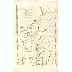
Plan des Côtes de Terre-Neuve, VII ème Feuille..
Revolutionary war sea of New Foundland.Relief shown by hachures. Depths shown by soundings. Below engraved seal of Depot General de la Marine. Prepared under the directi...
Place & Date: Paris, 1778
Selling price: $60
Sold in 2018
Plan des Côtes de Terre-Neuve, VII ème Feuille..
Revolutionary war sea of New Foundland .Relief shown by hachures. Depths shown by soundings. Below engraved seal of Depot General de la Marine. Prepared under the direct...
Place & Date: Paris, 1778
Selling price: $175
Sold in 2018
Plan des Côtes de Terre-Neuve, V ème Feuille..
Revolutionary war sea of New Foundland.Relief shown by hachures. Depths shown by soundings. Below engraved seal of Depot General de la Marine. Prepared under the directi...
Place & Date: Paris, 1778
Selling price: $120
Sold in 2018
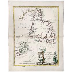
Le Isole di TERRA NUOVA e CAPO BRETON Di Nuova Projezione.
A gorgeous separate map of Newfoundland and Cape Breton Island, along with neighbouring Islands, including St. Pierre Michelon. An old outlined colored map with a cartouc...
Place & Date: Venice, 1778
Selling price: $120
Sold in 2019
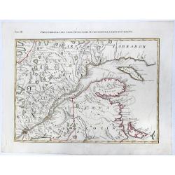
PARTE ORIENTALE DEL CANADA, NUOVA SCOZIA SETTENTRIONALE, E PARTE DI LABRADOR. (Fogl. III.)
A striking and detailed, important regional map, dissected diagonally by the St Lawrence and showing a portion of Southeastern Canada. This map is a part of the Italian e...
Place & Date: Venice, 1778
Selling price: $160
Sold in 2020
La Baja d' Hudson terra di Labrador e Groenlandia....
Great map of parts of Canada with Hudson Bay, Baffin Bay, Labrador, and Greenland. With many details such as Forts, settlements, bays, islands, indian regions, and unfini...
Place & Date: Venice, 1778
Selling price: $100
Sold in 2020
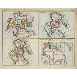
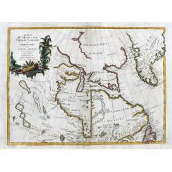
Carte qui représnte ? Terres Arctiques ... Suppl.Carte 9.
From Diderot's Encyclopaedia. Four maps on one sheet showing Hudson Bay according to Sanson's map of 1750 and De L'Isle 1700 and 1703. One map showing track of Henri Elli...
Place & Date: Paris, 1779
Selling price: $50
Sold in 2010
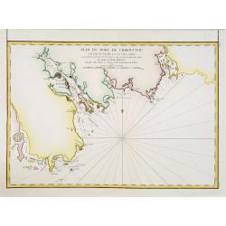
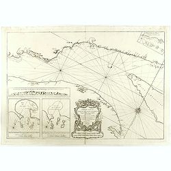
Plan du port de Chibouctou à la cote de l'Acadie avec les cotes voisines. . .
Chart of the vicinity of Halifax Harbor from Chebucto Head to the head of Bedford Basin.Issued in Neptune americo-septentrionale by "Depot Général de la Marine&quo...
Place & Date: Paris, 1779
Selling price: $200
Sold in 2013
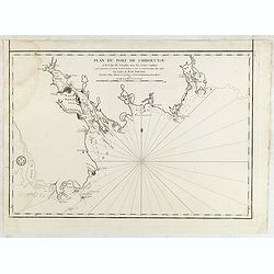
Plan du port de Chibouctou à la cote de l'Acadie avec les cotes voisines. . .
French chart of the vicinity of Halifax Harbor from Chebucto Head to the head of Bedford Basin.Issued in Neptune americo-septentrionale by "Depot Général de la Mar...
Place & Date: Paris, 1779
Selling price: $210
Sold in 2015
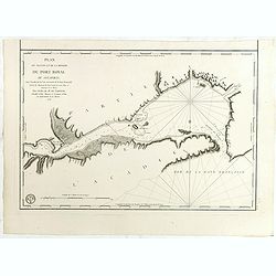
Plan du Bassin et de la Riviere du Port Royal ou Annapolis, dans l'Acadie sur la Cote Orientale de la Baie Francois . . .
French chartof the Bay of Annapolis Royal, a small Canadian town located in the western part of Annapolis County, Nova Scotia, and was known as Port Royal until the Conqu...
Place & Date: Paris, 1779
Selling price: $67
Sold in 2018
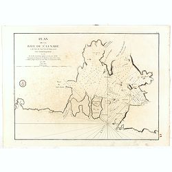
Plan de l'isthme de l'Acadie comprenant le Beau-Bassin avec une partie de la Baie Verte...
French chart of the Isthmus of Chignecto, an isthmus bordering the Maritime provinces of New Brunswick and Nova Scotia, Canada. Made under the direction of M. de Sartine....
Place & Date: Paris, ca.1779
Selling price: $80
Sold in 2017