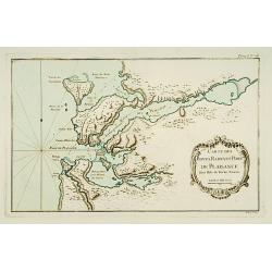
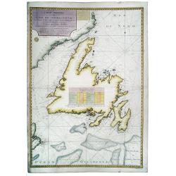
Carte des Bayes, Rades et Port de Plaisance dans l'Isle de Terre-Neuve.
This chart shows the territories of the bay and harbour of Plaisance on New Found land.The only issue of this version of Bellin's map, slightly larger than the common ver...
Place & Date: Paris 1764
Selling price: $65
Sold
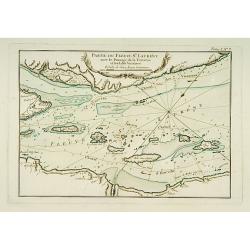
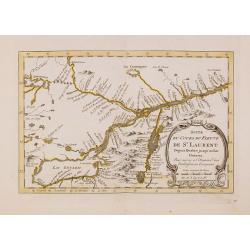
Partie du Fleuve de Saint Laurent avec le Passage de la Traverse et des Isles Voisines.
Striking chart shows islands in the St. Lawrence River in the channels east/northeast of Isle D'Orleans. Locates the Iberville Channel & the current ship channel used...
Place & Date: Paris 1764
Selling price: $40
Sold
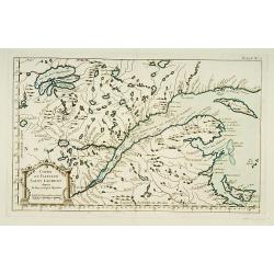
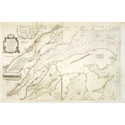
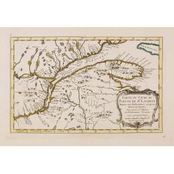
Cours du Fleuve de Saint Laurent depuis la Mer jusqu'à Québec.
Handsome chart shows the lands on both sides of the St. Lawrence River from the Gulf to Quebec. Includes the Gaspe Peninsula, Chaleurs Bay, Isle St. Jean (Prince Edward I...
Place & Date: Paris 1764
Selling price: $70
Sold
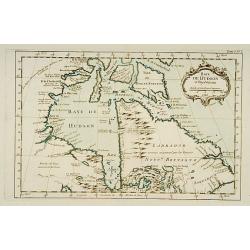
Baye de Hudson et Pays Voisins.
This chart shows the territories of Hudson Bay.The only issue of this version of Bellin's map, slightly larger than the common version. Depths shown by soundings.From Bel...
Place & Date: Paris 1764
Selling price: $70
Sold
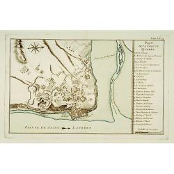
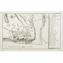
Plan de la Ville de Québec.
A detailed plan the territories of city of Québec. With a lettered key, indicating the principal places in town.The only issue of this version of Bellin's map, slightly ...
Place & Date: Paris 1764
Selling price: $100
Sold
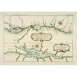
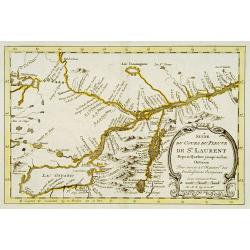
Partie du Fleuve St. Laurent depuis Québec jusqu'au Lac St. François. / Carte du Lac Champlain.
Two charts on one sheet. The upper chart showing the river S.Laurence from Quebec. The lower chart is a detailed depiction of Lake Champlain.The only issue of this versio...
Place & Date: Paris 1764
Selling price: $92
Sold
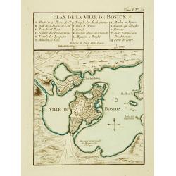
Plan de la Ville de Boston.
One of the earliest obtainable town plans of Boston, from Bellin's Petit Atlas Maritime. Shows Boston 13 years prior to the American Revolution.The only issue of this ver...
Place & Date: Paris 1764
Selling price: $230
Sold
![Carte de la Baye de Baston. [Boston]](/uploads/cache/17094-250x250.jpg)
Carte de la Baye de Baston. [Boston]
A nice chart of the bay and city plan of Boston. Islands and navigation hazards are all clearly marked. Fleur-de-lys and rhumb lines.The only issue of this version of Bel...
Place & Date: Paris 1764
Selling price: $200
Sold
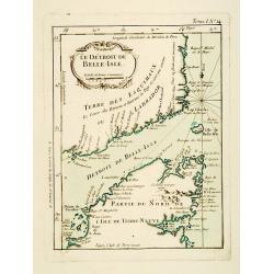
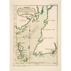
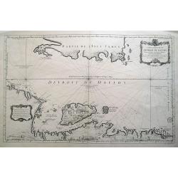
Le Détroit de Belle-Isle.
This chart shows the territories of Strait of Belle-Isle with parts of Labrador and northern part of Newfound land.The only issue of this version of Bellin's map, slightl...
Place & Date: Paris 1764
Selling price: $50
Sold
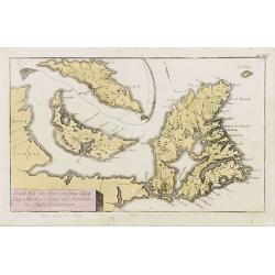
Carte des Isles de Miquelon et de St. Pierre et la Coste de Terre Neuve voisine.
This chart shows the territories of the Miquelon islands and St Pierre.The only issue of this version of Bellin's map, slightly larger than the common version. Depths sho...
Place & Date: Paris 1764
Selling price: $60
Sold
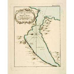
Carte du Havre de Saint-Jean dans l'Isle de Terre-neuve.
This chart shows the territories of the harbour of Saint-Jean on New Found land.The only issue of this version of Bellin's map, slightly larger than the common version. D...
Place & Date: Paris 1764
Selling price: $50
Sold
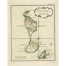
Carte Des Isles De St. Pierre et de Miquelon.
This chart shows the territories of the islands of St. Pierre and Miquelon.The only issue of this version of Bellin's map, slightly larger than the common version. Depths...
Place & Date: Paris 1764
Selling price: $79
Sold
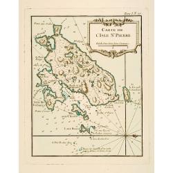
Carte de l'Isle de St. Pierre.
This chart shows the territories of the island of St. Pierre in New Found land.The only issue of this version of Bellin's map, slightly larger than the common version. De...
Place & Date: Paris 1764
Selling price: $62
Sold
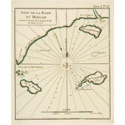
Idée de La Rade du Mingan. Suivant le Journal de la Fregate du Roy La Diane en 1755.
An engraved chart showing part of the mainland and three islands on New Found land.The only issue of this version of Bellin's map, slightly larger than the common version...
Place & Date: Paris 1764
Selling price: $15
Sold
Plan de la Ville de Québec.
A detailed plan the territories of city of Québec. With a lettered key, indicating the principal places in town.The only issue of this version of Bellin's map, slightly ...
Place & Date: Paris, 1764
Selling price: $300
Sold in 2021
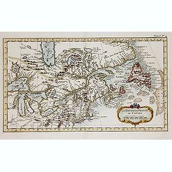
La Nouvelle France où Canada.
This chart shows the territories of New-France and Canada the day before the signature of the treaty of Paris.The only issue of this version of Bellin's map, slightly lar...
Place & Date: Paris, 1764
Selling price: $181
Sold in 2013
Carte Reduite du Detroit de Davids...
Highly interesting large-scale sea chart of the Davis Strait, which was created for whaling ships, and illustrates the importance of offshore activities in the region. Or...
Place & Date: Paris, 1765
Selling price: $199
Sold in 2018
Carte de L'Ile de Terre-Neuve. Dressee d'apres les Plans Anglois de James Cook et Michael Lane. . .
A fine early sea chart of the Newfoundland and Labrador based upon early 18th century works , published by the French Hydrographical Department. This chart was produced b...
Place & Date: Paris, 1765
Selling price: $350
Sold in 2020
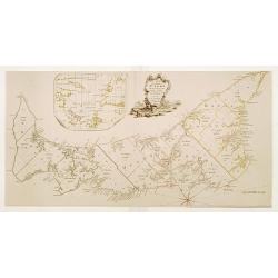
![The Coast of New Found Land From Salmon Cove to Cape Bonavista. . . [together with] The Coast of New Found Land from Cape-Raze to Cape St-Francis.](/uploads/cache/40658-250x250.jpg)
The Coast of New Found Land From Salmon Cove to Cape Bonavista. . . [together with] The Coast of New Found Land from Cape-Raze to Cape St-Francis.
Two charts showing the coast of New Found Land from Salmon Cove to Cape Bonavista and from Cape-Raze to Cape St-Francis. With inset chart of Trinity HarborGrierson publis...
Place & Date: Dublin, 1767
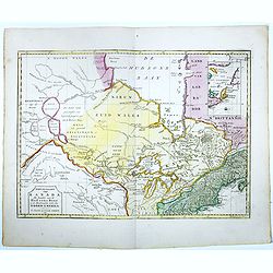
Nieuwe kaart van Kanada . . .
Nice map of the Bay of Hudson, In Labrador a small inset of Nova Scotia. The map is dated 1769. All text is in Dutch. The map shows the region shortly after the conclusio...
Place & Date: Amsterdam, 1769
Selling price: $475
Sold in 2016
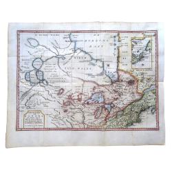
Nieuwe Kaart van Kanada, de Landen aan de Hudsons-Baay en de Noordwestelijke delen van Noord-Amerika
The map is based on Jefferys' important map of Canada in 1760 with a realistic interpretation of Lake Winnipeg. It covers the area from Hudson Bay, through the Great Lake...
Place & Date: Amsterdam, 1769
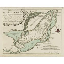
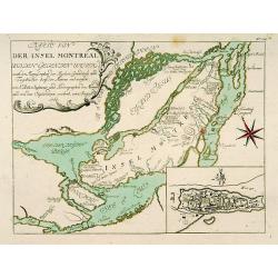
Karte von der Insel Montreal..
A rare issue of a plan of Montreal, published by G.Raspe in \"Schau Plats Des Gegenwaertigen Kriegs ...\". The title, at top left, credits Bellin.
Place & Date: Nürnberg, 1770
Selling price: $400
Sold in 2008
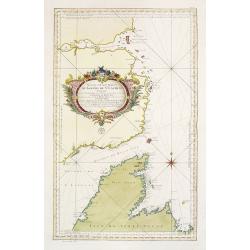
Grund Riss der Americanischen Insuln Cape Breton, St. Iean und Anticosti im Flusse S. Laurencii..
Map representing the eastern part of Nova Scotia, namely Cape Breton and Prince Edward Islands. With an inset map of Anticosti Island on top.
Place & Date: Nurnberg, 1770
Selling price: $235
Sold in 2023
An exact chart of the River St. Laurence, from Fort Frontenac to the Island of Anticosti, shewing the soundings, rocks, shoals &c.
Published in "A General Atlas", with dedication to Jn. Montague, Earl of Sandwich. Dated 1771. This is the fourth state of five. With five insets. A chart of th...
Place & Date: London, Robert Sayer, 1771
Selling price: $900
Sold in 2013
![[Untitled] De Stad Louisburg of van Kaap Breton. . .](/uploads/cache/43969-250x250.jpg)
[Untitled] De Stad Louisburg of van Kaap Breton. . .
A plan of the French Fortress of Louisbourg, and the immediate surrounds. The Fortress today is a National Historic Site of Canada, and the location of a one-quarter part...
Place & Date: Amsterdam, ca 1772
Selling price: $160
Sold in 2019
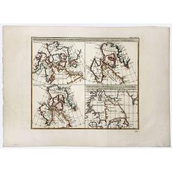
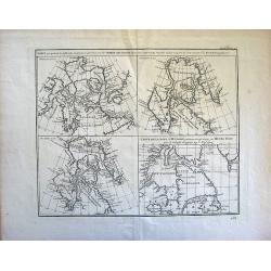
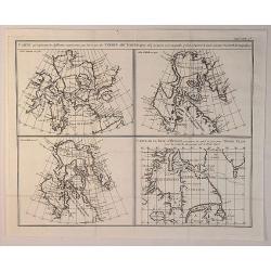
Carte qui represente les differentes connoissances que L'on a eues des Terres Arctiques depuis 1650. . . CARTE DE LA BAYE D' HUDSON.
A beautiful set of four maps of the Hudson, Button and Baffin Bay regions, Davis Straits and the Coast Labrador, showing the evolution of cartography and discoveries of t...
Place & Date: Paris, 1772
Selling price: $50
Sold in 2019
Suite du cours du Fleuve de St.Laurent..
Uncommon edition of this accurate map showing the lower the upper St.Laurence. Second state. From Atlas Portatif pour servir a l'intelligence de l'Histoire Philosophique ...
Place & Date: Amsterdam, 1773
Selling price: $150
Sold in 2013
Map of the Arctic.
Map of the Arctic.
Place & Date: Paris, 1773
Selling price: $11
Sold in 2010
Carte du cours du Fleuve de St.Laurent Depuis son Embouchure..
Scarce edition of this accurate map showing the lower St.Laurence, including Quebec. Second state. In lower right engraved "34b."From Atlas Portatif pour servir...
Place & Date: Amsterdam, 1773
Selling price: $240
Sold in 2014
Suite du cours du Fleuve de St.Laurent Depuis Quebec jusqu'au Lac Ontario..
Scarce edition of this accurate map showing the upper St.Laurence. In lower right engraved "34c."From Atlas Portatif pour servir a l'intelligence de l'Histoire ...
Place & Date: Amsterdam, 1773
Selling price: $300
Sold
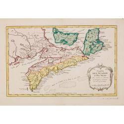
Carte de L'Acadie et Pais Voisins. . .
Scarce edition of this fine map of Maritime Canada. This is an intermediate state between Kershaw 785/786: the map has an engraved nr. 37.Louisburg and Baie Chedabouctou ...
Place & Date: Amsterdam, 1773
Selling price: $200
Sold in 2014
Partie de l'Amerique Septentrionale.. Canada, la Louisiane...
Interesting map of the eastern part of Canada with Hudson Bay, Baffin Bay and Greenland.
Place & Date: Paris/ Bordeaux, 1773
Selling price: $60
Sold in 2018
Carte Qui Represente les Differentes Connoissances que Lion Eues des Terres Arctiques. . .
This magnificent original copper-plate engraved antique maps of 4 different time based views of Hudsons Bay & Eastern Canada by Robert De Vaugondy was engraved in 177...
Place & Date: Paris, 1773
Selling price: $25
Sold in 2020
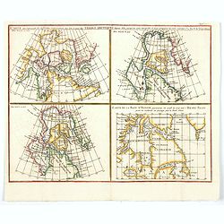
Carte qui represente les différentes connoissances que l'on a eues des Terres Arctiques depuis 1650 jusqu'en 1747. . .
A fascinating group of four maps on the one sheet to illustrate the cartography of Sanson in 1750, Delisle in 1700 and 1703 plus that of the famous Arctic explorer Henry ...
Place & Date: Paris, 1773
Selling price: $50
Sold in 2020
A Map of the Island of St. John in the Golf of St. Laurence
Based on the surveys of Captain Samuel Holland. Published in Thomas Jefferys' "The American Atlas." Detailed map with compass roses and system of rhumb lines, s...
Place & Date: London 1775
Selling price: $925
Sold
Karte von der Insel Montreal..
A rare issue of a plan of Montreal prepared by N.Bellin in 1760. The second state with the added plan of Montreal in lower right corner.
Place & Date: Nurnberg, 1776
Selling price: $475
Sold in 2011
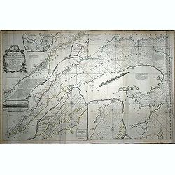
Suite De La Carte Réduite Du Golphe De St. Laurent Contenant Les Costes de Labrador.. (1758
A well engraved and highly detailed chart that was issued in L'hydrographie françoise and is dated 1753. Seal of the Depot de Marine and prix trente Sols. The page numbe...
Place & Date: Paris, 1776
Selling price: $1200
Sold
An exact chart of the River St. Laurence, from Fort Frontenac to the Island of Anticosti, shewing the soundings, rocks, shoals &c.
With five insets. A chart of the St. Lawrence River by the noted eighteenth century English cartographer Thomas Jefferys, Geographer to George III and the Prince of Wales...
Place & Date: London, 1776
Selling price: $400
Sold in 2014
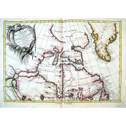
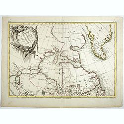
Partie de L'Amerique Septentrionale, qui comprend le Canada,...
Important map of the Hudson Bay and northeastern Canada from Lake Winnipeg to Greenland. It illustrates the French and English searches for the Northwest Passage. With se...
Place & Date: Paris, 1776
Selling price: $132
Sold in 2016
Exact Chart of the River St. Laurence from Fort Frontenac to the Island of Anticosti showing the Soundings, Rocks, Shoals &c. with Views of the Lands and all necessary Instructions for navigating that River to Quebec.
2 sheets joined. 63 x 99 cm. Original outline color (none added).
Place & Date: London, Robert Sayer. 1776
Selling price: $660
Sold in 2020