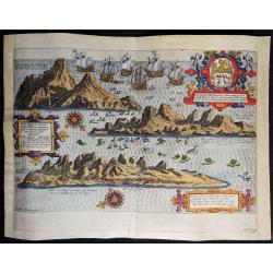
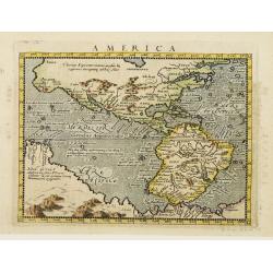
Browse Listings in America
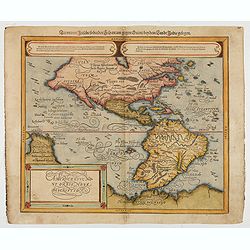
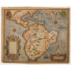
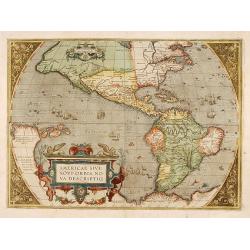
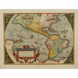
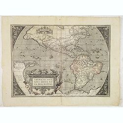
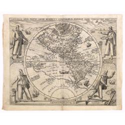
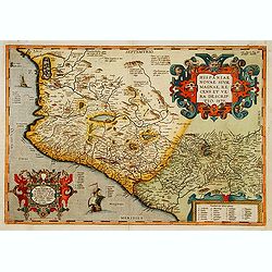
Americae Sive Novi Orbis, Nova Descriptio
Woodcut map by based on Abraham Ortelius' classic map of 1570, with the huge bulge in the southwest coastline of South America, the Ortelian western coastline of North Am...
Date: Basel, ca.1588
Selling price: ????
Please login to see price!
Sold in 2022
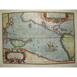
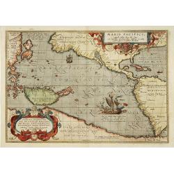
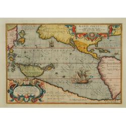
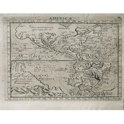
Maris Pacifici.
The first printed map of the Pacific. Acknowledged to be one of the most beautiful and decorative maps which appeared in the Theatrum Orbis Terrarum, it was also one of t...
Date: Antwerp 1589
Selling price: ????
Please login to see price!
Sold
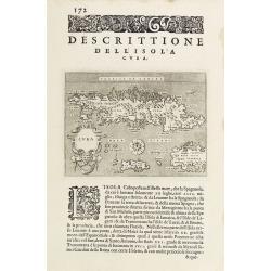
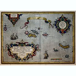
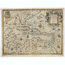
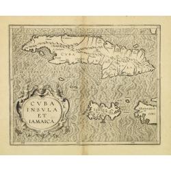
Descrittione dell'Isola Cuba.
Early map of Cuba, published in Venetia, Appresso gli Heredi di Simon Galignani, 1590.
Date: Venise 1590
Selling price: ????
Please login to see price!
Sold
Americae pars, Nunc Virginia dicta, primum ab Anglis. . .
John White's map, elegantly designed and superbly engraved, revolutionized geographic knowledge of the region. Although White left the Chesapeake poorly explored, much of...
Date: Frankfurt, 1590
Selling price: ????
Please login to see price!
Sold
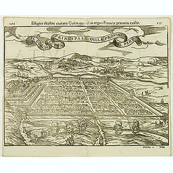
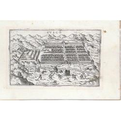
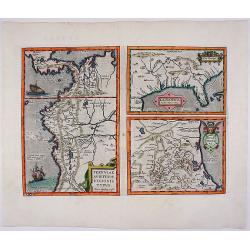
Principale della provincia citta del peru il cuscho.
On recto an early birds-eye view of Cusco. On verso tittle page and a plan of Mexico City "Urbs themistiana hispaniae" (165x162mm.)From a German text edition of...
Date: Basle, 1550-1590
Selling price: ????
Please login to see price!
Sold in 2014
![[Cuba]](/uploads/cache/32579-250x250.jpg)
[Cuba]
On recto a wood block printed map of Cuba (79x123mm.).From a Latin text edition of his Geographia , that great compendium of Renaissance knowledge.
Date: Basle, 1550-1590
Selling price: ????
Please login to see price!
Sold in 2013

Wie die Weiber von Dafamonguepeuc.
Engraving depicting a native American woman of Dasamonguepeuc carrying a child, from Theodorus De Bry's Les Grands Voyages.
Date: Frankfurt, 1590
Selling price: ????
Please login to see price!
Sold in 2013
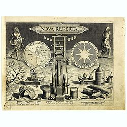
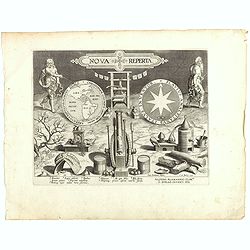
Nova reperta.
Title-page from a series of twenty prints illustrating new inventions and discoveries (Nova Reperta) after Jan van der Straet. Lettered on image: 'NOVA REPERTA'; on left ...
Date: Antwerp, Philips Galle, c. 1590
Selling price: ????
Please login to see price!
Sold in 2018
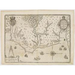
![[The Englishmen's arrival in Virginia with Roanoke Colony - Carolina Coastline] No title.](/uploads/cache/42117-250x250.jpg)
[The Englishmen's arrival in Virginia with Roanoke Colony - Carolina Coastline] No title.
Map showing the coast of Virginia with many islands just off the mainland, two Native territories, Secotan and Weapemeoc, and the Native community of Roanoak on an island...
Date: Frankfurt, c. 1590
Selling price: ????
Please login to see price!
Sold in 2018
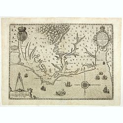
Americae pars, Nunc Virginia dicta, primum ab Anglis. . .
John White's map, elegantly designed and superbly engraved, revolutionized geographic knowledge of the region. Although White left the Chesapeake poorly explored, much of...
Date: Frankfurt, 1590
Selling price: ????
Please login to see price!
Sold in 2019
![La Florida [with] Guastecan](/uploads/cache/florida_01-250x250.jpg)
La Florida [with] Guastecan
A fine, old-colored example of Abraham Ortelius’ seminal map of Florida and the North American South. Ortelius’ map La Florida was the foundation for cartography ...
Date: Antwerp, 1590
Selling price: ????
Please login to see price!
Sold in 2023
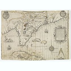
Floridae Americae Provinciae recens & exactissima descriptio . . .
A superb map of the Eastern Seaboard from Cape Lookout to Florida, with Cuba and the Bahamas, by the official artist of the second French Huguenot expedition to their col...
Date: Frankfurt, 1591
Selling price: ????
Please login to see price!
Sold in 2012
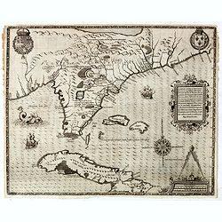
Floridae Americae Provinciae recens & exactissima descriptio . . .
A superb map of the Eastern Seaboard from Cape Lookout to Florida, with Cuba and the Bahamas, by the official artist of the second French Huguenot expedition to their col...
Date: Frankfurt, 1591
Selling price: ????
Please login to see price!
Sold in 2014

French battle with Florida Indians, 1591
Exciting de Bry engraving from 'der ander Theil der newlich erfundenen Landtschafft Americae' showing French soldiers aiding native North Americans in a war against a riv...
Date: Frankfurt, c.1591
Selling price: ????
Please login to see price!
Sold in 2014
Floridae Americae Provinciae recens & exactissima descriptio . . .
A superb map of the Eastern Seaboard from Cape Lookout to Florida, with Cuba and the Bahamas, by the official artist of the second French Huguenot expedition to their col...
Date: Frankfurt, 1591
Selling price: ????
Please login to see price!
Sold in 2019
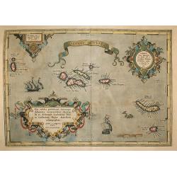
Açores Insulae.
The importance of the Azores at that time was connected with the observation of Columbus that compass variation (i.e. the difference between the real and the magnetic nor...
Date: Antwerp, 1592
Selling price: ????
Please login to see price!
Sold in 2009
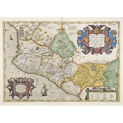
Hispaniae Novae.
This was the standard map of the area for a generation, copied by Quad and Hondius. Even though Herrera (Spain's Royal Cosmographer) and Wytfliet worked 20 years after Or...
Date: Antwerp, 1592
Selling price: ????
Please login to see price!
Sold in 2009
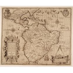
Americae Pars Magis Cognita. Chorographia nobilis & opulentae Peruanae Provinciae, atque Brasiliae, . . . MDXCII
Although a map of South America it does include much of what is now the southern United States. There are two elaborate, strap-work cartouches with the one at lower right...
Date: Frankfurt, 1592
Selling price: ????
Please login to see price!
Sold in 2014
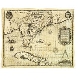
La Florida/ Peruviae Auriferae regionis Typus/ Guastecan.
The Chaves map of Florida is a prime example of an explorer's map since it records the recent discoveries of Cabeza de Vaca, De Soto, and Moscoso. The map revealed little...
Date: Antwerp, 1592
Selling price: ????
Please login to see price!
Sold in 2016
Acores Insulae.
Important map of Ortelius of the strategic islands of the Azores, in the 16th century an important hub from the Spanish Americas and the Silver fleet. The observation of ...
Date: Antwerp, 1592
Selling price: ????
Please login to see price!
Sold in 2018
![[South America] Delineatio omnium orarum totius Australis partis Americae..](/uploads/cache/16740-250x250.jpg)
[South America] Delineatio omnium orarum totius Australis partis Americae..
A particularly decorative example of Dutch cartography boasting two intricate strapwork cartouches. Exotic animals and bellicose indians populate the continent, while in ...
Date: Amsterdam 1593
Selling price: ????
Please login to see price!
Sold
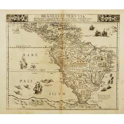
Brasilia et Peruvia.
A rare map of south America and the Caribbean with sea monsters and five sailing ships decorating the sea and small vignettes of natives, some with bow and arrow, others ...
Date: Antwerp 1593
Selling price: ????
Please login to see price!
Sold
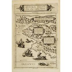
Quivirae Regnv cum alijs versus Borea.
Extraordinarily rare map, the first published map devoted to the west and north-west coasts of North America.The map not only conveys the early cartographic view of the N...
Date: Antwerp 1593
Selling price: ????
Please login to see price!
Sold
![[South America] Delineatio omnium orarum totius Australis partis Americae..](/uploads/cache/21304-250x250.jpg)
[South America] Delineatio omnium orarum totius Australis partis Americae..
A particularly decorative example of Dutch cartography boasting two intricate strapwork cartouches. Exotic animals and bellicose indians populate the continent, while in ...
Date: Amsterdam 1593
Selling price: ????
Please login to see price!
Sold
![[South America] Delineatio omnium orarum totius Australis partis Americae. . .](/uploads/cache/34876-250x250.jpg)
[South America] Delineatio omnium orarum totius Australis partis Americae. . .
A particularly decorative example of Dutch cartography boasting two intricate strapwork cartouches. Exotic animals and bellicose Indians populate the continent, while in ...
Date: Amsterdam, 1593
Selling price: ????
Please login to see price!
Sold in 2014
![[South America] Delineatio omnium orarum totius Australis partis Americae. . .](/uploads/cache/35162-250x250.jpg)
[South America] Delineatio omnium orarum totius Australis partis Americae. . .
A particularly decorative example of Dutch cartography boasting two intricate strapwork cartouches. Exotic animals and bellicose Indians populate the continent, while in ...
Date: Amsterdam, after 1593
Selling price: ????
Please login to see price!
Sold in 2017
![[South America] Delineatio omnium orarum totius Australis partis Americae. . .](/uploads/cache/94145-250x250.jpg)
[South America] Delineatio omnium orarum totius Australis partis Americae. . .
A particularly decorative example of Dutch cartography boasting two intricate strapwork cartouches. Exotic animals and bellicose Indians populate the continent, while in ...
Date: Amsterdam, after 1593
Selling price: ????
Please login to see price!
Sold in 2015
![[South America] Delineatio omnium orarum totius Australis partis Americae. . .](/uploads/cache/41496-250x250.jpg)
[South America] Delineatio omnium orarum totius Australis partis Americae. . .
A particularly decorative example of Dutch cartography boasting two intricate strapwork cartouches. Exotic animals and bellicose Indians populate the continent, while in ...
Date: Amsterdam, after 1593
Selling price: ????
Please login to see price!
Sold in 2019
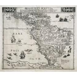
Brasilia et Peruvia.
VERY RARE. THE EARLIEST DUTCH MAP OF SOUTH AMERICA. A nice example of De Jode's important map of South America, based largely upon Petrus Plancius' wall map of the World....
Date: Antwerp, 1593
Selling price: ????
Please login to see price!
Sold in 2020
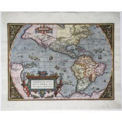
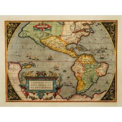
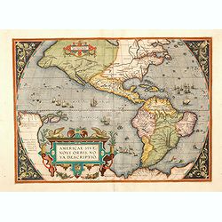
Americae sive Novi Orbis, Nova Descriptio.
An engraved map of the Americas, image 357 x 493 mm (452 x 550 mm sheet). Elaborate baroque title cartouche, may ships and sea-monster, Italian text on verso. One of the ...
Date: Antwerp, 1593
Selling price: ????
Please login to see price!
Sold in 2020
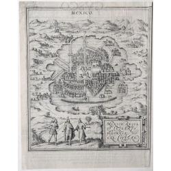
Mexico, Regia & Celebris Hispania Novae Civitas.
An old map with a bird's-eye view of Mexico City situated, as it was, in the middle of a lake, by Georg Braun and Frans Hogenberg, from the: 'Civitates Orbis Terrarum', K...
Date: Cologne, 1572-1593
Selling price: ????
Please login to see price!
Sold in 2020
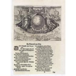
Americae Retectio (Allegory of the Discovery of America)
Allegorical scene commemorating the discovery of America. The main image shows Neptune, supporting a Globe, flanked by Flora-representing Florence, and Janus-representing...
Date: Frankfurt, 1594
Selling price: ????
Please login to see price!
Sold in 2015
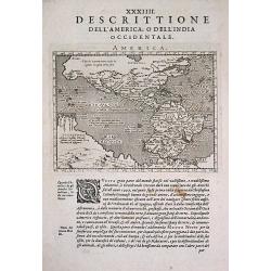
Occidentalis Americae partis.
The most beautifully engraved early map of the Caribbean, including Florida and the South-east. The map includes representations of Columbus' ships and various notes rega...
Date: Frankfurt, 1594
Selling price: ????
Please login to see price!
Sold
Occidentalis Americae partis..
The most beautifully engraved early map of the Caribbean, including Florida and the Southeast. The map includes representations of Columbus' ships and various notes regar...
Date: Frankfurt 1594
Selling price: ????
Please login to see price!
Sold in 2019
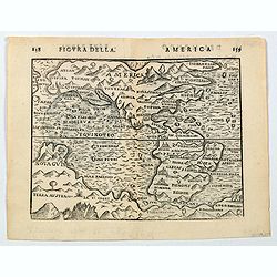
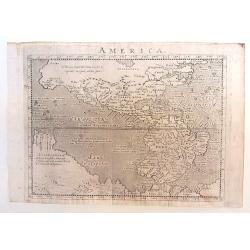
America.
A nice late 16th century, finely engraved map of America, published in Bologna in 1594 by Giuseppi Rossaccio. The map is interesting for the fact of its number of curious...
Date: Bologna, ca. 1594
Selling price: ????
Please login to see price!
Sold in 2020
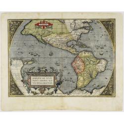
Americae sive novi orbis, nova descriptio.
In 1587, a new plate was engraved which appeared in editions from 1588 onwards. Of the three maps, this one is perhaps the most important. It is the most geographically a...
Date: Antwerp 1595
Selling price: ????
Please login to see price!
Sold
Maris Pacifici.
"This was the first printed map to be devoted solely to the Pacific, and the first to name North and South America separately. It includes most of North and South Am...
Date: Antwerp 1595
Selling price: ????
Please login to see price!
Sold
Hispaniae Novae.
This was the standard map of the area for a generation, copied by De Bry, Quad and Hondius. Even though Herrera (Spain's Royal Cosmographer) and Wytfliet worked 20 years ...
Date: Antwerp 1595
Selling price: ????
Please login to see price!
Sold
Americae sive novi orbis, nova descriptio.
In 1587, a new plate was engraved which appeared in editions from 1588 onwards. Of the three maps, this one is perhaps the most important. It is the most geographically a...
Date: Antwerp 1595
Selling price: ????
Please login to see price!
Sold
Americae sive novi orbis, nova descriptio.
In 1587, a new plate was engraved which appeared in editions from 1588 onwards. Of the three maps, this one is perhaps the most important. It is the most geographically a...
Date: Antwerp 1595
Selling price: ????
Please login to see price!
Sold
Maris Pacifici.
This was the first printed map to be devoted solely to the Pacific, and the first to name North and South America separately. It includes most of North and South America,...
Date: Antwerp 1595
Selling price: ????
Please login to see price!
Sold
Cusco
Miniature town view of the City of Cuzco, Peru, with figures in the foreground Valegio signature at the lower edge of the plate. It was published as part of a series of b...
Date: Venice, 1595
Selling price: ????
Please login to see price!
Sold in 2016
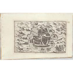
Mexico
Miniature map of Mexico city.
Date: Venice, 1595
Selling price: ????
Please login to see price!
Sold in 2014
Americae sive novi orbis, nova descriptio.
In 1587, a new plate was engraved which appeared in editions from 1588 onwards. Of the three maps, this one is perhaps the most important. It is the most geographically a...
Date: Antwerp, 1595
Selling price: ????
Please login to see price!
Sold in 2013
Americae sive novi orbis, nova descriptio.
In 1587, a new plate was engraved which appeared in editions from 1588 onwards. Of the three maps, this one is perhaps the most important. It is the most geographically a...
Date: Antwerp, 1595
Selling price: ????
Please login to see price!
Sold in 2014
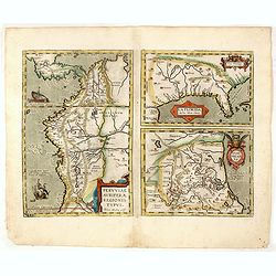
La Florida_Guastecan_Peruviae Avriferae Regionis Typus.
The most important map (La Florida) is the first printed map of the southeastern region of the United States. This influential map provided the foundation cartography for...
Date: 1595
Selling price: ????
Please login to see price!
Sold in 2017
Americae Sive Novi Orbis Nova Descriptio.
A beautiful colored map of the American continent which comes from the Latin edition of Theatrum Orbis Terrarum by Abraham Ortelius. This is the third plate that Ortelius...
Date: Antwerp, 1595
Selling price: ????
Please login to see price!
Sold in 2020
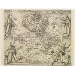
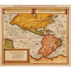
America sive novus orbis respectu Europaeorum inferior globi terrestris pars 1596.
An especially rare and beautiful hemisphere map of the Americas, with exquisite calligraphy and superb portraits of Columbus, Magellan, Vespucci and Pizarro adorning the ...
Date: Frankfurt 1596
Selling price: ????
Please login to see price!
Sold
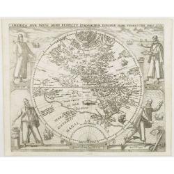
America sive novus orbis respectu Europaeorum inferior globi terrestris pars 1596.
An especially rare and beautiful hemisphere map of the Americas, with exquisite calligraphy and superb portraits of Columbus, Magellan, Vespucci and Pizarro adorning the ...
Date: Frankfurt, 1596
Selling price: ????
Please login to see price!
Sold
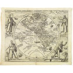
America sive novus orbis respectu Europaeorum inferior globi terrestris pars 1596.
An especially rare and beautiful hemisphere map of the Americas, with exquisite calligraphy and superb portraits of Columbus, Magellan, Vespucci and Pizarro adorning the ...
Date: Frankfurt, 1596
Selling price: ????
Please login to see price!
Sold in 2013
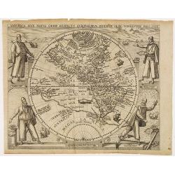
America sive novus orbis respectu Europaeorum inferior globi terrestris pars 1596.
An especially rare and beautiful hemisphere map of the Americas, with exquisite calligraphy and superb portraits of Columbus, Magellan, Vespucci and Pizarro adorning the ...
Date: Frankfurt, 1596
Selling price: ????
Please login to see price!
Sold in 2010
America sive novus orbis respectu Europaeorum inferior globi terrestris pars 1596.
An especially rare and beautiful hemisphere map of the Americas, with exquisite calligraphy and superb portraits of Columbus, Magellan, Vespucci and Pizarro adorning the ...
Date: Frankfurt, 1596
Selling price: ????
Please login to see price!
Sold in 2018
America.
Copper engraved map; overall size 14 x 20 cm by Giovanni Antonio Magini, from the: 'Geographiae Universae'. According to Burden, this is a reduced version of a map by d...
Date: Venice, 1596
Selling price: ????
Please login to see price!
Sold in 2015
Antique map of the Americas / America.
An Girolano Porro elegantly engraved map of the Americas, from Giovanni Antonio Magini's edition of Ptolemy's 'Geography', titled 'Geographia Universae'.
Date: Venice, 1596
Selling price: ????
Please login to see price!
Sold in 2017
Nova Reperta.
Title-page from a series of twenty prints illustrating new inventions and discoveries (Nova Reperta) after Jan van der Straet. Lettered on image: 'NOVA REPERTA,' on left ...
Date: Antwerp, 1596
Selling price: ????
Please login to see price!
Sold in 2018
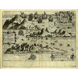
Vera effigies et delineatio Insulae, Ascencio nuncupatae (...) Waerachtighe affbeeldinghe en verthooninghe vant Eylant Asçençion (...)
A rare copper engraved bird's eye view by B. VAN DOETECUM of the island of Ascension in the South Atlantic Ocean. Panorama showing the island in three profile views, engr...
Date: Amsterdam, 1596
Selling price: ????
Please login to see price!
Sold in 2019
America.
A very attractive map of the American continent by Magini with a large area called ‘Nova Guinea’ and an uninterrupted coastline of the Arctic circle. This is a reduce...
Date: Venice, 1596
Selling price: ????
Please login to see price!
Sold in 2019
America.
A very attractive map. This is a reduced version of Giovanni d'Anian's 1582 Map of America.The geography is derived mainly from Ortelius' earlier map of the Western Hemis...
Date: Cologne 1597
Selling price: ????
Please login to see price!
Sold
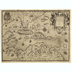
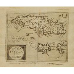
Cuba Insula et Jamaica.
One of only two Caribbean maps in this important work, which was one of the first atlases to provide detailed maps on the individual regions in the New World. The map is ...
Date: Louvain, 1597
Selling price: ????
Please login to see price!
Sold in 2012
Brasilia
A map of Brazil from "Descriptionis Ptolemaicae Augmentum, sive Occidentis Notitia" published in 1597. First edition, paper size 30 x 37 cm, map size: 28.4 cm x...
Date: 1597
Selling price: ????
Please login to see price!
Sold in 2016
(America)
An engraved map, consisting of the right hand part of a two sheet map of the Americas. Fausto Rughesi, a native of Montepulicano, is best known as Roman architect, his ma...
Date: Rome, c.1597
Selling price: ????
Please login to see price!
Sold in 2019
Insula D.Helenae sacra coeli..
A fine perspective view of the Island of St.Helena in the South Atlantic. The location of the Island directly on the navigation route from Europe to the Cape of Good Hope...
Date: Amsterdam 1598
Selling price: ????
Please login to see price!
Sold
Americae pars magis cognita.
Very early and RARE map of Central and South America by Theodore de Bry. In the third part of his Grand Voyages Theodore de Bry publishes the accounts of the voyages of J...
Date: Frankfurt 1598
Selling price: ????
Please login to see price!
Sold
Hispaniae Novae sive magnae,..
This was the standard map of the area for a generation, copied by De Bry, Quad and Hondius. Even though Herrera (Spain's Royal Cosmographer) and Wytfliet worked 20 years ...
Date: Antwerp, 1598
Selling price: ????
Please login to see price!
Sold
Americae Sive Novi Orbis, Nova Descriptio
Woodcut map by based on Abraham Ortelius' classic map of 1570, with the huge bulge in the southwest coastline of South America, the Ortelian western coastline of North Am...
Date: Basel 1598
Selling price: ????
Please login to see price!
Sold
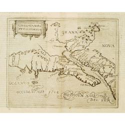
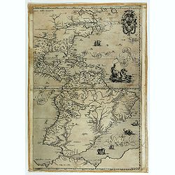
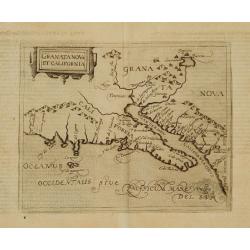
Granata Nova et California.
Very rare sixteenth century map: the second printed map devoted to the California peninsula and the south west of present day United States. A reduced version of the Corn...
Date: Cologne 1598
Selling price: ????
Please login to see price!
Sold
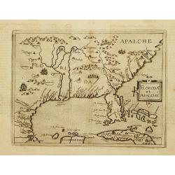
Florida et Apalche.
Very rare sixteenth century map: drawn from the Abraham Ortelius -Gerónimo de Chaves map entitled La Florida, published in 1584. However, here Metellus expands the area ...
Date: Cologne 1598
Selling price: ????
Please login to see price!
Sold
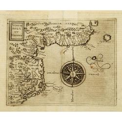
Norumbega et Virginia.
Rare sixteenth century map: It shows the east coast of North America from the Outer Banks of present day Carolina to Canada is depicted at a period just before a number o...
Date: Cologne 1598
Selling price: ????
Please login to see price!
Sold
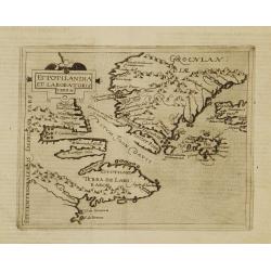
Estotilandia et Laboratoris terra.
This is an important and influential map depicting the first detailed record of the discoveries of Davis and Frobisher in their search for the Northwest Passage. The attr...
Date: Cologne 1598
Selling price: ????
Please login to see price!
Sold
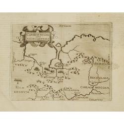
Conibas regio cum vicinis gentibus.
This is, however, the first printed map of present-day central Canada. The basic cartography derives from Gerard Mercator's world map of 1569, which first depicted a larg...
Date: Cologne 1598
Selling price: ????
Please login to see price!
Sold
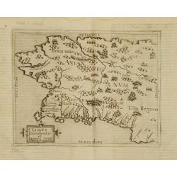
Limes occidentis et quiuira Anian.
Very rare sixteenth century map: One of the first printed map to focus on present day Alaska, here labeled "Anian Regnum." It encompasses most of the western co...
Date: Cologne 1598
Selling price: ????
Please login to see price!
Sold
Granata Nova et California.
Very rare sixteenth century map: the second printed map devoted to the California peninsula and the south west of present day United States. A reduced version of the Corn...
Date: Cologne 1598
Selling price: ????
Please login to see price!
Sold
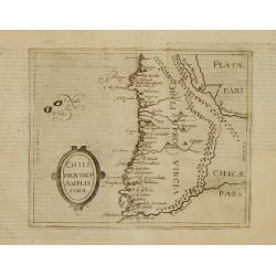
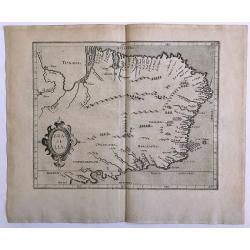
Chili Provincia Amplissima.
Very rare sixteenth century map of Chili.Published in the German edition of José de Acosta's De Natura Nova Orbis, first published in Salamanca, 1588. Acosta was a Spani...
Date: Cologne 1598
Selling price: ????
Please login to see price!
Sold
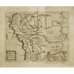
Peruani Regni Discriptio.
Very rare sixteenth century map of Peru.Published in the German edition of José de Acosta's De Natura Nova Orbis, first published in Salamanca, 1588. Acosta was a Spanis...
Date: Cologne 1598
Selling price: ????
Please login to see price!
Sold
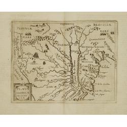
Plata Americae Provincia.
Very rare sixteenth century map showing part of Peru and the territory known as Paraguay including La Plata River and south part of Brazil, with effluents of Panama river...
Date: Cologne 1598
Selling price: ????
Please login to see price!
Sold
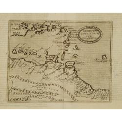
Residuum Continentis cum Adiacentibus Insulis.
Very rare sixteenth century map of Venezuela, including the islands of Curaçao, Bonaire, Aruba and the islands in the Caribbean and Puerto Rico.Published in the German e...
Date: Cologne 1598
Selling price: ????
Please login to see price!
Sold
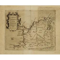
Castilia Aurifera cum vicinis Provinciis.
Very rare sixteenth century map of Colombia.Published in the German edition of José de Acosta's De Natura Nova Orbis, first published in Salamanca, 1588. Acosta was a Sp...
Date: Cologne 1598
Selling price: ????
Please login to see price!
Sold
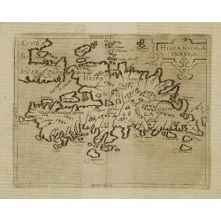
Hispaniola Insula.
Very rare sixteenth century map of the Hispaniola Island and the eastern tip of Cuba.Published in the German edition of José de Acosta's De Natura Nova Orbis, first publ...
Date: Cologne 1598
Selling price: ????
Please login to see price!
Sold
Cuba Insula et Iamaica.
Very rare sixteenth century map of Cuba, in lower part JamaicaPublished in the German edition of José de Acosta's De Natura Nova Orbis, first published in Salamanca, 158...
Date: Cologne 1598
Selling price: ????
Please login to see price!
Sold
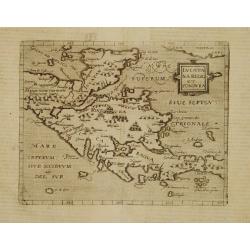
Iucatana Regio et Fondura.
Very rare sixteenth century map of Yucatan and Honduras.Published in the German edition of José de Acosta's De Natura Nova Orbis, first published in Salamanca, 1588. Aco...
Date: Cologne 1598
Selling price: ????
Please login to see price!
Sold