Browse Listings in Europe
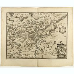
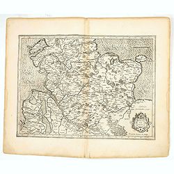
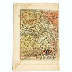
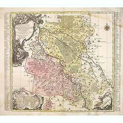
Namurcum Comitatus.
Prepared by Jacques Surhon in 1555. His manuscript map was, for security reasons not published. Only in 1579, when Antwerp was independent for a short time, Ortelius used...
Place & Date: Antwerp, 1598
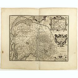
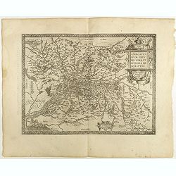
Brabantiae Descriptio.
In an inset Mechelen and surroundings. Decorative scale and title cartouche with dedicational initials, which may refer to Laurentius Michaelis, who may be connected with...
Place & Date: Antwerp, 1598
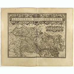
Leodiensis Diocesis Typus.
East to the top. Centered on Liege, including the southern part of Dutch Limburg. Prepared by Jan van Schille.Dare to go in Black. All early maps were printed in black an...
Place & Date: Antwerp, 1598
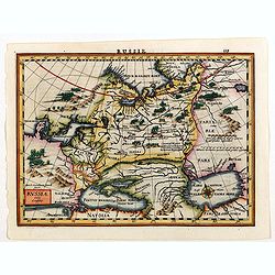
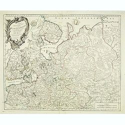
Russia.
Russia map from the rare Cloppenburg edition slightly larger format and more scarce edition of the Mercator/Hondius "Atlas Minor". Engraved by Pieter Van Den Ke...
Place & Date: Amsterdam, 1630
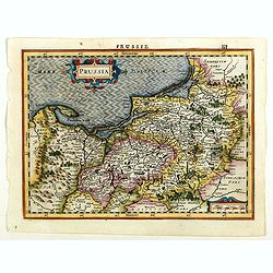
Prussia.
An attractive, detailed and early map of present-day Poland and Lithuania from the rare Cloppenburg edition slightly larger format and more scarce edition of the Mercator...
Place & Date: Amsterdam, 1630
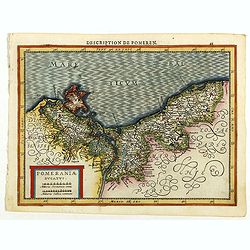
Pomeraniae Ducatus.
Pomerania map from the rare Cloppenburg edition slightly larger format and more scarce edition of the Mercator/Hondius "Atlas Minor". Small and detailed map of ...
Place & Date: Amsterdam, 1630

Vue perspective de la Galerie Royale de Copenhague conduisant au Jardin.
So-called optical print illustrating a perspective view of the Royal Portico in Copenhagen.Mondhare was a well-known publisher of optical prints, established in Paris. In...
Place & Date: Paris 1761
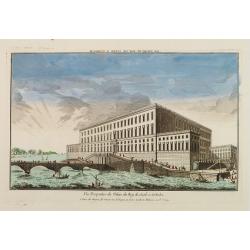
Vue Perspective du Palais du Roy de Suede a Stokolm.
Perspective view of The Stockholm Palace by Huquier, a well-known publisher of optical prints, established in Paris.In the eighteenth and nineteenth centuries there were ...
Place & Date: Paris 1760
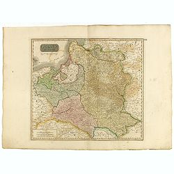
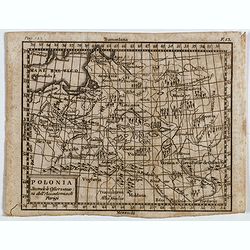
Poland As Divided.
This map covers Poland following Napoleonic Wars and the treaties of the 1815 Congress of Vienna.This map was first published in Thomson's New General Atlas of 1814. John...
Place & Date: Edinburgh, 1817
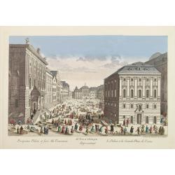
81e. Vue d'Optique Reprsentant Le Palais et la Grande Place de Vienne.
Optical print of a square in Vienna, by Daumont who was a well-known publisher of optical prints, established in Paris.In the eighteenth and nineteenth centuries there we...
Place & Date: Paris, 1760
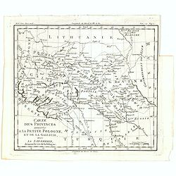
Carte des provinces annexées à la petite Pologne, et de la Gallicie, avec la Lodomerie, démembrées de la Pologne.
A map of the southern provinces of Poland by Louis Brion de la Tour, from the work "Histoire universelle depuis le commencement du monde jusqu a present" publis...
Place & Date: Paris, 1779

Gelriae, Cliviae, Finitimorumque Locorum Verissima..
East to the top. Fine map of Geldria and Limburg, prepared by Christian s'Grooten. Very fine title cartouche lower right with painter's utensils around the cartouche. ...
Place & Date: Antwerp, 1598
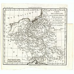
Carte de la Prusse, de la Grande et Petite Pologne, avec le démembrement des Palatinats de Cracovie et Sandomirz, faisant aujour d'hui partie de la Lodomerie.
A map of the Polish territories by Louis Brion de la Tour, from the work "Histoire universelle depuis le commencement du monde jusqu a present" published in Par...
Place & Date: Paris, 1779
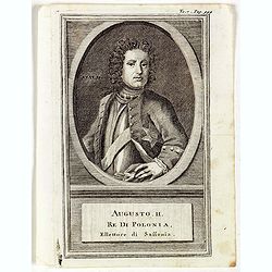
Augusti. II. Re di Polonia, Ellettore di Sassonia.
Portrait of Augustus II the Strong (12 May 1670 – 1 February 1733) of the Albertine line of the House of Wettin was Elector of Saxony (as Frederick Augustus I), Imperia...
Place & Date: Venice, 1739
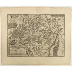
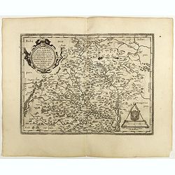
Lutzenburgen sis Ducatus Veriss. Descript.
An attractive map of Luxembourg: title cartouche on the lower left corner. From 'Theatrum Orbis Terrarum [Atlas of the Whole World]'.Iacobo Surhonio Montano auctore. D...
Place & Date: Antwerp, 1598
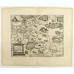
Anjou. Andegavensium Ditionis Vera et Integra Descriptio. Licimo Guijeto Andegavense auctore.
Beautiful map of the Anjou region of western France along the Loire River. Include the city of Angers in the center. Accompanying French text on verso. Dare to go in B...
Place & Date: Antwerp, 1598
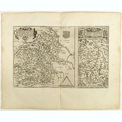
![Blaisois Blesiensis Territorii. . . [together with] - Lemovicum totius et confinium provinciarum. . .](/uploads/cache/40963-250x250.jpg)
Blaisois Blesiensis Territorii. . . [together with] - Lemovicum totius et confinium provinciarum. . .
The map on the left is centered on the Loire with the town of Blois. The right-hand map is centered on Limoges. Dare to go in Black. All early maps were printed in bla...
Place & Date: Antwerp, 1598
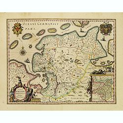
Typus Frisiae Orientalis.
Finely engraved map of east Frisia in Germany with the Watten islands. With inset map of the area south of Emden. Prepared by Ubbo Emmius (1547-1625). A very decorative t...
Place & Date: Amsterdam, 1635
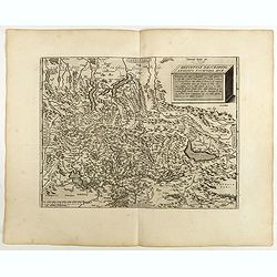
Regionis Biturigum... Per Ioannem Calamaeum. / Limaniae Topographia Gabriele Symeoneo Auct.
Two maps on one sheet. Biturigum. The Loire river is on the right in central France. Neuers (Nevers) is at the middle of the right margin. Bourges is near the center, and...
Place & Date: Antwerp, 1598
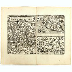
Carinthiae et Goritiae .. / Histria / Zarae / Serebenici. . .
Three maps on one sheet. The left hand is centered on the eastern part of Austria. The right upper hand map is centered on northern Yugoslavia, and the last map is center...
Place & Date: Antwerp, 1598
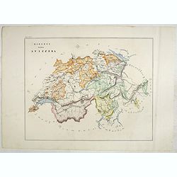
Helvetiae Descriptio . . .
A fine map based upon a map by the Swiss cartographer Aegidicus Tschudi of 1538.Dare to go in Black. All early maps are printed in black and white and many were kept that...
Place & Date: Antwerp, 1598

Silesiae typus..
Fine and early map of Silesia after Martin Helwig (1516-1574) and used by A.Ortelius in his atlas 'Theatrum Orbis Terrarum [Atlas of the Whole World].Only included in the...
Place & Date: Antwerp, 1598
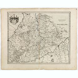
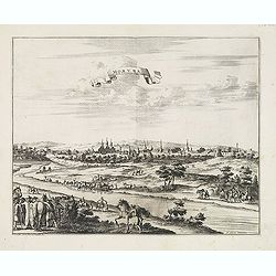
Moraviae.
This early map of Slovakia was prepared by Paul Fabritius in 1569, centered on the city of Brno. Title cartouche on the upper left corner. Abraham Ortelius (1527-1598) wa...
Place & Date: Antwerp, 1598
Russiae, Moscoviae et Tartariae Descriptio.
Engraved by Frans Hogenberg from an original of 1562 by Anthony Jenkinson of the English Muscovy Company. The many vignettes are based on the reports of Marco Polo's expl...
Place & Date: Antwerp, 1598

Romaniae, (quae olim Thracia dicta) ..
Very fine map centered on the Danube area. The map is based on the double sheet map by Jacob Gastaldi. Abraham Ortelius (1527-1598) was a cartographer and publisher, who ...
Place & Date: Antwerp, 1598

Hollandiae Antiquorum Catthorum..
This map shows Holland in great detail, including small towns, walled cities, rivers and lakes (many of which were reclaimed in the 17th century, and no longer exist). A ...
Place & Date: Antwerp, 1598
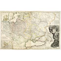
To His Most Serene and August Majesty Peter Alexovitz Absolute Lord of Russia &c. This map of Moscovy, Poland, Little Tartary, and ye Black Sea &c. is most Humbly Dedicated by H. Moll Geographer
Magnificent large-scale, English map of Russia, Ukraine, Poland, Finland and the Baltic Countries and extending south to the Black Sea and the Balkans, with an ornate ded...
- $1500 / ≈ €1404
Place & Date: London, 1716
Ducati di Livonia e di Estonia, e Governi di Nowogorod...
Shows today's Estonia, and the governorates Nowgorod, Bialgorod and Kiew in today's Russia, Belarus and Ukraine.
- $175 / ≈ €164
Place & Date: Venise, 1782
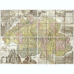
Nova Helvetiae tabula geographica . . .
Johann Jakob Scheuchzer (August 2, 1672 – June 23, 1733) was a Swiss scholar born at Zürich. In 1712 he published, a map of Switzerland in four sheets (scale 1/290,000...
- $1750 / ≈ €1638
Place & Date: Amsterdam, 1712
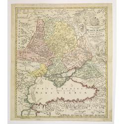
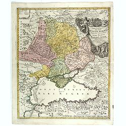
Tabula Geographica qua pars Russiae Magnae. . .
U unrecorded state Homann's map is based upon the works of George von Mengden (1628-1702), a Livonian cartographer who worked for Peter the Great and Count Jacob Bruce [G...
- $1000 / ≈ €936
Place & Date: Nuremberg, c. 1770
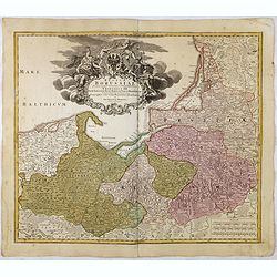
Regnum Borussiae gloriosis auspicijs Seerenissimi et Potentissimi Princip Friderici III Primi . . .
Map covering the region along the Baltic Sea from Prussia, Memel, to northern Poland, extending south to Poland, centered on Danzig, Konigsberg, Heilsperg, etc. Beautiful...
- $350 / ≈ €328
Place & Date: Nuremberg, 1720

Carte De La Prusse Occidentale ou sont tracees les Provinces cedees Par la Pologne au Roi De Prusse . . . 1775
Finely and crisply engraved map of Western Prussia, now part of Poland on the Baltic Sea, including the Bay of Danzig. With ornamental title cartouche and noteworthy topo...
- $250 / ≈ €234
Place & Date: Venice, 1776 - 1784
Wirtenberg Ducatus.
FIRST EDITION, FIRST ISSUE OF THIS MAP. From the 1634 edition of Blaeu's Atlas Novus, the first edition of this work. PROOF STATE with blank upper right corner, only incl...
- $100 / ≈ €94
Place & Date: Amsterdam, 1634
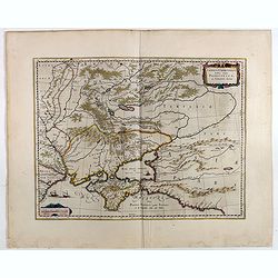
Tabula Geographica qua pars Russiae Magnae. . .
Homann's map is based upon Beauplan's general map of Ukraine but depicts the political changes of the preceding years. With decorative cartouches. Giving good detail alon...
- $680 / ≈ €636
Place & Date: Nuremberg, 1720
Taurica Chersonesus, Nostra aetate Prezecopsca, et Gazara dicitur.
Part of Russia with in the north Smolensk and including Moscow and in the south the Black Sea.More about Willem Blaeu. [+]Taurica, Tauric Chersonese, and Taurida were nam...
- $500 / ≈ €468
Place & Date: Amsterdam, 1645
Polonia secondo le obzervazioni dell'accademiadi Parigi.
Uncommon Italian map of present day Poland and Lithuania prepared by Claude Buffier was a Jesuit theologian and geographer working in Paris, who wrote the Geographie Univ...
- $150 / ≈ €140
Place & Date: Naples, Rome, ca. 1725
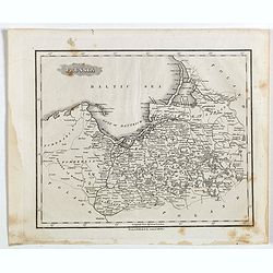
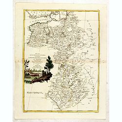
Part of Prussia.
Attractive example of the scarce 1828 Malte-Brun map of modern day Poland and Lithuania. Published by Samuel Walker in 1828 as part of the American edition of Conrad Malt...
- $100 / ≈ €94
Place & Date: Boston, 1828
Kom - Kaschan.
An early of Kom and Kaschan on one sheet. From the rare first edition "Offt begehrte Beschreibung der newen orientalischen Rejse, so durch Gelegenheit einer Holstei...
- $250 / ≈ €234
Place & Date: Schleßwig, Zur Glocken, 1647
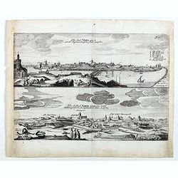
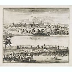
Die stadt Narva . . .
Two panoramic views of the city of Narva, on one sheet. Narva is the third largest city in Estonia. It is located at the eastern extreme point of Estonia, at the Russian...
- $250 / ≈ €234
Place & Date: Schleßwig, Zur Glocken, 1647
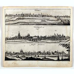
Colomna - Cassimogorod - Moruma.
Three panoramic views of Colomna - Cassimogorod - Moruma on one sheet. From the rare first edition "Offt begehrte Beschreibung der newen orientalischen Rejse, so dur...
- $300 / ≈ €281
Place & Date: Schleßwig, Zur Glocken, 1647
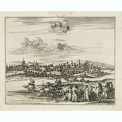
Tarku.
An early of Tarku in the Republic of Dagestan. From the rare first edition "Offt begehrte Beschreibung der newen orientalischen Rejse, so durch Gelegenheit einer Ho...
- $250 / ≈ €234
Place & Date: Schleßwig, Zur Glocken, 1647
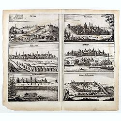
Tetus - Samara - Soratof - Zariza - Tzornogar - Kusmamedianski.
Panoramic views of Tetus, Samara, Soratof, Zariza, Tzornogar and Kusmamedianski on one sheet. From the rare first edition "Offt begehrte Beschreibung der newen orien...
- $300 / ≈ €281
Place & Date: Schleßwig, Zur Glocken, 1647
![[John Smith caught by the French.]](/uploads/cache/40473-250x250.jpg)
[John Smith caught by the French.]
In 1615, during one of John Smith’s voyages across the Atlantic, he was caught by some French pirates. While at sea in captivity he was forced to suffer great hardships...
- $75 / ≈ €70
Place & Date: Frankfurt, M.Merian, 1633

Pas-Caart van de ZUYDER-ZEE, Texel ende Vlie-stroom.als mede 't Amelander gat (Hollandt/Vrieslandt)
An attractive chart of the Zuiderzee, now the inland water het IJselmeer.HOLLANDT / VRIESLANDTPas-Caart van de Zuyder-Zee, Texel ende Vlie-stroom.als mede 't Amelander g...
- $1200 / ≈ €1123
Place & Date: Amsterdam, c. 1665
La Mayerie de BOLDVC,. . .
From his atlas Oorlogs tablessen, Oft uytgesochte Kaarten . Covering the so-called area Meierij van 's-Hertogenbosch . Eindhoven in the centre of the map.
- $150 / ≈ €140
Place & Date: Amsterdam, 1706
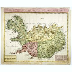
Insulae Islandiae delineatio : prout haec Solenni mensurandi negotio sub Auspiciis Potensissimi Regis Daniae facto . . .
Detailed and important map of Iceland, prepared by Th. H. Knoff and O. Ranzow and published by the Homann Heirs. The map is more scientific than many previous similar ver...
- $850 / ≈ €795
Place & Date: Nuremberg, 1761
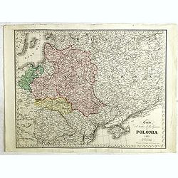
Carta del Teatro della Guerra in Polonia - 1831.
Oversized rare 1831 war map of Poland and Lithuania published during the Polish - Russian War in 1831, published by Presso l'incisore Stanislao Stucchi. Stucchi, was born...
- $900 / ≈ €842
Place & Date: Milan, 1831
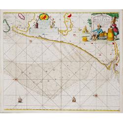
Nieuwe Paskaert van de Kust van HOLLANDT - Tussen Texel en de Maes.
Nieuwe Paskaert van de Kust van Hollandt Tussen Texel en de Maes. A very attractive sea chart off the coast of Holland by Johannes van Keulen with a pair of decorative c...
- $500 / ≈ €468
Place & Date: Amsterdam, ca 1685
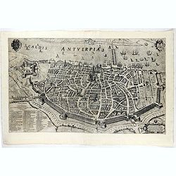
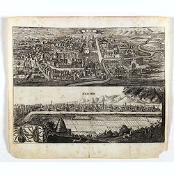
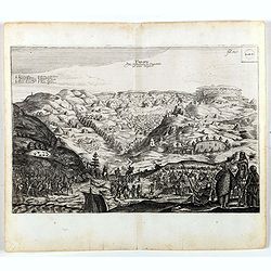
Scaldis Antverpia - Locorum Insignium ac viae triumphalis qua ser.mus princeps, Ferdinandus Austriacus, Hispaniar, Infans. etc. Antverpiam est ingressus, designatio . . .
Bird's-eye view of the city of Antwerp and the River Schelde, numbered (1-59 ) with important sites along the entry of the Cardinal Infant Ferdinand of Austria into Antwe...
- $2000 / ≈ €1871
Place & Date: Antwerp, 1635-1641
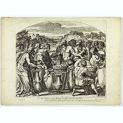
Cataractae coeli apertoe funt: Et aguae proealuerunt super terram comfumptag Est omnis caro . . . (Plate 13)
Very nice etching by Nicolas Chapron, and after Raphaël's (Raffaello Sanzio) frescoes in the Vatican Loggia. Scene illustrating the moment when God said to Noah "Go...
- $25 / ≈ €23
Place & Date: Paris, Petrus Mariette, 1649
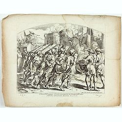
Arca Dni septies circuit Ciuitatem et clangentib tubis. Jericho corruerunt Moenia. Iosue. CVI. ( Plate 38)
Very nice etching by Nicolas Chapron, after Raphaël's (Raffaello Sanzio) frescoes in the Vatican Loggia. Scene illustrating the walls of Jericho crumbling.From the first...
- $25 / ≈ €23
Place & Date: Paris, Petrus Mariette, 1649
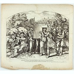
Portantes Arcam sacerdotes . . . (Plate 37)
Very nice etching by Nicolas Chapron, after Raphaël's (Raffaello Sanzio) frescoes in the Vatican Loggia. Scene illustrating Priests carrying the Ark through the River Jo...
- $25 / ≈ €23
Place & Date: Paris, Petrus Mariette, 1649
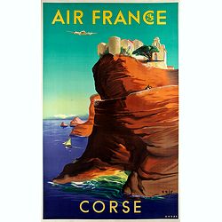
Air France - Corse.
Corsica poster for Air France, by Raoul Éric Castel (1915 - 1997) and published by Havas. Signed has work with Éric, he was born in Lyon and made many fine travel poste...
- $1200 / ≈ €1123
Place & Date: Imprimerie Perceval Paris, ca. 1940-1950
![Terta Etas Mundi. Foliu CX [With view of Metz]](/uploads/cache/46260-250x250.jpg)
Terta Etas Mundi. Foliu CX [With view of Metz]
The Latin text page is illustrated with a depictions of Kings, Noble men and women and scientists, among Eustace (Eustachius) a Roman soldier and martyr, appears as a bea...
- $450 / ≈ €421
Place & Date: Nuremberg, 12 July 1493
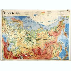
U.S.S.R. Carte Agricole. / U.S.S.R. Carte Industries et communications.
An unusual school map with on one side an agricultural map of Russia on verso a map of Russia showing communication an according to population. Prepared by Pierre Serryn ...
- $200 / ≈ €187
Place & Date: St-Germain-en-Laye, 1965
Holsatia ducatus.
Map of Holsatia. Including the town of Hamburg.Mercator was born in Rupelmonde in Flanders and studied in Louvain under Gemma Frisius, Dutch writer, astronomer and mathem...
- $150 / ≈ €140
Place & Date: Amsterdam, 1606
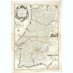
Le Portugal dedié au Roy.
Detailed over-sized map of Portugal prepared by P. Placide Augustin, with fine title cartouche. Engraved by Inselin.Le Père Placide de Sainte-Hélène was the brother-in...
- $400 / ≈ €374
Place & Date: Paris, ca. 1700
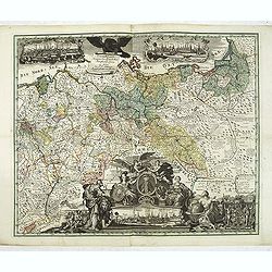
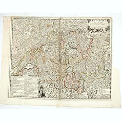
Generale Carte der gesamten Koniglichen Preussischen Lander. . .
Beautiful and rare two-sheet map of Prussia with part of now-a-days Poland. The title cartouche is hold by a crowned eagle. In lower part a large baroque cartouche with a...
- $3000 / ≈ €2807
Place & Date: Berlin, 1760
Partie Septentrionale de la Russie Europeenne ou sont distinguees exactement toutes les Provinces, d'apres le detail de l'Atlas Russien, Par le Sr. Robert de Vaugondy fils, Geog. Ordin? Du Roi.
Detailed map of northern European Russia, including Finland. The map was first published by the Venetian cartographer and publisher François (Père) Santini and first pu...
- $400 / ≈ €374
Place & Date: Venice, 1784
Moscovie dite autrement Grande et Blanche Russie.
Uncommon map of the Russia, including Finland, here with the date 1686.
- $500 / ≈ €468
Place & Date: Paris, 1686
Les Suisses leurs sujets et leurs alliez. . .
Un uncommon map of Switzerland by Nolin.
- $250 / ≈ €234
Place & Date: Paris, ca. 1760
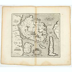
Fionia.
Early map, including Odense and the island Langeland .
- $200 / ≈ €187
Place & Date: Amsterdam, 1630
Basiliensis territorii descriptio nova.
Left hand map centered on Basle, east to top. With credit to Sebastian Münster in title cartouche.
- $200 / ≈ €187
Place & Date: Antwerp, 1573
Diocesi della Svizzera (Tav IV)
This large-format Switzerland map is finely engraved and beautifully colored and was prepared by Girolamo Petri, a lawyer who served as a senior official within the Vatic...
- $750 / ≈ €702
Place & Date: Rome, 1858
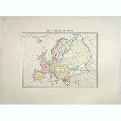
Carta generale di Europa (Tav IV)
This large-format Europe map is finely engraved and beautifully colored and was prepared by Girolamo Petri, a lawyer who served as a senior official within the Vatican’...
- $750 / ≈ €702
Place & Date: Rome, 1858
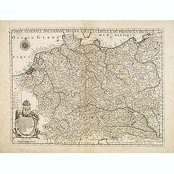
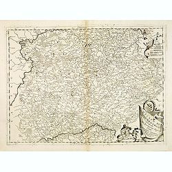
Carte générale d'Alemagne divisée par les cercles ou provinces d'icelle.
Rare and detailed map of Germany, Poland and Austria, engraved by H. le Roy in 1643 or 1666 for Jacques L'Agniet. The publishing house Jollain bought the copper plate and...
- $300 / ≈ €281
Place & Date: Paris, 1666
Electoratus saxonici praefecturae annaburgensis pretzschens torgaviensis schweinicensis. . .
Highly detailed map showing the regions of Annaburg, Pretzsch, Schweinitz in Sachsen-Anhalt, Torgau in Sachen and Mühlberg an der Elbe in Brandenburg. In the center of t...
- $60 / ≈ €56
Place & Date: Augsburg, 1750
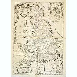
Parte settentrionale del regno d'inghilterra. . ./ Parte meridioçnale des regno d'inghilterra. . .
A beautiful and flamboyantly engraved two sheet map of British Isles, including four large cartouches and table of counties, towns, etc. Shows towns, mountains, rivers, l...
- $500 / ≈ €468
Place & Date: Venice, 1698
Ducato di Luxembourgo . . .
A beautiful and flamboyantly engraved map of Luxembourg. The map is the product of the late 17th century Venetian cartographer, Vincenzo Coronelli. A decorative title car...
- $200 / ≈ €187
Place & Date: Venice, 1698
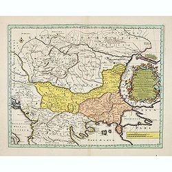
Illyricum Orientis In quo Partes II. Moesia et Thracia. Provinciae XI.
Attractive historical map of the area west of the Black Sea, today's Bulgaria, Rumania, etc. Based on the cartography of Nicolas Sanson and published by Covens and Mortie...
- $400 / ≈ €374
Place & Date: Amsterdam, c. 1720
Soratof, ville de Tartarie Moscovite. / Tzornogar, Petite Ville des Moscovites, dans le Royaume d'Astracan, sur le bord du Volga.
Decorative engraving of two panoramic views in top Saratov with in the foreground the Volga River and in bottom a view of Chernyy Yar on the Volga River. This well execut...
- $300 / ≈ €281
Place & Date: Leiden, 1719-1727
Cassimogorod ville de la Tartarie Moscovite.
Decorative view of the town of Kasimov on the Oka River, east from Moscow and south from Murom near the northern shore of the Caspian Sea. The city is seen from across th...
- $300 / ≈ €281
Place & Date: Leiden, 1719-1727
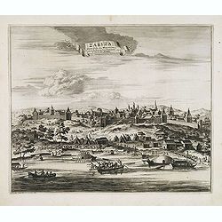
Zariza, petite ville des Moscovites, dans le royaume d'astracan, sur le bord du Wolga.
Decorative view of the town of Volgograd (Zarizyn) on the Volga River. This well executed engraving was published in 1729 and 1727 by Pieter van der AA, in Leiden in &quo...
- $300 / ≈ €281
Place & Date: Leiden, 1719-1727
Moruma ville de la Tartarie Moscovite.
Decorative view of the town of Moruma, Russian city near the northern shore of the Caspian sea as seen from across the river Oka. This well executed engraving was publish...
- $300 / ≈ €281
Place & Date: Leiden, 1719-1727
![Partie septentrionale du cercle de Haute Saxe [...] Brandebourg.](/uploads/cache/33211-250x250.jpg)
Partie septentrionale du cercle de Haute Saxe [...] Brandebourg.
Finely and crisply engraved map of north eastern part of Germany, including part of Poland. With inset map of Brandenburg. Map by Giles Didier Robert De Vaugondy with era...
- $150 / ≈ €140
Place & Date: Paris, c. 1760
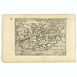
Caletensium et Bononiesium def.
An decorative miniature map of the N.W. France, including Calais and Boulogne. A map full of detail and attractive embelishments. North is orientated to the left. From th...
- $100 / ≈ €94
Place & Date: Amsterdam, 1606
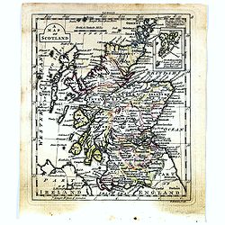
A map of Scotland.
Uncommon miniature map of Scotland, engraved by Thomas Kitching for "A New General and Universal Atlas Containing Forty five Maps by Andrew Dury".This miniature...
- $50 / ≈ €47
Place & Date: London, 1761-1763
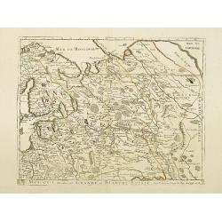
Typus Generalis Ukrainae sive Palatinatuum Podoliae, Kioviensis et Braczlaviensis terras nova delineatione exhibens. . .
A key map engraved by Johannes Janssonius in about 1656 and based on Guillaume La Vasseur de Beauplan's map of the region published in "Description d'Ukraine". ...
- $2000 / ≈ €1871
Place & Date: Amsterdam, ca. 1657
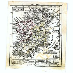
Ireland.
Uncommon miniature map of Ireland, engraved by J. Bayly for "A New General and Universal Atlas Containing Forty five Maps by Andrew Dury".This miniature atlas p...
- $50 / ≈ €47
Place & Date: London, 1761-1763
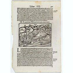
De Lucerna Helvetiorum Civitate. (Luzern)
One Latin text page with a wood cut bird's-eye view of Luzern (147x157mm). From Münster's Cosmographia Universalis. The Cosmographia by Sebastian Münster from 1544 is t...
- $50 / ≈ €47
Place & Date: Basle, ca. 1564