Browse Listings in Europe
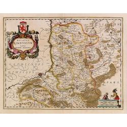
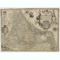
Ducatus Limburg.
In 1616 prepared by Aegidio Martini. Includes the towns of Maastricht as well as of Aachen. A very large title cartouche with two putti.
Place & Date: Amsterdam 1639
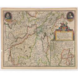
De Hertochdommen Gulick Cleve Berghe en de Graefschappen...
It is one of Blaeu's early maps: It was only published between 1630 and 1635 in three editions of the "Appendix" and one of the "Theatrum". In the lef...
Place & Date: Amsterdam, 1635
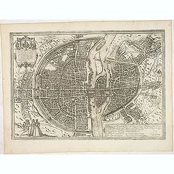
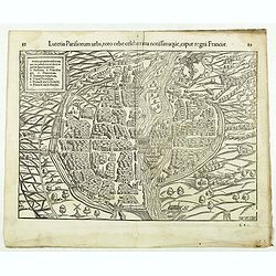
Lutetia, vulgari nomine Paris, urbs Gallia. . .
Beautiful and early town-plan of Paris with title cartouche and figures in the foreground. The Bastille is shown at the upper center of the engraving and the Notre-Dame c...
Place & Date: Cologne, ca. 1572
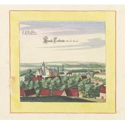
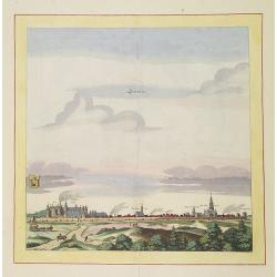
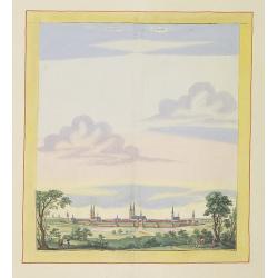
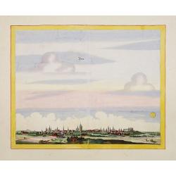
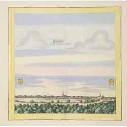
Haus trebnits an der saale.
Very decorative and rare panoramic of Trebnitz a.d Saale , Bez. Halle.The engraver and publisher of prints, Mrs. Anna Beek of the Hague, enlarged the print and mounted i...
Place & Date: The Hague, ca. 1642
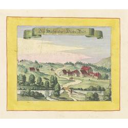
Das Wiesen oder Hiobs Badt.
Very decorative and rare panoramic town view of Wiensenbad near Annaberg im Erzgebirge.The engraver and publisher of prints, Mrs. Anna Beek of the Hague, enlarged the pri...
Place & Date: The Hague, ca. 1642
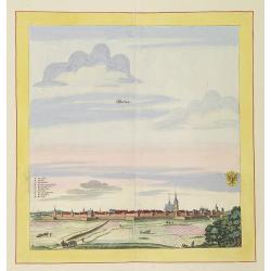
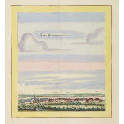
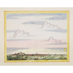
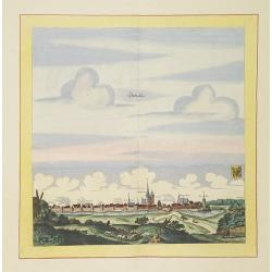
Weissensee.
Very decorative and rare panoramic town view of Weissensee in Thürigen, Bez. Erfurt.The engraver and publisher of prints, Mrs. Anna Beek of the Hague, enlarged the print...
Place & Date: The Hague, ca. 1642
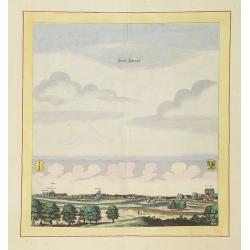
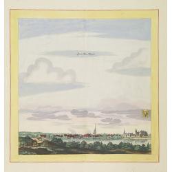
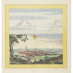
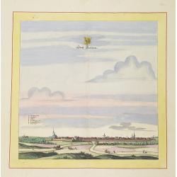
Hertzberg.
Very decorative and rare panoramic town view of Herzberg a.d. Schwarzen Elster, Bez. Cootbus.The engraver and publisher of prints, Mrs. Anna Beek of the Hague, enlarged t...
Place & Date: The Hague, ca. 1642
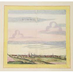
Newstatt an der Orla.
Very decorative and rare panoramic of Neustadt a.d. Donau, Kr. Kelheim, Ndb.The engraver and publisher of prints, Mrs. Anna Beek of the Hague, enlarged the print and mou...
Place & Date: The Hague, ca. 1642

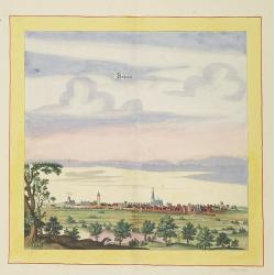
Greüssen.
Very decorative and rare panoramic town view of Greussen (Thür.),Bez. Erfurt .The engraver and publisher of prints, Mrs. Anna Beek of the Hague, enlarged the print and m...
Place & Date: The Hague, ca. 1642
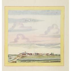
Schweet.
Very decorative and rare panoramic town view of Schwedt a.d Oder, Bez. Frankfurt a.d. Oder.The engraver and publisher of prints, Mrs. Anna Beek of the Hague, enlarged the...
Place & Date: The Hague, ca. 1642
Werben.
Very decorative and rare panoramic town view of Werben a.d. Elbe, Bez. Magdeburg.The engraver and publisher of prints, Mrs. Anna Beek of the Hague, enlarged the print and...
Place & Date: The Hague, ca. 1642
Bützom.
Very decorative and rare panoramic town view of Bützom.The engraver and publisher of prints, Mrs. Anna Beek of the Hague, enlarged the print and mounted it on larger pap...
Place & Date: The Hague, ca. 1642
Statt und Ambtt Wantzleben.
Very decorative and rare panoramic town view of Wanzleben, Bez. Magdeburg.The engraver and publisher of prints, Mrs. Anna Beek of the Hague, enlarged the print and mounte...
Place & Date: The Hague, ca. 1642
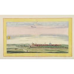
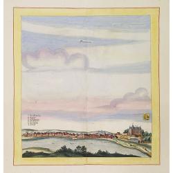
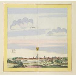
Stendalia Stendel
Very decorative and rare panoramic town view of Stendal, Bez. Magdeburg.The engraver and publisher of prints, Mrs. Anna Beek of the Hague, enlarged the print and mounted ...
Place & Date: The Hague, ca. 1700
Gloster Brüningen bei Halberstatt.
Very decorative and rare panoramic town view of Halberstatt.The engraver and publisher of prints, Mrs. Anna Beek of the Hague, enlarged the print and mounted it on larger...
Place & Date: The Hague, ca. 1700
Stättl Zedenick.
Very decorative and rare panoramic town view of Zedenick a.d. Havel, Bez. potsdam.The engraver and publisher of prints, Mrs. Anna Beek of the Hague, enlarged the print an...
Place & Date: The Hague, ca. 1700
Newenwedel.
Very decorative and rare panoramic town view of Newenwedel i.d. Neumark .The engraver and publisher of prints, Mrs. Anna Beek of the Hague, enlarged the print and mounted...
Place & Date: The Hague, ca. 1700
Zerbst.
Very decorative and rare panoramic town view of Zerbst in Bez, Magdeburg.The engraver and publisher of prints, Mrs. Anna Beek of the Hague, enlarged the print and mounted...
Place & Date: The Hague, ca. 1700
Eilenburg.
Very decorative and rare panoramic view of Eilenburg a.d. Mulde.The engraver and publisher of prints, Mrs. Anna Beek of the Hague, enlarged the print and mounted it on la...
Place & Date: The Hague, ca. 1700
Statt Alten Rüppin.
Very decorative and rare panoramic town-view of Statt Alten Rüppin.The engraver and publisher of prints, Mrs. Anna Beek of the Hague, enlarged the print and mounted it o...
Place & Date: The Hague, ca. 1700
Stättlein Frohsa.
Very decorative and rare panoramic town view of Frohse a.d. Elbe, Bez. Magdeburg.The engraver and publisher of prints, Mrs. Anna Beek of the Hague, enlarged the print and...
Place & Date: The Hague, ca. 1700
Laûn.
Very decorative and rare panoramic of Laun Louny a.d. Eger Böhmen.The engraver and publisher of prints, Mrs. Anna Beek of the Hague, enlarged the print and mounted it o...
Place & Date: The Hague, ca. 1700
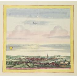
Döblen.
Very decorative and rare panoramic of Döblen in Sachsen.The engraver and publisher of prints, Mrs. Anna Beek of the Hague, enlarged the print and mounted it on larger p...
Place & Date: The Hague, ca. 1700
Stättlein Saltza.
Very decorative and rare panoramic town view of Salzelmen Bad Salzemen, Bez. Magdeburg. The engraver and publisher of prints, Mrs. Anna Beek of the Hague, enlarged the pr...
Place & Date: The Hague, ca. 1700
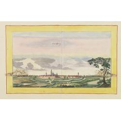
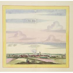
Seehaüsen.
Very decorative and rare panoramic of Seehausen, Altmark, Bez. Magdeburg .The engraver and publisher of prints, Mrs. Anna Beek of the Hague, enlarged the print and mount...
Place & Date: The Hague, ca. 1700
Calvorde.
Very decorative and rare panoramic of Calvörde, Bez. Magdeburg.The engraver and publisher of prints, Mrs. Anna Beek of the Hague, enlarged the print and mounted it on l...
Place & Date: The Hague, ca. 1700
Templin
Very decorative and rare panoramic town view of Templin in Uckermark.The engraver and publisher of prints, Mrs. Anna Beek of the Hague, enlarged the print and mounted it ...
Place & Date: The Hague, ca. 1700
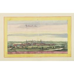
Statt Garleben.
Very decorative and rare panoramic town view of Gardelegen in Altmark.The engraver and publisher of prints, Mrs. Anna Beek of the Hague, enlarged the print and mounted it...
Place & Date: The Hague, ca. 1700
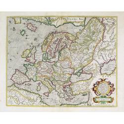
Europa, ad magnae Europae Gerardi Mercatoris. . .
General map of Europe with in the left hand corner, south east of Iceland the mythical island of Frisland, which was purportedly discovered by the Zeno brothers in a 14th...
Place & Date: Amsterdam, 1628
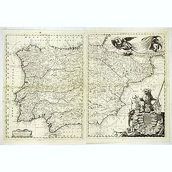
Parte Orientale della Spagna. . .
A scarce and very attractive double sheet detailed map of Spain and Portugal. This map appeared in the "Atlante Veneto", Coronelli's best known work. In a typic...
Place & Date: Venice, 1696

Plan de Paris commencé l'année 1734, Dessiné et gravé sous les ordres de Messire Michel Etienne Turgot, prévost des marchands.
FIRST EDITION of Turgot's Monumental Joined View of Paris, stretching to over 10 Feet.This expansive engraved view of Paris covers the first eleven arrondissements of mod...
Place & Date: Paris, 1739
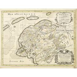
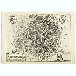
La seigneurie d'ouest-Frise ou Frise Occidentale
Fine map of the Friesland with a decorative title and scale cartouche.Alexis-Hubert Jaillot (1632-1712), was a French cartographer. He joined the Sanson heirs and redrew ...
Place & Date: Amsterdam, 1692
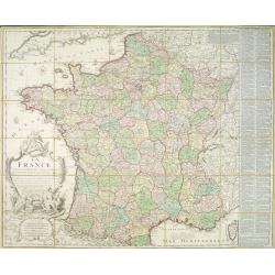
La France divisée en 83 départemens suivant les décréts de l'Assemblée Nationale, sanctionnés per le Roi. . .
An interesting folding map of France divided in 83 departments, to the right the 83 departments added on past-on slips. Another past-on is advertising Desnos' atlas in la...
Place & Date: Paris, 1790
![Groeninga MDLXXIII. [Groningen]](/uploads/cache/27192-250x250.jpg)
Groeninga MDLXXIII. [Groningen]
RECTO: A panoramic view of the city of Groningen dated 1573.VERSO: a woodcut of a cow, a bull and their calf.Taken from Sebastian Munster's encyclopedic work, the "C...
Place & Date: Basle, ca. 1564
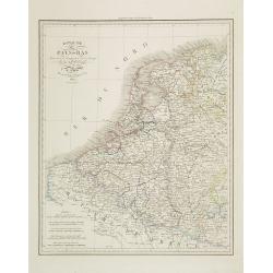
Royaume des Pays-Bas . . .
Detailed map of the Netherlands, Belgium and Luxembourg, prepared by A. H. Basset, rue Saint-Jacques, no. 64, Paris and published in Atlas classique et Universel de Géog...
Place & Date: Paris, A.H. Basset, 1828
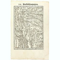
VIII. Das Wiflispurgergow.
Very early wood cut printed regional map of Switzerland with Lake Geneva.Originally engraved in 1548. The map was prepared by Johannes Stumpf (1500-1576). Included in &qu...
Place & Date: Zurich, Christoffel Froschover, 1548,1552-1566
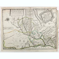
Carte du siège présidial Dax et seneschaucee des Lannes et des sieges de Bayonne sainct sever et Tartas qui en dependent Nouvellement dessignee Par le Sr de Classun.
Very rare map including Bayonne and Dax in the south west of France. With inset plan of "Plan de la ville Dax.". Engraved by Henri le Roy. With the address &quo...
Place & Date: Paris, 1638
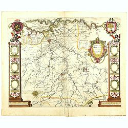
Quarta pars Brabantiae cujus caput Sylvaducis.
The coat of arms of Brabant and 's-Hertogenbosch do appear on the map. But the municipal arms in the columns on right and left-hand side have not yet been filled in. The...
Place & Date: Amsterdam, 1645
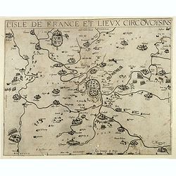
L'Isle de France / Parisiensis agri descrip.
Adorned with a title cartouche and a framing border. Leclerc's "Theatre geographique de France" is an extension of Bouguereau's "Theatre". A refugee w...
Place & Date: Paris, ca. 1619
Inferior Germania.
Very rare map of the Benelux, centered on the Netherlands. According to van der Heijden only known in 6 examples. Two compass-roses with rumb lines but without the names ...
Place & Date: Amsterdam,ca. 1600

Camden's Britannia, Newly Translated into English with Large Additions and Improvements.
Splendid copy fully original colored (inclusive title-cartouche) of the first edition of Gibson's translation.Illustrated with an engraved portrait of Camden by R. White,...
Place & Date: London, F. Collins for A. Swalle and A. / J. Churchill, 1695
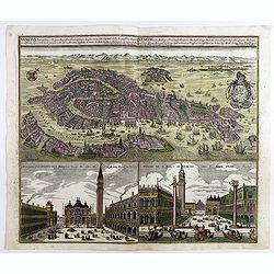
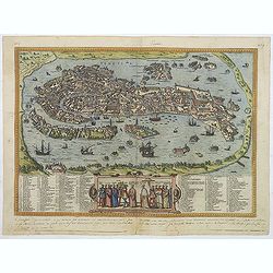
Venetia potentissima e la più magnifica fiorentissimae la più ricca città capitale della Serenissima repubblica . . .
Birds-eye plan view of Venice, depicting the city's architectural landmarks. Below Saint Marco square.Matthaus Seutter the elder first published his "Atlas Geographi...
Place & Date: Augsburg, 1730
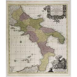
Neapolis Regnum . . .
Map of the region from Naples to Calabria. Cartouche representing Vesuvius erupting.Matthaus Seutter the elder first published his "Atlas Geographicus" in 1720 ...
Place & Date: Ausburg, 1730
Le Canal Royal de Languedoc pour la jonction de l'Océan et de la Mer Méditerranée, dédié et présenté à Mgrs. des Estats de Languedoc.
Title at the top, in a cartouche illustrated with allegorical figures, with a garland of shields to the arms of the lords of the lands touched by the Canal, with three me...
Place & Date: Paris, 1697
Venetia. (Venice)
Precise, beautiful bird's-eye town-view of Venice, clearly depicting the city's architectural landmark. The surrounding lagoon is animated with a great variety of sailing...
Place & Date: Cologne, 1590
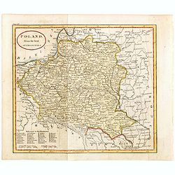
Poland from the best authorities.
Detailed map of Poland from "A New Geographical, Historical, and Commercial Grammar", by William Guthrie. William Guthrie (later engraver for Carey) London, UK....
Place & Date: London, 1805
![Homme Kamtschadale [together with] Femme Kamtschadale.](/uploads/cache/36922-250x250.jpg)
Homme Kamtschadale [together with] Femme Kamtschadale.
Set of two originally hand-colored mezzotints of Native Russians engraved by Félix Mixelle and Lachaussée Jeune after Jacques Grasset de Saint-Sauveur.As an etcher, dra...
Place & Date: Paris,1801-1806
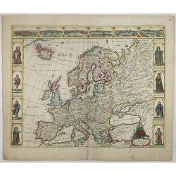
Nova Europae descriptio.
A fine "carte à figures"- map with four panels in columns on each side show portraits of Kings and Queens of European countries. The top border contains panora...
Place & Date: Amsterdam, 1660
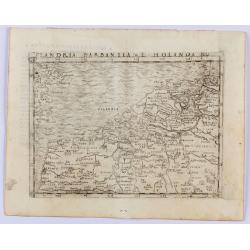
Flandria Barbantia e Holanda No.
Gastaldi's modern map of the Low Countries of the Netherlands, Belgium and Luxembourg. It includes parts of England, France and Germany.According to van der Heijden This ...
Place & Date: Venice, 1548
Selling price: $450
Sold in 2021
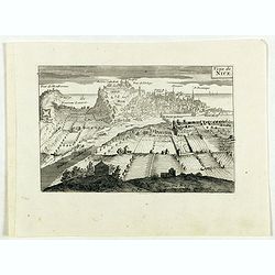
Veüe de Nice.
Engraved birds eye view of Nice. Shows rivers, canals, bridges, landmarks, farms and buildings. Relief shown pictorially.
Place & Date: Paris, 1692
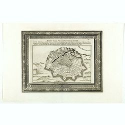
Projet de la forteresse de Nice.
Nice city plan of Nice at the Mediterranean sea. From the " Les forces de l'Europe, ou description des principales villes, avec leurs fortifications".
Place & Date: Leiden, 1729
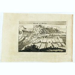
Veue de Nice.
Engraved birds eye view of Nice. Shows rivers, canals, bridges, landmarks, farms and buildings. Relief shown pictorially.
Place & Date: Paris, 1692
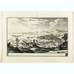
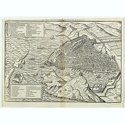
Massilia - Marseille.
Detailed bird's-eye view of the town of Marseille. From Merian's Theatrum Europaeum. To the bottom a lettered key to the principal places in town.
Place & Date: Frankfurt 1650
Die statt Montpellier . . .
Panoramic view of Montpellier by Sebastian Münster. Below the engraving a letterpress key. From the German edition of Sebastian Munster's Cosmography, "Cosmographey...
Place & Date: Basel, Heinrich Petri, 1574
Valencena . . .
Eye-bird view of Valenciennes.
Place & Date: Anvers, 1590
Le vray portraict de la Ville de Marseille.
Fine wood cut bird's-eye view of Marseille. Decorated with several ship in the harbour and on the sea. To the left two keys describing the main buildings and places. Publ...
Place & Date: Paris, 1575
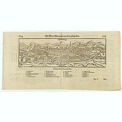
Lutetia Parisiorum urbs, toto orbe celeberrima notissimaque, caput regni Franciae.
Early bird's eye view of Paris, called at the time Lutetia. From a French text edition of S. Münster's Cosmographia, which is a short and complete summary of Renaissance...
Place & Date: Basle, 1550-1580
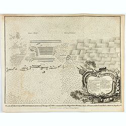
Plan of ye Battle of Wynendale between ye Troops of ye Allies commanded by Major Gen. Webb & those of France under Count de La Motte Sept. 28 1708.
An interesting copper engraved battle plan of Pinedale during the War of the Spanish Succession, showing the position of General Webb's troops in order to protect an alli...
Place & Date: London, 1743
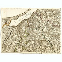
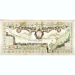
(Sheet X with Puk Bay from) General Tableau zur Karte von Alt Ost und West Preussen nebst dem aufgenommenen Trigonometrischen Netz. . .
Sheet IV with Zalew Wislany and the towns of Elblag, Paslek, Braniewo, etc of this important multi sheet map of Prussia, Lithuania and Poland.The rare first edition of th...
Place & Date: Berlin, 1802-1810
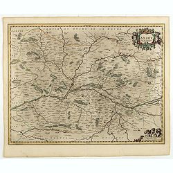
Aniou. . .
Decorative map centered on the Loire valley. Fine title cartouche in upper right corner.
Place & Date: Amsterdam, 1650
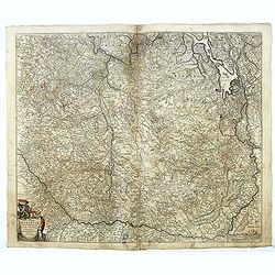
Tabula Ducatus Brabantiae continens Marchionatum Sacri Imperii et Dominium Mechliniense emendate à F. de Wit 1666
Shows present-day Belgium and Dutch province of Brabant. Including the Maas and Waal rivers. Shows Antwerp, Brussels, Namur, Liege and Venlo among other towns and cities....
Place & Date: Amsterdam, 1680
Selling price: $25
Sold in 2016
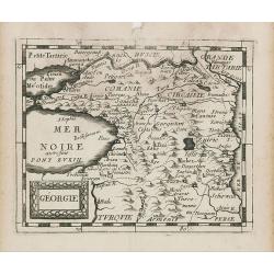
Géorgie.
Uncommon miniature map of Ukraine, from Pierre Duval's La Geographie Universeille dated 1676. Following his Cartes de geographie in 1657, Pierre Duval published this smal...
Place & Date: Paris, 1676
Meklenburg Ducatus.
Very detailed map of the northern part of Germany decorated with a coat of arms, a windrose and two saling ships.From the rare atlas Appendix, published in a very small n...
Place & Date: Amsterdam, 1629-1630
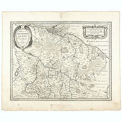
Ducatus Luneburgensis
Very detailed map centered on Albis river and the cities of Hamburg and Lunburg to the north. Also showing Bremen.
Place & Date: Amsterdam, 1629-1630
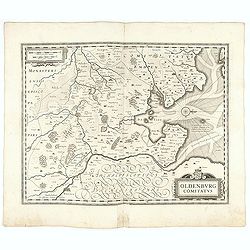
Oldenburg Comitatus
A map of the northern part of Germany centered on Oldenburg. Also showing Bremen. North to the right. The decoration consists with a windrose and a title cartouche surmou...
Place & Date: Amsterdam, 1629-1630
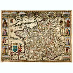
Gallia. Nova Galliae descriptio . . .
Very rare and early map of France with figures on three sides with views of cities, portraits (Henri IV and Marie de Medicis) and costumes. The map was directly influence...
Place & Date: Amsterdam, 1616
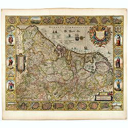
Belgii sive Germaniae Inferioris accuratissima tabula.
Very rare and very decorative map with in the right and left borders costumed figures and town plans alternately. In top and bottom border town plans and views.Separate p...
Place & Date: Amsterdam, 1631
![Plan de Mons ville capitale du comté de Haynaut. [MONS]](/uploads/cache/39799-250x250.jpg)
Plan de Mons ville capitale du comté de Haynaut. [MONS]
Charming little plan of the city of Mons in Belgium, engraved by Inselin, with a lettered key (A-V) in lower right corner.
Place & Date: Paris, 1750
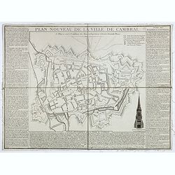
Plan nouveau de la ville de Cambrai.
Nice town-plan of Cambrai, with its fortifications and the citadel, decorated with the cathedral in lower right corner. The borders contain a historical description of th...
Place & Date: Cambrai, 1814
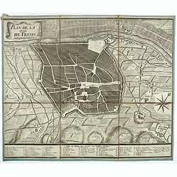
Plan de la ville de Treves.
Very rare town-plan of Trier by Didier Bugnon (1676-1736), geographer of the Duke of Lorraine. With numbered key (1-57) of the main buildings and buildings of the city. T...
Place & Date: Paris?, 1720
Vue perspective de la Ville et Forteresse Electorale de Koningstein, et de la Montagne de Lilienstein avec ses environs du côté du Couchant, dépendant des Etats de Saxe, appartenant à Sa Majesté le Roy de Pologne.
Perspective view of Königstein fortress, situated near to Dresden in Saxony. To the left the Fortress and in the foreground the river Elbe. The castle was inhabited by A...
Place & Date: Paris, 1760
![[Les anciennes provinces Françaises à la ville de Saint Denis].](/uploads/cache/41684-250x250.jpg)
[Les anciennes provinces Françaises à la ville de Saint Denis].
Nine small chromolithography's trade cards for Ville de Saint Denis, each with French regions and places, with description in French on each verso.Cards of the regions : ...
Place & Date: Paris, circa 1900
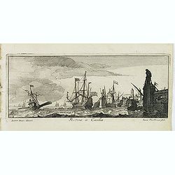
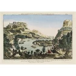
Retimo in Candia. (Rethymno)
Magnificent panoramic of Rethymno on Crete. Engraved by Lucas Vostermans II, who was born in 1624, in the same year when the family moved to England for six years. He wa...
Place & Date: Antwerp, c.1690
Selling price: $160
Sold in 2011
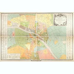
Plan des paroisses de Paris avec la distinction des parties éparses qui en dépendent dressé... par J. Junié, Ingén. Géogr. De Monseigneur l'Archeveque et géomètre des Eaux et forêts de ...
Large wall map size plan of Paris in 4 separate sheets, if joined forming a plan of Paris of 93 x 60cm. This plan is a 1904 version of a manuscript plan drawn in 1786 by ...
Place & Date: Paris, Service des Travaux historiques de la Ville de Paris, 1904
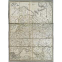
General karte vom europaischen Russland.
Rare second edition of a lithographed wall map of the European part of the Russian empire, at a scale of about 1:3,200,000. With the title in a elaborately decorated lett...
Place & Date: Weimar, Geographisches Institut, 1840
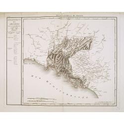
Département des Apennins Divisé en 3 Arrondissemens et en 18 cantons.
Published in the "Atlas National de France" at Chanlaire. Engraved by P.A.F. Tardieu. Represents the department of Apennines which was under French administrati...
Place & Date: Paris, 1790-1811
![[Les anciennes provinces Françaises à la ville de Saint Denis].](/uploads/cache/41681-250x250.jpg)
[Les anciennes provinces Françaises à la ville de Saint Denis].
Nine small chromolithography's trade cards for Ville de Saint Denis, each with French regions and places, with description in French on each verso.Cards of the regions : ...
Place & Date: Paris, circa 1900
![[Les anciennes provinces Françaises à la ville de Saint Denis].](/uploads/cache/41683-250x250.jpg)
[Les anciennes provinces Françaises à la ville de Saint Denis].
Nine small chromolithography trade cards for Ville de Saint-Denis, each with French regions and places, with description in French on each verso.Cards of the regions: Lor...
Place & Date: Paris, circa 1900
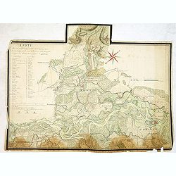
Carte du cours du Rhin dpuis le fort de Schengen jusqu'à Lauterbourg. . .
Beautiful manuscript map of the region around Rastatt and the siege of 1714 signed with the French emperor Charles VI of Habsburg. In top with a small extension of the ma...
Place & Date: Germany, France, c. 1714
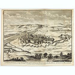
A view of Cassel, a very strong city in Italy, taken by the Duke of Savoy in Decem.r 1706
An interesting copper engraved plan of the Fortification of Cassel in Italy, with an attractive rococo cartouche, showing an overview of the battlefield and surrounding a...
Place & Date: London, 1743