Browse Listings in Europe
![Map of the Occupied Areas. Carte des Zones d'Occupation. Der Besatzungs-Zonen mit Neuen Postleitgebieten. Karta Okkupacionnych Zon [in Cyrillic.]](/uploads/cache/42060-250x250.jpg)
Map of the Occupied Areas. Carte des Zones d'Occupation. Der Besatzungs-Zonen mit Neuen Postleitgebieten. Karta Okkupacionnych Zon [in Cyrillic.]
A poster map of Germany and Austria showing the Allied occupation zones as agreed at the Potsdam Conference after the end of the Second World War, with an inset detail of...
- $350 / ≈ €309
Place & Date: Frankfurt-am-Maine: Atlanta-Service, 1946
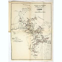
MEMORANDUM Vlade Demokratske Federativne Jugoslavije po pitanju Juliske Krajine i drugih jugoslavenskih teritorija pod Italijom.
Memorandum of the government of the Democratic Federative Yugoslavia concerning the questions of the Jilian March and other Yugoslav territories under Italy.Julian March ...
- $300 / ≈ €265
Place & Date: London, 1946
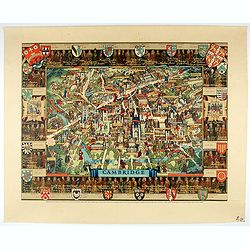
Cambridge.
Though the city had endured significant damage during the Second World War, which ended only a few years prior to publication, there is little indication of the destructi...
- $550 / ≈ €485
Place & Date: London, 1948

Air France - Corse.
Corsica poster for Air France, by Raoul Éric Castel (1915 - 1997) and published by Havas. Signed has work with Éric, he was born in Lyon and made many fine travel poste...
- $1200 / ≈ €1059
Place & Date: Imprimerie Perceval Paris, ca. 1940-1950
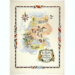
L'Europe Centrale et Orientale.
Pictorial tourism poster of central and eastern Europe, showing different life scenes relative to the culture's country.Learn more about pictorial maps. [+]
- $100 / ≈ €88
Place & Date: Paris, 1951
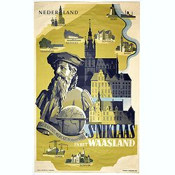
Sint Niklaas en het Waasland Gerardus Mercator Museum.
Poster showing a portrait of Gerard Mercator, set behind a globe and the town hall of St. Niklaas. Showing a map of the region containing pictorial vignets of Overmere, K...
- $500 / ≈ €441
Place & Date: Brussels, 1951
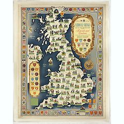
National saving map og the British Isles . . .
A brilliantly eccentric poster showing the festivals, customs of the British Isles with the arms and seals of the counties.Founded in 1861, National Savings is a state-ow...
- $450 / ≈ €397
Place & Date: London, 1951
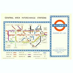
1953 Harry Beck London Underground map.
Published in the Queen's coronation year. A London Underground map (double sided).
- $150 / ≈ €132
Place & Date: London, 1953
![[Pictorial map of Georgia (Caucasus)].](/uploads/cache/44292-250x250.jpg)
[Pictorial map of Georgia (Caucasus)].
A scarce pictorial map of a region in Georgia in the Caucasus. Map is entirely in Russian, complete with legend at base of map, with small thumbnail pictures and symbols ...
- $150 / ≈ €132
Place & Date: Moscow, 1963
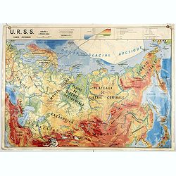
U.S.S.R. Carte Physique. / U.S.S.R. Carte Population.
An unusual school map with on one side a physical map of Russia on verso a map of Russia according to population. Prepared by Pierre Serryn (1916-2002) who was professor ...
- $200 / ≈ €177
Place & Date: St-Germain-en-Laye, 1965
U.S.S.R. Carte Agricole. / U.S.S.R. Carte Industries et communications.
An unusual school map with on one side an agricultural map of Russia on verso a map of Russia showing communication an according to population. Prepared by Pierre Serryn ...
- $200 / ≈ €177
Place & Date: St-Germain-en-Laye, 1965
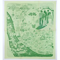
Beatles Map.
A lovely example of the scarce 'Beatles Map' of Liverpool, published in 1974 to commemorate the buildings and places where the Beatles started their stellar careers. The ...
- $750 / ≈ €662
Place & Date: Liverpool, 1974
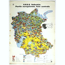
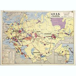
U.R.S.S. Industrie. Partie européenne, Asie centrale. (3)
Map of Eastern Russia. Propaganda poster for Russia's industry. Text in French. Editions de l'Agence de presse Novosti".More about War Maps & Propaganda maps [+]
- $100 / ≈ €88
Place & Date: USSR, 1978
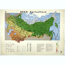
U.R.S.S. Agriculture. (6)
Map of Russia. Propaganda poster for Russia's in and export of industrial goods. With a key in bottom. Text in French. Editions de l'Agence de presse Novosti".More a...
- $100 / ≈ €88
Place & Date: USSR, 1978
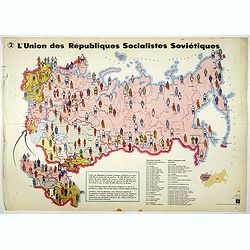
L'Union des Républiques socialistes Soviétiques. (2)
Map of Russia. Propaganda poster showing Russia' s population. With a key. Text in French. Editions de l'Agence de presse Novosti".More about War Maps & Propagan...
- $100 / ≈ €88
Place & Date: USSR, 1978
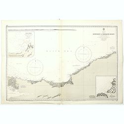
Black sea - Sheet IX - Bosporus to Kerempe Burnu . . .
A highly corrected version of Admiralty chart 2238 originally published 16th June 1854. Edition Date 1980.Detailed chart of Bosporus. With prohibited landing places in pu...
- $100 / ≈ €88
Place & Date: London, 1854-1980