Browse Listings
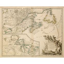
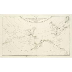
Partie de l'Amerique Septent ...
A fine copy of this map of New Foundland, Nova Scotia and the course of the St.Laurence to Lake Ontario. An inset shows Bellini's famous and important map of the Great La...
- $800 / ≈ €749
Place & Date: Paris, 1755
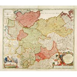
Circulus Saxoniae inferioris.
Detailed map of Saxen, including Bremen, Berlin, Lübeck, etc. Johann Baptist Homann (1663-1724) was a German engraver and publisher, who established himself and his fami...
- $200 / ≈ €187
Place & Date: Nuremberg 1740
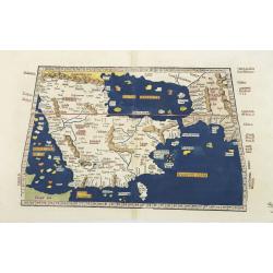
Tabula Sexta Asia (Arabian Peninsula)
This is a very desirable early Ptolemaic woodblock map of the Arabian Peninsula, here called Arabia Felix. The map is presented on a trapezoidal projection with paralle...
- $2200 / ≈ €2059
Place & Date: Strassburg, 1525
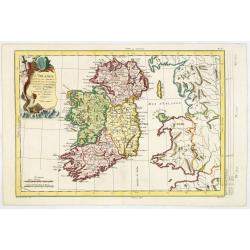
L'Irlande. . .
Map of Ireland, prepared by M. Philippe, embellished with a decorative title cartouche. Engraved by Vallet.
- $300 / ≈ €281
Place & Date: Paris, 1779
Carta Hydrographica oder Algemeine Welt. . .
World map in Mercator projection. Showing California as an island. In the upper left and right-hand corner two ships. The map is showing the important trade routes.
Place & Date: Augsburg, 1720
L'Utrecht. . .
Although not renowned for the originality of his work, Pieter van der Aa is highly thought of for the design and quality of his output. Showing Dutch province of Utrecht....
Place & Date: Amsterdam, 1713
Carte du Brabant, suivant les Nouvelles Observations de Messrs de L'Academie Royale des Sciences etc. . .
Although not renowned for the originality of his work, Pieter van der Aa is highly thought of for the design and quality of his output. Showing the present-day Dutch and ...
- $300 / ≈ €281
Place & Date: Amsterdam, 1713
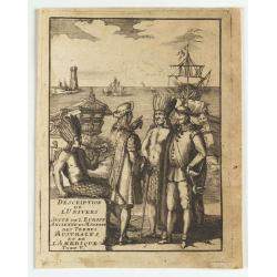
(title page) Description de L'Univers suite de L'Europe ancienne et moderne des terres Australes et de L'Amerique Tome V.
Showing arrival of Francis Drake in the New World.
- $150 / ≈ €140
Place & Date: France, 1683
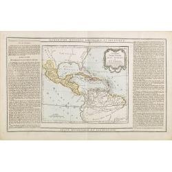
Guayane, Terre Ferme Isles Antilles. . .
Map showing Mexico, Cuba, Central America. Left and right a box with geographical information for each part country on the continent.Prepared by Louis Brion de la Tour an...
- $200 / ≈ €187
Place & Date: Paris, 1790
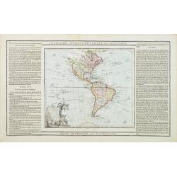
L' Amerique dressée pour l'étude de la géographie . . .
Map showing the American continent. California with a large inlet. Some major cities, bodies of water, and geographic features are marked. There are illustrations of ship...
- $200 / ≈ €187
Place & Date: Paris, 1790
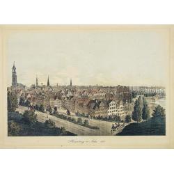
Hamburg im Jahre 1813
Decorative lithographed view of Hamburg. The print is issued in colors but finished by hand.
- $150 / ≈ €140
Place & Date: Germany,1820
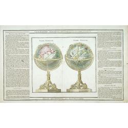
Globe Terrestre. / Globe Celeste.
Showing a terrestrial and celestial spheres. Left and right a box with geographical information for spheres of different types.Prepared by Louis Brion de la Tour and publ...
- $400 / ≈ €374
Place & Date: Paris 1790
Karte von den N.W.Amerikanische und N.O.E. Asia..
A detailed large-scale map showing the Bering strait, Kamchatka, Alaska, and much of North America. While the Russian coastline is shown with reasonable accuracy. Showing...
- $500 / ≈ €468
Place & Date: Vienna 1788

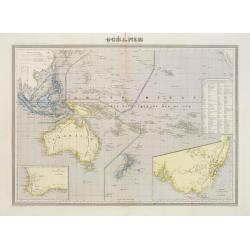
Océanie.
Decorative map of the Pacific Ocean including Indonesia, Australia, New Zealand and California. Lower right inset map Détails de la Nouvelle Galles Méridionale , includ...
- $120 / ≈ €112
Place & Date: Paris 1880
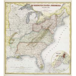
Die Vereinigten Staten von Nordamerika (Ostlicher theil).
Detailed map of eastern part of the United states until the border of Texas. In lower right hand corner inset map of New York Bay, including, NY, Newark, Staten Island.Th...
- $450 / ≈ €421
Place & Date: Weimar, 1874
Carte de la Mer Rouge, depuis Moka jusqu'a Gedda.
Chart of the Red Sea. With 3 inset maps of Shake Omare, Goofs and Gedan.D'Après De Mannevillette (1707-1780) was one of France's first hydrographers. When the first edit...
- $450 / ≈ €421
Place & Date: Paris, 1775

Plan de la Rade de Gedda situee de la Cote d'Arabie sur la Mer Rouge.
Chart of the area around city of Gedda in the Red Sea. D'Après De Mannevillette (1707-1780) was one of Franc's first hydrographers. When the first edition of his Atlas L...
- $600 / ≈ €561
Place & Date: Paris, 1745
Carte de L'entrée du Golfe de la Mer Rouge.
Chart of the Gulf of Aden with the coast line of Yemen, the Island Socotra and the entrance of the Red Sea. With 2 inset charts off-shore of the town Mocha.D'Après De Ma...
- $400 / ≈ €374
Place & Date: Paris, 1753
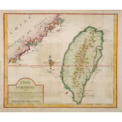
L'Isle Formose et parties des Costes de la Chine. . .
This well-known map of Taiwan is prepared by Jacques Nicolas Bellin and was based on Jesuit information. The text along the island's east-coast claims: Of this coast litt...
- $600 / ≈ €561
Place & Date: Paris, 1763
De Maria kerk te Leiden.
In the eighteenth and nineteenth centuries, there were many popular speciality establishments in Paris, Augsburg and London that produced optical viewing devices and spec...
- $200 / ≈ €187
Place & Date: Paris, 1760
Carte L'Amérique Septentrionale..
Detailed map of North America, prepared by J.G.Barbié du Bocage.Engraved by Ch.Smith, published by Basset who was established in Paris, rue de Seine 33.
- $100 / ≈ €94
Place & Date: Paris, 1848
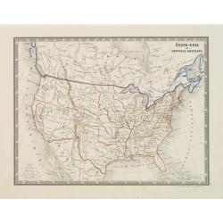
États-Unis et Nouvelle Bretagne.
Detailed map of the United States. All different States are divided by an orange border line.
- $120 / ≈ €112
Place & Date: Paris, 1880
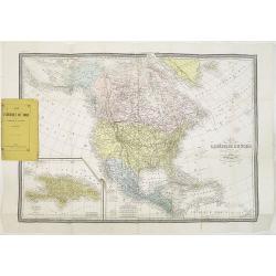
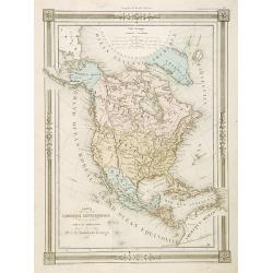
Carte de L'Amérique du Nord. . .
Detailed map of Nord America and Central America giving good detail along the east coast and the Lakes. Including San Francisco, Monterey, etc.With inset map of Dominican...
- $250 / ≈ €234
Place & Date: Paris, 1870
Factorij der Nederlanders op Firato.. 1609-1641.
Bird's-eye view of Hirado, a trading post of the V.O.C. from 1609 until 1641.Von Siebold was born in Wurzburg, in Germany, and worked for the Dutch government as a doctor...
- $1500 / ≈ €1404
Place & Date: Leiden, 1832-1852
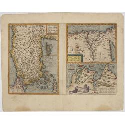
Natoliae.. Aegypti recentior.. Carthaginis (3 maps on 1 sheet)
Map to the left east to the top. Detailed map Turkey, including Cyprus and Crete. Also map of the Nile delta and another map of Tunis. From "Theatrum Orbis Terrarum&...
- $500 / ≈ €468
Place & Date: Antwerp, 1609-1641

Natoliae.. Aegypti recentior.. Carthaginis ( 3 maps on 1 sheet)
Three maps on one sheet. Map to the left east to the top. Detailed map Turkey, including Cyprus and Crete. Also map of the Nile delta and another map of Tunis. From "...
- $750 / ≈ €702
Place & Date: Antwerp, 1587
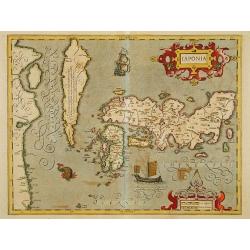
Japonia.
Jodocus Hondius' fine map early 17th-century map of the islands of Japan, was first issued as one of the new maps in the expended Mercator Hondius Atlas of 1606.The map i...
- $1500 / ≈ €1404
Place & Date: Amsterdam, 1606-1620
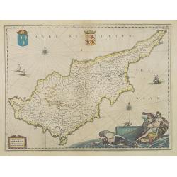
Cyprus Insulae.
Janssonius' beautiful map of Cyprus embellished with a very decorative title cartouche.
Place & Date: Amsterdam, 1640
Selling price: $1800
Sold in 2008

La Florida/ Peruviae Auriferae regionis Typus/ Guastecan.
The Chaves map of Florida is a prime example of an explorer's map since it records the recent discoveries of Cabeza de Vaca, De Soto, and Moscoso. The map revealed little...
- $1400 / ≈ €1310
Place & Date: Antwerp, 1592
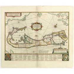
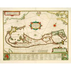
Mappa Aestivarum Insularum, alias Barmudas.
This magnificent map is based on the famous survey by John Norwood of the Bermuda Company in 1618. The map shows the division into the original Tribes and shows the vario...
- $2000 / ≈ €1871
Place & Date: Amsterdam, 1645
Die Vereinigten Staaten von Nord Amerika..
Uncommon map of the east coast of North America, including the Great Lakes area. To the right inset map of New Foundland. After the map by William Faden of 1783. With col...
- $500 / ≈ €468
Place & Date: Germany, 1790
Océanie dresée par C.V.Monin.
Fine and uncommon map including Australia, New Zealand, Indonesia, with inset maps of New Zealand, Victoria/New South Wales and Western Australia including Albany and Per...
- $150 / ≈ €140
Place & Date: Paris, 1875

Die Republic Holland oder die Verenigte Niederlande..
Charming map of the Netherlands, with inset maps of Novi Belgium area in America and Indonesia. With a fine cartouche.
- $250 / ≈ €234
Place & Date: Leipzig 1749
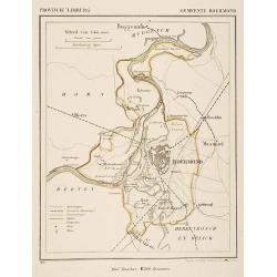
Gemeente Roermond.
From: J.Kuyper Gemeente-Atlas van Nederland naar officieele bronnen bewerkt. He was one of the most important of the Dutch atlas editors of the second half of the 19th ce...
- $90 / ≈ €84
Place & Date: Leeuwarden 1867
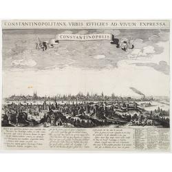
Constantinopolitanae urbis effigies ad vivum expressa.
Extremely rare panoramic view of Istanbul published by Rombout van den Hoeye. With a numbered key (1-29) to principal places in town and a Latin, Dutch, and French poem. ...
- $3500 / ≈ €3275
Place & Date: Amsterdam, 1650
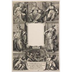
(Title page) Principum Christianorum Stemmata.
Uncommon title page. From Antonio Albizzi, "Principum Christianorum Stemmata ab Antonio Albizio Nobili Florentino collecta: et Cum brevibus ejusdem notationibus ex A...
- $200 / ≈ €187
Place & Date: Strasbourg, 1610

Baie Louis XVI. . .
Very decorative and colorful lithography of an elegant French interior. From La Tenture Française published by G.Mathière, 32/34 Rue de Charonne, Paris.
- $100 / ≈ €94
Place & Date: Paris, 1882
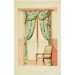
Fenètre et siège empire.
Very decorative and colorful lithography of an elegant French interior. From La Tenture Française, published by G.Mathière, 32/34 Rue de Charonne, Paris.
- $50 / ≈ €47
Place & Date: Paris, 1882
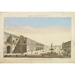
Vue perspective de la Grande Place de St.Francois a Seville.
So-called optical print. Daumont was a well-known publisher of optical prints, established in Paris. In the eighteenth and nineteenth centuries there were many popular sp...
Place & Date: Paris, 1760

Vue interieur de l'Eglise de S.Pierre de Rome.
So-called optical print of St. Pieter church of Rome. A well-known publisher of optical prints, established in Paris. In the eighteenth and nineteenth centuries there wer...
Place & Date: Paris, 1760
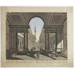
Vue de l'Entree de la Cour.. de la rue de l'Arno a Florence
So-called optical print of Arno Street in Florence, in Tuscany region.Probst was the best-known publishers of optical prints, established in Augsburg.In the eighteenth an...
- $250 / ≈ €234
Place & Date: Augsburg 1750
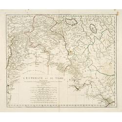
L'Euphrate et Le Tigre.
A detailed map prepared by D'Anville. Covering the Syrian Desert, Lebanon, and the mouth of the Tigris in the Persian Gulf. Including Babylon, Tripoli, etc.
- $150 / ≈ €140
Place & Date: Nuremberg, 1783
Gezicht op het Meer Tokaitç / Biwa-ko.
View of Lake Biwa near Kyoto.Von Siebold was born in Wurtzburg, in Germany, and worked for the Dutch government as a doctor in Java. In Japan, where Von Siebold arrived i...
- $1500 / ≈ €1404
Place & Date: Leiden, 1832-1852

Muzijkinstrumenten.
Showing Japanese drums.Von Siebold was born in Würzburg, in Germany, and worked for the Dutch government as a doctor in Java. In Japan, where Von Siebold arrived in 1823...
- $200 / ≈ €187
Place & Date: Leiden, 1832-1852
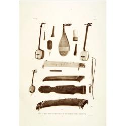
Muzijkinstrumenten.
Showing several Japanese string musical instruments, a.o.: Samisen and Kokiu.Von Siebold was born in Wurtzburg, in Germany, and worked for the Dutch government as a docto...
- $200 / ≈ €187
Place & Date: Leiden, 1832-1852
Erpach.
The town of Heidelberg is in most southern point on the map, including the rivers Rhine, Necker and Main.Rare issue published in Oxford. In 1680 the copper plates of Jans...
- $100 / ≈ €94
Place & Date: Oxford, 1680
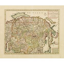
Nieuwe kaart van Tartarie.
A map of Tartary, Korea and part of Japan. The map is most notable for the confusion between Kamchatka and Iesso. Hokaido labelled Compagnie LandFrom: Nieuwe en Beknopte ...
- $450 / ≈ €421
Place & Date: Amsterdam 1750
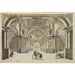
Vue des trois Gallerie, du Palais des Arts..Science a Rome.
So-called optical print. Daumont was a well-known publisher of optical prints, established in Paris. In the eighteenth and nineteenth centuries there were many popular sp...
Place & Date: Paris, 1760

No title: training a horse.
After a design by Silva.
- $75 / ≈ €70
Place & Date: Italy, c. 1800

't dorp Aalst.
Rare print of the old church of Aalst (near Eindhoven), from Vaderlandsche gezichten of afbeeldingen.. by J.Bulthuis, printed by H.Gartman in Amsterdam.
- $100 / ≈ €94
Place & Date: Amsterdam 1786-1792
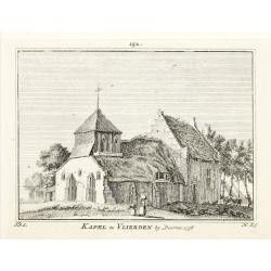
Kapel van Vlierden.
Etching of the old chapel of Vlierden (near Deurne), from Het Verheerlijkt Nederland of Kabinet van hedendaagsche gezichten.. published by Isaac Tirion in Amsterdam. Etch...
- $80 / ≈ €75
Place & Date: Amsterdam 1745-1774
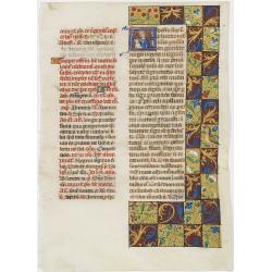
Leaf on vellum from a manuscript Brevier.
RECTO: One 4-line illuminated initial depicting Maria and child and two 1-line initials in burnished gold on colored grounds. Panel border of acanthus leaves, flowers and...
- $2000 / ≈ €1871
Place & Date: Tours, c.1485
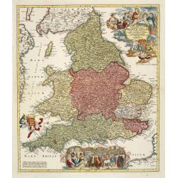
Magnae Britanniae pars meridionalis in qua regnum Angliae. . .
Johann Baptist Homann's well-engraved map has a large decorative cartouche at top right and a large scene at bottom center showing a throned ruler, presumably George I, h...
Place & Date: Nuremberg, 1740
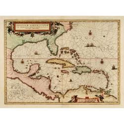
Insulae Americanae in oceano septentrionali..
Showing the Gulf of Mexico and the West Indian Islands, and the adjacent North and South American coastlines.The cartography is based on the rare Gerritz chart of 1631. T...
- $1750 / ≈ €1638
Place & Date: Amsterdam, 1660

Belgium Foederatum auctius et emendatius edit..
Map of the northern part of the Netherlands. With a decorative title cartouche, with an inset map of South East Asia.
- $500 / ≈ €468
Place & Date: Augsburg, 1760
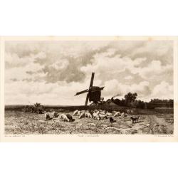
Dutch windmill with sheeps.
Attractive lithography showing a typical Dutch windmill with sheep's on foreground, lithographed by F.H.Weissenbruch after a painting by Jan van Lokhorst. Published in Ku...
- $60 / ≈ €56
Place & Date: The Hague 1866
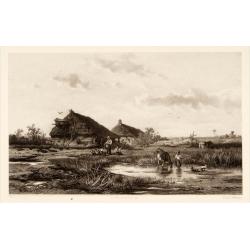
Dutch landscape.
Attractive lithography showing a typical Dutch landscape, lithographed by F.H.Weissenbruch after a painting by W.Roelofs. Published in Kunst Kroniek.
- $50 / ≈ €47
Place & Date: The Hague, 1865
Dutch ice-scene.
Attractive lithography showing a typical Dutch ice-scene, lithographed by C.W. Mieling after a painting by J.B. Jongkind. Published in Kunst Kroniek.
- $75 / ≈ €70
Place & Date: The Hague, 1850
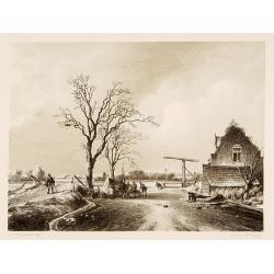
Den Briel.
Attractive lithography showing a typical Dutch street scene of Den Briel in the middle of the 19th century, lithographed by A.C.Cramer after a painting by Cornelis Spring...
- $50 / ≈ €47
Place & Date: The Hague, 1869
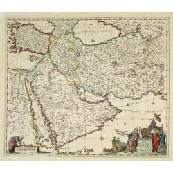
Nova Persiae Armeniae Natoliae et Arabiae.
East from Cyprus to Iran with numerous place names and ornamental cartouches below. There are vignettes of sailing ships in sea areas and the land divisions of the time a...
- $1500 / ≈ €1404
Place & Date: Amsterdam, 1690
![[Titlepage] Nomenclator Ptolemaicus..](/uploads/cache/06436-250x250.jpg)
[Titlepage] Nomenclator Ptolemaicus..
Title page from a Ortelius Atlas part called: Nomenclator , containing a register of place names in antiquity. Letterpress with copper engraved print (60x60mm) of the eas...
- $150 / ≈ €140
Place & Date: Antwerp, 1609
![[Title page] Recueil de tous les Costumes.](/uploads/cache/06437-250x250.jpg)
[Title page] Recueil de tous les Costumes.
Uncommon and decorative title page of a man holding a curtain with title and a woman reading a book. With a dedication to Mr. Bignon, who was librarian of the King of Fra...
- $200 / ≈ €187
Place & Date: Paris, 1779
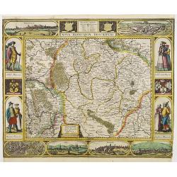
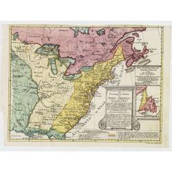
Nova Franconiae Descriptio.
In 1626 Abraham Goos engraved a single-sheet "carte à figures"- map of Franconia with decorative borders for Joannes Janssonius. In the center part of the top ...
- $3000 / ≈ €2807
Place & Date: Amsterdam, 1626
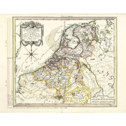
Chorographie des Pays Bas Hollandois et Autrichiens. . .
Fine detailed and uncommon map of the modern Netherlands, Belgium and Luxembourg. Prepared by Etienne André Philippe de Pretot (1708-1787) after sources according to the...
- $200 / ≈ €187
Place & Date: Paris, 1772
![[Drawing of a Tulip]](/uploads/cache/06597-250x250.jpg)
[Drawing of a Tulip]
Very detailed and well executed tulip drawing by an unknown artist belonging to the School of Anthony Claesz (1607/8-1649)This drawing was made for a 'Tulip book' painted...
- $1200 / ≈ €1123
Place & Date: The Netherlands c.1700
![[Drawing of a Tulip]](/uploads/cache/06621-250x250.jpg)
[Drawing of a Tulip]
Very detailed and well-executed tulip drawing by an unknown artist attributed to the School of Anthony Claesz (1607/8-1649)This drawing was made for a 'Tulip book' painte...
- $1500 / ≈ €1404
Place & Date: The Netherlands c.1700
![[Drawing of a Tulip]](/uploads/cache/06622-250x250.jpg)
[Drawing of a Tulip]
Very detailed and well executed tulip drawing by an unknown artist belonging to the School of Anthony Claesz (1607/8-1649)This drawing was made for a 'Tulip book' painted...
- $1500 / ≈ €1404
Place & Date: The Netherlands c.1700
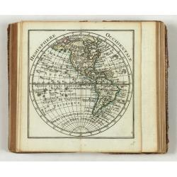
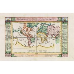
Almanach Géograhique ou petit atlas..
Uncommon miniature atlas with extensive geographical descriptions of mainly European countries.Including a map of the eastern hemisphere, with a curious outline for Austr...
- $1500 / ≈ €1404
Place & Date: Paris, 1770
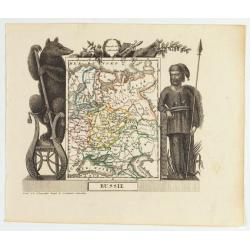
Russie
Attractive map of Russia with decorative borders depicting typical artefacts and produce of the continent. Published in Les jeunes voyageurs en Europe.. . Engraved by J.G...
- $100 / ≈ €94
Place & Date: Brussels, 1824
Silesiae Ducatus..
Centered on Breslaw. Including the towns of Dresden, Crakaw, Pragu, Olmitz, etc.Decorative map prepared by Jonas Scultetus, a Silesian cartographer (1603-1664).
- $600 / ≈ €561
Place & Date: Amsterdam 1660
Silesia Inferior..
Decorative map prepared by Jonas Scultetus, a Silesian cartographer (1603-1664).
- $400 / ≈ €374
Place & Date: Amsterdam, 1650
Die Vereinigten Staten von Nordamerika (Ostlicher theil).
Detailed map of eastern part of the United states. In lower right hand corner inset map of New York Bay, including, NY, Newark, Staten Island.The map is prepared by C.Gr�...
- $450 / ≈ €421
Place & Date: Weimar, 1874
![[Title page from] Le Theatre du Monde ou Nouvel Atlas.](/uploads/cache/06754-250x250.jpg)
[Title page from] Le Theatre du Monde ou Nouvel Atlas.
Architectural frontage without the usual title and imprint printed on paste-on slips.More about title pages [+]
- $250 / ≈ €234
Place & Date: Amsterdam, 1640
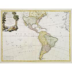
L'Amerique divisée en ses principaux Etats..
Uncommon map published by Lattré. This map is most notable for its depiction of "Mer de L'Ouest" or "Sea of the West". A great sea, easily the size o...
- $900 / ≈ €842
Place & Date: Paris, 1760
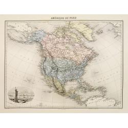
Amérique du Nord.
Decorative map of Northern America from Géographie Universelle, Atlas Migeon. published by J. Migeon. Nice engraving at the lower left hand of New York with the Statue o...
- $125 / ≈ €117
Place & Date: Paris, 1874
![[Title page] Le Theatre du Monde ou Nouvel Atlas.](/uploads/cache/06812-250x250.jpg)
[Title page] Le Theatre du Monde ou Nouvel Atlas.
Architectural frontage with the title and imprint printed on paste-on slips.The map is in a strictly contemporary coloring and of the highest level.Read more about colori...
- $400 / ≈ €374
Place & Date: Amsterdam, 1640
Mappa Aestivarum Insularum, alias Barmudas. . .
It shows the island divided into tribes and lots, and below the map itself appear the coats of arms of Bermuda and England and the names of the first proprietors and the ...
- $2000 / ≈ €1871
Place & Date: Amsterdam, 1645
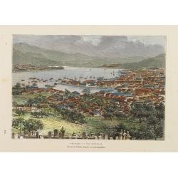
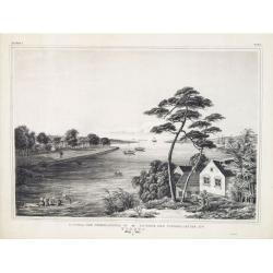
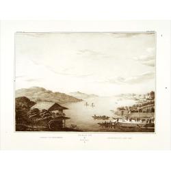
Nagasaki. - Vue générale. Dessin de Taylor, après une photographie.
A bird's-eye view showing Nagasaki Bay. After a photograph by Taylor. Engraved in wood by A.Kohl.Showing the town and natural harbour of Nagasaki.In the harbour the islan...
- $150 / ≈ €140
Place & Date: Paris, 1880
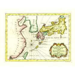
Carte des Isles du Japon et la Presqu'Isle de Coree. . .
A fine map of the islands of Japan, including Korea, Taiwan and the coast of China till Macao.Embellished with fine baroque decorations. Bellin influenced other cartograp...
- $275 / ≈ €257
Place & Date: Paris, 1746
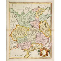
La Chine.
With decorative title cartouche lower right. Good detail of China's mainland with Taiwan and Hainan Province.
- $300 / ≈ €281
Place & Date: Paris, 1767