Browse Listings
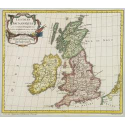
Les Isles Britanniques..
A first state (of 2) dated 1762. Fine map of the British Isles, engraved by E.Dussy. Fine title cartouche upper left engraved by Arrivet. From his Nouvel Atlas Portatif .
Place & Date: Paris, 1762
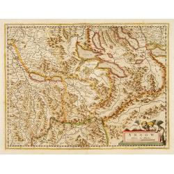
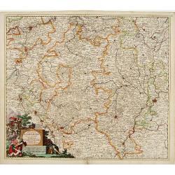
Argow .
Centered on the Bernese and Lucerne. Including the towns of Lucerne, Bern and Thuner- and Lucerner See. Prepared by Gerard Mercator.
Place & Date: Amsterdam, 1639
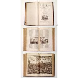
Alle De Wercken, soo Oude als Nieuwe van den Heer Jacob Cats, Ridder, oudt Raadtpensionaris Van Hollandt, &c. : Op nieus vermeerdert met des Autheurs Tachtig-jarig Leven, Huyshoudinge en Bedenckingen op Zorg-vliet.
A very good example of the collected works of the most celebrated Dutch author of the seventeenth century. Illustrated with over 400 engravings after van de Venne by Hond...
- $1900 / ≈ €1778
Place & Date: Amsterdam, 1700
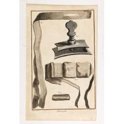
Chirurgie, plate XVIII
Showing bondage from the medical section of Diderot's Encyclopaedia. Engraved by Bernard after a design of Goussier. Very important work as it is giving an inventory of t...
- $100 / ≈ €94
Place & Date: Paris 1779
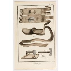
Chirurgie, plate II.
Showing medical instruments and bondage from the medical section of Diderot's Encyclopaedia. Engraved by Bernard after a design of Goussier. Very important work as it is ...
- $80 / ≈ €75
Place & Date: Paris 1779
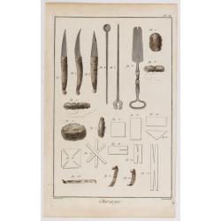
Chirurgie, plate XXXII
Showing medical bondage from the medical section of Diderot's Encyclopaedia. Engraved by Bernard after a design of Goussier. Very important work as it is giving an invent...
- $80 / ≈ €75
Place & Date: Paris 1779
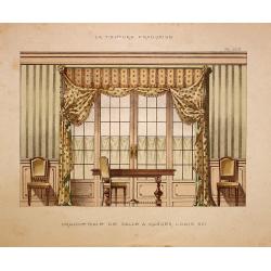
Grande baie de salle a manger Louis XVI.
Very decorative and colorful lithography of an elegant French interior. From La Tenture Française, published by G.MathiÞre, 32/34 Rue de Charonne, Paris.
- $75 / ≈ €70
Place & Date: Paris, 1880
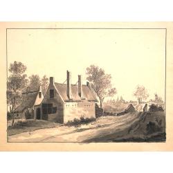
Dutch landscape.
Finely executed water color in pen and ink and gray wash color. Showing a Dutch landscape with farm house and windmills on the horizon.
- $60 / ≈ €56
Place & Date: Probably The Netherlands, ca. 1800
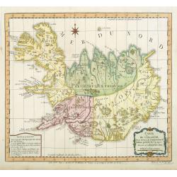
Carte de l'Islande pour servir á la continuation de l'histoire générale des voyages. Dressée sur celle de M. Horrebows.
A good engraved map of the island Iceland, prepared by Bellin after M. Horrebows, with rococo title cartouche in lower right. From l'Histoire générale des voyages.
- $300 / ≈ €281
Place & Date: Paris, 1758
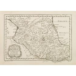
Carte de L'Empire du Mexico.
A good engraved map of Mexico, with rococo title cartouche lower left. From l'Histoire générale des voyages .
- $75 / ≈ €70
Place & Date: Paris, 1754
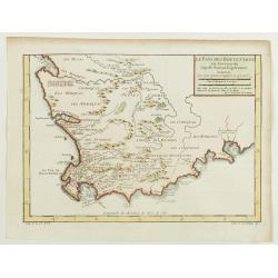
Le Pays des Hottentots aux environs du Cap de Bonne Espérance. . .
A good engraved map of Cape of Good Hope. The geographical features are typical with somewhat exaggerated bays, inlets and prominent mountain ranges. The west coast of th...
- $200 / ≈ €187
Place & Date: Paris, 1748
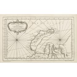
Partie de la Mer Glaciale contenant de la nouvelle Zemble..
A good engraved map of Nova Zembla. The geographical features are typical with somewhat exaggerated bays and inlets. From l'Histoire générale des voyages .
- $80 / ≈ €75
Place & Date: Paris, 1758
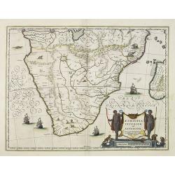
Aethiopia inferior, vel exterior.
The standard map of South Africa throughout the 17th century. The lake out of which the 'Zambere' -the Zambesi- flows is probably based on reports of Lake Ngami, undiscov...
- $575 / ≈ €538
Place & Date: Amsterdam, 1645
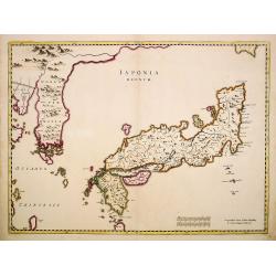
Japonia Regnum.
The first map to correctly show Korea as a peninsula. This was to remain the standard form of Japan until the eighteenth century and although replaced by the maps of Rela...
- $2000 / ≈ €1871
Place & Date: Amsterdam, 1655
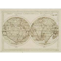
Orbis Terrae compendiosa descriptio.
Modern world map by Rosaccio, consisting of two hemispheres enclosed within a plain border. The engraving is sharp and neat, and is a skilful reduction of Rumold Mercator...
- $1000 / ≈ €936
Place & Date: Venise, 1598/1713
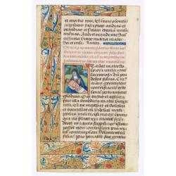
Leaf of vellum, with large miniature of Marry and Christ.
RECTO: Large miniature of Marry and Christ and one 1-line initials in burnished gold, on red ground and line-filler on blue ground. Three-sided illuminated borders of pen...
- $2200 / ≈ €2059
Place & Date: France, c.1480
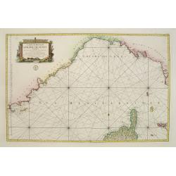
Carte réduite du Golphe de Genes. Conenant partie des cotes de Provence, celles de Piemont, de Genes et de Toscane . . .
Superb sea chart covering the coasts of the French and Italian Riviera's, Tuscany and northern tip of Corsica, prepared by Jacques Nicolas Bellin (1703-1772) the Royal Hy...
Place & Date: Paris, 1768
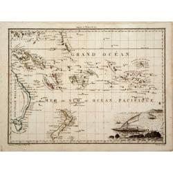
Océanique Oriente.
Drom the Carolines to New Zealand and east to Pitcairn Island with Australia from Torres Strait to Tasmania. Engraved by J.B.Tardieu and prepared by Giraldon.From Conrad ...
- $300 / ≈ €281
Place & Date: Paris, 1809/1812
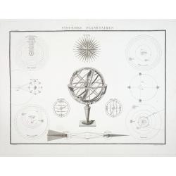
Systémes Planétaires
A charming print showing an armillary globe with smaller circular diagrams illustrating the theories of Ptolemy, Copernicus, Brahe, etc. Published by Alexandre Emile Lapi...
- $150 / ≈ €140
Place & Date: Paris, 1830
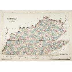
Kentucky.
A detailed lithographed map of Kentucky. Published by Adam (1784-1874) and Charles Black, publishers active in Edinburgh.
- $100 / ≈ €94
Place & Date: Edinburg, 1874
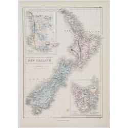
New Zealand.
A detailed lithographed map of New Zealand. With in upper left corner inset-map of Western Australia and in lower right hand corner a map of Van Diemens Land. Published b...
- $100 / ≈ €94
Place & Date: Edinburg, 1874
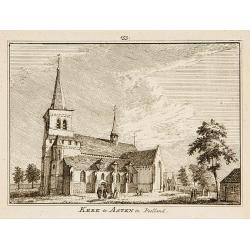
Kerk te Asten in Peelland.
"Etching of the church of Asten, from ""Het Verheerlijkt Nederland of Kabinet van hedendaagsche gezichten.."" published by Isaac Tirion in Amster...
- $80 / ≈ €75
Place & Date: Amsterdam 1745-1774
Persicum Regnum.
The rare Samuel Purchas' edition of the Mercator/Hondius Atlas Minor atlas map. Early map of Turkey, including Cyprus published in his famous collection of voyages His Pi...
- $150 / ≈ €140
Place & Date: London, 1625
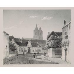
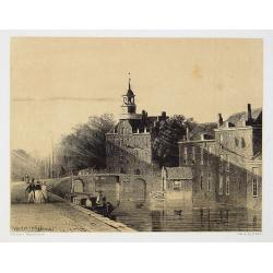
Arnhem
Attractive lithography showing a street scene in Arnhem. Lithographed by Jan Weissenbruch, published by C.W. Mieling, included in Kunst Kroniek.
- $65 / ≈ €61
Place & Date: The Hague, 1851
The Hague
Attractive lithography showing a street scene in The Hague. Lithographed by Jan Weissenbruch, published by K.Fuhri, included in Kunst Kroniek.
- $40 / ≈ €37
Place & Date: The Hague, 1848
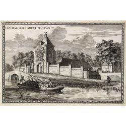
Generaliteits Kruyt-Magasyn.
The print depicts the gunpowder storage in Rotterdam. A most decorative item.
- $50 / ≈ €47
Place & Date: Amsterdam, 1703
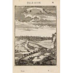
Iedo. (Tokyo)
A late 17th century miniature view of the skyline of Jedo (Tokyo). By Allain Manneson Mallet (1630-1706), a well traveled military engineer and geographer who worked in 1...
- $200 / ≈ €187
Place & Date: Paris, 1683
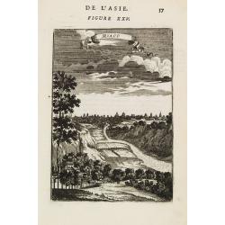
Miaco.
A late 17th century miniature view of the skyline of Miaco (Kyoto). By Allain Manneson Mallet (1630-1706), a well traveled military engineer and geographer who worked in ...
- $200 / ≈ €187
Place & Date: Paris, 1683
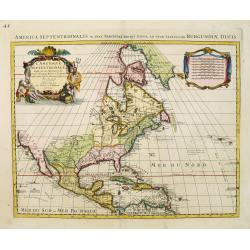
L'Amerique septentrionale, Dressée sur les memoires les plus recens. . .
A very detailed map extending from Hudsons Bay to Panama, and including the West Indies. The map is a later copy of Guillaume de L'Isle's foundation map of North America,...
- $1500 / ≈ €1404
Place & Date: Amsterdam, 1740

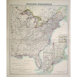
Amérique Septentrionale .. Les Etats Unis..
Very rare state: probably separately issued. Published the same year the Treaty of Paris was signed, this is one of the first maps to provide printed boundary lines for t...
- $3000 / ≈ €2807
Place & Date: Paris, 1786
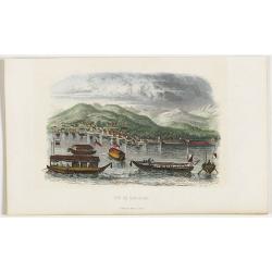
Vue de Nangasaki
View over the town from the water, identifying clearly Deshima with Japanese sloops in the fore ground. Engraved by Alp.Boilly.
- $120 / ≈ €112
Place & Date: Paris, 1842
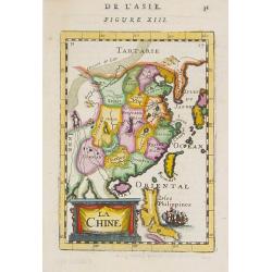
La Chine.
A charming small map of China, Taiwan, Philippines, Korea and Kyushu (Japan). By Allain Manneson Mallet (1630-1706), a well traveled military engineer and geographer who ...
- $300 / ≈ €281
Place & Date: Paris, 1720
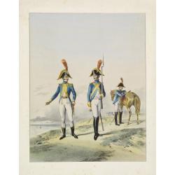
Guides interprètes de l'armee d'Angleterre.
A very decorative lithography of English soldiers about 1804.
- $50 / ≈ €47
Place & Date: France, c.1870
Der curiose und ... Nüssliche Dollmetscher..
Rare atlas and containing geographical descriptions of all continents. Illustrated with 30 very finely engraved and beautifully colored maps in attractive original strong...
- $6000 / ≈ €5614
Place & Date: Augsburg, 1748

Le Vaza ou Perroquet noir/ Le Mascarin.
Decorative lithography from a later edition of ,Histoire naturelle, by Georges-Louis Leclerc, comte de BUFFON, this great naturalist (1707-88) spent the greater part of h...
- $80 / ≈ €75
Place & Date: Paris, 1840
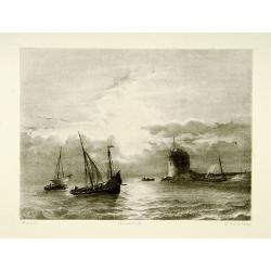
Shipping scene.
Attractive lithography showing Dutch vessels off the Dutch coast, by A.A.Nunnink after a painting by L.Meijer. Published in Kunst Kroniek .
- $60 / ≈ €56
Place & Date: The Hague, 1857
![[Ships at sea]](/uploads/cache/08213-250x250.jpg)
[Ships at sea]
Attractive lithography showing Dutch vessels off the Dutch coast, by F.H.Weissenbruch after a painting by L.Meijer. Published in Kunst Kroniek .
- $50 / ≈ €47
Place & Date: The Hague, 1862
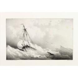
Shipping
Attractive lithography showing Dutch vessels off the Dutch coast, by F.A.Breuhaus de Groot. Published in Kunst Kroniek.
- $80 / ≈ €75
Place & Date: The Hague, 1849
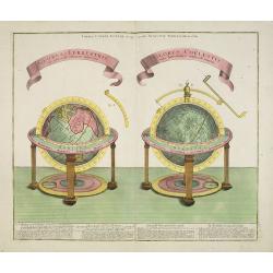
GLOBUS TERRESTRIS ad sphaeram obliquam delineatus. and the GLOBUS COELESTIS cum Astrodictico artificiali iunctus.
A very handsome, large copper engraving of a pair of globes. Ribbon style titles and German text panel at bottom.
- $1000 / ≈ €936
Place & Date: Augsburg, 1774
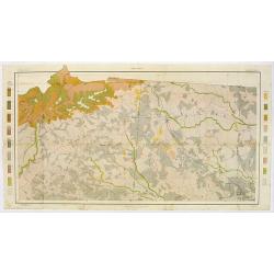
Soil map - South Carolina Campobello Sheet.
Early color lithographed soil map by Julius Bien & Co. in New York for the Department of Agriculture. Legends at the side give detail on soil type, etc. They also inc...
- $50 / ≈ €47
Place & Date: New York, 1903
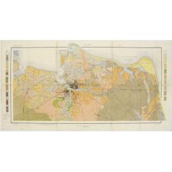
Soil map - Virginia Norfolk Sheet.
Soil map printed by Julius Bien & Co. in New York for the Department of Agriculture. The map gives great detail of the area centered on Norfolk, Potsmouth, Chesapeake...
- $50 / ≈ €47
Place & Date: New York 1903
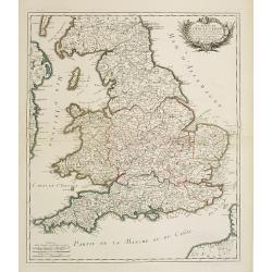
Le royaume d'Angleterre..
Fine map of England and Wales. As well as country details, including the main post roads. Le Rouge was active from 1740- till 1780 as a publisher, and was appointed engin...
- $250 / ≈ €234
Place & Date: Paris, 1745
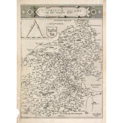
Bitvrigvm, provinciae que Berry.
A rare and beautifully engraved map from the second edition of De Jode's atlas "Speculum Orbis Terrarum". Includes the Loire Valley, centered on Bourges and Vie...
- $200 / ≈ €187
Place & Date: Antwerp, 1593
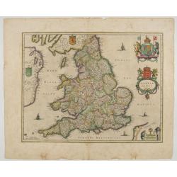
Anglia Regnum.
Janssonius' map of England and Wales was one of the new maps prepared by him in 1636. His map closely copies the similar map issued two years earlier by Willem Blaeu.. Th...
Place & Date: Amsterdam, 1642
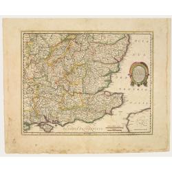
Warwicum Northamtonia Huntingdonia Cantabrigia..
Showing the south-eastern part of England.
Place & Date: Amsterdam, 1642
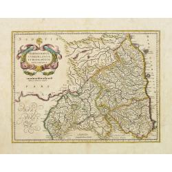
Northumbria, Cumberlandia et Dunelmensis Episcopatus..
Showing the most northern part of England, including Sunderland.
- $400 / ≈ €374
Place & Date: Amsterdam, 1642
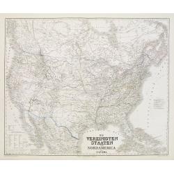
Die Vereinigten Staaten von Nordamerika (Ostlicher theil).
This is a 1876 example of C. Graf's map of the United States of America. The map covers the eastern part of the United States from eastern Texas to the Atlantic, extendin...
- $300 / ≈ €281
Place & Date: Weimar, 1876
Die Vereinigten Staten von Nordamerika nebst Canada.
Large and very detailed German map issued prior to the outbreak of the Civil War. It covers the United States with parts of Canada and Mexico. The states and territories ...
- $400 / ≈ €374
Place & Date: Weimar, 1874
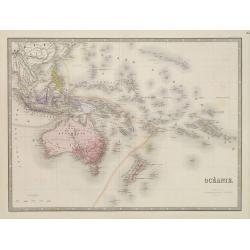
Océanie.
Detailed map of Australia, New Zealand, Indonesia and the Pacific. With a color key indicating English, French, Dutch, Spanish and Portuguese possessions in the region. F...
- $100 / ≈ €94
Place & Date: Paris, 1865
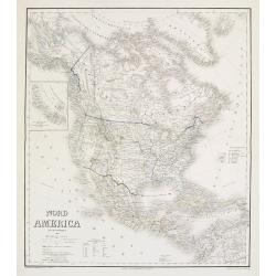
Nord America mit Westindien.
Detailed map of North America. With a color key indicating US, English, French, Dutch, Spanish, Portuguese, Danish possessions in the region with original outline color d...
- $300 / ≈ €281
Place & Date: Weimar, 1874
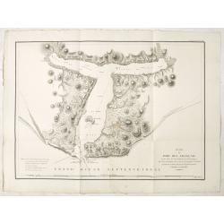
Plan du Port des Francais sur la Cote du Nord-Ouest de l'Amerique, par 58°37' de Latitude Nord et 139°50' de Longitude Occidentale, Decouverte le 2 Juillet 1786, par les Fregates Francaise la Boussole et l'Astrolabe.
Chart of the entrance of Bassin de L'Quest , visited on July 2nd 1786 by La Perouse. On many 18th century maps we find a depiction of Mer de L'Quest or Sea of the West a ...
- $500 / ≈ €468
Place & Date: Paris, 1798
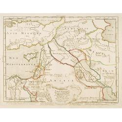
Carte générale pour servir à l'Intelligence de..
Fine map of the Middle East, including the Holy Land, Cyprus, Iran and Irak, etc.Philippe Buache was one of the most active proponents of the so-called, "school of t...
- $300 / ≈ €281
Place & Date: Paris, 1783

Itinera Varia Auctoris.
From A Natural History of Uncommon Birds, and of some other rare and undescribed Animals, Quadrupeds, Reptiles, fishes, insects, &c.. The map shows Edwards' journeys ...
- $300 / ≈ €281
Place & Date: London, 1746
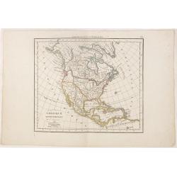
Amérique septentrionale.
A fine map of North America published by the well-known Paris publisher of maps, globes and atlases C.F. Delamarche.
- $110 / ≈ €103
Place & Date: Paris, 1824
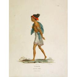
Timor - Malais libre.
A fine color plate from the rare travel book: Voyage de découvertes aux terres Australes . The Baudin voyage from 1800-1804 was the most successful French scientific exp...
- $100 / ≈ €94
Place & Date: Paris, Langlois, 1824
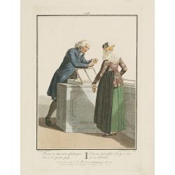
Daar is niet aan aftedingen: het is de gezette prijs.
Fine color plate from "Afbeeldingen van de Kleeding, Zeden en Gewoonten in de BataafscheRepubliek..". A young woman in local dress buying jewellery.Plate number...
- $75 / ≈ €70
Place & Date: Amsterdam, 1804
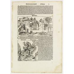
Quarta etas mundi Folium L. ( Jericho, The Prophet Elijah Ascending to Heaven...)
Panoramic view of Jericho. An imaginary view: however, the earliest obtainable view of this period. Underneath The Prophet Elijah Ascending to Heaven in a Fiery Chariot, ...
- $150 / ≈ €140
Place & Date: Nuremberg, 12 July 1493
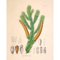
Araucaria brasiliana.
From his famous work "Flora Japonica". Von Siebold was born in Würtzburg, in Germany, and worked for the Dutch government as a doctor in Java. In Japan, where ...
- $75 / ≈ €70
Place & Date: Leiden, 1852
![[Insects]](/uploads/cache/09188-250x250.jpg)
[Insects]
Decorative plate from Naauwkeurige waarneemingen omtrent de veranderingen van veele insekten of gekorvene diertjes. Engraved by Ludwig Schmidt after Jablonsky. Printed by...
- $40 / ≈ €37
Place & Date: Amsterdam, 1774
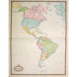
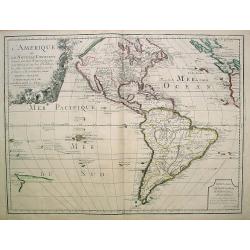
Amérique..
Very detailed map from Atlas Sphéroïdal & Universel de géographie. Prepared by F.A.Garnier and edited by Jules Renouard, rue de Tournon, Paris. With decorative tit...
- $175 / ≈ €164
Place & Date: Paris, 1861
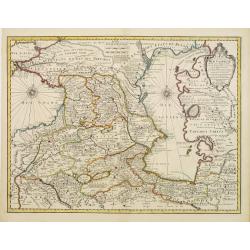
Carte des Pays voisins de la Mer Caspiene. . .
A most attractive and detailed map of the region between the Black and Caspian Seas after De L'Isle. The two Seas are decorated with compass roses. This is one of the few...
- $500 / ≈ €468
Place & Date: Amsterdam, 1720
![[Title page] Table Des Cartes etc: Du Sr. Sanson.](/uploads/cache/09204-250x250.jpg)
[Title page] Table Des Cartes etc: Du Sr. Sanson.
Large, powerfully engraved title page. Geographic scholars at work in a library are depicted along the bottom.Read more about title page [+]
Place & Date: Amsterdam, 1700
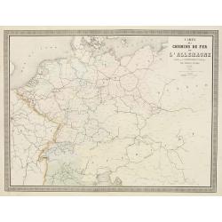
Carte des Chemins de Fer de l'Allemagne.
Fine map of Germany, The Netherlands and Eastern Europe, showing the early railway system of the area. From Atlas des Chemins de Fer published by Napoléon Chaix and pri...
Place & Date: Paris, 1863
Selling price: $2
Sold in 2011

Novissima Flandriae Comitatus tabula. . .
Rare issue of Theodorus Danckert's attractive map of eastern Belgium provinces, Flanders, with Brugge, Oostende, Gent, Mons, Antwerp, Cambray, etc..Decorative title carto...
Place & Date: Amsterdam, 1700
Ducatus Lutzenburgi Nova et Accurataa Tabula. . .
Rare issue of Justus Danckert's attractive map of Luxembourg. Decorative title cartouche lower left hand corner.
- $450 / ≈ €421
Place & Date: Amsterdam, 1700
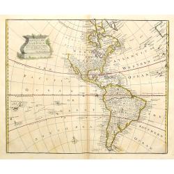
A new general map of America drawn from several..
Extremely faint strip of age toning on part of the centerfold, otherwise fine condition. The Pacific Northwest is left open with the note Parts Undiscovered. The coastlin...
- $500 / ≈ €468
Place & Date: London, 1747
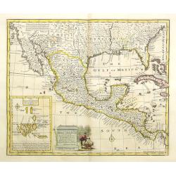
A new and accurate map of Mexico or New Spain with California New Mexico . . .
With inset of Galapagos islands. A wonderfully engraved map showing the entire American South from Carolina to California, as well as all of Mexico and Central America. A...
- $1100 / ≈ €1029
Place & Date: London, 1747

A new & accurate map of Louisiana, with part of Florida. . .
An English view of North America compiled from available French maps, especially those of Bellin used in Charlevoix's History of New France. English cartographers had lit...
- $1000 / ≈ €936
Place & Date: London, 1744
L'Amerique ou le Nouvelle Continent.. Dedieé et presenteé a monseigneur Law.
State one. The map has been prepared by Jean Baptiste Nolin (the elder) has a dedication to Monseigneur LAW controlleur general des finances .Rare general map of the Amer...
- $2200 / ≈ €2059
Place & Date: Paris, 1720

Amerique Septentrionalis..
A handsome map showing California as an island, open-ended Great Lakes and other details based mainly on Sanson. A large decorative cartouche occupies the area of the nor...
Place & Date: Paris, after1694
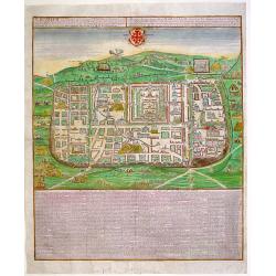
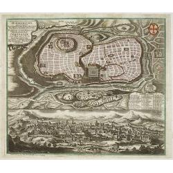
JERUSALEM, cum suburbiis..
Bird's eye perspectives town-plan of Jerusalem. Lower part of print an extensive numbered key (1-254) to principal buildings in town. Title in Latin and German. The print...
- $2250 / ≈ €2105
Place & Date: Augsburg, 1740
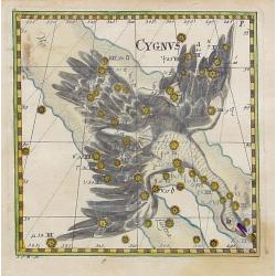
Cygnus.
Uncommon celestial print of Cygnus, published by Corbinianus Thomas in the Manuductio ad Astronomiam, Juxta modum Bayeri, Mathematici celeberrimi, concinnata, multis,…e...
- $350 / ≈ €328
Place & Date: Frankfurt & Leipzig, c.1730
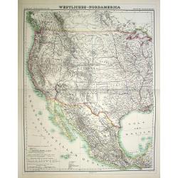
Westliches-Nordamerica.
Large and detailed map of North America. With color key in lower left.The map is prepared by H.Kiepert and published in Berlin by Dietrich Reimer. Engraved by C.L.Ohmann.
- $200 / ≈ €187
Place & Date: Weimar, 1874
Östliches Nordamerica. . .
Large and detailed map of North America. With inset map lower right of ""Die Nordöstlichen Staten"". With color key in lower left.The map is prepared...
- $200 / ≈ €187
Place & Date: Weimar 1874
Prospectus Sanctae olim.. Hierosolymae.. Jerusalem. . .
Two bird's eye perspectives views of Jerusalem. Each with an extensive numbered key to principal buildings in town. Title in Latin and German. The print is published by M...
- $3000 / ≈ €2807
Place & Date: Augsburg, 1740
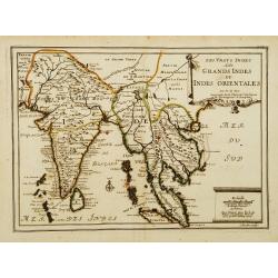
Les Vrays Indes dits Grands Indes ou Indes Orientales Par N. de Fer. Geographe de Sa Majeste Catoliques et de Monseigneur le Dauphin.
Detailed map on India, Thailand, the Malay Peninsular and the south coast of China up to Macao. The map was engraved by C. Inselin.
- $300 / ≈ €281
Place & Date: Paris, 1703

Plan du Golfe et des Caps de St. Tropez. par Jacques Ayrouard . . .
Large plan of the harbour St. Tropez. Decorated with a large compass rose.From the rare chart book by Jacques Ayrouard: "Recueil de plusieurs plans des ports et rade...
- $300 / ≈ €281
Place & Date: Marseille, 1732-1746
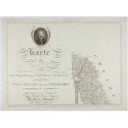
Karte von Ost-Preussen nebst Preussisch Litthauen und West-P
The title section of this important multi-sheet map of Prussia, Lithuania and Poland, showing territories of present Lithuania. With a medallion representing the King of ...
- $250 / ≈ €234
Place & Date: Berlin, 1802

Paradigma XV Provinciarum et CLV Urbium Capitalium Sinensis Imperij Cum Templis quae Cruce X Signatur Et Domiciliis S.I.
First edition of this rare Jesuit map of China, published by Jean Baptiste Nolin in Paris and based on Philippe Couplet's map of 1686. The map shows China's 15 provinces ...
- $2400 / ≈ €2246
Place & Date: Paris, 1686
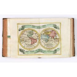
Almanach géographique ou petit atlas élémentaire composé de Cartes générales et particulières des différens Empires, Royaumes et Républiques de l'Europe. . .
Charming almanac with two engraved dedication and title page, portrait of Christian VII. Roy de Dannemarck et de Norvège.The map of Asia is of interest for the use of Ko...
- $3000 / ≈ €2807
Place & Date: Paris, 1770