Browse Listings
Tabula X. Asiae hae sunt e cognitis totius orbis.
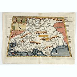
The earliest printed representation of India west of the Ganges River in Ptolemy's time. Considerable detail of river systems and mountain ranges.The first issue of this...
- $1000 / ≈ €936
Place & Date: Lyons, M. Servetus, 1525
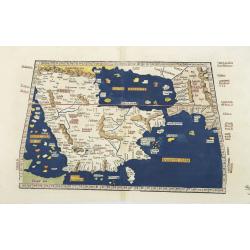
Tabula Sexta Asia (Arabian Peninsula)
This is a very desirable early Ptolemaic woodblock map of the Arabian Peninsula, here called Arabia Felix. The map is presented on a trapezoidal projection with paralle...
- $2200 / ≈ €2059
Place & Date: Strassburg, 1525
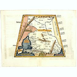
Tabula I Asiae.
Ptolemaic map of Turkey.From Lorenz Fries' edition of Ptolemy's Geographia, largely based on the 1513 map by Waldseemuller. "The elaborate Renaissance woodcut panels...
- $750 / ≈ €702
Place & Date: Vienna, 1490, 1535
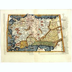
Tabula II Asiae.
A striking example of this wood-cut map depicts north of the Black Sea and west of the Caspian Sea (Ukraine, Russia, Georgia and Armenia). Ptolemy collected his data arou...
- $550 / ≈ €515
Place & Date: Lyons, 1535
![Tabula IIII Aphricae. [with Prester John]](/uploads/cache/42945-250x250.jpg)
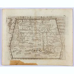
Tabula IIII Aphricae. [with Prester John]
Early Ptolemaic woodcut map of the regions of Africa that were known to the ancients. The twin lake sources of the Nile are located near the Mons Lune (Mountains of the M...
- $950 / ≈ €889
Place & Date: Vienna, 1522- 1535

.Tabu nova partis Aphri.
Based on Waldseemüller's map. The maps show Northern Africa as it was known to Europeans at the first part of the 16th century. There is great details across north Afric...
Place & Date: Lyons, M. Servetus, 1535
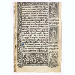
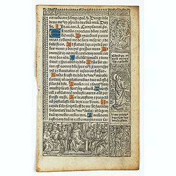
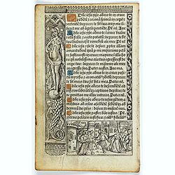
Leaf on vellum from a printed Book of Hours.
21 lines of printed text, surrounded by Renaissance borders decorated with flowers, vases and persons in Medieval dress.From the press of the leading Parisian publisher a...
- $125 / ≈ €117
Place & Date: Paris, Germain Hardouyn, c. 1520-1540
Leaf on vellum from a printed Book of Hours In Latin and French.
24 lines of printed text, surrounded by renaissance borders decorated with flowers, vases and figures. Gothic type, text in Latin, numerous one and two-line initials in g...
- $75 / ≈ €70
Place & Date: Paris, Germain Hardouyn, c. 1520-1540
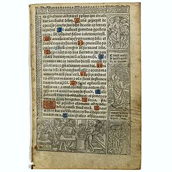
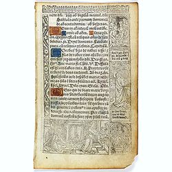
Leaf on vellum from a printed Book of Hours.
24 lines of printed text, surrounded by Renaissance borders decorated with flowers, vases, skeletons and religious scenes.From the press of the leading Parisian publisher...
- $150 / ≈ €140
Place & Date: Paris, Germain Hardouyn, c.1520-1540
Leaf on vellum from a printed Book of Hours.
24 lines of printed text, surrounded by renaissance borders decorated with flowers, vases and religious scenes.From the press of the leading Parisian publisher and illumi...
- $150 / ≈ €140
Place & Date: Paris, Germain Hardouyn, c.1520-1540
Leaf on vellum from a printed Book of Hours.
24 lines of printed text, surrounded by renaissance borders decorated with flowers, vases and religious scenes.From the press of the leading Parisian publisher and illumi...
- $125 / ≈ €117
Place & Date: Paris, Germain Hardouyn, c.1520-1540
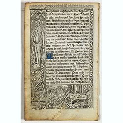
Leaf on vellum from a printed Book of Hours.
21 lines of printed text, surrounded by renaissance borders decorated with flowers, vases and religious scenes.From the press of the leading Parisian publisher and illumi...
- $125 / ≈ €117
Place & Date: Paris, Germain Hardouyn, c.1520-1540
Leaf on vellum from a printed Book of Hours.
21 lines of printed text, surrounded by Renaissance borders decorated with flowers, vases and religious scenes.From the press of the leading Parisian publisher and illumi...
- $125 / ≈ €117
Place & Date: Paris, Germain Hardouyn, c.1520-1540
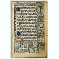
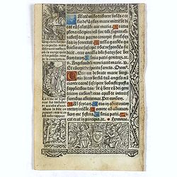
Leaf on vellum from a printed Book of Hours.
21 lines of printed text, surrounded by Renaissance borders decorated with flowers and little miniatures with figures on both sides.From the press of the leading Parisian...
- $125 / ≈ €117
Place & Date: Paris, Germain Hardouyn, c. 1520-1540
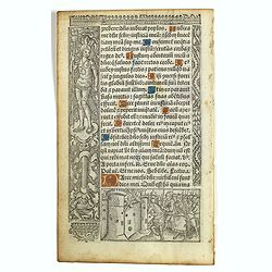
Leaf on vellum from a printed Book of Hours.
21 lines of printed text, surrounded by renaissance borders decorated with flowers, vases and religious scenes.From the press of the leading Parisian publisher and illumi...
- $125 / ≈ €117
Place & Date: Paris, Germain Hardouyn, c.1520-1540
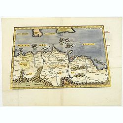
![[Arabian Peninsula]](/uploads/cache/33869-250x250.jpg)
[Arabian Peninsula]
Wood block printed map and one of earliest printed representation of the Arabian Peninsula prepared by Martin Waldseemüller. Based on the slightly larger map from 1513 p...
- $2200 / ≈ €2059
Place & Date: Vienna, Trechsel, G., 1525 -1541
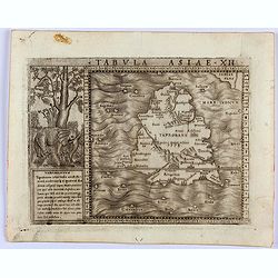
![Tabula XII - Asiae [Taprobana Ins]](/uploads/cache/40249-250x250.jpg)
Tabula XII - Asiae [Taprobana Ins]
Map of Taprobana (Sri Lanka) which depicts the typical misconceptions of Ptolemy showing the island greatly enlarged, surrounded by imaginary islands, and with a small pa...
Place & Date: Vienne, 1541
.Aphricae Tabula secunda continet.
An important early map of the northern coast of Africa and including parts of the islands of Sicily and Sardine.
Place & Date: Vienne, 1541
![[Map of Turkey]](/uploads/cache/31502-250x250.jpg)
[Map of Turkey]
Page with an early representation of Turkey with Cyprus and Syria. This text page with a fine wood block printed map is from the rare work "C. Iulii Solini Polyhisto...
- $275 / ≈ €257
Place & Date: Basle, Michael Isengrin, 1544
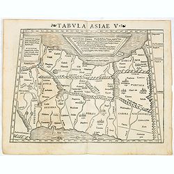
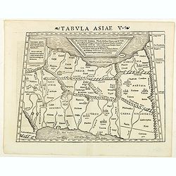
Tabula Asiae V (Persia)
The first edition of Munster's map between the Persian Gulf and the Caspian Sea, extending from Armenia and Mesopotamia eastward, based upon Claudius Ptolemy which appear...
- $300 / ≈ €281
Place & Date: Basel, Heinrich Petri, 1545
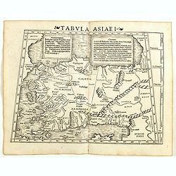
Tabula Asiae I (Turkey)
The first edition of Munster's map of Turkey, based upon Claudius Ptolemy which appeared in his "Geographia Universalis", first published in 1540. The Geographi...
- $500 / ≈ €468
Place & Date: Basel, Heinrich Petri, 1545
Tabula Asiae V. (Persia)
The first edition of Munster's map between the Persian Gulf and the Caspian Sea, extending from Armenia and Mesopotamia eastward, based upon Claudius Ptolemy which appear...
- $300 / ≈ €281
Place & Date: Basel, Heinrich Petri, 1545
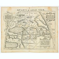
Tabula Asiae VII (Central Asia and Russia)
The first edition of Munster's map of the region north and east of the Black Sea and Caspian Sea, extending to the Imaus Mountains, based upon Claudius Ptolemy which appe...
- $400 / ≈ €374
Place & Date: Basel, Heinrich Petri, 1545
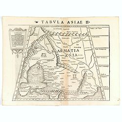
Tabula Asiae II (Black Sea and Caspian Sea).
The first edition of Münster's map of Ukraine and the region north of the Black Sea, based upon Claudius Ptolemy which appeared in his "Geographia Universalis"...
- $400 / ≈ €374
Place & Date: Basel, Heinrich Petri, 1545
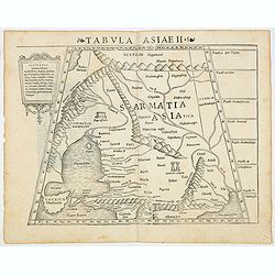
Tabula Asiae II (Black Sea and Caspian Sea)
The first edition of Munster's map of Ukraine and the region north of the Black Sea, based upon Claudius Ptolemy which appeared in his "Geographia Universalis",...
- $500 / ≈ €468
Place & Date: Basel, Heinrich Petri, 1545
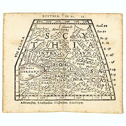
Scythia.
Woodblock engraved map covering the region between the Caspian and the Sea of China, much of which is Terra Incognita in the North and East. In 1546 Honter’s Cosmograph...
- $190 / ≈ €178
Place & Date: Zürich, 1546
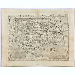
Tabula Europae II. (Spain and Portugal)
Gastaldi's map showing Spain and Portugal, based upon Ptolemy.It is one of the earliest obtainable maps of the region.From Giacomo Gastaldi's Atlas of 1548 which has been...
- $375 / ≈ €351
Place & Date: Venice, 1548

Tabula Asiae IIII. (Cyprus, Holy Land, Syria, Jordan, Iraq)
Gastaldi's map showing Cyprus, the Holy Land, Syria, Jordan and Iraq, based upon Ptolemy's map It is one of the earliest obtainable maps of the region.From Giacomo Gastal...
- $350 / ≈ €328
Place & Date: Venice, 1548
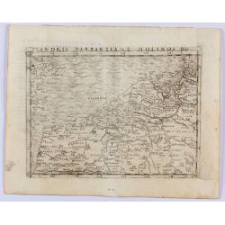
Flandria Barbantia e Holanda No.
Gastaldi's modern map of the Low Countries of the Netherlands, Belgium and Luxembourg. It includes parts of England, France and Germany.According to van der Heijden This ...
Place & Date: Venice, 1548
Selling price: $450
Sold in 2021
Tabula Asiae I.
Gastaldi's map of Asia Minor and the Bosporus Straits, based upon Ptolemy.It is one of the earliest obtainable maps of the region .From Giacomo Gastaldi's Atlas of 1548 w...
- $400 / ≈ €374
Place & Date: Venice, 1548
Tabula Africae IIII.
Gastaldi's map of the Northern Africa, based on Ptolemy. Showing all of the Mediterranean, Ethiopian Interior, the Red Sea, Egypt, the source of the Nile, Red Sea, Dead S...
- $400 / ≈ €374
Place & Date: Venice, 1548
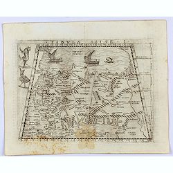
Tabula Asiae XII. (Sri Lanka)
Gastaldi's map showing Sri Lanka, based upon Ptolemy's twelfth map of Asia depicting Taprobana. With a decorative scene with elephant and descriptive text next to the map...
- $350 / ≈ €328
Place & Date: Venice, 1548
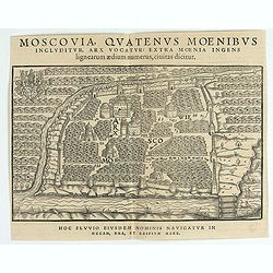
Moscovia Sigismundi Liberi Baronis In Herberstein, Neiperg et Gutehnag Anno M.D XLIX
The forst modern plan of Moscow. A rare and important cornerstone map for Russia collections.Sigismund von Herberstein made two visits to Russia. In 1517-18 he travelled ...
- $3000 / ≈ €2807
Place & Date: Vienna, 1549
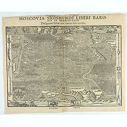
Moscovia Sigismundi Liberi Baronis In Herberstein, Neiperg et Gutehnag Anno M.D XLIX
First Modern Map of Russia. A rare and important cornerstone map for Russia collections.Sigismund von Herberstein made two visits to Russia. In 1517-18 he travelled as a ...
- $3000 / ≈ €2807
Place & Date: Vienna, 1549
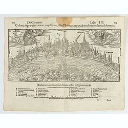
Colonia Agrippina civitas…
A wood block printed early panoramic view of Cologne (Germany). A lettered key A-Z beneath the view. The 1552 Latin text edition of Münster's Cosmographia is a short and...
- $70 / ≈ €66
Place & Date: Basel, 1552
![[Lot of 25 leaves of Africa and Egypt]](/uploads/cache/48275-250x250.jpg)
[Lot of 25 leaves of Africa and Egypt]
Twenty-five text leaves with wood block illustrations relating to Africa and Egypt illustrated with maps, animals, plants.... From the 1552 Latin text edition of Münster...
- $100 / ≈ €94
Place & Date: Basel, 1552
![[Lot of 7 leaves] Curiensis civitas, Rhetorum…/Valesia/Solothurensis/Clarissimae civitatis/Genevensis/Basiliensis/Ursina…Bernensis/Sedunensis/Designatio …Badensis.](/uploads/cache/48278-250x250.jpg)
[Lot of 7 leaves] Curiensis civitas, Rhetorum…/Valesia/Solothurensis/Clarissimae civitatis/Genevensis/Basiliensis/Ursina…Bernensis/Sedunensis/Designatio …Badensis.
Seven text leaves illustrated with wood block bird's-eye views of Chur, Solothurn, Geneva, Basel, Bern, Sitten, Baden and one single sheet map of the Valais. From the 155...
- $400 / ≈ €374
Place & Date: Basel, 1552
![[Lot of 25 leaves of France, Brabant, Netherlands, Luxemburg]](/uploads/cache/48264-250x250.jpg)
[Lot of 25 leaves of France, Brabant, Netherlands, Luxemburg]
Twenty-five text leaves with wood block illustrations relating to France, Brabant, the Netherlands, Luxemburg. From the 1552 Latin text edition of Münster's Cosmographia...
- $100 / ≈ €94
Place & Date: Basel, 1552
![[Lot of 2 leaves] Vienna Austriae metropolis, urbs…](/uploads/cache/48268-250x250.jpg)
[Lot of 2 leaves] Vienna Austriae metropolis, urbs…
A wood block printed early panoramic view of Vienna (Austria). From the 1552 Latin text edition of Münster's Cosmographia, which is a short and complete summary of Renai...
- $50 / ≈ €47
Place & Date: Basel, 1552
![[Lot of 8 leaves relating to the Holy Land]](/uploads/cache/48279-250x250.jpg)
[Lot of 8 leaves relating to the Holy Land]
Eight printed text leaves with maps and views relating to the Holy Land. From the 1552 Latin text edition of Münster's Cosmographia, which is a short and complete summar...
- $100 / ≈ €94
Place & Date: Basel, 1552