Browse Listings in Asia > Thailand / Burma / Vietnam
![XX. Festum Regis in Pegu Solenne. [The king of Pegu's festival]](/uploads/cache/29796-250x250.jpg)
XX. Festum Regis in Pegu Solenne. [The king of Pegu's festival]
The king of Pegu's festival. In Pegu there are many festivals. The most important one is known as Sapan Giachie. On that day, the king appeared, dressed in the most festi...
- $100 / ≈ €87
Place & Date: Frankfurt, 1599
![XXI. Festorum Quorundam Aliorum in Pegu. (Other festivities in the kingdom of Pegu]](/uploads/cache/29797-250x250.jpg)
XXI. Festorum Quorundam Aliorum in Pegu. (Other festivities in the kingdom of Pegu]
Among their many festivals, the Peguans had a particular one called Sapan Daiche – the Festival of Water. The king arrived at a certain place where everyone sprinkled e...
- $100 / ≈ €87
Place & Date: Frankfurt, 1599
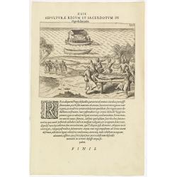
XXII. Sepulturae Regum et Sacerdotum in Pegu delineatio. (The funerals of kings and priests in Pegu)
When a king dies, his friends call for a special boat. This is a kind of double boat, like a catamaran, with a gilded roof overhead, under which is a gilded framework upo...
- $100 / ≈ €87
Place & Date: Frankfurt, 1599
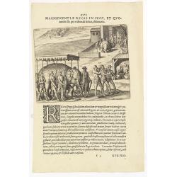
XVI. Magnificentiae Regis In Pegu, et Quomodo. . .
A scene in the kingdom of Pegu, now Myanmar, shows elephants, ships, and locals. Theodore de Bry, a German engraver and book dealer, began a compilation of early voyages ...
- $75 / ≈ €65
Place & Date: Frankfurt, 1599
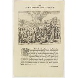
XVII. Proditorum in Pegu Supplicium.
Human torture in Pegu, now Myanmar. After his stay in the Indian city of Goa, Van Linschoten set out for Europe with a Portuguese return fleet in 1588. One of the ships w...
- $75 / ≈ €65
Place & Date: Frankfurt, 1599

Le Roy de Camboia est le Seig.r de touts les Costes de Malabares, et des terres que le Fleuve Indus. . .
Very rare and decorative costume plate. Underneath the plate a descriptive text in French.Bears the address : A Paris chez F. Jollain l aine Rue St Jacques a la Ville de ...
- $200 / ≈ €174
Place & Date: Paris, ca. 1685-1705
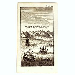
Perspective des Isles de Palo Condoro à le regarde de 8 lieües di coté de Midy.
An attractive view of the Isle de Condor (Côn Son Island), located off the southern tip of Vietnam and a victualing point by European traders. In 1702, the English East ...
- $150 / ≈ €130
Place & Date: Paris / Amsterdam, ca 1730
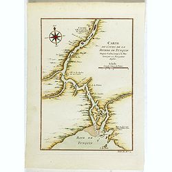
Carte du Cours de la riviere de Tunquin . . .
Map of the Tunquin Riviera. Across the top is an extensive list of 22 important sites and locations keyed to the plan with tiny letters and numbers.Jacques Nicolas Bellin...
- $200 / ≈ €174
Place & Date: Paris, 1750
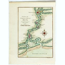
Carte du Cours du Menam . . .
Map of the Menam Riviera. Across the top is an extensive list of 22 important sites and locations keyed to the plan with tiny letters and numbers.Jacques Nicolas Bellin (...
- $200 / ≈ €174
Place & Date: Paris, 1750
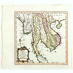
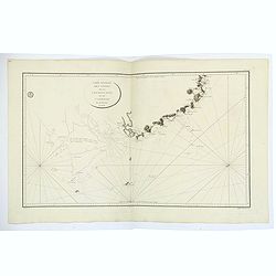
Carte des Royaumes de Siam, du Tunquin, Pegu, Ava, Aracan . . .
Map of Siam, du Tunquin, Pegu, Ava, Aracan. Across the top is an extensive list of 22 important sites and locations keyed to the plan with tiny letters and numbers.Jacque...
- $350 / ≈ €304
Place & Date: Paris, 1750
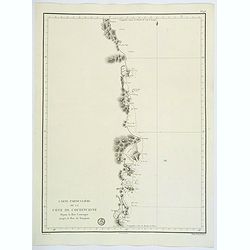
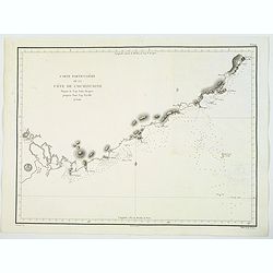
Carte Particuliere de la Cote de Cochinchine Depuis la baie Camraigne jusqu'a le baie de Tamquam.
A basic coastal sea chart of a part of French Indochina (Vietnam) from Cap Varella and Cam Ranh Bay in the south, northward past Nha Trang, Hen Kohe Bay, on to Phu-yen Ba...
Place & Date: Paris ca 1780
Carte Generale des Cotes de la Cochinchine et du Camboge.
A large, double-page French sea chart of part of the southern Cambodian coastline, and from Vietnamese Saigon up to Vung-Tau, Cap Varella, Cam Ranh Bay and Nha Trang. Wit...
Place & Date: Paris, 1780
Carte Particuliere de la Cote de Cochinchine Depuis le cap Saint Jacques jusqu'au Faux Cap Varelle.
This is an impressive 1830 example of the French Depot-General de la Marine nautical chart or maritime chart of the southern coast of Vietnam. The chart extends from Saig...
Place & Date: Paris, 1830
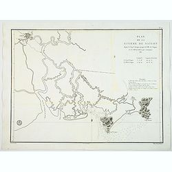
Plan de la Riviere de Saigon depuis le cap St. Jacques jusqu'a la Ville de Saigon.
A chart showing the twists and turns of the Saigon River between Saigon and Cap St. Jacques, produced and published by the Depot General de la Marine in Paris. During 14t...
Place & Date: Paris, ca 1830
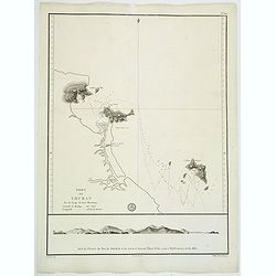
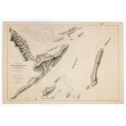
Port de Touran. . .
A large sea chart produced and published by the Depot General de la Marine in Paris. It shows the Port of Touran (modern day Da Nang) in Vietnam. Located on the coast of ...
Place & Date: Paris, ca 1830
Plan de la rivierè de Saigon et de ses affluents dressé par ordre de M. le capitaine de vaisseau d'Ariès, gouverneur de Saigon, d'après les documents fournis par MM. Lespès. . .
A huge folded map the Saigon river prepared after Léo de Lespès, Rieunier Narac. Inset map of "Carte de Banc de Corail, levée d' après les ordres de Mr. le Capta...
- $750 / ≈ €651
Place & Date: St Joseph, Saigon, after 1860
Mer de Chine. Golfe du Tonkin. Entrées de Kuaï-Chin-Mun et Tsieng-Mun. . .
Large chart centred on the Gulf of Tonkin in the South China Sea. Showing banks, isles and soundings made in metres. Relief is shown by hachures.Engraved by A. Gérin aft...
Place & Date: Paris, 1887
Selling price: $300
Sold in 2008
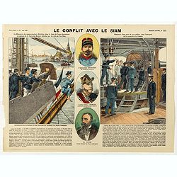
Le conflit avec le siam. (N°195)
Broad sheet relating to The Franco-Siamese War of 1893, a conflict between the French Third Republic and the Kingdom of Siam. Auguste Pavie, French vice consul in Luang P...
Place & Date: Epinal, ca. 1900
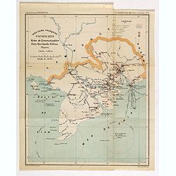
Indo-Chine Française Cochinchine. Voies de Communication Ports Marchants, Défense Phares.
Charming map of the southern third of current Vietnam whose principal city is Saigon or Prey Nokor in Khmer. It was a French colony from 1862 to 1954.Prepared by R.Brissa...
- $150 / ≈ €130
Place & Date: Saigon, Librairie Brunet. c.1920
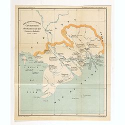
Indo-Chine Française Cochinchine. Productions du Sol Commerce, Industrie.
Charming map of the southern third of current Vietnam whose principal city is Saigon or Prey Nokor in Khmer. It was a French colony from 1862 to 1954.Prepared by R.Brissa...
- $150 / ≈ €130
Place & Date: Saigon, Librairie Brunet. c.1920
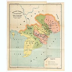
Indo-Chine Française Cochinchine. Carte historique Anciennes Provinces.
Charming map of the southern third of current Vietnam whose principal city is Saigon or Prey Nokor in Khmer. It was a French colony from 1862 to 1954.Prepared by R.Brissa...
- $150 / ≈ €130
Place & Date: Saigon, Librairie Brunet. c.1920
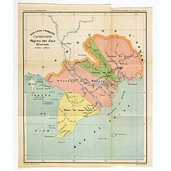
Indo-Chine Française Cochinchine. Régime des Eaux Réseaux.
Charming map of the southern third of current Vietnam whose principal city is Saigon or Prey Nokor in Khmer. It was a French colony from 1862 to 1954.Prepared by R.Brissa...
- $150 / ≈ €130
Place & Date: Saigon, Librairie Brunet. c.1920
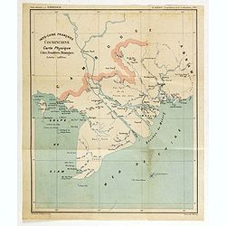
Indo-Chine Française Cochinchine. Carte Physique Côtes, Frontières, Montagnes.
Charming map of the southern third of current Vietnam whose principal city is Saigon or Prey Nokor in Khmer. It was a French colony from 1862 to 1954.Prepared by R.Brissa...
- $150 / ≈ €130
Place & Date: Saigon, Librairie Brunet. c.1920
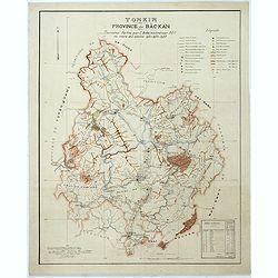
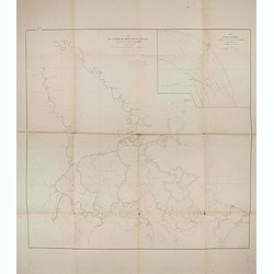
Tonkin Province de Bac-Kan Tournées faites par l'administrateur Blu au cours des années 1921-1922-1923.
Large scale manuscript map (1:200,000) centered on B?c K?n province in the northern region of Vietnam, north of the capital Hanoi.With a key in upper right corner, to the...
- $3000 / ≈ €2604
Place & Date: Hanoï, 1924
l'Indochine Française
Map of Indochina published ca 1937 by Fernand Nathan, a well-known publisher of school books, maps and material for teaching geography.
Place & Date: Paris, ca. 1937
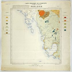
Carte géologique de l'Indochine à l'échelle du 1/500 000e. Pak-Nam Bang-Kok.
Map of Indochina Sheet N ° 16. Covers the area from Paknam (Thailand) to Kompong-Som Bay (Cambodia). On both sides a legend indicates the sedimentary and crystalline lan...
- $130 / ≈ €113
Place & Date: Indo Chine, 1939
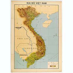
Dia-Do Viet-Nam.
Economic map of Vietnam published in 1960 (not for sale), gift from Japan paper committee. Scale : 1:2 400 000. With a key at lower right part.Features Vietnam, Cambodia,...
Place & Date: 1960
![[US Army map of a part of Vietnam.]](/uploads/cache/44790-250x250.jpg)
[US Army map of a part of Vietnam.]
A large aerial US Army map of a portion of Vietnam, taken during the war between the two countries. As you might expect the map is highly detailed, highlighting settlemen...
- $150 / ≈ €130
Place & Date: Washington D.C., 1967
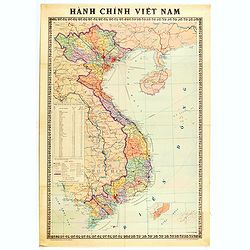
Hành Chính Việt Nam.
Uncommon map of Vietnam published in 1976, one year after the end of the Vietnam War. In April 1976, the National Assembly decided to reiterate Hanoi as the capital of th...
Place & Date: Hanoï, 1976
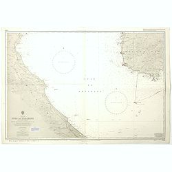
China sea Gulf of Tongking (Southern sheet).
A highly corrected version of Admiralty chart 3989 originally published 11 Mai 1962 under the Superintendence of Captain EG Irving. Detailed chart including the coasts of...
- $80 / ≈ €69
Place & Date: London, 1962 - 1992