Browse Listings in Asia
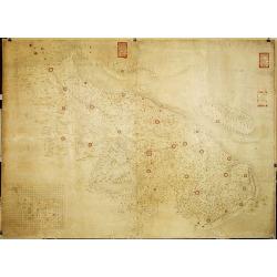
Militairy manuscript map of the end of Yangzi River across Shanghai, Jiangsu, and Zhejiang areas, with 3 red seals of the Ever-Victorious Army.
In lower left corner an inset plan of Songjiang District with Shanghai with a grid and the area is divided with red doted border lines.The map has three red seals of the ...
Place & Date: China, ca 1862
![[Views of Korea, Thailand, Cambodia and its inhabitants and princes. Including one or more phographes by Hippolyte Frandin.]](/uploads/cache/48426-250x250.jpg)
[Views of Korea, Thailand, Cambodia and its inhabitants and princes. Including one or more phographes by Hippolyte Frandin.]
A collection of 95 photographs, of which about 60 photos feature Korea or its people, printed on albumen paper. Captions in French. The others from Thailand, China, India...
- $25000 / ≈ €23393
Place & Date: C. 1892
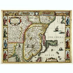
The Kingdome of China.
A most sought-after map of China. Decorative border vignettes including views of the cities of Quinzay and Macao along the top border with the wheeled wind machines and p...
Place & Date: London, G. Humble, 1626
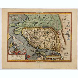
Chinae, olim Sinarum Regionis, nova descriptio. Auctore Ludovico Georgio.
The first map of China ever to appear in a Western atlas, west to the top. The second state with "Las Philipinas" somewhere in 1587 added to the plate. When thi...
- $6000 / ≈ €5614
Place & Date: Antwerp, 1592

Ambassades mémorables de la Compagnie des Indes orientales des Provinces Unies vers les empereurs du Japon.
First edition in French of this important work on Japan, a work whose illustrations "represent a high-water mark in book illustrations of the 17th century" (Lac...
- $5500 / ≈ €5146
Place & Date: Amsterdam, 1680

Carte d'Asie divisée en ses principaux Etats.
Uncommon and decorative "carte à figures" wall map, prepared by Clouet, with superb decoration including a wonderful rococo border with vignettes describing hi...
Place & Date: Paris, Mondhare, 1787
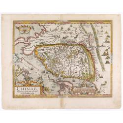
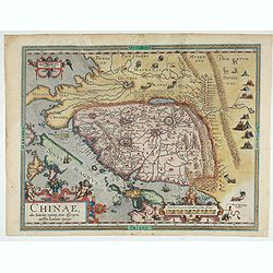
Chinae, olim Sinarum regionis. . .
The first printed map of China. It is signed by Ludovico Georgio, whose real name was Luis Jorge de Barbuda. He was a Portuguese Jesuit cartographer and besides that a sp...
- $6000 / ≈ €5614
Place & Date: Antwerp, 1608
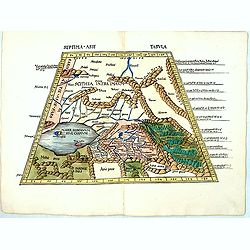
Septima Asie Tabvla.
Trapezoidal woodcut map showing the area around the Caspian Sea from Martin Waldseemüller's most important 1513 edition of Ptolemy, which was a landmark work that contri...
- $6000 / ≈ €5614
Place & Date: Strasburg, J. Schott, 1513
Chinae, olim Sinarum regionis. . .
The first printed map of China. It is signed by Ludovico Georgio, whose real name was Luis Jorge de Barbuda. He was a Portuguese Jesuit cartographer and besides that a sp...
Place & Date: Antwerp, 1598
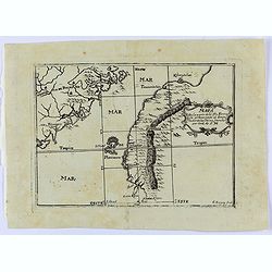
Mapa De la parte de la Isla Formosa sa perteneciente al Emperadotde la China sacado por Ord. De S.M.
Very rare map of Taiwan and the neighboring coastline of China, engraved by Cipriano Bagay in Manila, one of the few maps published in the Philippines in the 18th Century...
- $6000 / ≈ €5614
Place & Date: Manilla, 1788