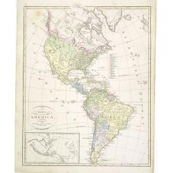
Browse Listings in America
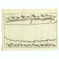
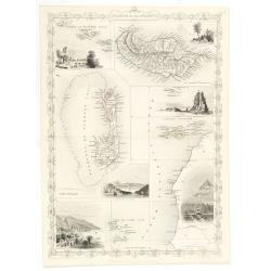
I. S. Sebastien.
Simplified bird's-eye view of Ilha de São Sebastiao, part of an archipelago off the southern coast of Brazil 210 miles from Rio de Janeiro. It was discovered on January ...
- $225 / ≈ €211
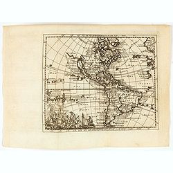
Place & Date: Amsterdam, E. Roger, 1703
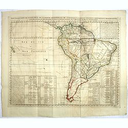
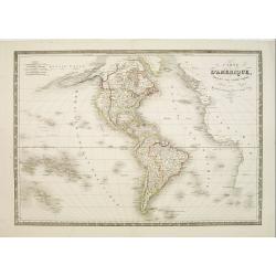
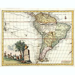
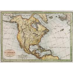
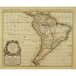
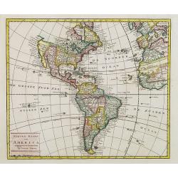
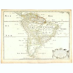
Nouvelle carte de geographie de .. Meridionale de l'Amerique
Chatelain's map of South America. The title is in two lines across the map. The tracks of Magellan, de la Maire, de Mendana, etc. are shown.On each side, borders appear a...
- $250 / ≈ €234
Place & Date: Amsterdam, 1719
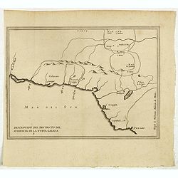
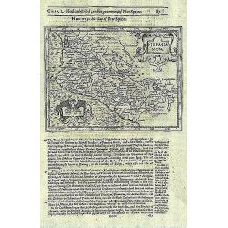
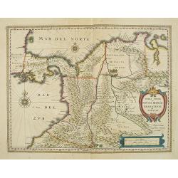
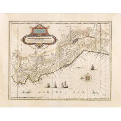
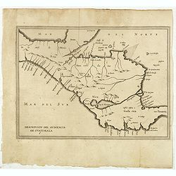
Descripcion del destricto del audiencia de la Nueva Galicia. 5.
The earliest map to include information from the previously secret manuscript maps of the Spanish cosmographer, Juan López de Velasco, showing part of Central America, i...
- $300 / ≈ €281
Place & Date: Amsterdam, Michel Colin, 1622
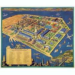
A cartograph of Treasure Island in San Francisco Bay Golden Gate International Exposition.
Ruth Taylor White's large format map of Treasure Island and the San Francisco Golden Gate Exposition Fairgrounds, published in 1940.The map provides an aerial panorama of...
- $200 / ≈ €187
Place & Date: San Francisco, 1940
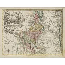
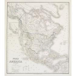
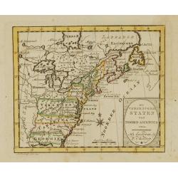
Nov' Orbis Sive America Septentrionalis. . .
Miniature map of North America, a reduction of the appropriate part of Seutter's folio map of the Americas, drawn by Albert Seutter. An unusual looking map, its projectio...
- $250 / ≈ €234
Place & Date: Augsburg, J.M.Will, 1778
![[ North and South America with telegraph cables, with Ottoman script]](/uploads/cache/44330-250x250.jpg)
[ North and South America with telegraph cables, with Ottoman script]
Postcard size map showing North and South America with telegraph cables. The map is in Ottoman Arabic-script prepared by Mehmet EŞREF in a small atlas : عمومولا�...
- $190 / ≈ €178
Place & Date: Istanbul, 1325 or 1909
Carte d'Amerique dressée par Pierre Tardieu. . .
Detailed map prepared by Pierre Tardieu. With good detail on Alaska. Including New Zealand.
- $450 / ≈ €421
Place & Date: Paris, 1831
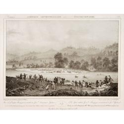
The spot where General Burgoyne surrendered to General Gates.
Decorative print after Jacques Milbert, and lithographed by Sabatier and the figures by Victor Adam.From Amérique Septentrionale. Printed by de Bove and Noöl ainé &...
Place & Date: Paris, 1829
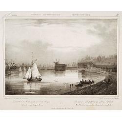
Pierpont's distillery on Long Island.
Decorative print after Jacques Milbert, and lithographed by Sabatier and the figures by Victor Adam.From Amérique Septentrionale. Printed by E.Ardit, Rue Vivienne, Paris...
Place & Date: Paris, 1829
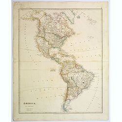
America.
A very nice map of the American continent with California as an island and an adorned title cartouche.From Francisco Giustiniani for El Atlas abreviado o el nuevo compend...
- $300 / ≈ €281
Place & Date: Leon de Francia (Lyon), Jaime Certa, 1739
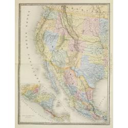
Etats Unis (Etats de l' Ouest).
Large format highly detailed map of the states and territories of the West, with Central America, included in a large inset titled "Etats de l'Amerique Centrale"...
- $400 / ≈ €374
Place & Date: Paris, 1889
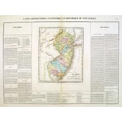
Carte Géographique .. New Jersey.
Detailed map of New Jersey. From J.A. Buchon, Atlas Gégraphique Statistique, historique et chronologique des deux Amériques et des isles adjacentes: traduit de l'atlas ...
- $300 / ≈ €281
Place & Date: Paris, 1825
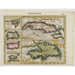
Cuba Insula. Hispaniola.
Decorative engraved map of Cuba above Hispaniola with smaller insets of Havana, Jamaica, Puerto Rico and Margarita.From the first French-text edition of Jodocus Hondius''...
- $300 / ≈ €281
Place & Date: Amsterdam, 1608
Islands in the Atlantic.
Decorative steel engraved map of Islands showing the Azores, Madeira, Bermuda, the Canaries and the Cape Verdes. Interlocking border design. Taken from "The illustra...
- $300 / ≈ €281
Place & Date: London, ca. 1851
Karta öfver America.
An very rare map of the continent of America with Swedish text. This is an heavenly updated version of his map of 1818 and is now dated 1832.From his atlas "Geograph...
- $300 / ≈ €281
Place & Date: A. Wiborgs förlag, Stockholm, ca. 1848
Carta geografica della america meridionale.
Uncommon map of South America based upon Guillaume De L'Isle's map. Includes the routes of early explorers in the Pacific, including Magellan, Drake, Le Maire, Mendana, V...
- $350 / ≈ €328
Place & Date: Venice, 1740
Parte Orientale della Florida, della Giorgia, e Carolina. . .
Attractive map covering the coast from S.Augustine till Long Bay, including Jacksonville, Savannah. From Zatta's Atlante Novissimo.
- $350 / ≈ €328
Place & Date: Venice, 1778
Amérique. . .
Very detailed map from Atlas Sphérodidal & Universel de géographie , Prepared by F.A.Garnier and edited by Jules Renouard, rue de Tournon, Paris. With decorative ti...
- $300 / ≈ €281
Place & Date: Paris, 1861
Hispania Nova.
The rare Samuel Purchas' edition of the Mercator/Hondius Atlas Minor atlas map. This was the standard map of the area for a generation. The map shows an area correspondin...
- $100 / ≈ €94
Place & Date: London, 1625
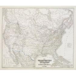
Die Vereinigten Staten von Nordamerika nebst Canada.
Large and very detailed German map issued prior to the outbreak of the Civil War. It covers the United States with parts of Canada and Mexico. The states and territories ...
- $400 / ≈ €374
Place & Date: Weimar, 1874
Nord America mit Westindien.
Detailed map of North America. With a color key indicating US, English, French, Dutch, Spanish, Portuguese, Danish possessions in the region with original outline color d...
- $300 / ≈ €281
Place & Date: Weimar, 1874
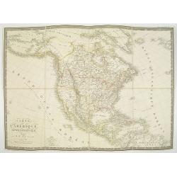
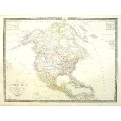
Carte d' Amérique Septentrionale 1817.
Map of North and Central America. Engraved by E.Collin, active at 23, quai des Augustins, Paris.
- $300 / ≈ €281
Place & Date: Paris, 1817
Carte de l'Amerique septentrionale Rédigée par A.H.Brué géographe.
Detailed dissected folding-map of North and Central America by Brué, originally published in Atlas Universel but here mounted on linen and intersected in 8 parts. Next t...
- $250 / ≈ €234
Place & Date: Paris, 1825

Indiana del Perù. / Indienne du Perou.
Portrait of a Peruvian Indian woman holding a fruit basket and a lama in background. From "Raccolta di ? stampe." a series of historically significant eighteent...
- $300 / ≈ €281
Place & Date: Venice, Antonio Zatta, c.1790
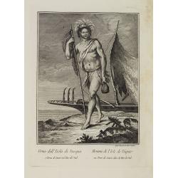
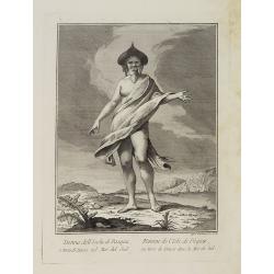
Uomo dell' Isola di Pasqua o Terra di Davis nel Mar del Sud. / Homme de l' Isle de Pâquesou Terra de Davis dans la Mer du Sud.
Full portrait of a native from the Easter Island. From "Raccolta di ? stampe." a series of historically significant eighteenth-century copper plate engravings b...
- $300 / ≈ €281
Place & Date: Venice, Antonio Zatta, c.1790
![Mapa geral do Brasil / organizado pelos J. Carneiro da Silva e Pedro Voss. [Together with] Micro geografia do Brasil. [Together with] Pequeno Mapa do Brasil.](/uploads/cache/45466-250x250.jpg)
Mapa geral do Brasil / organizado pelos J. Carneiro da Silva e Pedro Voss. [Together with] Micro geografia do Brasil. [Together with] Pequeno Mapa do Brasil.
Large folding national map published by "Comp. Melhoramentos de São Paulo Industrias de Papel". Nova edicao revista 1946. Figurs all states. "Futuro Distr...
- $300 / ≈ €281
Place & Date: São Paulo, 1946
Nouvelle carte de l'Amérique Septentrionale et des iles qui en dépendent dressée par H. Brué. . .
Very large, highly detailed, and uncommon issue of the map of North and Central America (ca. 1:13,888,000) prepared by H. Brué and improved by A.Vuillemin. Showing main ...
- $500 / ≈ €468
Place & Date: Paris, 1875
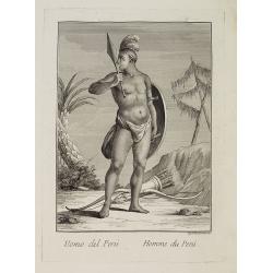
Uomo del Perù. / Homme du Perou.
Full portrait of a Peruvian warrior. From “Raccolta di … stampe.” a series of historically significant eighteenth-century copper plate engravings by Venetian engrav...
Place & Date: Venice, Antonio Zatta, c.1790
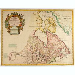
Carte du Canada ou de la Nouvelle France.
Fourth state of the map of Canada published by Delisle with the imprint "sur le Quai de l’Horloge a l’Aigle d’Or avec Privilege pour 20 ans, 1703". Beneat...
Place & Date: Paris, 1703
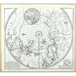
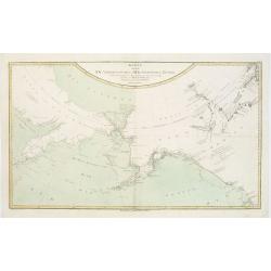
This Draught of the North Pole is to show all the Countries near and adjacent to it . . .
The polar map shows the latest discoveries and routes of numerous explorers during their attempts to find a Northwest and Northeast Passage, including James, Hudson, and ...
- $300 / ≈ €281
Place & Date: London, ca. 1728
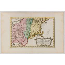
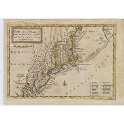
Carte de la Nouvelle Angleterre, Nouvelle York et Pensilvanie / Pour servir à l'Histoire Générale des Voyages.
Uncommon edition of this accurate map the east coast from Delaware River till Main.Left hand corner Lake Ontario. In lower right engraved "38."From Atlas Portat...
- $275 / ≈ €257
Place & Date: Amsterdam, 1773

Missions et Résidences dans la Partie Septentrionale de l'Amérique Contenant 50 Jésuites.
Very rare missionary map of North America from "Atlas Universel indiquant les établissemens des Jésuites: avec la manière dont ils divisent la terre, suivi desév...
- $300 / ≈ €281
Place & Date: Paris, Ambroise Dupont , 1826
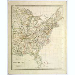
United States.
A lovely large map of the Untied States, as it was at the time of publication. Each state shown in a different outline color. Nothing is shown west of Louisiana, Arkansas...
Place & Date: London, 1839
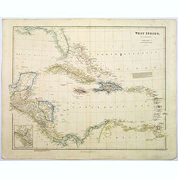
West Indies.
A fine, detailed steel engraved map comprising Florida, Bahamas, Cuba, Haiti, Jamaica, the Windward, and the Leeward Islands, the northern Columbian coastline, Panama, Gu...
Place & Date: London, 1839
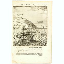
Cocos Eijlandt Isle de Cocos.
Scarce print (193x165mm.) on a French text sheet showing the landing of Le Maire and Schouten at Cocos Island in May 1616 (today’s Tafahi in the Tonga Islands). Named b...
- $245 / ≈ €229
Place & Date: Amsterdam, 1622
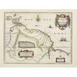
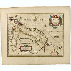
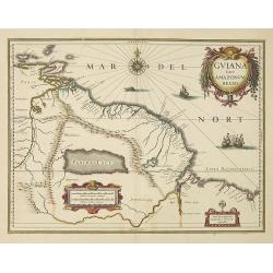
Guiana sive Amazonum Regio.
A very decorative map of Suriname which extends from the Isla Margarita in the northwest to the coast of northern Brazil near Sao Luis east of the Amazon delta. The map l...
- $450 / ≈ €421
Place & Date: Amsterdam, 1658
Neu Engeland Neu York, Neu Jersey und Pensilvanien & c. . .
The scarce German edition of Moll's popular and rather significant map which appeared in Oldmixon's 1708 book, Das Britische Reich in America. and then in other editions ...
- $450 / ≈ €421
Place & Date: Lemgo, 1744
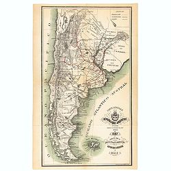
Carte générale de la République Argentine dressée d'après les données les plus récentes.
An UpToDate map of the Argentinian Republic published in Basel by "le Bureau Officiel d'Information de la République Argentine". Detailed map of Argentina show...
- $350 / ≈ €328
Place & Date: Basel, 1887
![[Lot of 5 maps] Kaart van de noord-west kust van Amerika en de noord-oost kust van Asia.](/uploads/cache/19136-250x250.jpg)
[Lot of 5 maps] Kaart van de noord-west kust van Amerika en de noord-oost kust van Asia.
- Kaart van de noord-west kust van Amerika en de noord-oost kust van Asia. Opgenoomen in de Jaaren 1778 en 1779. Captain James Cook (1728-79), explorer, circumnavigato...
Place & Date: Leiden, 1795-1803
Guiana sive Amazonum Regio.
Copper engraving, hand colored in outline when published. A highly decorative map showing Guiana extending westwards to Trinidad and Margarita Island, dominated by a huge...
Place & Date: Amsterdam, 1645
Paraguayo prov. de Rio de La Plata cum regionibus..
A beautiful map of Paraguay, and parts of Peru, Chile, Argentina, Brazil and Bolivia. Much of the area was still "Terra Incognita" so there are few towns and ci...
- $500 / ≈ €468
Place & Date: Amsterdam, 1644
L'Amerique Meridionale Dressée sur les Observations..
Detailed map of South America prepared by De L'Isle, with fine title cartouche.The map is from a Dutch edition of De L'Isle's work entitled, Atlas Nouveau, Contenant Tout...
- $500 / ≈ €468
Place & Date: Amsterdam c. 1745
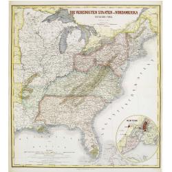
Die Vereinigten Staten von Nordamerika (Ostlicher theil).
Detailed map of eastern part of the United states. In lower right hand corner inset map of New York Bay, including, NY, Newark, Staten Island.The map is prepared by C.Gr�...
- $450 / ≈ €421
Place & Date: Weimar, 1874
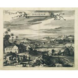
Serinhaim.
Fine view of a fort in Serinhaim, Brazil, with numbered key at the base. A procession of Portuguese or Dutch soldiers advance along the road carrying a litter. To the lef...
Place & Date: London, 1671
L' Amerique divisée par Grands Etats. . .
Attractive map of America, ornated with a decorative title cartouche. Boundaries outlined in hand color.Prepared by Le Sieur Janvier, Jean denis [Robert], French geograph...
- $450 / ≈ €421
Place & Date: Paris, ca 1783
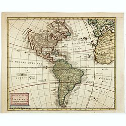
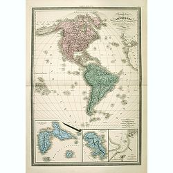
Nieuwe kaart van America.
An attractive map of both the Americas, by one of the leading mapmakers in 18th century Amsterdam. Isaak Tirion (d. 1769) was a Amsterdam publisher. His "Nieuwe en b...
- $400 / ≈ €374
Place & Date: Amsterdam, 1765
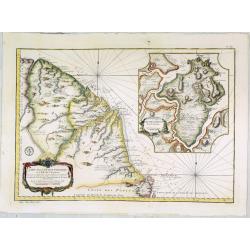
Terra Firma et Novum regnum Granatense et Propayan.
Fine copy, with wide margins of this handsome map of the Isthmus of Panama and northwestern South America including most of present day Columbia and part of Venezuela. Te...
- $400 / ≈ €374
Place & Date: Amsterdam, 1640
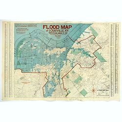
Flood Map of Louisville, KY.
A scarce poster of the great flood of Louisville, KY in 1937. The blue coloring highlights the flooded areas of the city, while the red numbers show the depth of the floo...
- $500 / ≈ €468
Place & Date: Louisville, 1938
Donna dell' Isola di Pasqua, o terra di Davis nel Mar del Sud. / Femme de l' Isle de Pâques ou terre de Davis dans la Mer du Sud.
Full portrait of a woman, a native of the Easter Island. From "Raccolta di ? stampe." a series of historically significant eighteenth-century copper plate engra...
- $350 / ≈ €328
Place & Date: Venice, Antonio Zatta, c.1790
Guiana sive Amazonum Regio.
Willem Blaeu’s decorative map of the Guianas, Lake Parima (Parime Lacus), and the route to El Dorado was initially issued in 1630 (with some variants were published wel...
- $400 / ≈ €374
Place & Date: Amsterdam, 1638
Débarquement sur les iles Powell, le 20 février 1838.
Exquisite contemporary colored lithograph of the Powell islands, situated near the South Orkney Islands, with Dumont D'Urville's officers leaving the island. Drawn by Lou...
- $400 / ≈ €374
Place & Date: Paris, 1848

Région arctique.
Decorative map of the North Pole, prepared by Louis Vivien de Saint-Martin (* 22. Mai 1802 in Saint-Martin de Fontenay, died 3 January 1897 in Paris). He was one of the m...
Place & Date: Paris, Hachette, 1877
![[Set of 2 maps] The Pageant of History in Northern California its colorful and adventuresome beginnings / The Panorama of Today in Northern California its resources, activities and opportunities.](/uploads/cache/48343A-250x250.jpg)
[Set of 2 maps] The Pageant of History in Northern California its colorful and adventuresome beginnings / The Panorama of Today in Northern California its resources, activities and opportunities.
An unusual and attractive pair of lithographed maps, issued by the American Trust Company, in San Francisco on the occasion of its centenary in 1954. It chose to do this ...
- $350 / ≈ €328
Place & Date: San Francisco, 1954
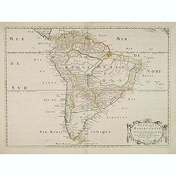
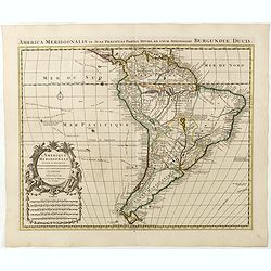
Amerique Meridionale. Par N.Sanson d'Abbeville. . .
The first edition of a cornerstone South America map, the first to show the boundaries of many countries, regions, and provinces. Peru is shown governing a huge tract of ...
- $500 / ≈ €468
Place & Date: Paris, after 1650
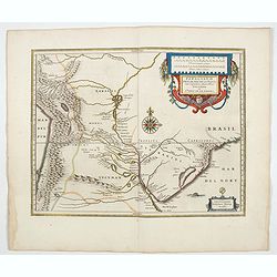
Carte du Paraguay, du Chili, du Detroit de Magellan &c.
Large handsome map of the southern part of the continent with good interior detail for the period. The route of 18th century explorations are shown along with notations c...
Place & Date: Amsterdam c. 1745
America.
A beautiful, large scale map of the Americas. Alaska is named as 'Russian America', Texas is still a part of Mexico, yet to become a republic (1836), before finally becom...
Place & Date: London, 1839

Upper Canada &c.
A beautiful, large scale map of Upper Canada, and portions of the American states of New York, Ohio, and Pennsylvania. The province of 'Upper' Canada was created by the B...
Place & Date: London, 1839
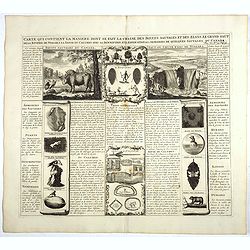
Carte qui contient la manière.. Niagara..
A series of 12 engravings together with descriptive text, derived from the works of Lahontan and Hennepin, illustrating the methods of the Indians hunting buffalo and sim...
Place & Date: The Hague 1720
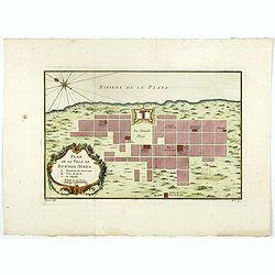
Plan de la ville de Buenos-Ayres.
Early plan of Buenos-Ayres city. Across the top is an extensive list of 22 important sites and locations keyed to the plan with tiny letters and numbers.Jacques Nicolaas ...
- $300 / ≈ €281
Place & Date: Paris, 1750
Nieuwe kaart van America.
An attractive map of both the Americas, by one of the leading mapmakers in 18th century Amsterdam. Isaak Tirion (d. 1769) was a Amsterdam publisher. His "Nieuwe en b...
- $350 / ≈ €328
Place & Date: Amsterdam, 1765
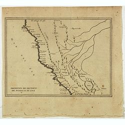
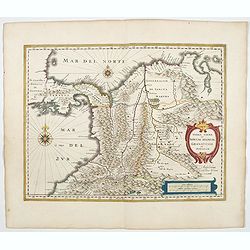
Descripcion Del Destrieto Del Audiencia De Lima. (Peru, and parts of Colombia, and Brazil)
Rare early map of the Audiencia of Lima, locating rivers and settlements, the earliest map to include information from the previously secret manuscript maps of the Spanis...
- $475 / ≈ €444
Place & Date: Amsterdam, Michel Colin, 1622
Nouvelle description de lamerique.
Jollain published this rare map of America in 1667. State 3, with the scale, erased, as it fictitious strait on the west coast of North America which Le Royaume de Quiuer...
- $450 / ≈ €421
Place & Date: Paris, 1667
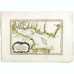
Carte de La Riviere de la Plata . . .
Map of La Plata Riviera. Across the top is an extensive list of 22 important sites and locations keyed to the plan with tiny letters and numbers.Jacques Nicolas Bellin (1...
- $350 / ≈ €328
Place & Date: Paris, 1750
Die Vereinigten Staten von Nordamerika (Ostlicher theil).
Detailed map of eastern part of the United states until the border of Texas. In lower right hand corner inset map of New York Bay, including, NY, Newark, Staten Island.Th...
- $450 / ≈ €421
Place & Date: Weimar, 1874
Peru.
Decorated with ships and monsters on the sea. Orientated with east at the top. Shows the Pacific coast of South America from Ecuador (at the left-hand side) as far south ...
- $400 / ≈ €374
Place & Date: Amsterdam, 1658
Terra Firma et Novum regnum Granatense et Propayan.
Handsome map of the Isthmus of Panama and north-western South America, including most of present day Columbia and part of Venezuela.Terra Firma is Panama, Veragua is Cost...
- $350 / ≈ €328
Place & Date: Amsterdam, ca. 1644
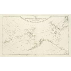
Karte von den N.W. Amerikanische und N.O.E. Asia. . .
German edition of Cook's explorations along the NW Coast of America and NE Coast of Asia, based upon the original work by Lieutenant Henry Roberts.A detailed large-scale ...
- $400 / ≈ €374
Place & Date: Vienna, 1788
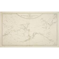
Plan du Port des Francais sur la Cote du Nord-Ouest de l'Amerique, par 58°37' de Latitude Nord et 139°50' de Longitude Occidentale, Decouverte le 2 Juillet 1786, par les Fregates Francaise la Boussole et l'Astrolabe.
Chart of the entrance of Bassin de L'Quest , visited on July 2nd 1786 by La Perouse. On many 18th century maps we find a depiction of Mer de L'Quest or Sea of the West a ...
- $500 / ≈ €468
Place & Date: Paris, 1798
Karte von den N.W.Amerikanische und N.O.E. Asia..
A detailed large-scale map showing the Bering strait, Kamchatka, Alaska, and much of North America. While the Russian coastline is shown with reasonable accuracy. Showing...
- $500 / ≈ €468
Place & Date: Vienna 1788
Carte de la Guyane Françoise et l'Isle de Cayenne..
A well engraved and highly detailed chart of French Guiana and the island of Cayenne. Made in 1763 by Jacques Bellin (1703-72), a prolific cartographer assigned the Minis...
- $500 / ≈ €468
Place & Date: Paris, 1763
L'Amerique Meridionale Dressée sur les Observations . . .
Detailed map of South America prepared by De L'Isle, with fine title cartouche.
- $500 / ≈ €468
Place & Date: Amsterdam, ca. 1745
Nouvelle Carte des Amériques Septentrionale et Meridionale avec les Plans des Possessions Françaises en ces Pays, Rédigée et presentée à l'Académie des Sciences. . .
Large, skillfully engraved, and quite scarce map of North and South America, with insets at bottom of Guadeloupe, Martinique, and Plan de Cayenne. In California, the Sier...
- $450 / ≈ €421
Place & Date: Paris, Garnier Fréres, 1832
![[In Arabic, translates : A map of the United States of America shows its major regional ressources and its natural products]](/uploads/cache/43010-250x250.jpg)
[In Arabic, translates : A map of the United States of America shows its major regional ressources and its natural products]
Chromolithographed pictorial poster of the United States in Arabic language. Showing the United States' main products, regional resources and physical features. The map i...
Place & Date: Washington D.C., ca. 1965
Amerique Meridionale. . . 1650.
First edition. A fine large map of South America, engraved by A.Peyrounin. The relatively unknown Amazon region is left without speculation. However, Sanson includes the ...
- $450 / ≈ €421
Place & Date: Paris, 1650-1659
Descripcion del audiencia de Guatimala 6
The earliest map to include information from the previously secret manuscript maps of the Spanish cosmographer, Juan López de Velasco, showing part of Central America, i...
- $400 / ≈ €374
Place & Date: Amsterdam, Michel Colin, 1622
De vereenigde staten van Noord America.
Rare miniature map of Eastern United States. The map carries the signatures of W.Holtrop and the engraver H.Klokhoff. Steven van Esveldt's business was carried on by his ...
- $450 / ≈ €421
Place & Date: Amsterdam, 1791

Mappa geographica Provinciæ Nova Eboraci ab Anglis New-York . . .
Lower part of the two sheets map of Homann Heirs' edition of Sauthier's celebrated map of New York and New Jersey, made during the Revolutionary War. Appears in Homann's ...
Place & Date: Nuremburg, 1778
Karte von den N.W. Amerikanischen und N.OE. Asiatischen Kusten nach den Untersuchungen des Kapit. Cook...
A detailed large-scale map showing the Bering Strait, Kamchatka, Alaska and much of North America. While the Russian coastline is shown with reasonable accuracy. Showin...
- $450 / ≈ €421
Place & Date: Vienna, 1788
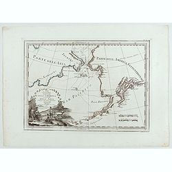
Le Coste Nord Ovest Dell'America e Nord Est dell'Asia Delineate sulle ultime Osservazioni del Cap. Cook
Cassini’s splendid early map of Cook's exploration of the Bering Strait, made on his Third and final voyage. The title is within a decorative title cartouche depicting ...
Place & Date: Rome, Calcography, 1798-before 1839
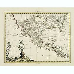
Messico ouvero Nuova Spagna che contiene Il Nuova Messico La California con una Parte de Paesi Adjacenti. . .
Decorative and detailed map of Mexico, Texas, Florida, Louisiana, and Central America. The map is filled with remarkable detail throughout, particularly in Texas, New Mex...
- $475 / ≈ €444
Place & Date: Venise, 1785