Browse Listings in Europe

Woman of Brabant.
Very fine view of a woman wearing the traditional dress of Brabant.
- $150 / ≈ €140
Place & Date: London, 1817
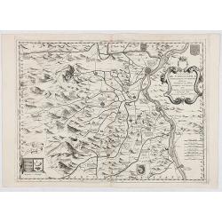
![[Manuscript map, mounted on linen and on rollers]](/uploads/cache/33998-250x250.jpg)
[Manuscript map, mounted on linen and on rollers]
With a title in the upper right corner "Carta geographica generalatus carlostatuensiscum adgacentibus confinis turcicis et venetis martinimis dolmatio istrensibus.&q...
Place & Date: Venice, c. 1700

Oost Zee door Arnold Colom.
Large double-page engraved chart of the Baltic Sea including the coastlines of Finland, Estonia, Latvia, Lithuania, Poland, Denmark and Sweden with a decorative inset of ...
- $1500 / ≈ €1404
Place & Date: Amsterdam, c. 1654
![[Lot of 2 leaves] Rubeaquum cum arce Isenburgo…/ Wyssenburg…](/uploads/cache/48269-250x250.jpg)
[Lot of 2 leaves] Rubeaquum cum arce Isenburgo…/ Wyssenburg…
Two wood block printed early bird's-eye views of Rouffach (lies along the Alsatian wine route) and Wissembourg (Alsace). From the 1552 Latin text edition of Münster's Co...
- $100 / ≈ €94
Place & Date: Basel, 1552
![[Lot of 2 leaves] Vienna Austriae metropolis, urbs…](/uploads/cache/48268-250x250.jpg)
[Lot of 2 leaves] Vienna Austriae metropolis, urbs…
A wood block printed early panoramic view of Vienna (Austria). From the 1552 Latin text edition of Münster's Cosmographia, which is a short and complete summary of Renai...
- $50 / ≈ €47
Place & Date: Basel, 1552
![[Lot of 25 leaves of France, Brabant, Netherlands, Luxemburg]](/uploads/cache/48264-250x250.jpg)
[Lot of 25 leaves of France, Brabant, Netherlands, Luxemburg]
Twenty-five text leaves with wood block illustrations relating to France, Brabant, the Netherlands, Luxemburg. From the 1552 Latin text edition of Münster's Cosmographia...
- $100 / ≈ €94
Place & Date: Basel, 1552
![[Lot of 7 leaves] Curiensis civitas, Rhetorum…/Valesia/Solothurensis/Clarissimae civitatis/Genevensis/Basiliensis/Ursina…Bernensis/Sedunensis/Designatio …Badensis.](/uploads/cache/48278-250x250.jpg)
[Lot of 7 leaves] Curiensis civitas, Rhetorum…/Valesia/Solothurensis/Clarissimae civitatis/Genevensis/Basiliensis/Ursina…Bernensis/Sedunensis/Designatio …Badensis.
Seven text leaves illustrated with wood block bird's-eye views of Chur, Solothurn, Geneva, Basel, Bern, Sitten, Baden and one single sheet map of the Valais. From the 155...
- $400 / ≈ €374
Place & Date: Basel, 1552

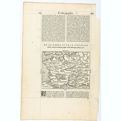
Regionis Biturigum... Per Ioannem Calamaeum. / Limaniae Topographia Gabriele Symeoneo Auct.
Two maps on one sheet. Biturigum. The Loire river is at the right in central France. Neuers (Nevers) is at the middle of the right margin. Bourges is near the center, an...
- $125 / ≈ €117
Place & Date: Antwerp, ca. 1598
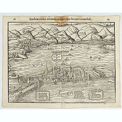
Lindoiae civitas insularis, undique aqua lacunari circunsusa.…
A wood block printed early bird's-eye view of Lindau on Lake Constance (Germany). A lettered key A-O in the plate. From the 1552 Latin text edition of Münster's Cosmogra...
- $70 / ≈ €66
Place & Date: Basel, 1552

Veuë et Pers-pective de l'Entrée du Château de Marly en général.
A rare panoramic view of the Château de Marly (Marly-le-Roi) by Aveline. The plate, at the joint address of Esnault et Rapilly and Daumont, is numbered in upper right co...
- $250 / ≈ €234
Place & Date: Paris, c. 1760

Carte particuliere des costes de Poittou, Aunis et de la Rochelle.
Finely designed and rare map of Isle Ré and the French coast with La Rochelle.
- $1250 / ≈ €1170
Place & Date: Amsterdam, c. 1750
Page from La Cosmographie Universelle with map of France. (Page 160)
Text page with woodblock map of ancient France (122 x 163 mm.) In 1575 Sebastian Münster's Cosmographia was translated into French and published in Paris by François d...
- $75 / ≈ €70
Place & Date: Paris, 1575

Black Sea.
Decorative steel engraved map of the Black Sea with inset views of Sebastopol and Odessa. There are also vignettes of Constantinople, Sinope and Varna. Taken from "T...
- $90 / ≈ €84
Place & Date: London, London Printing and publishing Company of London, ca. 1851
Carte de France corrigée par ordre du Roy sur les observations de Messieurs de l'Académie des Sciences
Important map published by the Academy of Sciences. The new projection method was based on the necessary to define the exact contours of the country and to develop the me...
- $3000 / ≈ €2807
Place & Date: Paris, 1693
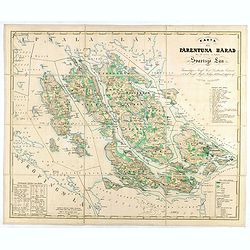
Karta öfver Färentuna härad eller det fordom så kallade Svartsjö län,
Fine and detailed map prepared by Victor Dahlgren (1815-1870).
- $200 / ≈ €187
Place & Date: Stockholm, 1853

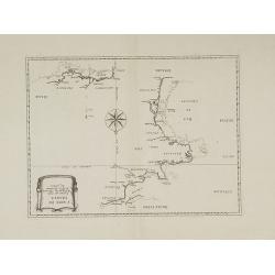
Plan du Golfe et des Caps de St. Tropez. par Jacques Ayrouard . . .
Large plan of the harbour St. Tropez. Decorated with a large compass rose.From the rare chart book by Jacques Ayrouard: "Recueil de plusieurs plans des ports et rade...
- $300 / ≈ €281
Place & Date: Marseille, 1732-1746
Contado DE Venassino, E prencipato d'Oranges . . .
A most attractive and decorative map centered on Avignon and Orange, by Vincenzo Coronelli. An elaborate title cartouche garlanded with intertwined flowers and dedicated ...
- $400 / ≈ €374
Place & Date: Venise 1690
Disegno Idrografico del Canale Reale . . .
A decorative Coronelli map showing the Canal du Midi. It shows the extent of the canal from the Mediterranean sea at Narbonne to Toulouse. Featuring a pair of large coats...
- $300 / ≈ €281
Place & Date: Venice, 1695-1697
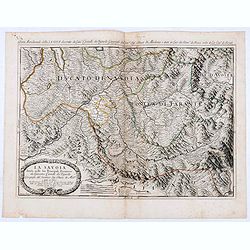
La Savoia divisa nelle sue Principali Provincie da Giacomo Cantelli da Vignola . . .
Late 17th century maps of the Savoy region, based on the reports of Giacomo Cantelli da Vignola and published in Roma in Giacomo de Rossi's world atlas Mercurio Geografic...
- $250 / ≈ €234
Place & Date: Rome, 1692
![[Pictorial map of Georgia (Caucasus)].](/uploads/cache/44292-250x250.jpg)
[Pictorial map of Georgia (Caucasus)].
A scarce pictorial map of a region in Georgia in the Caucasus. Map is entirely in Russian, complete with legend at base of map, with small thumbnail pictures and symbols ...
- $150 / ≈ €140
Place & Date: Moscow, 1963
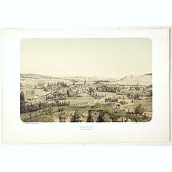
COMMERCY, Vue prise de la Garenne - Chemins de fer de l'Est. Dessiné d'après nat. et Lith. par A.Maugendre.
Original lithograph eye-bird view of Commercy, as seen from La Garenne. Lithographed by Jules Monthelier (1801-1883) and Adolphe-Jean-Baptist Bayot (Alessandria 1810 - 18...
- $125 / ≈ €117
Place & Date: Paris, 1844

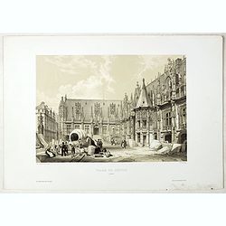
PORTAIL SEPTENTRIONAL DE LA CATHÉDRALE A CHARTRES. Dessiné d'après nature par Monthelier. Lith. par Monthelier.fig. par Bayot.
Original lithograph of the northern portal of Chartres cathedral. Lithographed by Jules Monthelier (1801-1883) and Adolphe-Jean-Baptist Bayot (Alessandria 1810 - 1866) af...
- $75 / ≈ €70
Place & Date: Paris, 1844

ARC DE TRIOMPHE A ORANGE. Dessiné d'après nature par Guesdon. Lith. par Ad. Cuvellier. Fig. par Bayot.
Original lithograph of the Triumph Arc of Orange. Lithographed by A. Cuvillier and Adolphe-Jean-Baptist Bayot (Alessandria 1810 - 1866) after a design by Chapuy and print...
- $100 / ≈ €94
Place & Date: Paris, 1844
PALAIS DE JUSTICE A ROUEN. Dessiné d'après nature par Chapuy. Lith. par Rouargue.
Original lithograph of the courthouse of justice in Rouen. Lithographed by Rouargue after a design by Chapuy and printed in Paris by Lemercier, Bernard Cie.
- $150 / ≈ €140
Place & Date: Paris, 1844

INTERIEUR DE LA CATHEDRALE A CHARTRES. Dessiné d'après nature par Chapuy. Lith. Par Bachelier.
Original lithograph of the inside of the cathedral situated in Chartres. Lithographed by Bachelier after a design by Chapuy and printed in Paris by Lemercier, Bernard Cie...
- $35 / ≈ €33
Place & Date: Paris, 1844

TOMBEAU DU DUC DE BREZE, DANS LA CATHEDRALE DE ROUEN. Dessiné d'après nature par Chapuy. Lith. par Monthelier. Fig. par Bayot.
Original lithography of the tomb of the duke of Brézé, in the cathedral of Rouen. Lithographed by Jules Monthelier (1801-1883) and Adolphe-Jean-Baptist Bayot (Alessandr...
- $50 / ≈ €47
Place & Date: Paris, 1844

ÉGLISE St. VINCENT A ROUEN. Dessiné d'après nature par Chapuy. Lith. par Monthelier. Fig. par Bayot.
Original lithograph of St Vincent cathedral, situated in Rouen. Lithographed by Jules Monthelier (1801-1883) and Adolphe-Jean-Baptist Bayot (Alessandria 1810 - 1866) afte...
- $80 / ≈ €75
Place & Date: Paris, 1844

INTERIEUR DE L'EGLISE SAINT OUEN A ROUEN. Dessiné d'après nature par Chapuy. Lith. Par Arnout. Fig par Bayot.
Original lithograph of the inside of Saint Ouen chruch, situated in Rouen. Lithographed by Arnout and Adolphe-Jean-Baptist Bayot (Alessandria 1810 - 1866) after a design ...
- $50 / ≈ €47
Place & Date: Paris, 1844

FACADE DE LA CATHÉDRALE A CHARTRES. Dessiné d'après nature par Chapuy. Lith. par Deroy.
Original lithograph of Chartres Cathedral's facade. Lithographed by Deroy after a design by Chapuy and printed in Paris by Lemercier, Bernard Cie.
- $125 / ≈ €117
Place & Date: Paris, 1844

ÉGLISE SAINT OUEN, A ROUEN. Dessiné d'après nature par Chapuy. Lith. par Deroy.
Original lithograph of Saint Ouen cathedral, situated in Rouen. Lithographed by Deroy after a design by Chapuy and printed in Paris by Lemercier, Bernard Cie.
- $125 / ≈ €117
Place & Date: Paris, 1844
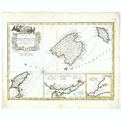
Carte des Isles de Maiorque Minorque et Yvice.
Uncommon map of Majorca, Minorca and Ibiza prepared by J.N. Bellin. With an inset plan of the harbor of Mahon "Plan du Port et de la Ville de Mahon", and a seco...
- $700 / ≈ €655
Place & Date: Nuremberg, 1756

Guide de Florence et de ses environs Redige´ sur un plan entierement nouveau par l'Abbé A. Bulgarini et Traduit en français par A. Le Rendu. Deuxième édition.
Second edition. With 1 engr. folding plan (Pianta della Citta di Firenze. I. Balatri inc. e scris.) and 12 copper plates with views in Florence. The folding plan has meas...
- $550 / ≈ €515
Place & Date: Florence, Gaspard Ricci, 1839
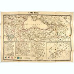
Carte d'Orient par Kraminski ingénieur.
Large map of Orient, with an insert of four maps (Constantinople plan - Map of Europe - Map of Russia - Plan of Baltic sea). With flags in the lower left part. color key ...
Place & Date: Paris, 1854
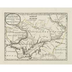
Des Russischen Reiches Statthalterschaften Neurussland, Asow, und das Oestliche Nogay
Map showing Lake Asow and the Crimea. The river Dnepr until Krementschug, and the river Don until Pawlowsk. Published by Franz Johann Joseph von Reilly.
Place & Date: Vienna, 1789
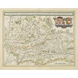
Saltzburg Archiepiscopatus, et Carinthia Ducatus
Handsome map of the archbishopric of Salzburg and the Duchy of Carinthia.Title in banner form with two coats of arms and three cherubs decorating the map.As Willem Blaeu ...
Place & Date: Amsterdam, 1638
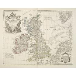
Les Isles Britanniques ou sont le Rme. D'Angleterre . . . Par G. De L'Isle. . . A Paris Chez Dezauche. . .
Uncommon late edition, (dated An 8, 1800 ) of this map of the British Isles prepared by DeL'Isle and published during the French Revolution by Dezauche / Buache. The bott...
Place & Date: Paris, 1800
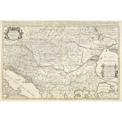
Le Royaume de Hongrie.
Fine oversized map of Hungary, but including Bosnia and Herzegovina, Bulgaria, Croatia, Romania, Albania, European part of Turkey, and Ukraine. With a decorative title an...
Place & Date: Amsterdam, 1692

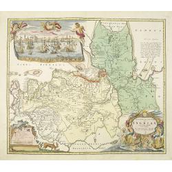
Le Royaume de Boheme, le Duché de Silesie, et les Marquisats de Moravie et Lusace, dresses d'apres les cartes de Muller . .
Map of Poland, Bohemia, Silesia, Moravia and Lusatia. Large decorative title cartouche in upper right. In upper left corner inset plan of Breslau and in lower right a ins...
Place & Date: Paris, 1790
Ingermanlandiae seu Ingriae novissima tabula luci tradita. . .
Detailed map centered on Saint Petersburg. With imposing title cartouche and panoramic view of Saint Petersburg. The map was drawn shortly after the conclusion of the Gre...
Place & Date: Nurenberg, 1780
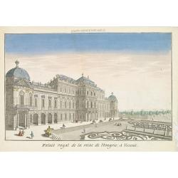
Palais royal de la reine de Hongrie à Vienne.
Perspective view of the royal palace of the queen of Hungry, in Vienna, a well-known publisher of optical prints, established in rue St.Jacques in Paris. With brief key l...
Place & Date: Paris, 1760