Browse Listings
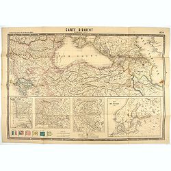
Carte d'Orient par Kraminski ingénieur.
Large map of Orient, with an insert of four maps (Constantinople plan - Map of Europe - Map of Russia - Plan of Baltic sea). With flags in the lower left part. color key ...
Date: Paris, 1854
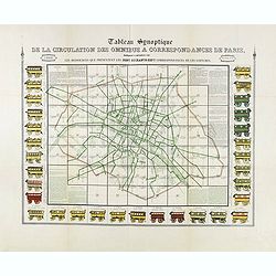
Tableau synoptique de la circulation des omnibus à correspondances de Paris.
Synoptic table of the circulation of omnibuses with connections of Paris indicating at first sight the resources presented by the one hundred and sixty-seven connections ...
- $750 / ≈ €637
Date: Paris, ca. 1854
![[Title page Atlas National Illustré . . .]](/uploads/cache/47736-250x250.jpg)
[Title page Atlas National Illustré . . .]
Title page of Atlas national illustré des 86 département de la France, divisé par arrondissements et en commune by Victor Levasseur in 1854, and published by A. Combet...
- $175 / ≈ €149
Date: Paris, 1854

(Lübeck) Lvbeca vrbs. imperialis libera. civitatvm. Wandalicarvm. . . .
Impressive, more than 3 meters wide panoramic town view after a woodblock engraving from Elias Diebel, initially made in 1552. Of this original woodblock, Bachmann mentio...
Date: Germany, c. 1855

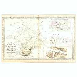
The Crimea by James Wyld Geographer to the Queen & H.R.H. Prince Albert.
Fourth edition of this folding map of the Crimea. In upper right corner an inset map of the areas around the Black Sea; "The Town & Harbor of Sevastopol with the...
Date: London, 1855
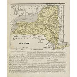
New York.
Map of New York. From Sidney E. Morse''s: System of Geography for the use of schools , published by Harper and brothers, 329 Pearl Street, New York.An 150 years old map w...
- $30 / ≈ €25
Date: New York, 1855
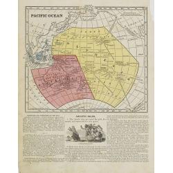
Pacific Ocean.
Map of the Pacific Ocean with its Polynesian islands, and New Zealand and Australia. From Sidney E. Morse''s: System of Geography for the use of schools , published by Ha...
- $30 / ≈ €25
Date: New York, 1855
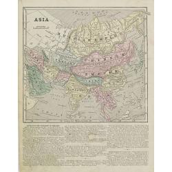
Asia.
Map of Asia encompassing the Russian Empire, the Chinese Empire, India Persia, Tartary, Turkey, and Arabia. From Sidney E. Morse''s: System of Geography for the use of sc...
Date: New York, 1855
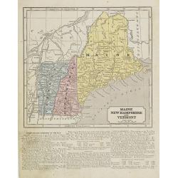
Maine, New Hampshire and Vermont.
Map of Maine, New Hampshire and Vermont.. On the verso, a world map of North and South America with its northern and southern hemispheres. From Sidney E. Morse''s: System...
Date: New York, 1855

Military map of the countries between Odessa & Perekop with the stations of the Russian forces.
Rare colored linen-backed map showing Russian troop positions and Odessa Batteries. On the inside of the cover a list of "Wyld's list of recent publications : seat o...
Date: London, ca. 1855
Accampamenti, Trinceramenti, ed Operazioni di Assedio...
Detailed plan of the Allied siege of Sebastopol in 1854-1855 during the Crimean War, showing the allied French, English and Turkish positions, and those of the Russians, ...
- $400 / ≈ €340
Date: Naples, 1855
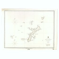
North Pacific Ocean LOO CHOO and adjacent Islands 1855.
Large scale chart of Okinawa in the Japan Sea. With scale and vignette of Typographical office. Map nr. 2416.An interesting note in lower right "The coast line of al...
- $300 / ≈ €255
Date: London, 1855
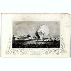
Bombardment of Odessa by the English and French April 22 1854, explosion on the imperial mole . . .
Scene from the Crimea war, showing a bombardment of Odessa, 22nd April 1854 (during Crimean War, 1853-56), by English and French forces, explosion imperial mole (breakwat...
- $55 / ≈ €47
Date: London, 1855
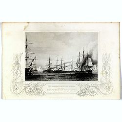
Bombardment of Odessa by the English and French April 22 1854, The boats of the British Fleet going to the French steamer 'Vauban' . . .
Scene from the Crimea war, showing the bombardment of Odessa, 22nd April 1854 (during Crimean War, 1853-56), engraving by G. Greatbach after drawing by H.W. Nicholls, c. ...
- $30 / ≈ €25
Date: London, 1855
Issidori mansiones parthicae a seleucia ad Alexandropolin archosiae.
Map showing Iran and the southern tip of the Caspian Sea. Published in 1855 by Karl Müller as part of his work "Geographi Graeci Minores".Muller wrote in Latin...
- $35 / ≈ €30
Date: Paris, Ambrosio Firmin Didot, 1855

Carte d'unne partie de l'Arabie Septentrionale Pour suivre les Voyages de Mr. G.A. Vallin. . .
This is the original hand-drawn map by Victor Adolphe Malte-Brun of "Carte d'unne partie de l'Arabie Septentrionale Pour suivre les Voyages de Mr. G.A. Wallin",...
Date: Paris, November 1855
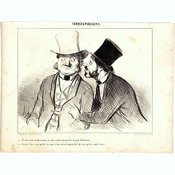
Croquis Parisiens - ''Je suis bien malheureux, si vous voulez me prêter un peu d'attention.... - Je veux bien vous prêter ça, mais il me serait impossible de vous prêter autre chose.''
Second state (of 3), with text. From "Croquis Parisiens". Text below image : "Je suis bien malheureux, si vous voulez me prêter un peu d'attention....&quo...
- $75 / ≈ €64
Date: Paris, after 1855
Croquis Parisiens - ''Je suis bien malheureux, si vous voulez me prêter un peu d'attention.... - Je veux bien vous prêter ça, mais il me serait impossible de vous prêter autre chose.''
Second state (of 3), with text. From "Croquis Parisiens". Text below image : "- Queu poisson!... - Il est tout de même biau... mais y n'doit pas être bon...
- $75 / ≈ €64
Date: Paris, after 1855
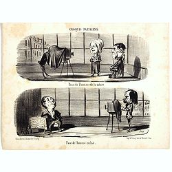
Croquis Parisiens - ''Pose de l'homme de la nature. - Pose de l'homme civilisé.''
Second state (of 3), with text. From "Croquis Parisiens". Text below image : "Pose de l'homme de la nature. - Pose de l'homme civilisé." ( - Pose of ...
- $75 / ≈ €64
Date: Paris, after 1855

Croquis Parisiens - ''Ça sent le jasmin!....... - Ça ne sent pas la violette!......''.
Second state (of 3), with text. From "Croquis Parisiens". Text below image : "- Ça sent le jasmin!....... - Ça ne sent pas la violette!......" ( - I...
- $75 / ≈ €64
Date: Paris, after 1855
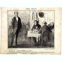
Croquis Parisiens - ''Est-ce le garçon..... faut-il lui demander une assiette? ...''
Second state (of 3), with text. From "Croquis Parisiens". Text below image : "- Est-ce le garçon..... faut-il lui demander une assiette?... - Ma foi, je n...
- $75 / ≈ €64
Date: Paris, after 1855
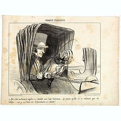
Croquis Parisiens - '' - Qu'a donc ma femme à regarder ce cabriolet avec tant d'attention... je croyais qu'elle ne se connaissait pas en voiture... moi, je n'y trouve rien d'extraordinaire, à ce ...''
Second state (of 3), with text. From "Croquis Parisiens". Text below image : "-- Qu'a donc ma femme à regarder ce cabriolet avec tant d'attention... je cr...
- $75 / ≈ €64
Date: Paris, after 1855

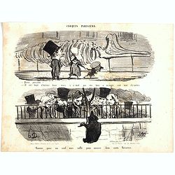
Croquis Parisians - ''A LA RECHERCHE D'UN DINER. - Monsieur ne dine pas chez lei.. - Pas possible!... --- Oh! pour le coup, on dine dans cite Maison ci!
Second state (of 3), with text. From "Croquis Parisiens". Text below image :A LA RECHERCHE D'UN DINER. - Monsieur ne dine pas chez lui.. - Pas possible!... --- ...
- $150 / ≈ €127
Date: Paris, after 1855
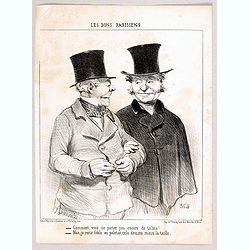
Ces Bons Parisiens - Comment, vous ne portez pas encore de talma? . . . - Non, je reste fidèle au paletot, cela dessine mieux la taille. (364)
Second state (of 2), with text. From "Ces Bons Parisiens". Text below image : - Comment, vous ne portez pas encore de talma. . . . - Non, je reste fidèle au pa...
Date: Paris, after 1855
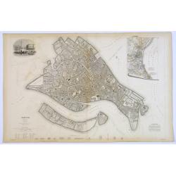
Venice.
A lovely steel engraved plan, on 2 sheets, of Venice by the Society for the Diffusion of Useful Knowledge (SDUK). This English philanthropic enterprise was entirely devot...
Date: London, 1855
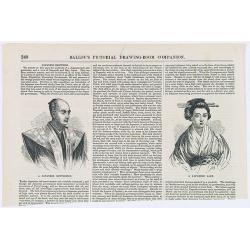
Japanese Sketches.
Two woodcut engravings illustrating a Japanese Gentleman and a Japanese Lady. Included in Ballou's Pictorial.The 1840s~50s saw the rapid growth in popularity of the illus...
- $25 / ≈ €21
Date: Boston, 1856
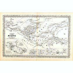
Chart of the Baltic from admiralty & Russian surveys.
Uncommon map of the Baltic Sea and adjacent countries (Denmark, Sweden, Finland, Estonia, Latvia, Lithuania, Poland, Germany) with five vignettes to illustrate the respec...
- $300 / ≈ €255
Date: Pennsylvania, ca. 1856
A Complete Map of the Crimea Showing the Military and Carriage Roads with Distances from Various Points of the Western Coast From English & Russian Surveys. . .
Uncommon map of Crimea with (inset maps) Sebastopol Harbor, and Map Showing the relative Position of the Crimea with the Seat of War. From Desilver's "A New Universa...
- $300 / ≈ €255
Date: Pennsylvania, ca. 1856
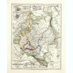
Das Europäische Russland nebst den asiatischen Provinzen diesseit des Ural. 1849.
Detailed map of Russia, with inset plans of St. Petersburg and Moscow with extensive key to the different provinces. The map was according to a text revised in 1856.From ...
Date: Hildburghausen / Philadelphia 1856
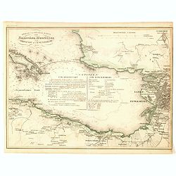
Kriegs- und Spezialkarte vom Finnischen Meerbusen von Kronstadt bis St. Petersburg 1856.
Interesting and detailed map with Kronstadt on the left and St. Petersburg on the right. In the center is information about the war and the listing of some major monument...
- $40 / ≈ €34
Date: Hildburghausen, 1856
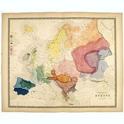
Ethnographic map of Europe by dr. Gustaf Kombst.
Original steel engraving with original hand coloring. A map showing the various ethnicities across Europe with a color key, according to Dr. Gustaf Kombst, published by A...
Date: William Blackwood and Sons, Edinburgh & London, 1856
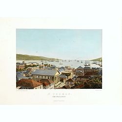
St. Thomas (parti af Byen og Havnen).
A beautiful view of the harbour on the island St. Thomas. This view shows much of the town, bay and surrounding area. One of a series of six lithographs of St. Thomas pro...
Date: Copenhagen, Baerentzen Co, 1856
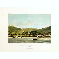
Parti ved Frederikssted (St. Croix).
Early town-views of the small town of Frederiksted on the island of St. Croix. This view shows much of the harbor and a portion of the town's waterfront. one of a series ...
Date: Copenhagen, Baerentzen / Co, 1856
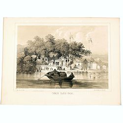
Chinese Temple, Macao.
A pleasant view of the important Chinese Temple in Macao, taken from the water with a junk in the foreground and many sampans and junks moored in front of it, with visito...
- $75 / ≈ €64
Date: Philadelphia, 1856
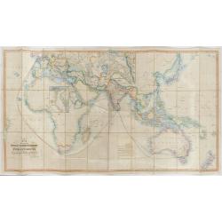
The Pathways of Empire Delineated: Map Showing The Steam Comunication And Overland Routes between England, India, China & Australia…
An illuminating and attractive map that illustrates one of the foundations of British imperial power--the key trade routes by both land and sea between England and its fa...
Date: London, 1856
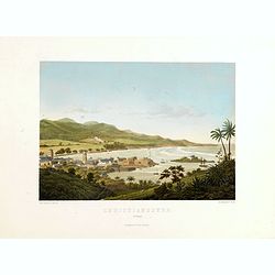
Christianssted. (St.Croix).
A beautiful view of the small town of Christiansted on the island of St. Croix. This view shows much of the harbour and a portion of the town's waterfront. one of a serie...
- $900 / ≈ €765
Date: Copenhagen, Baerentzen & Co, 1856
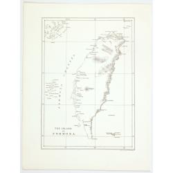
The island of Formosa.
A small, but historically important map of Taiwan (the first American lithograph of Taiwan) made by the American Commodore Matthew C. Perry and published by Ackerman. The...
Date: New York, 1856
The Bucareli Promenade - Paseo de Bucareli - Promenade de Bucareli.
Lithographed plate of the Bucareli Promenade of Mexico City. The plate has caption title in English, Spanish and French, from the rare publication MEXICO Y SUS ALREDEDORE...
Date: Mexico, Establecimiento Litografico de Decaen, 1855-1856

Provincie Noord-Braband. / Breda, de Langstraat. . .
Decorative and uncommon custume plate lithographed by R. de Vries and published by Frans Buffa & Zonen in Amsterdam. A group of 4 women from the area of Baronie van B...
Date: Amsterdam, 1857

Provincie Noord-Braband.
Decorative and uncommon costume plate lithographed by Desguerrois & Co. and published by Frans Buffa & Zonen in Amsterdam. 12 illustrations of Brabant costumes: 1...
Date: Amsterdam, 1857
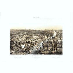
Panorama della Costa e delle Isole di Dalmazia nei viaggi dei piroscafi del Lloyd Austriaco.
On 20 August 1838 the Austrian Lloyd inaugurated a line service from Trieste to the Mouth of Cattaro. In order to illustrate the route, the Company asked the Trieste pain...
- $2500 / ≈ €2125
Date: Trieste, Linassi, 1857
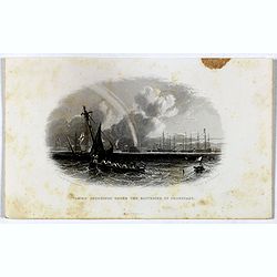
Taking soundings under the batteries of Cronstadt.
Steel engraving showing a small boat taking soundings under the batteries of Kronstadt from a drawing by J. W. Carmichael, engraved by E. Brandard. From "The History...
- $20 / ≈ €17
Date: London, Virtue, ca. 1857
Chart showing the track of the Flagships of the US-Japan Expedition to the eastward of the Cape of Good Hope 1853 & 1854.
A simple sea chart showing the track of the US Steam Frigate Mississippi as she tracked her way from east of Cape Town across the Indian Ocean and the Bay of Bengal, up t...
- $50 / ≈ €42
Date: New York, 1857
The Caspian Sea, Khivah, and the surrounding country compiled from the best sources by John Arrowsmith
This is a very detailed map of the Caspian Sea regions to the north and east. It includes the Caspian Sea, Aral Sea, and the khanate of Khiva, including parts of today's ...
- $450 / ≈ €382
Date: London, 1846-1858
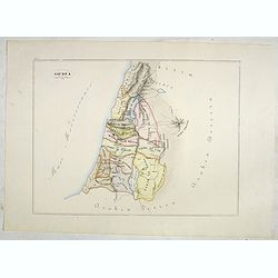
Giudea (Tav I)
A large-format map of the Holy Land with its dioceses. The map is finely engraved and beautifully colored and was prepared by Girolamo Petri, a lawyer who served as a sen...
- $600 / ≈ €510
Date: Rome, 1858
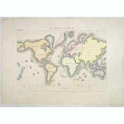
Planisfero (Tav III)
A large-format world map with a key to the steamship routes, telegraph lines and land routes in Europe. Finely engraved and beautifully colored and was prepared by Girola...
Date: Rome, 1858
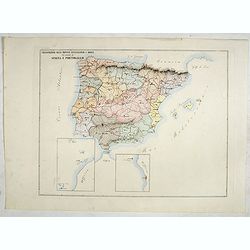
Circoscrizione delle province ecclesiastiche e Diocesinei regni di Spagna e Portogallo (Tav XLVI)
A large-format map of Spain and Portugal with its dioceses. The map is finely engraved and beautifully colored and was prepared by Girolamo Petri, a lawyer who served as ...
- $450 / ≈ €382
Date: Rome, 1858

Circoscrizione delle Provincie ecclesiastiche e Diocesi nei regni del Belgio, ed Olanda (Tav LXI)
This large-format map showing Belgium and Holland with its different dioceses. The map is finely engraved and beautifully colored and was prepared by Girolamo Petri, a la...
Date: Rome, 1858

Provincia ecclesiastica di Malines nel Belgio (Tav LXII)
This large-format map of Belgium with its different dioceses. The map is finely engraved and beautifully colored and was prepared by Girolamo Petri, a lawyer who served a...
Date: Rome, 1858
![[The Netherlands] Provincia ecclesiastica di Utrecht Nell' Olanda (Tav LXIII)](/uploads/cache/44104-250x250.jpg)
[The Netherlands] Provincia ecclesiastica di Utrecht Nell' Olanda (Tav LXIII)
This large-format map of The Netherlands with its different dioceses. The map is finely engraved and beautifully colored and was prepared by Girolamo Petri, a lawyer who ...
- $250 / ≈ €212
Date: Rome, 1858
![[Czech Republic] Provincia ecclesiastica di Praga nell' Impero Austriaco (Tav LXVIII)](/uploads/cache/44108-250x250.jpg)
[Czech Republic] Provincia ecclesiastica di Praga nell' Impero Austriaco (Tav LXVIII)
A large-format map of Czech Republic centered on Prague with its different dioceses. The map is finely engraved and beautifully colored and was prepared by Girolamo Pet...
- $300 / ≈ €255
Date: Rome, 1858
Provincia ecclesiastica di Gnesna e Posnania nella Prussia Vicar.ti apost.cl di Sassonia e Dei Ducati Analtini (Tav LXXXII)
A large-format map of western Poland with its different dioceses. The map is finely engraved and beautifully colored and was prepared by Girolamo Petri, a lawyer who serv...
- $500 / ≈ €425
Date: Rome, 1858
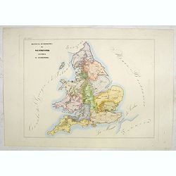
Provincia ecclesiastica di Westminster Londra in Inghilterra (Tav LXXXIV)
A large-format map of the British Isles with its different dioceses. The map is finely engraved and beautifully colored and was prepared by Girolamo Petri, a lawyer who s...
- $300 / ≈ €255
Date: Rome, 1858
![[Scotland] Vicariati Apostolici nella Scozia (Tav LXXXV)](/uploads/cache/44125-250x250.jpg)
[Scotland] Vicariati Apostolici nella Scozia (Tav LXXXV)
A large-format map of Scotland with its different dioceses. The map is finely engraved and beautifully colored and was prepared by Girolamo Petri, a lawyer who served as ...
- $350 / ≈ €297
Date: Rome, 1858
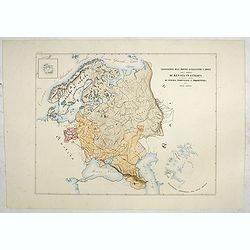
Circoscrizione delle Province ecclesiastiche e Diocesi nelle Impero di Russia in Europa vicariato aplico di Svezia Norvegia e prefettura del Polo Artico (Tav XC)
A large-format map of Sweden, Norway, Russia with its different dioceses. Inset map of Iceland and a North Pole projection. The map is finely engraved and beautifully col...
- $550 / ≈ €467
Date: Rome, 1858
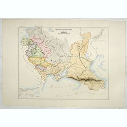
Provincia ecclesiastica di Mohilow nell' Impero Russo (Tav XCII)
A large-format map of Russia, Georgie, Black Sea region with its different dioceses. The map is finely engraved and beautifully colored and was prepared by Girolamo Petri...
- $400 / ≈ €340
Date: Rome, 1858
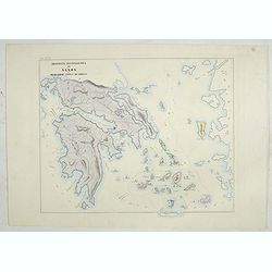
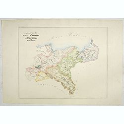
Provincia ecclesiastica di Naxos e delegazione aplica di Grecia. (Tav XCVII)
A large-format map of Naxos with it's dioceses. This Greek island in the South Aegean, is the largest of the Cyclades island group. The map is finely engraved and beautif...
- $250 / ≈ €212
Date: Rome, 1858
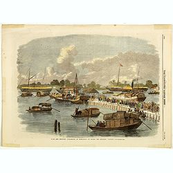
Sick and wounded embarking at Hong-Kong on Board the Steamer.
Large view of the harbour with numerous ships and people. From the Illustrated London News, October 23, 1858.
Date: London, October 1858
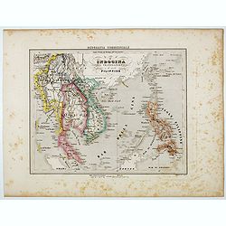
L'Indocina India Transgangetica e le Isole Filippine.
Uncommon map of part of Indo China and the Philippines prepared by Francesco Costantino Marmocchi. Above the map "Geografia Commerciale". From "Il Globo At...
Date: Genova, Paolo Rivara fu Giacomo, 1858
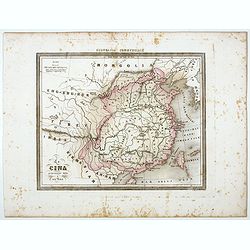
La Cina propriamente detta e sue isole.
Uncommon map of China prepared by Francesco Costantino Marmocchi. Above the map "Geografia Commerciale". From "Il Globo Atlante di carte Geografiche compil...
Date: Genova, Paolo Rivara fu Giacomo, 1858
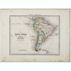
Nuovo Mondo parte Meridionale.
Uncommon map of South America prepared by Francesco Costantino Marmocchi. Above the map "Geografia Commerciale". From "Il Globo Atlante di carte Geografich...
Date: Genova, Paolo Rivara fu Giacomo, 1858
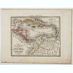
Le Indie Ocidentali ( Antille maggiori e minori, ecc) L'America Centrale . . .
Uncommon map of Central America and the Antilles prepared by Francesco Costantino Marmocchi. Above the map "Geografia Commerciale". From "Il Globo Atlante ...
Date: Genova, Paolo Rivara fu Giacomo, 1858
![[Title page ] Il Globo Atalante di carte geografiche compilate da F.C. Marmocchi per servire di corredo al suo Corso di geografia commerciale.]](/uploads/cache/45291-250x250.jpg)
[Title page ] Il Globo Atalante di carte geografiche compilate da F.C. Marmocchi per servire di corredo al suo Corso di geografia commerciale.]
Title page prepared for Francesco Costantino Marmocchi's Atlas "Il Globo Atlante di carte Geografiche compilate da F.C. Marmocchi per servire di corredo al suo corso...
Date: Genova, Paolo Rivara fu Giacomo, 1858
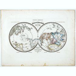
Mappamondo Carta d'Insieme.
Uncommon double hemisphere pole projection prepared by Francesco Costantino Marmocchi. Above the map "Geografia Commerciale". With a color code underneath the m...
Date: Genova, Paolo Rivara fu Giacomo, 1858
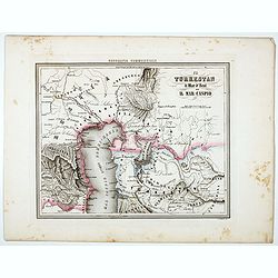
Il Turkestan il Mar d'Aral ed il Mar Caspio.
Uncommon map of Turkestan with the Northern part of the Caspian Sea, with part of present-day Uzbekistan in the lower right corner. in the prepared by Francesco Costant...
Date: Genova, Paolo Rivara fu Giacomo, 1858
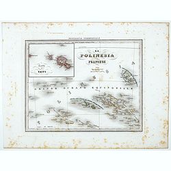
La Polinesia Francese.
Uncommon map of French Polynesia prepared by Francesco Costantino Marmocchi. Above the map "Geografia Commerciale". From "Il Globo Atlante di carte Geograf...
Date: Genova, Paolo Rivara fu Giacomo, 1858
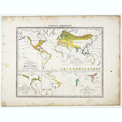
Distribuzione geografica delle Pianta coltivate . . .
Uncommon world map in Mercator projection representing food resources on 3 inset maps, prepared by Francesco Costantino Marmocchi. Above the map "Geografia Commercia...
Date: Genova, Paolo Rivara fu Giacomo, 1858
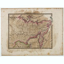
Siberia Occidentale.
Uncommon map of Siberia prepared by Francesco Costantino Marmocchi. Above the map "Geografia Commerciale". From "Il Globo Atlante di carte Geografiche comp...
- $50 / ≈ €42
Date: Genova, Paolo Rivara fu Giacomo, 1858
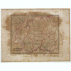
La Siberia Orientale.
Uncommon map of Oriental Siberia prepared by Francesco Costantino Marmocchi. Above the map "Geografia Commerciale". From "Il Globo Atlante di carte Geograf...
- $50 / ≈ €42
Date: Genova, Paolo Rivara fu Giacomo, 1858
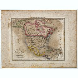
Nuovo Mondo parte Settentrionale.
Uncommon map of North America prepared by Francesco Costantino Marmocchi. Above the map "Geografia Commerciale". From "Il Globo Atlante di carte Geografich...
- $50 / ≈ €42
Date: Genova, Paolo Rivara fu Giacomo, 1858
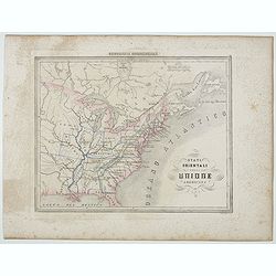
Stati Orientali della Unione Americana.
Uncommon map of Northeastern America prepared by Francesco Costantino Marmocchi. Above the map "Geografia Commerciale". From "Il Globo Atlante di carte Geo...
- $50 / ≈ €42
Date: Genova, Paolo Rivara fu Giacomo, 1858
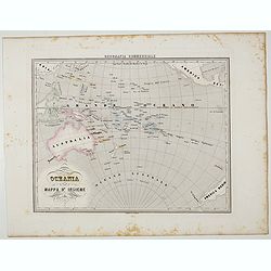
Oceania.
Uncommon map of Pacific ocean prepared by Francesco Costantino Marmocchi. Above the map "Geografia Commerciale". From "Il Globo Atlante di carte Geografich...
- $50 / ≈ €42
Date: Genova, Paolo Rivara fu Giacomo, 1858
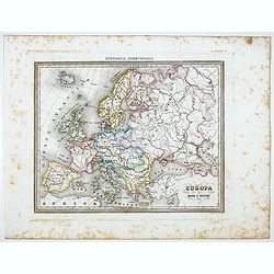
Europa.
Uncommon map of Europe prepared by Francesco Costantino Marmocchi. Above the map "Geografia Commerciale". From "Il Globo Atlante di carte Geografiche compi...
- $50 / ≈ €42
Date: Genova, Paolo Rivara fu Giacomo, 1858
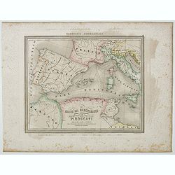
Bacino del Mediterraneo (Parte occidentale) . . .
Uncommon map of Mediterranean Basin prepared by Francesco Costantino Marmocchi. Above the map "Geografia Commerciale". From "Il Globo Atlante di carte Geog...
- $50 / ≈ €42
Date: Genova, Paolo Rivara fu Giacomo, 1858
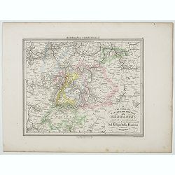
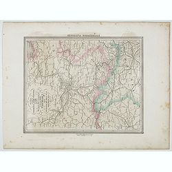
Le Vie Ferrate e le Strade Postali della Germania centrale e meridionale . . .
Uncommon map of Germany and part of France and Switzerland prepared by Francesco Costantino Marmocchi. Above the map "Geografia Commerciale". From "Il Glob...
- $25 / ≈ €21
Date: Genova, Paolo Rivara fu Giacomo, 1858
Le Vie Ferrate e le Strade Postali della Germania orientale . . .
Uncommon map of Germany and part of Poland, Hungary and Italy prepared by Francesco Costantino Marmocchi. Above the map "Geografia Commerciale". From "Il G...
- $25 / ≈ €21
Date: Genova, Paolo Rivara fu Giacomo, 1858
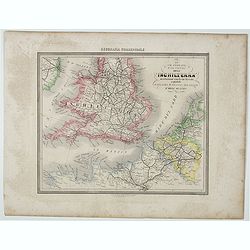
Le Vie Ferrate e Postali dell' Inchilterra . . .
Uncommon map of England and part of France prepared by Francesco Costantino Marmocchi. Above the map "Geografia Commerciale". From "Il Globo Atlante di car...
- $25 / ≈ €21
Date: Genova, Paolo Rivara fu Giacomo, 1858
![[Double-hemispher World Map] Descrizione del Globo in due emisferi . . .](/uploads/cache/44079-250x250.jpg)
[Double-hemispher World Map] Descrizione del Globo in due emisferi . . .
This large-format map is finely engraved and beautifully colored and was prepared by Girolamo Petri, a lawyer who served as a senior official within the Vatican’s State...
- $1750 / ≈ €1487
Date: Rome, 1858
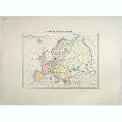
Carta generale di Europa (Tav IV)
This large-format Europe map is finely engraved and beautifully colored and was prepared by Girolamo Petri, a lawyer who served as a senior official within the Vatican’...
- $750 / ≈ €637
Date: Rome, 1858
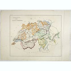
Diocesi della Svizzera (Tav IV)
This large-format Switzerland map is finely engraved and beautifully colored and was prepared by Girolamo Petri, a lawyer who served as a senior official within the Vatic...
- $750 / ≈ €637
Date: Rome, 1858