Browse Listings in Asia
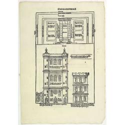
Quinta Etas Mundi. Folium. LXVI. (Visionary Temple of Ezekiel.)
The Latin text page is illustrated with recto and verso depictions of the visionary Temple of Ezekiel. Kings.Page from the richest illustrated Incunable, the famous: Chro...
- $200 / ≈ €187
Place & Date: Nuremberg, 12 July 1493
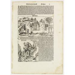
Quarta etas mundi Folium L. ( Jericho, The Prophet Elijah Ascending to Heaven...)
Panoramic view of Jericho. An imaginary view: however, the earliest obtainable view of this period. Underneath The Prophet Elijah Ascending to Heaven in a Fiery Chariot, ...
- $150 / ≈ €140
Place & Date: Nuremberg, 12 July 1493
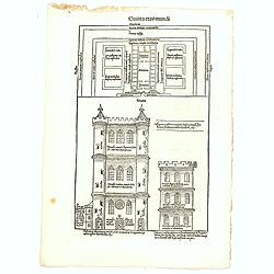
Quinta Etas Mundi. Folium. LXVI. (Visionary Temple of Ezekiel.)
The Latin text page is illustrated with on recto and verso depictions of the visionary Temple of Ezekiel. Kings.Page from the richest illustrated Incunable, the famous: N...
- $200 / ≈ €187
Place & Date: Nuremberg, 12 July 1493

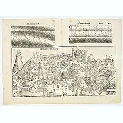
Constantinopolis.
A spectacular woodcut panorama of the ancient city of Constantinople, proporting to show the pre-Turk city (for example naming St Sophia). (235x522mm).One of the earliest...
Place & Date: Nuremberg, 12 July 1493
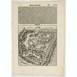
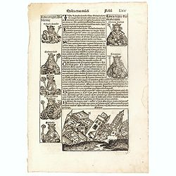
Sexta Etas Mudi. (With view of Sabatz.) Folio CCLIII
A imaginary view of Sabatz, Turkey: however the earliest obtainable view of this period.Further including presentations of the popes Sixtus IV and Innocentius VIII. Pag...
- $200 / ≈ €187
Place & Date: Nuremberg, 12 July 1493
Destruccio Iherosolime.
The view shows the destruction of Jerusalem. Major points in the city are identified with Latin notations. Of interest, in the upper left of the image are two figures...
- $2000 / ≈ €1871
Place & Date: Nuremberg, 12 July 1493
Quinta Etas Mudi. Folium. LXV (With view of Babylon)
The Latin text page is illustrated with an imaginary of the Ancient City of Babylon (Dim. H : 138 mm W : 223 mm).Babylon was the capital of Babylonia, the alluvial plain...
- $150 / ≈ €140
Place & Date: Nuremberg, 12 July 1493
Tercia Etas Mundi. Damascus. / Folio. XXIII
An imaginary presentation of the city of Damascus, the capital of Syria and one of the most ancient cities in the world. An imaginary view: however, the earliest obtainab...
- $600 / ≈ €561
Place & Date: Nuremberg, 12 July 1493
![Constatinopolis. [Istanbul]](/uploads/cache/26996-250x250.jpg)
Constatinopolis. [Istanbul]
Panoramic town-view of Constantinople (Istanbul). Woodcut published in the so-called pirate edition of the "small Schedel" in Augsburg, 1497, Latin edition. Ori...
Place & Date: Augsburg, Johann Schönsperger, 1497
Selling price: $500
Sold in 2009
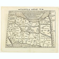
Septima Asie Tabvla.
Trapezoidal woodcut map showing the area around the Caspian Sea from Martin Waldseemüller's most important 1513 edition of Ptolemy, which was a landmark work that contri...
- $6000 / ≈ €5614
Place & Date: Strasburg, J. Schott, 1513

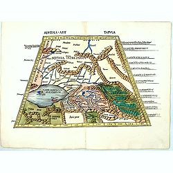
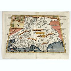
Quinta Asie Tabvla.
Woodblock map of Persia from Martin Waldseemüller's 1513 edition of Ptolemy, a landmark work that contributed to major advances in both Renaissance geography and map p...
Place & Date: Strasbourg, J. Schott, 1513
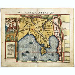
Tabula X. Asiae hae sunt e cognitis totius orbis.
The earliest printed representation of India west of the Ganges River in Ptolemy's time. Considerable detail of river systems and mountain ranges.The first issue of this...
- $1000 / ≈ €936
Place & Date: Lyons, M. Servetus, 1525
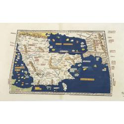
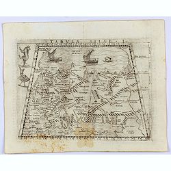
Tabula Sexta Asia (Arabian Peninsula)
This is a very desirable early Ptolemaic woodblock map of the Arabian Peninsula, here called Arabia Felix. The map is presented on a trapezoidal projection with paralle...
- $2200 / ≈ €2059
Place & Date: Strassburg, 1525
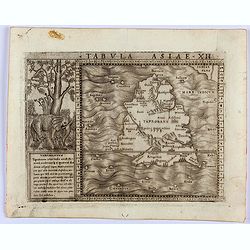
![.Taprobana Ins. Tabula XII Asiae. [Sri Lanka.]](/uploads/cache/27928-250x250.jpg)
.Taprobana Ins. Tabula XII Asiae. [Sri Lanka.]
Ptolemy's mythical island of Taprobana originally became associated with Sri Lanka although it was sometimes confused with Sumatra. Taprobana, as it was called on most ea...
Place & Date: Lyons, M. Servetus, 1535
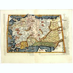
Tabula I Asiae.
Ptolemaic map of Turkey.From Lorenz Fries' edition of Ptolemy's Geographia, largely based on the 1513 map by Waldseemuller. "The elaborate Renaissance woodcut panels...
- $750 / ≈ €702
Place & Date: Vienna, 1490, 1535
![.Tabula III Asiae. [Caucass and Armenia.]](/uploads/cache/27894-250x250.jpg)
.Tabula III Asiae. [Caucass and Armenia.]
Ptolemaic map of the region south of the Caucasus Mountains and between the Caspian Sea as far south as the headwaters of the Tigris River in the south and the Black Sea,...
Place & Date: Lyons, M. Servetus, 1535
![[Map of Palestine ]](/uploads/cache/42176-250x250.jpg)
[Map of Palestine ]
Map of Palestine from "La Mer des Hystoires" published by Dupré, Paris, 1536 "La Mer des Hystoires" is a translation into French of the famous "...
Place & Date: Dupre, Paris, 1536
![.[Pakistan, Afghanistan]](/uploads/cache/33849-250x250.jpg)
.[Pakistan, Afghanistan]
Wood block printed Ptolemaic map of the region of present-day Pakistan and part of Afghanistan. Convoluted mountain ranges and river systems dominate the trapezoidal map....
Place & Date: Vienna, Trechsel, G., 1525 -1541
![[Taprobana - Sri Lanka]](/uploads/cache/33847-250x250.jpg)
[Taprobana - Sri Lanka]
Wood block printed map and one of earliest printed representation of Ceylon prepared Martin Waldseemüller.Based on the slightly larger map from 1513 published in "P...
Place & Date: Vienna, Trechsel, G., 1525 -1541
![.[Near east with Cyprus]](/uploads/cache/33857-250x250.jpg)
.[Near east with Cyprus]
Wood block printed map and one of earliest printed representation of Near east with Cyprus prepared by Martin Waldseemüller. Based on the slightly larger map from 1513 p...
Place & Date: Vienna, 1525 -1541

Tabula Superioris Indiae & Tartariae maioris. (Modern Map of China, Japan, etc.)
Important map extending from Tartary in the north, to "Prov. Bocat" (Cambodia) in the south. "Tebet" is shown prominently, as is "Zinpangri"...
Place & Date: Vienne, 1541
![Tabula XII - Asiae [Taprobana Ins]](/uploads/cache/40249-250x250.jpg)
Tabula XII - Asiae [Taprobana Ins]
Map of Taprobana (Sri Lanka) which depicts the typical misconceptions of Ptolemy showing the island greatly enlarged, surrounded by imaginary islands, and with a small pa...
Place & Date: Vienne, 1541

Tabula nova utriusque Indiae.
This is the fourth and last edition of this map based on Waldseemüller's first "modern" map of Asia. It follows that cartography without change but adds an int...
Place & Date: Vienne, 1541
![.[India]](/uploads/cache/33861-250x250.jpg)
.[India]
Wood block printed map and one of earliest printed representation of India prepared by Martin Waldseemüller. Based on the slightly larger map from 1513 published in &quo...
Place & Date: Vienna, Trechsel, G., 1525 -1541
![.[Bangladesh, Burma, India, Thailand]](/uploads/cache/33867-250x250.jpg)
.[Bangladesh, Burma, India, Thailand]
Wood block printed map and one of earliest printed representation of Bangladesh, Burma, India, Thailand prepared Martin Waldseemüller. Based on the slightly larger map f...
Place & Date: Vienna, Trechsel, G., 1525 -1541
![[Arabian Peninsula]](/uploads/cache/33869-250x250.jpg)
[Arabian Peninsula]
Wood block printed map and one of earliest printed representation of the Arabian Peninsula prepared by Martin Waldseemüller. Based on the slightly larger map from 1513 p...
- $2200 / ≈ €2059
Place & Date: Vienna, Trechsel, G., 1525 -1541
![[East Asia]](/uploads/cache/33873-250x250.jpg)
[East Asia]
Wood block printed map and one of earliest printed representation of East Asia and centered on Amenia, prepared Martin Waldseemüller. Based on the slightly larger map fr...
Place & Date: Vienna, 1525 -1541

Tabula Sexta Asia (Arabian Peninsula)
This is a very desirable early Ptolemaic woodblock map of the Arabian Peninsula, here called Arabia Felix. The map is presented on a trapezoidal projection with par...
Place & Date: Vienna, 1525 -1541
![[India and China]](/uploads/cache/33875-250x250.jpg)
[India and China]
Wood block printed map and one of earliest printed representation of India and China prepared Martin Waldseemüller. Based on the slightly larger map from 1513 published ...
Place & Date: Vienna, 1525 -1541
![[Map of Turkey]](/uploads/cache/31502-250x250.jpg)
[Map of Turkey]
Page with an early representation of Turkey with Cyprus and Syria. This text page with a fine wood block printed map is from the rare work "C. Iulii Solini Polyhisto...
- $275 / ≈ €257
Place & Date: Basle, Michael Isengrin, 1544
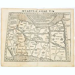
Tabula Asiae V. (Persia)
The first edition of Munster's map between the Persian Gulf and the Caspian Sea, extending from Armenia and Mesopotamia eastward, based upon Claudius Ptolemy which appear...
- $300 / ≈ €281
Place & Date: Basel, Heinrich Petri, 1545
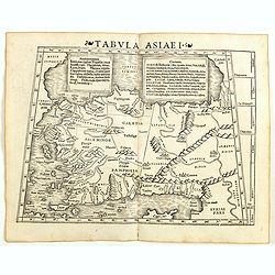
Tabula Asiae I (Turkey)
The first edition of Munster's map of Turkey, based upon Claudius Ptolemy which appeared in his "Geographia Universalis", first published in 1540. The Geographi...
- $500 / ≈ €468
Place & Date: Basel, Heinrich Petri, 1545
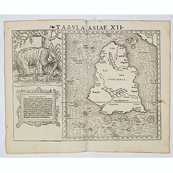
Tabula Asiae XII (Sri Lanka, with Elephant)
The FIRST edition of Munster's first modern map of Sri Lanka, which appeared in his "Geographia Universalis", first published in 1540. The Geographia was a new ...
Place & Date: Basel, Heinrich Petri, 1545
Tabula Asiae V (Persia)
The first edition of Munster's map between the Persian Gulf and the Caspian Sea, extending from Armenia and Mesopotamia eastward, based upon Claudius Ptolemy which appear...
- $300 / ≈ €281
Place & Date: Basel, Heinrich Petri, 1545
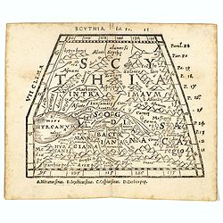
Scythia.
Woodblock engraved map covering the region between the Caspian and the Sea of China, much of which is Terra Incognita in the North and East. In 1546 Honter’s Cosmograph...
- $190 / ≈ €178
Place & Date: Zürich, 1546

Tabula Asiae IIII. (Cyprus, Holy Land, Syria, Jordan, Iraq)
Gastaldi's map showing Cyprus, the Holy Land, Syria, Jordan and Iraq, based upon Ptolemy's map It is one of the earliest obtainable maps of the region.From Giacomo Gastal...
- $350 / ≈ €328
Place & Date: Venice, 1548
Tabula Asiae XII. (Sri Lanka)
Gastaldi's map showing Sri Lanka, based upon Ptolemy's twelfth map of Asia depicting Taprobana. With a decorative scene with elephant and descriptive text next to the map...
- $350 / ≈ €328
Place & Date: Venice, 1548
Tabula Asiae I.
Gastaldi's map of Asia Minor and the Bosporus Straits, based upon Ptolemy.It is one of the earliest obtainable maps of the region .From Giacomo Gastaldi's Atlas of 1548 w...
- $400 / ≈ €374
Place & Date: Venice, 1548
Tabula Asiae XI.
Attractive early woodblock map of the Indian Ocean, extending from Southeast Asia to the Ganges River and north to the Himalayas.In upper left inset panel of tiger, cocke...
- $600 / ≈ €561
Place & Date: Basle, H. Petri, c. 1552

[Lot of 9 leaves with maps and views of Persia and Arabia).
Nineteen text leaves with wood block illustrations relating to Persia and Arabia. From the 1552 Latin text edition of Münster's Cosmographia, which is a short and comple...
- $100 / ≈ €94
Place & Date: Basel, 1552