Browse Listings in Map Types

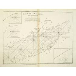
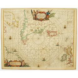
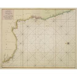
Nieuwe Wassende Graade Zee Kaart over de Spaanse Zee Vant Kanaal tot 't Eyland Cuba in Westindia. . .
¤ Engraved by I.van Anse. A very representative example of a Dutch chart of the Atlantic, showing the north-east coast of America, the coasts of Africa and Europe and So...
Place & Date: Amsterdam, 1728

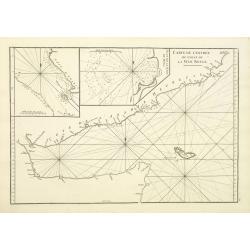
Tractus Littorales Guineae a Promontorio Verde usque ad sinum Catenbelae.
Chart of the West coast of Africa from Mauritania up to Angola. In top centre a very decorative title cartouche.
Place & Date: Amsterdam, 1675

Nova Africa descriptio.
A beautifully engraved and most attractive "carte à figures"- map of the African continent. Bordered, above, by panels showing panorama's of Cairo, Alexandria,...
Place & Date: Amsterdam, after 1660

Noordoost Cust van Asia van Japan tot Nova Zembla.
Important for its early depiction of Hokkaido and the Islands to the North of Japan. Ships navigate the seas around the Siberian, Chinese and Japanese coast extending as ...
- $3000 / ≈ €2807
Place & Date: Amsterdam, 1666

De Texel Stroom .. vant Marsdiep./ Caarte van De Mase...
Two decorative charts on one sheet, one depicting Texel and the entrance of the Zuider Zee with an inset showing the north coast of West-Friesland, the other depicting th...
- $750 / ≈ €702
Place & Date: Amsterdam, 1660

De Tesselstroom met de Gaten van Marsdiep./ De Mase met. . .
Three charts on one sheet depicting the entrances to the Zuiderzee between Holland, Texel and Vlieland. The entrances of the Maas with Rotterdam and in a small inset the ...
- $500 / ≈ €468
Place & Date: Amsterdam, 1662

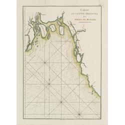
Nieuwe gemeten kaart van de colonie de Berbice : met der zelver plantagien en de namen der bezitters in het ligt gebragt door Reiner & Iosua Ottens kaartverkopers te Amsterdam 1740.
Rare separately published map of the colony of Berbice in present-day Guyana showing the Berbice River Valley and the plantations along the river. North on map of the col...
Place & Date: Amsterdam, 1740

A chart of the northern part of the Indian Ocean..
Chart of the northern part of the Indian Ocean, including part of Arabia, India and Sri Lanka prepared by D'Apré de Mannevillette and published in London by Laurie and W...
- $750 / ≈ €702
Place & Date: London 1794

Manuscript plan of Havana harbour.
Manuscript chart with good nautical detail and soundings of Havana harbour.
Place & Date: Spain c.1820
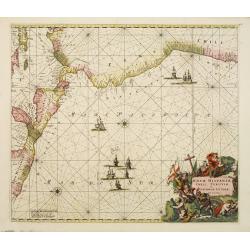
Nova Hispaniae, Chili, Peruviae, et Guatimalae Littorae..
A superbly decorative chart, oriented with north to the left of the sheet, covering the coasts of Central America, Peru, Chile, Jamaica and part of Cuba and Porto Rico. S...
- $1000 / ≈ €936
Place & Date: Amsterdam, 1660

Carte de la Manche. . .
Decorative chart showing the Chanel, with the coastline of France from La Baie de Douarnenez to Dunkerque, and the coastline of England from Stroble head to Manning Tree....
Place & Date: Amsterdam, 1692

Carte de la Baye et du Port de Trinquemalay dans L'Isle de Ceylan.
Chart showing the bay of Trincomalee, Ceylon (Sri Lanka). Trincomalee is natural deep water port on the east coast of Sri Lanka, about 110 miles northeast of Kandy. It is...
- $250 / ≈ €234
Place & Date: Paris, 1775
Carte Plate de la partie Septentrionale du Detroit de Malac, depuis de la rade d'Achem jusqu'a Malac.
French chart of the Island of Sumatra and the Malay Peninsula separated by the strait of Malacca in Indonesia.Latitude and longitude scales, compass rose and system of rh...
- $500 / ≈ €468
Place & Date: Paris, ca. 1775

Les Provinces confederées du Pais-Bas
The first wall map of the Seven Provinces of 1651, re-issued as 'Stoel des Oorlogs' by Covens & Mortier. The first issue of the present wall-map is known to be includ...
Place & Date: Amsterdam, c. 1740
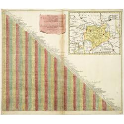
Wegweiser duch das Chiurfurstenthumb Sachen.
Showing distances in-between towns in Saxen, Germany. In upper right hand corner inset map of Saxen, showing Leipzig, Dresden, Prague.More about cartographical curiositie...
- $75 / ≈ €70
Place & Date: Amsterdam 1720

Lion and Bull made of terracotta.
Very fine terracotta figure of a lion symbolizing the continent of Africa. The Bull symbolizing Europe.The items will be dispatched in 4 wooden crates from Belgium. Pleas...
Place & Date: Netherlandisch , 1780~1800

Launa vulgo Laun Bohemiae civitas.
Bird's-eye views of Louny in Bohemia by G. Hoefnagel. The copperplate was made for Braun and Hogenberg's town book. However there the print has been transformed by the en...
Place & Date: The Hague, 1700

Schlanium vulgo Schlani Bohemiae oppidum.
Very decorative and rare panoramic town view of Schlan, Schlanium s. Slany.The engraver and publisher of prints, Mrs. Anna Beek of the Hague, enlarged this print, origina...
Place & Date: The Hague, 1700

Slusa, Teutonicae Flandriae opp. . . (Sluis)
Bird'eye view of the town of Sluis.From the greatest publication in this genre!. The Civitates was compiled and written by George Braun, Canon of Cologne Cathedral. Braun...
Place & Date: Cologne, 1580

Pascaerte van Carybes, Nieu Neder landt, Brazil. . .
This progenitor chart covers the American shores of the Atlantic Ocean. This chart by Theunis Jacobsz. was most probably engraved close to his death in 1650 or shortly af...
- $2200 / ≈ €2059
Place & Date: Amsterdam, 1653-1681
![[East coast of Africa, Arabia and west coast of India.]](/uploads/cache/04762-250x250.jpg)
[East coast of Africa, Arabia and west coast of India.]
Rare. Map of the east coast of Africa, Including Madagascar, the Arabian Peninsular, coast of Pakistan and west coast of India.Prepared by Joao Teixeira in 1649, this cha...
Place & Date: Paris, 1664-1696

.Caarte voor een gedeelte der Canarise Eylanden als Canaria, Tenerifa, Forteventura, etc.
Very rare chart of the Canaries. Showing Palma, Ferro, Tenerife, Gran Canaria, Forteventura, Lancerota. In upper right hand corner inset of harbour of Lancerota.
- $1000 / ≈ €936
Place & Date: Amsterdam, 1666
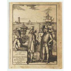
(title page) Description de L'Univers suite de L'Europe ancienne et moderne des terres Australes et de L'Amerique Tome V.
Showing arrival of Francis Drake in the New World.
- $150 / ≈ €140
Place & Date: France, 1683
Carte de la Mer Rouge, depuis Moka jusqu'a Gedda.
Chart of the Red Sea. With 3 inset maps of Shake Omare, Goofs and Gedan.D'Après De Mannevillette (1707-1780) was one of France's first hydrographers. When the first edit...
- $450 / ≈ €421
Place & Date: Paris, 1775

Plan de la Rade de Gedda situee de la Cote d'Arabie sur la Mer Rouge.
Chart of the area around city of Gedda in the Red Sea. D'Après De Mannevillette (1707-1780) was one of Franc's first hydrographers. When the first edition of his Atlas L...
- $600 / ≈ €561
Place & Date: Paris, 1745
Carte de L'entrée du Golfe de la Mer Rouge.
Chart of the Gulf of Aden with the coast line of Yemen, the Island Socotra and the entrance of the Red Sea. With 2 inset charts off-shore of the town Mocha.D'Après De Ma...
- $400 / ≈ €374
Place & Date: Paris, 1753

Hollandia Comitatus.
Orientated west to the top of the sheet, this presents the County of Holland in the classical orientation for seventeenth-century maps, with Amsterdam at the center. The ...
Place & Date: Amsterdam, 1660
(Title page) Principum Christianorum Stemmata.
Uncommon title page. From Antonio Albizzi, "Principum Christianorum Stemmata ab Antonio Albizio Nobili Florentino collecta: et Cum brevibus ejusdem notationibus ex A...
- $200 / ≈ €187
Place & Date: Strasbourg, 1610
![[Titlepage] Nomenclator Ptolemaicus..](/uploads/cache/06436-250x250.jpg)
[Titlepage] Nomenclator Ptolemaicus..
Title page from a Ortelius Atlas part called: Nomenclator , containing a register of place names in antiquity. Letterpress with copper engraved print (60x60mm) of the eas...
- $150 / ≈ €140
Place & Date: Antwerp, 1609
![[Title page] Recueil de tous les Costumes.](/uploads/cache/06437-250x250.jpg)
[Title page] Recueil de tous les Costumes.
Uncommon and decorative title page of a man holding a curtain with title and a woman reading a book. With a dedication to Mr. Bignon, who was librarian of the King of Fra...
- $200 / ≈ €187
Place & Date: Paris, 1779
![[Title page from] Le Theatre du Monde ou Nouvel Atlas.](/uploads/cache/06754-250x250.jpg)
[Title page from] Le Theatre du Monde ou Nouvel Atlas.
Architectural frontage without the usual title and imprint printed on paste-on slips.More about title pages [+]
- $250 / ≈ €234
Place & Date: Amsterdam, 1640
![[Title page] Le Theatre du Monde ou Nouvel Atlas.](/uploads/cache/06812-250x250.jpg)
[Title page] Le Theatre du Monde ou Nouvel Atlas.
Architectural frontage with the title and imprint printed on paste-on slips.The map is in a strictly contemporary coloring and of the highest level.Read more about colori...
- $400 / ≈ €374
Place & Date: Amsterdam, 1640
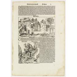
Quarta etas mundi Folium L. ( Jericho, The Prophet Elijah Ascending to Heaven...)
Panoramic view of Jericho. An imaginary view: however, the earliest obtainable view of this period. Underneath The Prophet Elijah Ascending to Heaven in a Fiery Chariot, ...
- $150 / ≈ €140
Place & Date: Nuremberg, 12 July 1493
![[Title page] Table Des Cartes etc: Du Sr. Sanson.](/uploads/cache/09204-250x250.jpg)
[Title page] Table Des Cartes etc: Du Sr. Sanson.
Large, powerfully engraved title page. Geographic scholars at work in a library are depicted along the bottom.Read more about title page [+]
Place & Date: Amsterdam, 1700
Pascaerte van Groen-Landt, Yslandt, Straet Davids en Ian Mayen eylandt. . .
An eye-catching chart of the North Atlantic, showing prominent Greenland, Iceland, and parts of the North American continent. The map is decorated with a large figurative...
- $2000 / ≈ €1871
Place & Date: Amsterdam, 1666

Noordoost Cust van Asia van Japan tot Nova Zemla.
An eye-catching chart of Japan, Hokkaido and the Islands to the North of Japan. In the lower left Korea and part of northern China. Korea has three names mentioned: "...
- $2000 / ≈ €1871
Place & Date: Amsterdam, 1666

Pascaert van Engelant Van t'Voorlandt tot aen Blakeney waer in te sien is de mont vande Teemse.
Two charts on one sheet. One decorative sea chart of the southeast coast of England with an inset of the Thames till London, embellished with two title cartouches, a ship...
- $750 / ≈ €702
Place & Date: Amsterdam, 1666

.Paskaarte om Achter Yrlandt om te Zeylen van Hitlant tot. . .
An eye-catching chart of Ireland, including the north of England and Scotland, with the West to the top.Pieter Goos (ca. 1616-1675) was one of the most important cartogra...
Place & Date: Amsterdam, 1673
![[Titlepage] Germaniae tabule geographicae.](/uploads/cache/12197-250x250.jpg)
[Titlepage] Germaniae tabule geographicae.
Decorative title page to the volume of the "Atlas, Sive Cosmographicae Meditationes De Fabrica Mundi" devoted to maps of Germany. The design in a typical Manner...
- $280 / ≈ €262
Place & Date: Amsterdam, 1630
![[Title page] Schauplatz des gegenwaertigen kriegs. . .](/uploads/cache/12307-250x250.jpg)
[Title page] Schauplatz des gegenwaertigen kriegs. . .
Title page from Schauplatz des gegenwaertigen kriegs. Very fine, typical German title page with cannons, flags, trumpets, etc.Gabriel Nikolaus Raspe (1712-1785) was activ...
- $250 / ≈ €234
Place & Date: Nuremberg, 1757-1764
![Bunken Edo oezu. [Tokyo]](/uploads/cache/12826-250x250.jpg)
Bunken Edo oezu. [Tokyo]
Based on map by Ochikochi Doin. Oriented with north to the right. An extraordinary wood block-printed town-plan now-a-day Tokyo, and a fine example of Edo cartography. Th...
Place & Date: Edo, ca. 1803
![[56] I.Scio.](/uploads/cache/12828-250x250.jpg)
[56] I.Scio.
"Charming chart of the harbour of the Greek town of Chios. Showing town and harbour plan, with soundings, anchorages, rocks, shoals, fortifications and lighthouses.J...
- $80 / ≈ €75
Place & Date: Marseille, 1764
![[59] Svr I. De Paros.](/uploads/cache/12831-250x250.jpg)
[59] Svr I. De Paros.
Charming chart of the harbour of the Greek island of Paros. Showing town and harbour plan, with soundings, anchorages, rocks, shoals, fortifications and lighthouses.Josep...
- $50 / ≈ €47
Place & Date: Marseille, 1764
![[65] Surie.](/uploads/cache/12837-250x250.jpg)
[65] Surie.
Charming chart of the harbour of the town of St Jean d'Acre in Syria. Showing town and harbour plan, with soundings, anchorages, rocks, shoals, fortifications and lightho...
- $120 / ≈ €112
Place & Date: Marseille, 1764
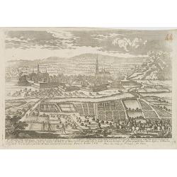
Fribourg Ville d'Allemagne Capitale du païs de Brisgaw.
A very RARE panoramic of the city of Fribourg. The plate is numbered in red pencil in the upper right corner.Engraved by Pierre Aveline (Paris, c.1656 - 23 May 1722). He ...
- $250 / ≈ €234
Place & Date: Paris, 1690-1720
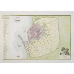
Pianta della citta di Livorno.
Very finely engraved and detailed plan of Livorno. Engraved by V.Angeli and included in: Atlante Geografico dell Italia . To the left, a key to the principal buildings a...
- $150 / ≈ €140
Place & Date: Rome, 1860
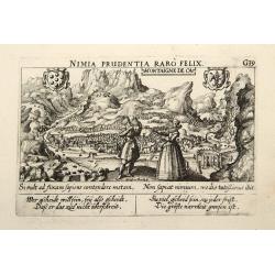
Montaigne de Ca.
In the foreground, a couple of which the man is holding a quadrant with a verse in two languages underneath the picture.The poet and topographer from Comothau, Daniel Mei...
- $85 / ≈ €80
Place & Date: Frankfurt, 1623-1678
A chart of the coast of Africa from Cape Virde to Cape Bona Esperansa.
Rare and attractive chart of the western part of Africa.
- $800 / ≈ €749
Place & Date: London, 1748
![Teatro Belgico. [Title page ]](/uploads/cache/13992-250x250.jpg)
Teatro Belgico. [Title page ]
Rare tile page from Teatro Belgico, showing an allegory surrounded by court members: on the lower part, seven coats of arm from the Dutch northern provinces.
- $200 / ≈ €187
Place & Date: Amsterdam, 1690

Carte générale de la mer des Indes dressée par P. Daussy et P.E. Wissocq, grave par Chassant, ecrit par J.M. Hacq.
Magnificent and detailed large-scale chartdepicting the Indian ocean, with east coast of Africa, Madagascar, Arabian Peninsula, India, China, etc .Including the West coa...
- $1000 / ≈ €936
Place & Date: Paris, 1837-1869

Pas-kaart vande Zee kusten van Venecuela met de Byleggende Eylanden. . .
Rare chart of the coast of Venezuela, including the islands of Curaçao, Bonaire, Aruba, etc.The chart has two insets, one (15x22cm) with a map of Curaçao, one smaller w...
Place & Date: Amsterdam, 1680
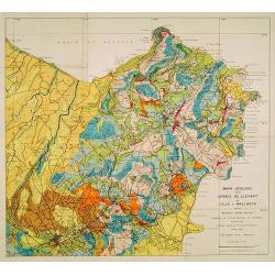
Mapa geologic de les serres de Llevant de l'illa de Mallorca.
Geological map showing part of the island Mallorca Manacor, Son Severa, Capdepera.. After a design by D.Ferrá. Dibuxá, in lower right corner: D.Ferrà. Dibuxá.Provenan...
- $150 / ≈ €140
Place & Date: Palma, 1932
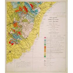
Mapa geologic de les serres de Llevant de l'illa de Mallorca.
Geological map showing part of the island Mallorca Felanitx, Santanyi, Porto Cristo, Porto Colom.., including a legend with geological and topographical signs. After a de...
- $100 / ≈ €94
Place & Date: Palma, 1932

Carte géologique détaillée. Beyrouth.
Geological or soil map showing part of Lebanon with Beyrouth, including in top a colored legend with signs of the different geological ages. Provenance : Fondation P. Fal...
Place & Date: Liban, Service geographique des F.F.L., 1945.

Carte géologique détaillée. Jezzîne.
Geological or soil map showing part of Lebanon with Jezzîne, including a legend with signs of the different geological ages and giving many information of greatest inter...
Place & Date: Liban, Service geographique des F.F.L., 1945.

Carte géologique détaillée. Râchaïya Nord.
Geological or soil map showing part of Lebanon with Râchaïya , including a legend with signs of the different geological ages and giving many informations of greatest i...
Place & Date: Liban, Service geographique des F.F.L., 1945.

Carte géologique détaillée. Zahle.
Geological map showing part of Lebanon with Zahle. , including a legend with signs of the different geological ages. Provenance : Fondation P. Fallot
Place & Date: Liban, Service geographique des F.F.L., 1945.

Carte geologique detaillee. Jbail.
Geological or soil map showing part of Lebanon with Jbail antique Byblos Ancien Port phenicien / scale 1 : 50 000., including a legend with signs of the different geologi...
Place & Date: Liban, Service geographique des F.F.L., 1945.
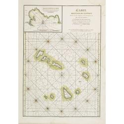
Carte des Iles du Cap-Verd Dressée sur les remarques et les observations les plus exactes des Navigateurs.
French sea chart of the Cap Verde Islands, situated 570 kilometers off the coast of Western Africa.Latitude and longitude scales, compass rose and system of rhumb lines, ...
- $100 / ≈ €94
Place & Date: Paris, Brest, chez Demonville, 1775

Carte réduite de l'Océan Oriental, depuis Le Cap de Bonne Espérance jusqu'à l'Isle Formose.
French chart covering the seas between the Cape of Good Hope until Taiwan and the West Coast of Australia. Prepared by Jacques-François L'Abbé Dicquemare (1733-1789). L...
- $1000 / ≈ €936
Place & Date: Paris, Brest, chez Demonville, 1775
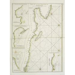
Carte Orientale de Madacascar Depuis la Rivière Ivondrou jusqu'à Mananzari.
Large sea sea chart of the southeast coastline of Madagascar and four inset maps of the harbors and anchorage of Tamatave, Foulpointe, Teintingue und Veninguebe. Inset ma...
- $125 / ≈ €117
Place & Date: Paris, Brest, chez Demonville, 1775
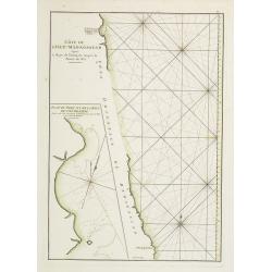
Côte de l'Isle de Madagascar depuis la Baye de Vohemare jusqu'à la pointe de l'Est. Plan du Port et de la Baye du Cap de l'Est.
French chart of the east coast of Madagascar.Latitude and longitude scales, compass rose and system of rhumb lines, soundings near coast and in bay areas.D' Après de Man...
- $100 / ≈ €94
Place & Date: Paris, Brest, chez Demonville, 1775
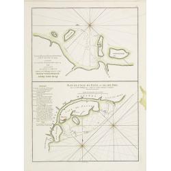
Plan des Isles Querimbo, Oybo, et Matemo / Plan de l'Ile de Patte et de son Port.
French sea chart of Isles Patte, Querimbo, Oybo, Matemo on East coast of Madagascar. Latitude and longitude scales, compass rose and system of rhumb lines, soundings near...
- $75 / ≈ €70
Place & Date: Paris, Brest, chez Demonville, 1775
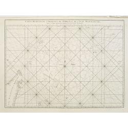
Carte réduite de l'Archipel du Nord-Est de l'Ile Madagascar.
French sea chart of an archipelago off the coast of Madagascar. The northeastern coast of Madagascar is included.Latitude and longitude scales, compass rose and system of...
- $100 / ≈ €94
Place & Date: Paris, Brest, chez Demonville, 1775
Carte de l'Entrée du Golf de la Mer Rouge. / Plan de La Rade de Moka.
French sea chart of the entry of the Red Sea showing both the African and Arabian coasts. With two inset charts: Plan de La Rade de Moka. and one with the coasts south of...
- $450 / ≈ €421
Place & Date: Paris, ca 1775
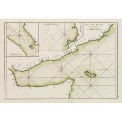
Vues des Cap d'Aden, de St. Antoine, et de Bab-El-Mandeb, sur la Côte Méridionale de l'Arabie Heureuse. Vues de l'Isle de Socotra
Coast profiles near Cape Aden in Yemen and in the lower part coastal profiles near Socotra, an island east of the Horn of Africa and 380 kilometers (240 mi) south of the ...
- $250 / ≈ €234
Place & Date: Paris, Brest, chez Demonville, 1775
Carte Plate qui comprend La partie septentrionale de LA Cöte de Coromandel et les Côtes de Golconde , D' Orcha et de Bengale.
French chart of Coromandel in India. West to the top.Latitude and longitude scales, compass rose and system of rhumb lines, soundings near coast and in bay areas.D' Aprè...
- $150 / ≈ €140
Place & Date: Paris, Brest, chez Demonville, 1775
Carte de la Côte Orientale du Golfe du Bengale.
French sea chart of coast northeast of India. Latitude and longitude scales, compass rose and system of rhumb lines, soundings near coast and in bay areas.D' Après de Ma...
- $150 / ≈ €140
Place & Date: Paris, ca 1775

A chart of the China Sea inscribed to Monsr. D'APRES de MANNEVILLETTE .. To A.Dalrymple.
Most important milestone chart is based upon the surveys made from navigational surveys by Alexander Dalrymple (1737-1808]. He was the first hydrographer of the British A...
Place & Date: Paris, ca 1775
![[Title page] Atlas François contenant les Cartes Géographiques dans lesquelles sont très exactement remarquez les Empires, Monarchies, Royaumes et Estats de l'Europe, de l'Asie; de l'Afrique et de l'Amérique.](/uploads/cache/17240-250x250.jpg)
[Title page] Atlas François contenant les Cartes Géographiques dans lesquelles sont très exactement remarquez les Empires, Monarchies, Royaumes et Estats de l'Europe, de l'Asie; de l'Afrique et de l'Amérique.
Decorative title page with a certain holding the title : Atlas François contenant les cartes géographiques . . . les Empires, Monarchies, Royaumes et Estats de l'Europe...
- $250 / ≈ €234
Place & Date: Paris, 1695
![[Title page] Le nouveau et curieux Atlas Géographique et historique ou Le Divertissement des Empereurs, Roys, et Princes. Tant dans laz Guerre que dans la Paix.](/uploads/cache/17244-250x250.jpg)
[Title page] Le nouveau et curieux Atlas Géographique et historique ou Le Divertissement des Empereurs, Roys, et Princes. Tant dans laz Guerre que dans la Paix.
Decorative title page. According to its title, this atlas was intended for the entertainment of emperors, kings, and princes!
Place & Date: Paris, 1719
![[Title page] La France Nouvel Atlas illustré des Départements & des Colonies . . .](/uploads/cache/17248-250x250.jpg)
[Title page] La France Nouvel Atlas illustré des Départements & des Colonies . . .
Title page from a French atlas, the decoration executed in Neo-Gothic style. In bottom part a globe and a map of France, to the left an Atlas-figure.Engraved by Villerey.
- $30 / ≈ €28
Place & Date: Paris, 1880

(Title page) Recueil Contenant des Cartes Nouvelles Dressées Sur des Morceaux.
Rare title page. Le Rouge was a military Ingenieur for fortifications. He was a map-maker for the army and Marine Royale. He was active between 1740 and 1780, in Paris at...
- $100 / ≈ €94
Place & Date: Paris, 1742
![[Title page] Isolario.](/uploads/cache/17785-250x250.jpg)
[Title page] Isolario.
Fine title page from Isolario Dell''''Atlante Vento..More about Coronelli. [+]
Place & Date: Venice, 1691
![[Titlepage] Galliae tabulae geographicae..](/uploads/cache/21219-250x250.jpg)
[Titlepage] Galliae tabulae geographicae..
Decorative title page from the atlas by Mercator, surrounded with strapwork designs, garlands, fruit, birds and a portrait of a king.Read more about title pages. [+]
- $220 / ≈ €206
Place & Date: Amsterdam, 1613
![[Titlepage] Italiae, Sclavoniae, et Graeciae tabula geographice..](/uploads/cache/21220-250x250.jpg)
[Titlepage] Italiae, Sclavoniae, et Graeciae tabula geographice..
The text in this decorative title page from the atlas by Mercator is enclosed in an architectural framework engraved with cherubs, garlands and an eagle.Read more about t...
- $220 / ≈ €206
Place & Date: Amsterdam, 1613
![{Title page] Introduction a la geographie, Contenant.. (2 sheets)](/uploads/cache/21495-250x250.jpg)
{Title page] Introduction a la geographie, Contenant.. (2 sheets)
In lower part title page an interesting world map in double hemisphere. The map is printed north up and is mirror imaged. Showing California as an island. French text on ...
Place & Date: Amsterdam, c. 1745

Grand Theatre de la Guerre sur les Frontieres de France & D'Allemagne..
Elegant arrangement of ten vignette views representing fortresses on or near the Rhine, including one view of a French Siège de Philipsbourg. The forts on the Rhine cons...
Place & Date: Amsterdam, c. 1745
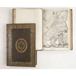
De Bello Belgico, Decas PrimaDeces II.
Each volume contains an engraved title with a representation of the Netherlands and Belgium in the shape of a lion, with one paw resting on a shield bearing the title, a ...
Place & Date: Rome, Franciscus Corbelletus, 1632-1647
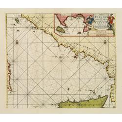
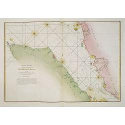
Paskaart der Zeekusten van Italien Tusschen Piombino en C. dell Arme Met de Noord-kust van 't Eylandt Sicilia..
Centered off the Ponziane Islands, this sea chart covers the area of the Tyrrhenian Sea, delimited by Sardinia, the Elba island, the Strait of Messina and Trapani. It con...
- $1500 / ≈ €1404
Place & Date: Amsterdam, 1708