Search Listings matching "ukraine"
![[Schwarzes Meer] Nr 1](/uploads/cache/37946-250x250.jpg)
[Schwarzes Meer] Nr 1
Uncommon map of the Black Sea and Crimea. In lower part a scale. Prepared by Friedrich Handtke (1815-1879). Map set in a decorative border.
- $120 / ≈ €104
Date: Glogau, Leipzig, 1877
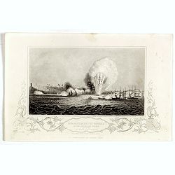
Bombardment of Odessa by the English and French April 22 1854, explosion on the imperial mole . . .
Scene from the Crimea war, showing a bombardment of Odessa, 22nd April 1854 (during Crimean War, 1853-56), by English and French forces, explosion imperial mole (breakwat...
- $30 / ≈ €26
Date: London, ca. 1879

Mapa Polski i Krajów Osciennych - Wydanie trzecie. Opracowal Stanislaw Max. Wydani M. Arcta.
‘The Birth of Modern Poland on a map’ - an excellent wall map of Poland and surrounding regions, published in Warsaw near the end of World War I, when Poland’s fate...
Date: Warsaw, [H. Sklodowski], 1918
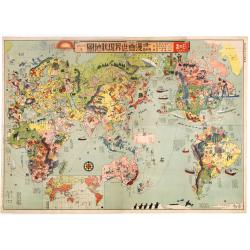
Japanese Stereotype Map of the World from 1932 Share Hitome de wakaru Manga sekai genjō chizu. At a glance: Cartoon Map of the Current World Situation. 目でわかる 漫画世界現状地圖
An extraordinary satirical map of the world was seen through Japanese eyes in the early 1930s as Japanese imperial ambitions strengthened. The map was published as an edi...
Date: Tokyo, Showa 7, or 1932

Karte der Ukraina.
A large political, economical and transportation map of Ukraine, printed three months after the beginning of the WW II in Ukraine. Shows the newest borders, streets and r...
Date: Vienna: Freytag u. Bernd u. Artaria August 1941
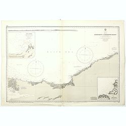
Black sea - Sheet IX - Bosporus to Kerempe Burnu . . .
A highly corrected version of Admiralty chart 2238 originally published 16th June 1854. Edition Date 1980.Detailed chart of Bosporus. With prohibited landing places in pu...
- $100 / ≈ €86
Date: London, 1854-1980