Search Listings matching "ukraine"
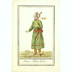
Homme Tartare d'Usbec.
Originally hand-colored costume mezzotint of a man from Uzbekistan engraved by Félix Mixelle and Lachaussée Jeune after Jacques Grasset de Saint-Sauveur.As an etcher, d...
Place & Date: Paris,1801-1806
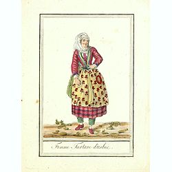
Femme Tartare d'Usbec.
Originally hand-colored costume mezzotint of a woman from Uzbekistan engraved by Félix Mixelle and Lachaussée Jeune after Jacques Grasset de Saint-Sauveur.As an etcher,...
Place & Date: Paris,1801-1806
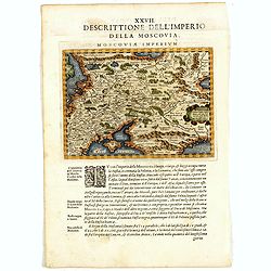
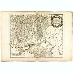
Descrittione Dell'Imperio della MOSCOVIA IMPERIUM.
Uncommon map including Latvia, Livonia, Lithuania, the Ukraine, and northern Part of the Black Sea and the Caspian Sea, Siberia, Georgia, Azerbaijan, Kazakhstan.Giovanni ...
Place & Date: Venice, 1596
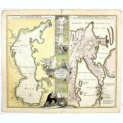
Geographica Nova ex Oriente gratiosissima, duabus tabulis specialissimis contenta, quarum una Mare Caspium..
Map of the Caspian Sea and the peninsula of Kamchatka (Jedso) in northeast Asia on one sheet.Separated by an attractive panel with figurative title cartouche, cherubs, an...
Place & Date: Nuremberg, 1730
Partie méridionale de la Russie Européenne. . .
Detailed map of Ukraine and the Crimea. In lower right corner inset map of Cosaques. From his "Atlas Universel".Gilles Robert de Vaugondy (1688–1766), also kn...
Place & Date: Paris, 1752
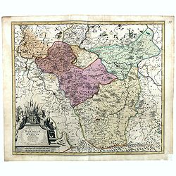
Regni Poloniae, ducatus Mazoviae et province Cujaviae / descriptio emendata per R. & I. Ottens
Very rare map of Poland Lithuania and Ukraine, etc. Engraved by A. Schut.Joachim Ottens (1663 - 1719) and his sons Renier and Joshua were prominent Dutch booksellers and ...
Place & Date: Amsterdam, 1725
Selling price: $1500
Sold in 2017
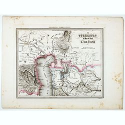
Il Turkestan il Mar d'Aral ed il Mar Caspio.
Uncommon map of Turkestan with the Northern part of the Caspian Sea, prepared by Francesco Costantino Marmocchi. Above the map "Geografia Commerciale". From &qu...
Place & Date: Genova, Paolo Rivara fu Giacomo, 1858
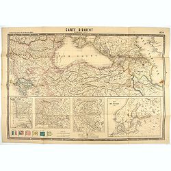
Carte d'Orient par Kraminski ingénieur.
Large map of Orient, with an insert of four maps (Constantinople plan - Map of Europe - Map of Russia - Plan of Baltic sea). With flags in the lower left part. color key ...
Place & Date: Paris, 1854

Black Sea.
Decorative steel engraved map of the Black Sea with inset views of Sebastopol and Odessa. There are also vignettes of Constantinople, Sinope and Varna. Taken from "T...
- $90 / ≈ €84
Place & Date: London, London Printing and publishing Company of London, ca. 1851

A unique composite atlas with updated Porro maps.
Unique composite atlas containing in total 84 maps - 82 maps engraved by Girolamo Porro and heavenly reworked around 1686 and 2 newly engraved maps; Piccola Tartaria (Cr...
Place & Date: Venice, 1686

Poloniae, Lituaniaeq descriptio.
Fine general map of Poland. Rare; the second plate appearing in the post-1595 edition of the Theatrum. Only used until 1612.Based on the now-lost map of Waclaw Grodecki. ...
Place & Date: Antwerp, 1612
![[Crimea]. Carte de la Cromée.](/uploads/cache/25719-250x250.jpg)
[Crimea]. Carte de la Cromée.
Mapmaker, Captain Jan Hendrik van Kinsbergen (1735-1819). Published by H. Friesman in 1787. This map first appeared in 1776 and was the first Russian map of the newly ann...
Place & Date: Amsterdam, H. Frieseman, 1787

Nova Maris Caspii et Regions Usbeck..
A detailed map of part of Russia, Central Asia centered on the Caspian, Uzbek territory to the east of the Caspian and northern Persia. A finely engraved, uncolored title...
Place & Date: Nuremberg, 1735

Carte Marine De La Mer Caspiene levée suivant les ordres de S.M.Cz. En 1719, 1720 et 1721.
Detailed of the Caspian Sea, prepared by Karl van Verden in 1722. Van Verden was a Russian sailor and the Czar's Special Commander, who produced the first accurate map of...
Place & Date: Paris, ca. 1725

L'escadre alliée bombarde les forts extérieurs de Sébastopol. (18 octobre 1854)
Beautiful Crimean War lithography by Becquet after a painting by Louis Le Breton. The print illustrates the ships "Fort Constantin", "la ville de Paris&quo...
Place & Date: Paris, 1860

LA RUSSIE NOIRE ou POLONOISE qui Comprend les PROVINCES DE LA RUSSIE NOIRE de VOLHYNIE et de PODOLIE divisées en leurs Palatinats Vulgairement Connües sous le Nom D'VKRAINE ou PAYS DES COSAQUES.
Very rare map of the Ukraine and Poland, prepared by Sanson in 1675 in a third state, published by the heirs of Sanson, in Paris in 1706. The imprint changed to: Par les ...
Place & Date: Paris, 1706
![[MANUSCRIPT] Carte nouvelle de la Crimée et des pays circonvoisins.](/uploads/cache/30484-250x250.jpg)
[MANUSCRIPT] Carte nouvelle de la Crimée et des pays circonvoisins.
A beautiful manuscript map on paper. Showing the northern part of the Black Sea region with Crimea.Interesting are the border lines of "New Serbia", shown in th...
Place & Date: ca. 1752-1764

Military map of the countries between Odessa & Perekop with the stations of the Russian forces.
Rare colored linen-backed map showing Russian troop positions and Odessa Batteries. On the inside of the cover a list of "Wyld's list of recent publications : seat o...
Place & Date: London, ca. 1855

The town & harbour of Sevastopol with the batteries & approaches. . .
Rare colored linen backed map showing the harbour and town of Sevastopol, with soundings. In upper left corner a inset map (65x150mm) of the Black Sea. In bottom part a l...
Place & Date: London, March 27th, 1854

La Pologne Dressée sur ce qu'en ot donné Starovolsk, Beauplan, Hartnoch. . .
Large map of Poland, Lithuania, Belarus and part of Ukraine. The map is filled with detail and decorated with a title cartouche flanked by mythological figures.According ...
Place & Date: Paris, 1773 - 1780
![[Europe, Eastern, Sarmatia, Ukraine]](/uploads/cache/33854-250x250.jpg)
[Europe, Eastern, Sarmatia, Ukraine]
Wood block printed map and one of earliest printed representation of Europe, Eastern, Sarmatia, Ukraine prepared L. Fries after Martin Waldseemüller.Based on the slightl...
Place & Date: Vienna, Trechsel, G., 1525 -1541
![.[Georgia (Republic), Sarmatia, Ukraine]](/uploads/cache/33870-250x250.jpg)
.[Georgia (Republic), Sarmatia, Ukraine]
Wood block printed map and one of earliest printed representation of Georgia (Republic), Sarmatia, Ukraine prepared by Martin Waldseemüller. Based on the slightly larger...
Place & Date: Vienna, Trechsel, G., 1525 -1541

A Map of the Environs of Constantinople Drawn from a great number of accurate astronomical & geographical manuscripts and printed documents, by A. Arrowsmith 1801 and 1804.
Arrowsmith’s large and detailed map of the Ottoman Empire and the Black Sea, with Cyprus, Crete and the Greek Islands in the Mediterranean Sea, Albania, Bosnia and Herz...
Place & Date: London, No.10 Soho Square, 4th September 1804

The Crimea, chiefly from surveys made by order of the Russian government. . .
Map of Crimea and the Sea of Azov. In lower right corner two inset maps showing Sebastopol inlet and harbour and a second one with the Black Sea. This second maps shows t...
Place & Date: London, 1854