Search Listings matching "curated-collection"

Nova Orbis Tabula in Lucem edita A.F.de Wit.
According to Shirley, De Wit's map is one of the most attractive of its time. The brilliant scenes in the corners combine images of the four seasons, the elements, and th...
Place & Date: Amsterdam, 1680

Mare Balticum. . . / Nieuwe Pascaert van de Oost Zee. . .
Decorative chart showing the Baltic sea, with a splendid cartouche of royal figures. A re-issue of the De Wit copper plates, now with many improvements.
- $2500 / ≈ €2339
Place & Date: Amsterdam ca.1680

Pascaerte van Carybes, Nieu Neder landt, Brazil. . .
This progenitor chart covers the American shores of the Atlantic Ocean. This chart by Theunis Jacobsz. was most probably engraved close to his death in 1650 or shortly af...
- $2200 / ≈ €2059
Place & Date: Amsterdam, 1653-1681

Magnae Prussiae Ducatus Tabula denuo correcta et in lucem edita per Nicolaum Visscher.
Striking old color example of Visscher's map of Prussia and part of the Baltic region. Includes a gorgeous cartouche and banner key held aloft by 2 cherubs, plus 4 sailin...
- $1500 / ≈ €1404
Place & Date: Amsterdam, 1690
![[Il mondo a pezzi - Europa].](/uploads/cache/42849-250x250.jpg)
[Il mondo a pezzi - Europa].
Satirical representation of the division of the world by the main European powers. At the center of the scene a globe on which is written "MONDO Maledeto Interesse ...
Place & Date: Bologna, 1690
![Praghe. [ Prague ]](/uploads/cache/27801-250x250.jpg)
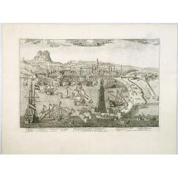
Praghe. [ Prague ]
A rare panoramic of Prague with over the whole length of the lower part 3 columns of poems in Dutch, French, German and English.Frederick de Wit published after 1694 a t...
- $1500 / ≈ €1404
Place & Date: Amsterdam, 1694

Belgii novi, angliae novae, et partis Virginiae . . .
This example is state 3 of the original Janssonius plate, printed after Schenk acquired the plates at public auction in 1694 from the heirs of Jansson van Waesberge. The ...
Place & Date: Amsterdam, 1694

Ducatus Prussiae tam Polono Regiae. . .
This is a rare issue of Frederick de Wit's attractive map of the northern part of Poland, Prussia and the Baltic regions.Very decorative title cartouche, including three ...
Place & Date: Amsterdam, 1698

Nieuwe gelyk Graadige Paskaart van de Kust van Guiana in West-Indien.
Detailed chart of Guiana in South America. Two scales are given in both maps: Dutch, French and English nautical miles.The inset chart provide detailed view of the Camopi...
- $650 / ≈ €608
Place & Date: Amsterdam, 1684 - 1704

Nieuwe en Nette Afteekening van het Eyland Corsica en het Eyland Elba vertoonende alle desselfs Havenen, Steeden en Rivieren . . .
Highly decorative large sea chart of Corsica, Sardinia and Elba, including multiple sailing ships, compass roses, cartouche, coat of arms, rhumb lines, topographical deta...
Place & Date: Amsterdam, ca. 1710
![[12 volumes] Recueil des voyages qui ont servi à l'établissement et aux progrez de la Compagnie des Indes Orientales, forméedans les Provinces-Unies des Païs-Bas...](/uploads/cache/43700-250x250.jpg)
[12 volumes] Recueil des voyages qui ont servi à l'établissement et aux progrez de la Compagnie des Indes Orientales, forméedans les Provinces-Unies des Païs-Bas...
An important richly illustrated compendium of the first Dutch voyages to East India, of great interest for the history and establisment of the Dutch global trade, particu...
- $5000 / ≈ €4679
Place & Date: Rouen, Pierre Le Boucher, 1725
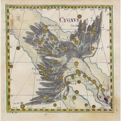
Cygnus.
Uncommon celestial print of Cygnus, published by Corbinianus Thomas in the Manuductio ad Astronomiam, Juxta modum Bayeri, Mathematici celeberrimi, concinnata, multis,…e...
- $350 / ≈ €328
Place & Date: Frankfurt & Leipzig, c.1730

Vorstellung der Evangelisch-Ostindischen Kirche Augsburger Protestanten.
Very decorative and rare print to commemorate the 200 year Confession of the Augsburg Protestant Confession. Engraved by J. Kleinschmidt after a design of E. Ridinger.Dis...
- $1500 / ≈ €1404
Place & Date: Augsburg, 1732
![[World and 4 continents] Carte Geographique Astronomique Chronologique et Historique du Monde.](/uploads/cache/63024-250x250.jpg)
[World and 4 continents] Carte Geographique Astronomique Chronologique et Historique du Monde.
French wall map of the world in 4 sheets published by Crépy "à l'entrée du Cloistre de St. Benoist du côté des maturins". A decorative wall map of the worl...
Place & Date: Paris, 1720-1735

A Map of the British Empire in AMERICA with the French, Spanish and Hollandish Settlements Adjacent Thereto. by Henry Popple. / Nouvelle Carte Particuliere de L'Amerique . . .
The four sheet Dutch edition of Popple's monumental map of North America, in mint condition. Encompassing the West Indies, Florida, Louisiana, Texas and Central America.T...
Place & Date: Amsterdam, ca. 1737
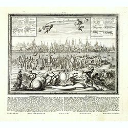
Constantinopolis Constantinopel.
Very rare and decorative panoramic view of Istanbul prepared by Friedrich Berhard Werner and published by Martin Engelbrecht. The engraving is done by Johann Georg Ringli...
- $3500 / ≈ €3275
Place & Date: Augsburg, M.Engelbrecht, ca.1730-1740

Les Provinces confederées du Pais-Bas
The first wall map of the Seven Provinces of 1651, re-issued as 'Stoel des Oorlogs' by Covens & Mortier. The first issue of the present wall-map is known to be includ...
Place & Date: Amsterdam, c. 1740
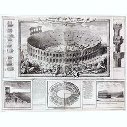
Anfiteatro detto l'Arena di Verona.
Large two sheet copper engraving of the Amphitheater of Verona after a design of Adriano Cristofali. On three sides it is surrounded by architectural details interspersed...
- $2200 / ≈ €2059
Place & Date: Verona, 1744
![ATLAS RUSSICUS mappa una generali et undeviginti specialibus vastissimum Imperium Russicum cum adiacentibus regionibus [repeated in French].](/uploads/cache/27877-250x250.jpg)
ATLAS RUSSICUS mappa una generali et undeviginti specialibus vastissimum Imperium Russicum cum adiacentibus regionibus [repeated in French].
After an unnumbered general map of Russia there are 13 numbered maps that cover European Russia (scale 1, 1.527.000). The other (last) 6 maps cover Asian Russia (Siberia,...
Place & Date: St Peterburg, Akademie von Wissenschaften. 1745

Le Théâtre du monde dédié au roi contenant les cartes générales et particulières des royaumes et états qui le composent.
The present example of the Théâtre du monde is the reissue of 1746 by Jean-Baptiste Nolin II. This scarce atlas is illustrated with 123 maps mostly double-page, in orig...
Place & Date: Paris, 1746

Manuscript map of the Bay of Nagasaki.
An extremely rare manuscript chart in brown ink and wash color on a printed sheet of paper with a system of rhumblines and latitude scales. This chart shows the Bay of Na...
Place & Date: Amsterdam, 1750
Seville. Ville Archiepiscopale et Capitale du Raume d'Andalousie en Espagne. . .
A very decorative and extremely rare view of Seville, including a numbered (1-37) key in the lower part. Published by Jacques Chéreau, (1688 - 1776). Engraved by Aveline...
- $2000 / ≈ €1871
Place & Date: Paris, ca.1750
Barcelone, Ville Capitale de la principauté Catalogne. . .
A very decorative and scarce view of Barcelona, including a numbered key ( 1-29 ) in the lower part. Published by Jacques Chéreau, (1688 - 1776). Engraved by Aveline and...
- $2000 / ≈ €1871
Place & Date: Paris, ca.1750
Madrid Villa Capital Del Reyno D'Espana.. / Madrid ville capitale du Royaume d'Espagne . . .
A very decorative and scarce town view of Madrid, including a numbered key ( 1-17 ) in Spanish and French in the lower part. Published by Jacques Chéreau, (1688 - 1776)....
- $3000 / ≈ €2807
Place & Date: Paris, ca.1750

Nieuwe en zeer accuraate Zee-Caart van de Hollandse Wal strekkende van de Maas tot Texel opgenomen door Jan Rokusz Douw, , ,
A very fine and rare chart of the coast of Holland, Prepared by Jan Rokusz, Douw and Agge Roskam Kool.Embellished with a very decorative cartouche with a dedicational tex...
Place & Date: Amsterdam, 1750
![[Complete set of maps of Japan] Imperium Japonicum Per Regiones Digestum Sex et Sexaginta Atque Ipsorum Japonensium Mappis Descriptum Ab Hadriano Relando.](/uploads/cache/41590-250x250.jpg)
[Complete set of maps of Japan] Imperium Japonicum Per Regiones Digestum Sex et Sexaginta Atque Ipsorum Japonensium Mappis Descriptum Ab Hadriano Relando.
Complete set of 11 maps Reland's map of Japan, the first map to use Sino-Japanese characters on a European printed map and represents a radical departure from prior Europ...
Place & Date: Amsterdam, 1751
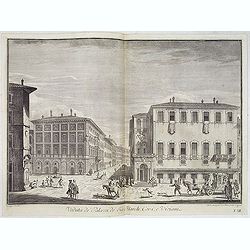
Veduta de' Palazzi de' Sig. March. Corsi e Viviani.
Lively street scene with several palaces in Florence after Giuseppe Zocchi (1711or 1717 - 1767) and engraved by Mich. Mariesschi and Vincenzo Francesschini. From "Sc...
- $450 / ≈ €421
Place & Date: Florence, Bouchard, 1754

Carolinae Floridae nec non Insularum Bahamensium cum partibus adjacentibus delinatio ad Exemplar Londinense in lucem edita . . . Ao. 1755.
The German edition of this map of Carolina, Florida, and the Bahama Islands in full original colors. Published in Seligmann's "Sammlung verschiedener auslaendischer ...
Place & Date: Nuremberg, 1755

Karte von den Kusten von Arabien . . .
Manuscript map of Arabia. A close copy of Bellin's map of the Arabian Peninsula. In the lower right margin "Tom A, vol V."A title cartouche in the lower left co...
Place & Date: Germany, ca. 1760
![[MANUSCRIPT] Carte nouvelle de la Crimée et des pays circonvoisins.](/uploads/cache/30484-250x250.jpg)
[MANUSCRIPT] Carte nouvelle de la Crimée et des pays circonvoisins.
A beautiful manuscript map on paper. Showing the northern part of the Black Sea region with Crimea.Interesting are the border lines of "New Serbia", shown in th...
Place & Date: ca. 1752-1764
Neue und vollständige Topographie der Eidgnossschaft, in welcher die in den dreyzehen und zugewandten auch verbündeten Orten und Landen dermal befindliche Städte, Bischthümer, Stifte, Klöster, Schlösser, Amts-Häuser, Edelsitze und Burgställe...
The first edition of Herrliberger's work on the topography of Switzerland. - The rarest book on Switzerland rarely found complete.Illustrated with an engraved allegorical...
- $5500 / ≈ €5146
Place & Date: Zurich, Johann Kaspar Ziegler, 1754-1773

Plan de St. Jean de Luz avec les différents projets d'agrandissem.t du port.
Very rare and beautiful plan of the city and bay of Saint-Jean-de-Luz, detailing the projects of expansion of the port undertaken in 1780.The plan indicates the Artha Roc...
- $2000 / ≈ €1871
Place & Date: Paris, 1784

Carte de la Petite Tartarie Dresee par ordre de l'Imperatries de toutes las Russies.
The very rare first edition of De Leth's map of the southern part of Ukraine, with detailed annotations regarding the Cossacks and an explanatory key. Based on a Russian ...
- $1750 / ≈ €1638
Place & Date: Amsterdam, ca. 1785
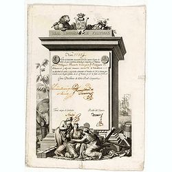
A scarce Real Compañia de Filipinas 250 Pesos deed issued in 1785
A scarce Real Compañia de Filipinas 250 Pesos deed issued in 1785. Share nº 27324, hand signed by several company officials.Engraved by Fernando Selma (1752-1810) after...
- $1750 / ≈ €1638
Place & Date: Spain, 1785
![[Crimea]. Carte de la Cromée.](/uploads/cache/25719-250x250.jpg)
[Crimea]. Carte de la Cromée.
Mapmaker, Captain Jan Hendrik van Kinsbergen (1735-1819). Published by H. Friesman in 1787. This map first appeared in 1776 and was the first Russian map of the newly ann...
Place & Date: Amsterdam, H. Frieseman, 1787
![CH'ONHA CHIDO [Atlas of all under Heaven]](/uploads/cache/33625-250x250.jpg)
CH'ONHA CHIDO [Atlas of all under Heaven]
The Ch’onha chido [Atlas of all under Heaven] is a late 18th century copy of the traditional Korean atlas produced in the early Choson dynasty (1392-1910). One of the m...
Place & Date: Korea, ca. 1790
![[ LANDSKROON ]. Oranda Fune no zu [= Depiction of a Dutch Ship].](/uploads/cache/28003-250x250.jpg)
[ LANDSKROON ]. Oranda Fune no zu [= Depiction of a Dutch Ship].
A very large and extremely detailed Japanese drawing on rice paper of a Dutch ship at the artificial island Deshima, the VOC's outpost in Nagasaki harbour. In the drawing...
Place & Date: Japan, Kansei 4, 2nd month, 9th day, 30 March? 1792

Mapa De la parte de la Isla Formosa sa perteneciente al Emperadotde la China sacado por Ord. De S.M.
Extremely rare map of the west coast of Taiwan, the Punghu or Pescadore Islands, and the Fokien or Fujian coast of China. Several ancient Taiwanese cities are noted, incl...
Place & Date: Manilla, Seminario Conciliar, y Real de San Carlos, 1788-1792
![[Set of five maps] Carte Générale de la Terre ou Mappe Monde](/uploads/cache/41145X-250x250.jpg)
[Set of five maps] Carte Générale de la Terre ou Mappe Monde
Rare and decorative set of five wall maps of the world and the four continents, prepared by Clouet, in very fine bright contemporary coloring. Each map ca. 965 x 1230 mm ...
Place & Date: Paris and Cadiz, Mondhare, 1785-1793

A plat of the East Sea. By William Fisher and Richard Mount...
An important sea chart of the East Sea with coast lines of Poland, Russia, Sweden, published by William Fisher and Richard Mount in London.Richard Mount (1654-1722) was a...
- $1800 / ≈ €1684
Place & Date: London, 1795