Search Listings matching "curated-collection"

Noordoost Cust van Asia van Japan tot Nova Zembla.
Important for its early depiction of Hokkaido and the Islands to the North of Japan. Ships navigate the seas around the Siberian, Chinese and Japanese coast extending as ...
- $3000 / ≈ €2807
Place & Date: Amsterdam, 1666

Coloniensis Archiepisscopatus.
Extremely rare first edition of this beautiful map of Cologne and Dusseldorff.Jodocus Hondius Jr. planned to produce a new modern atlas less dependent on the Mercator pla...
Place & Date: Amsterdam, 1629

Manuscript map of the Bay of Nagasaki.
An extremely rare manuscript chart in brown ink and wash color on a printed sheet of paper with a system of rhumblines and latitude scales. This chart shows the Bay of Na...
Place & Date: Amsterdam, 1750

Les Provinces confederées du Pais-Bas
The first wall map of the Seven Provinces of 1651, re-issued as 'Stoel des Oorlogs' by Covens & Mortier. The first issue of the present wall-map is known to be includ...
Place & Date: Amsterdam, c. 1740

Pascaerte van Carybes, Nieu Neder landt, Brazil. . .
This progenitor chart covers the American shores of the Atlantic Ocean. This chart by Theunis Jacobsz. was most probably engraved close to his death in 1650 or shortly af...
- $2200 / ≈ €2059
Place & Date: Amsterdam, 1653-1681

Nova Orbis Tabula in Lucem edita A.F.de Wit.
According to Shirley, De Wit's map is one of the most attractive of its time. The brilliant scenes in the corners combine images of the four seasons, the elements, and th...
Place & Date: Amsterdam, 1680
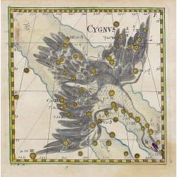
Cygnus.
Uncommon celestial print of Cygnus, published by Corbinianus Thomas in the Manuductio ad Astronomiam, Juxta modum Bayeri, Mathematici celeberrimi, concinnata, multis,…e...
- $350 / ≈ €328
Place & Date: Frankfurt & Leipzig, c.1730

Pas-kaart vande Zee kusten van Venecuela met de Byleggende Eylanden. . .
Rare chart of the coast of Venezuela, including the islands of Curaçao, Bonaire, Aruba, etc.The chart has two insets, one (15x22cm) with a map of Curaçao, one smaller w...
Place & Date: Amsterdam, 1680

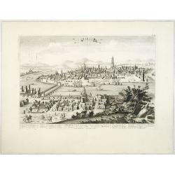
Desciption de lopulente et manifique ville de Venise.
Extremely rare panoramic view of Venice and neighboring islands (Murano, Burano, Torcello and Mazorbo), clearly depicting the city's architectural landmark. The surroundi...
Place & Date: Paris, 1646

.Pascaerte Van't Westelyckste der Middelandsche Zee. . .
An eye-catching chart of the western part of the Mediterranean Sea.Pieter Goos (ca. 1616-1675) was one of the most important cartographer, engraver, publisher and print s...
Place & Date: Amsterdam, 1666

Kaart van de Gaspar Straaten volgens opnemingen van J.Stolze, D.Ross, enz.
Very large and rare chart centered on the strait between Bangka's southeastern seacoast and Belitung's western shores.Short front views of the coastal relief are shown in...
- $900 / ≈ €842
Place & Date: Amsterdam 1843

Straat Riouw onder opzicht van de commissie tot verbetering der Indische Zeekaarten..
Very large and rare so-called Blue Back centered on the strait passing between the Riau Islands. It contains an inset map with enlarged details of Riouw Harbor on Bintang...
Place & Date: Amsterdam 1843
![[Crimea]. Carte de la Cromée.](/uploads/cache/25719-250x250.jpg)
[Crimea]. Carte de la Cromée.
Mapmaker, Captain Jan Hendrik van Kinsbergen (1735-1819). Published by H. Friesman in 1787. This map first appeared in 1776 and was the first Russian map of the newly ann...
Place & Date: Amsterdam, H. Frieseman, 1787

Erfolgte Kapitulation zwischen dem General Bonaparte und den Gross Leister von Malta. Vor der Hauptstadt Walette zu Maltha, am 10 Juni 1798.
Copper engraving with three scenes and one portrait on one sheet. In upper a view of Bonaparte arriving at Valletta. Published in "Allgemeine Welt-Chronik oder neue ...
Place & Date: Zittau, 1798-1800

Il vero ritratto di Nettvno al presente oaupato da gl'imperiali.
Rare and early town-plan of Nettuno, in the province of Rome, which is nowadays a touristic harbor.Issued by Joannes Orlandi who acquired many Lafreri plates, which he re...
- $2700 / ≈ €2526
Place & Date: Rome, 1557 / 1602
![Praghe. [ Prague ]](/uploads/cache/27801-250x250.jpg)
Praghe. [ Prague ]
A rare panoramic of Prague with over the whole length of the lower part 3 columns of poems in Dutch, French, German and English.Frederick de Wit published after 1694 a t...
- $1500 / ≈ €1404
Place & Date: Amsterdam, 1694
![ATLAS RUSSICUS mappa una generali et undeviginti specialibus vastissimum Imperium Russicum cum adiacentibus regionibus [repeated in French].](/uploads/cache/27877-250x250.jpg)
ATLAS RUSSICUS mappa una generali et undeviginti specialibus vastissimum Imperium Russicum cum adiacentibus regionibus [repeated in French].
After an unnumbered general map of Russia there are 13 numbered maps that cover European Russia (scale 1, 1.527.000). The other (last) 6 maps cover Asian Russia (Siberia,...
Place & Date: St Peterburg, Akademie von Wissenschaften. 1745
![[ LANDSKROON ]. Oranda Fune no zu [= Depiction of a Dutch Ship].](/uploads/cache/28003-250x250.jpg)
[ LANDSKROON ]. Oranda Fune no zu [= Depiction of a Dutch Ship].
A very large and extremely detailed Japanese drawing on rice paper of a Dutch ship at the artificial island Deshima, the VOC's outpost in Nagasaki harbour. In the drawing...
Place & Date: Japan, Kansei 4, 2nd month, 9th day, 30 March? 1792
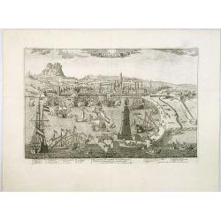
Seville. Ville Archiepiscopale et Capitale du Raume d'Andalousie en Espagne. . .
A very decorative and extremely rare view of Seville, including a numbered (1-37) key in the lower part. Published by Jacques Chéreau, (1688 - 1776). Engraved by Aveline...
- $2000 / ≈ €1871
Place & Date: Paris, ca.1750
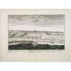
Barcelone, Ville Capitale de la principauté Catalogne. . .
A very decorative and scarce view of Barcelona, including a numbered key ( 1-29 ) in the lower part. Published by Jacques Chéreau, (1688 - 1776). Engraved by Aveline and...
- $2000 / ≈ €1871
Place & Date: Paris, ca.1750
Madrid Villa Capital Del Reyno D'Espana.. / Madrid ville capitale du Royaume d'Espagne . . .
A very decorative and scarce town view of Madrid, including a numbered key ( 1-17 ) in Spanish and French in the lower part. Published by Jacques Chéreau, (1688 - 1776)....
- $3000 / ≈ €2807
Place & Date: Paris, ca.1750

Carte de la Petite Tartarie Dresee par ordre de l'Imperatries de toutes las Russies.
The very rare first edition of De Leth's map of the southern part of Ukraine, with detailed annotations regarding the Cossacks and an explanatory key. Based on a Russian ...
- $1750 / ≈ €1638
Place & Date: Amsterdam, ca. 1785

Germania.
Second state of this rare "carte à figures"- map of Germany, The Netherlands, Poland and central Europe. Bordered on three sides with portraits and views. In t...
Place & Date: Amsterdam, 1607

Wittstocs.
Very decorative and rare panoramic of Wittstock, Bez. Potsdam.The engraver and publisher of prints, Mrs. Anna Beek of the Hague, enlarged the print and mounted it on larg...
Place & Date: The Hague, ca. 1642
![Bressia vulgo Bresse. [colored by Van Santen]](/uploads/cache/29235-250x250.jpg)
Bressia vulgo Bresse. [colored by Van Santen]
Title cartouche with putti and surveyor with surveying instruments. Upper right-hand corner Geneva, lower left Lyon and in the center Bourg-en Bresse. Upper right-hand co...
Place & Date: Amsterdam, 1650

North Pacific.
Huge three sheet so-called Blue-back sailing chart of the Northern Pacific including China, Korea (with Matu Is. and Liancourt), Japan, Philippines, Kamchatka, Hawaii, Al...
Place & Date: London, 1868

Eastern passage to China. sheet 1.
James Horsburgh early chart of the coasts of Java, Bali, Lombok, with part of Sulawesi, and Borneo. Insets of "Sketch of Bally Strait", Sketch of Lombock Strait...
- $2500 / ≈ €2339
Place & Date: London, 1824
![[MANUSCRIPT] Carte nouvelle de la Crimée et des pays circonvoisins.](/uploads/cache/30484-250x250.jpg)
[MANUSCRIPT] Carte nouvelle de la Crimée et des pays circonvoisins.
A beautiful manuscript map on paper. Showing the northern part of the Black Sea region with Crimea.Interesting are the border lines of "New Serbia", shown in th...
Place & Date: ca. 1752-1764

Nieuwe en zeer accuraate Zee-Caart van de Hollandse Wal strekkende van de Maas tot Texel opgenomen door Jan Rokusz Douw, , ,
A very fine and rare chart of the coast of Holland, Prepared by Jan Rokusz, Douw and Agge Roskam Kool.Embellished with a very decorative cartouche with a dedicational tex...
Place & Date: Amsterdam, 1750

Nouvelle et exacte description du globe terrestre reveue corrigée et augmente´e suivant les derniéres relations des Anglais et Hollandois. Par Guillaume Blaeu 1645.
Extremely rare and decorative "carte a figures" world map published by Anthoine de Fer. The double hemisphere world map is surrounded by constellations of the A...
Place & Date: Paris, 1645
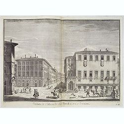
Veduta de' Palazzi de' Sig. March. Corsi e Viviani.
Lively street scene with several palaces in Florence after Giuseppe Zocchi (1711or 1717 - 1767) and engraved by Mich. Mariesschi and Vincenzo Francesschini. From "Sc...
- $450 / ≈ €421
Place & Date: Florence, Bouchard, 1754
![CH'ONHA CHIDO [Atlas of all under Heaven]](/uploads/cache/33625-250x250.jpg)
CH'ONHA CHIDO [Atlas of all under Heaven]
The Ch’onha chido [Atlas of all under Heaven] is a late 18th century copy of the traditional Korean atlas produced in the early Choson dynasty (1392-1910). One of the m...
Place & Date: Korea, ca. 1790

Mapa De la parte de la Isla Formosa sa perteneciente al Emperadotde la China sacado por Ord. De S.M.
Extremely rare map of the west coast of Taiwan, the Punghu or Pescadore Islands, and the Fokien or Fujian coast of China. Several ancient Taiwanese cities are noted, incl...
Place & Date: Manilla, Seminario Conciliar, y Real de San Carlos, 1788-1792
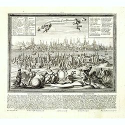
Constantinopolis Constantinopel.
Very rare and decorative panoramic view of Istanbul prepared by Friedrich Berhard Werner and published by Martin Engelbrecht. The engraving is done by Johann Georg Ringli...
- $3500 / ≈ €3275
Place & Date: Augsburg, M.Engelbrecht, ca.1730-1740

Vorstellung der Evangelisch-Ostindischen Kirche Augsburger Protestanten.
Very decorative and rare print to commemorate the 200 year Confession of the Augsburg Protestant Confession. Engraved by J. Kleinschmidt after a design of E. Ridinger.Dis...
- $1500 / ≈ €1404
Place & Date: Augsburg, 1732

Mare Balticum. . . / Nieuwe Pascaert van de Oost Zee. . .
Decorative chart showing the Baltic sea, with a splendid cartouche of royal figures. A re-issue of the De Wit copper plates, now with many improvements.
- $2500 / ≈ €2339
Place & Date: Amsterdam ca.1680

A plat of the East Sea. By William Fisher and Richard Mount...
An important sea chart of the East Sea with coast lines of Poland, Russia, Sweden, published by William Fisher and Richard Mount in London.Richard Mount (1654-1722) was a...
- $1800 / ≈ €1684
Place & Date: London, 1795
Tractus Danubii, Fluminis in Europa Maximi, A Fontibus, Per Germaniam. . .
This is Blaeu’s first map of the Danube and surrounding regions. The Danube River runs through the map from the top left with its headwaters in the German Black Forest ...
- $2000 / ≈ €1871
Place & Date: Amsterdam, 1634

Calecuty Regnum
A rare and unusual depiction of the Indian Ocean between Madagascar, Ethiopia, southern Arabia, and south India and Ceylon.The calligraphy is florid and decorative. The e...
- $2000 / ≈ €1871
Place & Date: Cologne, 1596
![ISLA DE CUBA [with 2 maps] Plano Pintoresco De La Habana con los numeros de las casas B. May y Ca. 1853. (with) Inset map Puerto y Cereanias De La Habana. (with) 14 views of Havana & prominent buildings.](/uploads/cache/36720-250x250.jpg)
ISLA DE CUBA [with 2 maps] Plano Pintoresco De La Habana con los numeros de las casas B. May y Ca. 1853. (with) Inset map Puerto y Cereanias De La Habana. (with) 14 views of Havana & prominent buildings.
Lithographic town-plan surrounded with views of the city of Havana including the "Fuente De La India En El Paseo De Isabel 2a." and "Vista Gral De La Haban...
Place & Date: Havana, 1853