Browse Listings
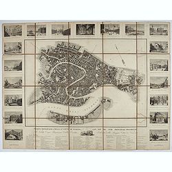
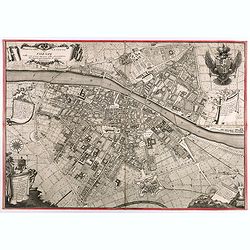
Pianta Topografica della R.a Città di Venezia con XIX de suoi principali prospetti.
A detailed town plan of Venice with an extensive key underneath and nineteen views of the important buildings among which : Piazza di S. Marco, Canal Grande, Tempio della...
Place & Date: Milan: Santo Vallardi, c.1840
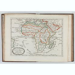
L'Affrique En Plusieurs Cartes Nouvelles, et exactes, &c.
Edition illustrated with 18 maps in original outline colors dated 1656. No date and title page and maps not numbered (according to Pastoureau 1 C, maps are numbered).Nico...
Place & Date: Paris, l'Auteur, after 1662
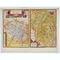
Burgundiae Ducatus. Burgundiae Comitatus.
Separately issued map of Burgundy area. Two maps of Burgundy region on a plate. Separately published map, without text on the verso. Second state with the date 1597 remov...
Place & Date: Antwerp, after 1612
Nova et integra caenomaniae descriptio vulg. Le Mans.
Fine separately issued example of Gerard De Jode's map of Caenomaniae (Maine Province), from his Speculum Orbis Terrarum. Gérard de Jode (1508? -1590) published in Antwe...
Place & Date: Antwerp, ca. 1593
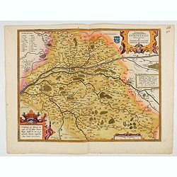
Touraine. Turonensis Ducatus.
Map of Touraine Duché in very fine original colours.
Place & Date: Antwerp, 1598
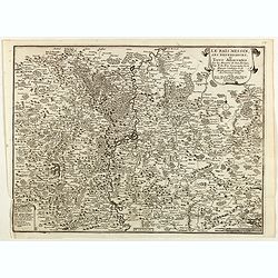
Le Païs Messin, ses dependances, et Terre Adiacentes.
Map of the Messin region, from Nicolas de Fer's "L'Atlas curieux ou le Monde réprésente dans des cartes. "The "Atlas Curieux" is a geographic encycl...
Place & Date: Paris, 1705
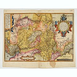
Westphaliae Totius, Finitimarumque Regionum Accurata Descriptio.
A very beautiful hand colored copper engraved map of North Rhein-Westphalia by A. Ortelius. This is a general map of Westphalia and the surrounding regions in northwest G...
Place & Date: Antwerp, ca 1584
![[Title page for] Partie des Forces de l'Europe. . .](/uploads/cache/47943-250x250.jpg)
[Title page for] Partie des Forces de l'Europe. . .
Very decorative title page from the rare Amsterdam edition of 1693 by Pieter Mortier (1661-1711) of de Fer's important work.Nicolas de Fer (1646-1720) was a cartographer,...
Place & Date: Amsterdam, 1693

Panache la nouvelle revue du Lido.
Very decorative poster designed by René Gruau for the Lido and its review Panache on the Champs Elysées, Paris. The bluebells are pictured for the 1985 show. René Grua...
Place & Date: Paris, ca. 1980
![[Title page for] Galliae tabule geographicae . . .](/uploads/cache/47941-250x250.jpg)
[Title page for] Galliae tabule geographicae . . .
Very fine title page by Gerard Mercator, composed of an elaborate strapwork design with the portrait of a King at the top.
Place & Date: Amsterdam, 1613
Souveraineté de Neuchatel et de Vallangin.
Map of the Neuchatel region, from Nicolas de Fer's "L'Atlas curieux ou le Monde réprésente dans des cartes. "The "Atlas Curieux" is a geographic enc...
Place & Date: Paris, 1705
![[Title page for ] Atlas Novus Terrarum orbis Imperia.](/uploads/cache/47938-250x250.jpg)
[Title page for ] Atlas Novus Terrarum orbis Imperia.
Title page from Atlas Novus printed by Johann Ernst Udelbulner. Large elaborately engraved sheet with numerous allegorical figures. A large globe, showing the Eastern Hem...
Place & Date: Nuremberg, 1732
![[Title page] Geographiae libri octo Graeco-Latini . . .](/uploads/cache/47936-250x250.jpg)
[Title page] Geographiae libri octo Graeco-Latini . . .
Fine decorative titlepage from the 1605 edition of Ptolemy. The plate is adorned with allegorical figures, fruits and architectural motifs. This 1605 edition was based on...
Place & Date: Amsterdam, 1605
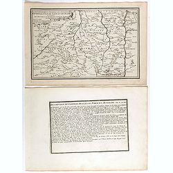
Les Provinces, ou Gouvernement de Poictou, d'Anjou, du Maine, De Touraine . . .
Map centered on Loire region, with Blois, Saumur, Sancerre and Orleans, from Nicolas de Fer's "L'Atlas curieux ou le Monde réprésente dans des cartes. "The &q...
Place & Date: Paris, 1705
![[Title page] De Praecipuis, Totius Universi Urbibus, Liber Secundus.](/uploads/cache/47934-250x250.jpg)
[Title page] De Praecipuis, Totius Universi Urbibus, Liber Secundus.
Allegorical title page, from Volume 2 of Braun & Hogenberg's Civitatus Orbis Terrarum.At the top are figures representing Religion and Politics, placed on either side...
Place & Date: Cologne, 1582
Pianta Della Citta di Firenze nelle seu vere misure colla descrizione dei luoghi piu notabili di ciascun Quartiere.
A highly decorative plan of Florence by Ferdinando Ruggieri. In addition to the detailed plan of the City, it includes fine decorative embellishments and demonstrates the...
Place & Date: Florence, 1755
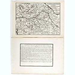
Gouvernement general du Lionnois, generalitez de Lion et de Riom . . .
Map of central France with Clermont-Ferrand and Lyon to the right, from Nicolas de Fer's "L'Atlas curieux ou le Monde réprésente dans des cartes. "The "A...
Place & Date: Paris, 1705

La Nuova Olanda e La Nuova Guinea delineate sulle ultima osservazioni.
Cassini’s splendid and rare map of Australia and New Guinea, from the 'Nuovo Atlante Geografico Universale'. The emphasis of the map is the charting of Captain Cook dow...
Place & Date: Rome, 1798
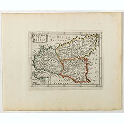
Le Royaume de Sicile.
Uncommon map Sicily and part of Palermo. Very good impression.Like Sanson, Briet was born in Abbeville and became a Jesuit at age 18. His "Parallela Geographiae Vete...
Place & Date: Paris, 1653
![Le Isole di Sandwich delineate sulle osservazioni del Cap Cook. [Hawaii]](/uploads/cache/43195-250x250.jpg)
Le Isole di Sandwich delineate sulle osservazioni del Cap Cook. [Hawaii]
FIRST EDITION on laid paper. Cassini’s splendid map depicts Sandwich islands, old name for Hawaii islands, at the end of the eighteenth century. The splendid cartouche ...
Place & Date: Rome, 1798
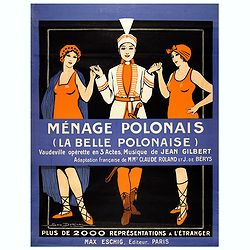
Ménage Polonais (La belle Polonaise) - Vaudeville opérette en 3 actes. Musique de Jean Gilbert.
Original advertising poster for the operetta " Ménage Polonais ". Title translation " Polish household " Ménage Polonais (The beautiful Polish) - Va...
Place & Date: Paris, 1914
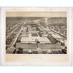
Souvenir de Paris.
Decorative bird's-eye view of the current Louvre Museum, with river Seine and the Notre Dame cathedral on the right. of Paris. After a design by P. St. Martin.
Place & Date: Paris, ca. 1858
Plan de la ville et du château de Caën en Normandie.
Plan of the city of Caen, from Nicolas de Fer's "L'Atlas curieux ou le Monde réprésente dans des cartes. "The "Atlas Curieux" is a geographic encycl...
Place & Date: Paris, 1705

Carte des Possessions Françoises et Angloises dans le Canada, et partie de la Louisiane.
First state of this separately published map of the European Colonies in the New World east of the Mississippi River. This map was published in 1756 to provide informatio...
Place & Date: Paris, 1756
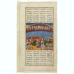
Double page manuscript page from a Shahnameh, The Book of Kings, written by Ferdowsi.
Fine double page brilliantly illuminated gilt leaves written by the scribe Abu Bakr Jami in Isfahan. The Arabic text contains Islamic prayers with beautiful headings thro...
Place & Date: Isfahan, ca. 1780
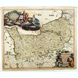
Nova et accurata Normandiae Ducatus Tabula . . .
This very rare map of Britany made by the Amsterdam publisher and Pieter Persoy (1675-1695). This among fourteen other maps are sometimes found in atlases by Frederik de ...
Place & Date: Amsterdam, 1730

Air France Rayonne sur le monde.
Advertising poster from Air France, the french airline company. The poster has always occupied a special place in Air France's communication. With a heritage of more than...
Place & Date: Imprimerie Goosens, Paris, ca. 1940-1950
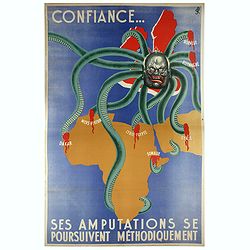
Confiance... Ses Amputations se Poursuivent Methodiquement.
Propaganda poster, produced under the NAZI collaborating Vichy French regime and designed to inspire revulsion and hatred of the English among the French, while frequentl...
Place & Date: Paris, ca. 1941
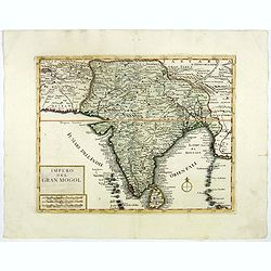
Impero del Gran Mogol.
A very fine map showing India divided into its regions with major towns and cities marked and also parts of its neighbouring kingdoms.
Place & Date: Venice, 1740
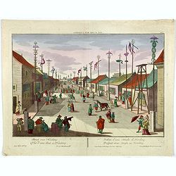
Vue d'une Rue Nanking.
A well-known publisher of optical prints, established in Augsburg. After a design by P.van Blankaert.In the eighteenth and nineteenth centuries, there were many popular s...
Place & Date: Augsburg 1760

(Publicity mini poster) Riz Soleil Levant.
Original stone lithograph in-store small format display for Riz Soleil Levant, or basically Rice of the Rising Sun.The Chinaman is pouring a box of this rice over the ima...
Place & Date: Paris, ca.1933
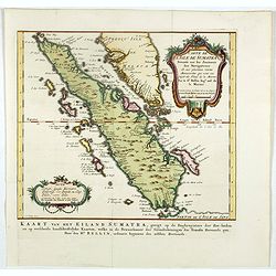
Carte de l'Isle de Sumatra. . . / Kaart van het Eiland Sumatra. . .
Map of Sumatra, also showing the tip of the Malay Peninsula and the Straits of Singapore. An unusually detailed map of the area, showing many coastal features, shoals, ba...
Place & Date: The Hague, Pierre d'Hondt, 1753
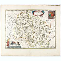
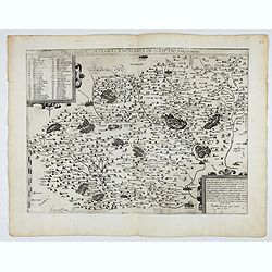
Cadurcium Vernaculé Querci.
Detailed map of a province of France by one of the most famous map publisher. Centered on Cahors.In the lower-left corner, a colored scale cartouche surmounted by a monke...
Place & Date: Amsterdam, 1644
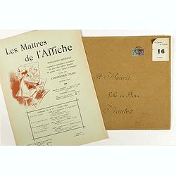
Sommaire du n°16 - Mars 1897
Cover of Les Maitres de l'Affiche n°16 (2nd year of publication). It used to contains the plates 61 - 64. The "Les Maitres de l'Affiche" contained 256 small fo...
Place & Date: Paris, Imprimerie Chaix, August 1897
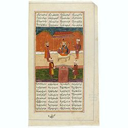
Manuscript page from a Shahnameh, The Book of Kings, written by Ferdowsi.
Page with large miniature 187 x 160mm. from the Shahnameh, or ("The Book of Kings"), which is a long epic poem written by the Persian poet Ferdowsi between c. 9...
Place & Date: Kashmir, ca. 1830-1860
Manuscript page from a Shahnameh, The Book of Kings, written by Ferdowsi.
Page with large miniature 160 x 160mm. from the Shahnameh, or ("The Book of Kings"), which is a long epic poem written by the Persian poet Ferdowsi between c. 9...
Place & Date: Kashmir, ca. 1830-1860
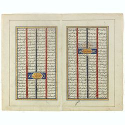
Double page manuscript page from a Shahnameh, The Book of Kings, written by Ferdowsi.
Fine double page brilliantly illuminated gilt leaves written by the scribe Abu Bakr Jami in Isfahan. The Arabic text contains Islamic prayers with beautiful headings thro...
Place & Date: Isfahan, ca. 1780

(Art déco gouache)
Outstanding "art deco" gouache (unsigned) from the workshop of "Robert Pichon. Ateliers de Dessin et Lithographie – 10, rue Rochechouart – Paris. The g...
Place & Date: Paris, ca. 1930
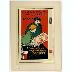
Wilhem Hoffmann Dresden.
Chromo lithographed poster, "Wilhelm Hoffmann Dresden.", after Otto Fischer. Plate 127, published in Maître 32, on July 1898. The "Les Maitres de l'Affich...
Place & Date: Paris, Imprimerie Chaix, April 1896
Selling price: $100
Sold in 2017
Nova Haec tabula Galliae. . .
Dated 1653. This handsome map of France is dedicated to Louis XIV, interesting in light of the nearly constant warfare between Louis and the Netherlands in the ensuing ye...
Place & Date: Amsterdam, 1653

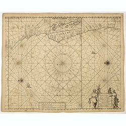
The Sea Coast of France from Ushent to Olone.
Chart showing the Brittany coast from Ushent to Ollone, with Belle-Ile. In insets : Rade de Brest and Mouth of the Loire between St. Nazaire and Nantes.Originally engrave...
Place & Date: London, ca. 1680

Pascaerte vande Vlaemsche, Soute, en Caribesche Eylanden, als mede Terra Nova,. . .
This fine and scarce sea chart covers the central Atlantic and extends to include the Maritime Provinces, Antilles and the northwest coast of South America, east to the A...
Place & Date: Amsterdam, 1672
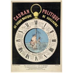
Cadran Politique au casque magique de guillaume.
A rare broad sheet about the Franco-Prussian War. Showing a large clock with in the center William I, the German Emperor, surrounded by 12 stages of the war.Printed by Gi...
Place & Date: Paris, c.1872
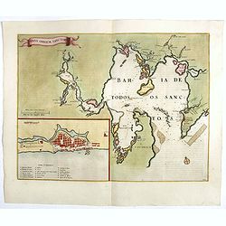
Sinus Omnium Sanctoru. Bahia de Todos os Sanctos.
RARE. First Atlas Major issue: originally issued by Blaeu in Casper van Baarle's 'Rerum per Octennium in Brasilia' (1647) dedicated to the former Governor of the Dutch co...
Place & Date: Amsterdam, 1664
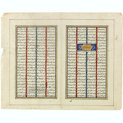
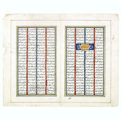
Double page manuscript page with Islamic prayers with beautiful headings throughout.
Fine double page brilliantly illuminated gilt leaves written by the scribe Abu Bakr Jami in Isfahan. The Arabic text contains Islamic prayers with beautiful headings thro...
Place & Date: Isfahan, ca. 1780
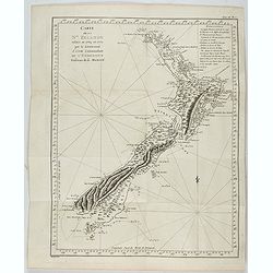
Carte de la Nouvelle-Zelande visitée en 1769 et 1770 par le Lieutenant J. Cook.
Original French Edition of James Cook's Chart of New Zealand, from the First French Edition of Hawkesworth's Voyages. Map of New Zealand, engraved by Bernard. The most im...
Place & Date: Paris, 1774
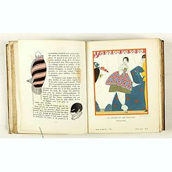
Gazette du Bon Ton Art - Modes Frivolités. (1912/1913 volume)
La Gazette du Bon Ton was a leading French fashion magazine that was published from November 1912 to 1925. The extremely rich and vivid colors were achieved through the l...
Place & Date: Paris, 1912-1913
Pascaart van de zee-custenvan Angola, en Cimbedas van Rivier de Galion tot C. de Bona Esperanca.
Rare Doncker's sea chart of the West Coast of Africa, from Angola to the Cape of Good Hope, with a larger inset map of the area from St. Martin's Bay to the Cape of Good ...
Place & Date: Amsterdam, 1660-1668
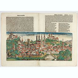
Bamberga. Folium CLXXV
Double page panoramic view of Bamberg. One of the earliest obtainable view of this period.Two page from the richest illustrated Incunable, the famous: Nuremberg Chronicl...
Place & Date: Nuremberg, 12 July 1493
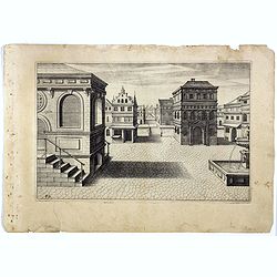
Perspective print by Vredeman de Vries. 42.
Engraving from Perspective, c'est a dire, le tresrenomme art du poinct oculaire d'une veue dedans ou travers regardante, estant sur une muraille unie, sur un tableau, ou ...
Place & Date: The Hague, 1604 - 1605

The Sea Coasts of France from Olone to Cape Machicaca in Biscay . . .
Detailed chart of Biscay Bay, showing the Coast of Brittany. The chart is oriented with north-east at the top and includes two large insets of the Loire River with Nantes...
Place & Date: London, ca. 1680
Comitatus Zutphania.
With an inset a plan of the town of Zutphen. Originally published by Petrus Kaerius in 1617. Published by Visscher in his "Belgium sive Germania Inferior continens p...
Place & Date: Amsterdam, 1634

French composite atlas made up of rare maps published by Parisian editors from the 17th century , mainly by G. Jollain including scarce maps of America.
A rare French composite atlas including 90 maps, published by Parisian publishers from the 17th century, mainly by Gérard I Jollain, or by maps bought from Dutch publish...
Place & Date: Paris, ca. 1675

Wo ai bei jing tian an men. - I Love Peking's Tie An Men. - Ich Liebe Tienanmen in Peking. - J'aime la Porte Tien an-men de Pékin.
colored Chinese Cultural Revolution poster, featuring three joyful young children looking at a drawing of a young boy on a aeroplane heading towards Tiananmen Square. The...
- $200 / ≈ €187
Place & Date: Shaanxi renmin chubanshe, Shanhai / Beijing, ca. 1968
![Shang dang ke (xuan zi Huxian nong min hua zhan]. (Party-lecture Education)](/uploads/cache/42021-250x250.jpg)
Shang dang ke (xuan zi Huxian nong min hua zhan]. (Party-lecture Education)
Chinese political poster in color depicting eleven peasants gathered in a room to listen to a Party supported lecture in Northwest China. The man next to the blackboard g...
- $200 / ≈ €187
Place & Date: Shanghai renmin chubanshe, 1974/1975
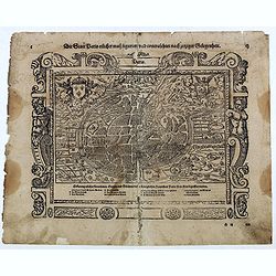
Die Statt Paris etlicher mass figuriert und contrafehtet nach jetziger Gelegenheit.
Published in the "Universal Cosmography" of S. Münster. Text in German. Under the legendary plan in German A to G. It is framed by a border composed of foliage...
- $200 / ≈ €187
Place & Date: Bâle, H. Petri, 1578
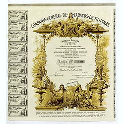
Compañia General de Tabacos de Filipinas (Certificate).
Decorative certificate with a decorative vignette and map / globe oriented to show the Philippines.Tabacalera was the popular name of Compañia General de Tabacos de Fili...
- $80 / ≈ €75
Place & Date: Barcelone, 1969

Lido de Paris - Nouveau spectacle Christian Clerico présente C'est magique.
Very decorative poster designed by René Gruau for the Lido, made on the occasion of the release of the new show "It's magic". René Gruau (1909-2004) was a Fra...
- $300 / ≈ €281
Place & Date: Paris, ca. 1980

China Southeast Coast.
A very large US Army and Naval map of the south east coast of China, published during the second world war. Map extent is from Kweichow Province in the west, to Kwangsi P...
- $1250 / ≈ €1170
Place & Date: [New York], 1944
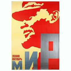
Lenin October.
Uncommon Soviet propaganda poster.Read more about the Soviet propaganda poster. [+]
- $200 / ≈ €187
Place & Date: Moscow, 1987

Accuratissima et maxima totius Turcici Imperii..
Rare issue of T. Danckert's attractive map showing the Arabian Peninsular, Turkey, Cyprus, Egypt and eastern part of the Mediterranean.Decorative title cartouche lower le...
- $1100 / ≈ €1029
Place & Date: Amsterdam, 1700

Pas kaart Van Rio Oronoque Golfo De Paria met d'Eylanden Trinidad, Tabago, Granada, Granadillos, en Bequia . . .
A highly detailed and rare sea chart of the mouth of the Orinoco River, Trinidad, Tabago, St.Vincent and neighboring islands. Oriented with north to the right by two comp...
- $900 / ≈ €842
Place & Date: Amsterdam, 1684
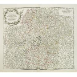
Cercle de Franconie . . .
Finely and crisply engraved map of part of Germany. Map by Giles Didier Robert De Vaugondy with erased title cartouche. Ornamental title cartouche in the upper part of ma...
- $80 / ≈ €75
Place & Date: Paris, 1752
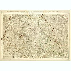
Partie Méridionale de l'Archevesché et Eslectorat de Cologne. . .
Fine map of the Westphalia, the area in-between the Rivers Maas and Rhine.
- $50 / ≈ €47
Place & Date: Paris, 1707

Connecticut and Parts adjacent at Amsterdam. .
A nice example of this early map of the state of Connecticut with part of Rhode Island to the east, Long Island to the south, and New York to the east. Rivers, roads, t...
- $30000 / ≈ €28072
Place & Date: Amsterdam, 1780
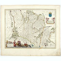
Belsia vulgo La Beausse.
In the left-hand lower part of the image a beautiful contemporary cartouche with goddess Ceres [agricultural] holding a reaping-hook in her right hand and receiving with ...
- $200 / ≈ €187
Place & Date: Amsterdam , 1644
La Flamboyante Colomne des Pays-Bas. Autrement dict les XVII Provinces. Chez Jacob Colom.
Rare atlas of the Low Countries, by Jacob Colom, in an early – first- French edition. The atlas was first printed in Dutch (1635) and than in 1636 in French, using the ...
- $3000 / ≈ €2807
Place & Date: Amsterdam, 1636
![Lovenstein. [Loevestein]](/uploads/cache/13749-250x250.jpg)
Lovenstein. [Loevestein]
View of the castle Loevestein, near Gorinchem.. On the sky, three hands holding a quill, a stone and a stick are depicted. With a verse in two languages underneath the pi...
- $60 / ≈ €56
Place & Date: Frankfurt, 1624
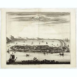
La Ville et le Château de Zélandia dans l' île de Tayovan.
This important copperplate engraving is one of the earliest European views of Taiwan, depicting the Dutch fortifications and trading settlement on the West coast of the i...
- $1800 / ≈ €1684
Place & Date: Amsterdam, 1675

Croquis Parisians - ''A LA RECHERCHE D'UN DINER. - Monsieur ne dine pas chez lei.. - Pas possible!... --- Oh! pour le coup, on dine dans cite Maison ci!
Second state (of 3), with text. From "Croquis Parisiens". Text below image :A LA RECHERCHE D'UN DINER. - Monsieur ne dine pas chez lui.. - Pas possible!... --- ...
- $150 / ≈ €140
Place & Date: Paris, after 1855

The theory and practice of layout en Page.
The First English Edition of the lavishly printed Bible of "Moderne", soon to be called art deco. Thanks to Tolmer's work the deco style persisted until the Sec...
- $1100 / ≈ €1029
Place & Date: London, The Studio, 1931
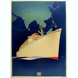
Poster, rare state before text . HAPAG
Original art deco cruise ship travel poster promoting HAPAG Line to Colombo, Singapore, Manilla, Hong Kong, Shanghai, Kobe and Yokohama. Great illustration by the German ...
- $1250 / ≈ €1170
Place & Date: Hamburg, ca. 1935
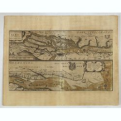
Celeberrimi Fluvis Albis nova delineatio. . .
A decorative map from a 1640's Latin text edition of Blaeu's "Theatrum Orbis Terrarum, Sive Atlas Novis." The River Elbe is depicted in two sections from the mo...
- $80 / ≈ €75
Place & Date: Amsterdam, 1644
![[Dutch ship Amsterdam].](/uploads/cache/37948-250x250.jpg)
[Dutch ship Amsterdam].
Text engraving of the Dutch vessel Amsterdam offshore the island of Java near Surabaya from "Premier livre de l'histoire de la navigation aux Indes Orientales, par l...
- $150 / ≈ €140
Place & Date: Amsterdam, Cornille Nicolas, 1609
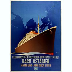
Regelmässiger passagier - und - fracht - dienst nach Ostasien Hamburg - Amerika Linie. (HAPAG)
Original art deco cruise ship travel poster promoting HAPAG Line to Colombo, Singapore, Manilla, Hong Kong, Shanghai, Kobe and Yokohama. Great illustration by the German ...
- $1900 / ≈ €1778
Place & Date: Hamburg, ca. 1935
![Ansicht von Megasaky. [Nagasaki - title also in Russian characters]](/uploads/cache/24829-250x250.jpg)
Ansicht von Megasaky. [Nagasaki - title also in Russian characters]
The print shows Nagasaki harbor with n the foreground the Russian delegation with Krusenstern in a boat with 3 Chinese. Japanese junks and the town of Nagasaki in the ba...
- $1500 / ≈ €1404
Place & Date: St.Petersburg, 1810-1814
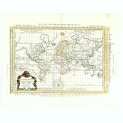
Il Mappamondo o sia Descrizione Generale del Globo Ridotto..
Attractive Italian map presented on Mercator's projection and featuring the voyages of Cook and Bougainville. Greenland is shown connected to North America and Alaska is ...
- $750 / ≈ €702
Place & Date: Venice, 1774
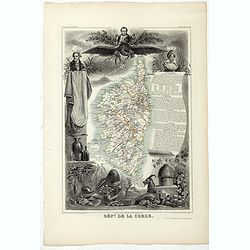
Dépt. De La Corse. N°19.
Map of the Corsica island.Lovely map from one of the last decorative atlases of the nineteenth century.The rather simple map is framed by elaborate border showing regiona...
- $150 / ≈ €140
Place & Date: Paris, A. Combette, 1852
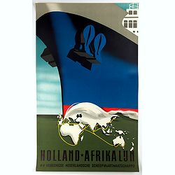
Holland-Afrika Lijn.
Original cruise ship travel poster promoting Holland-Afrika Lijn for the N.V. Veenigde Nederlandse Scheepvaarts Maatschappij. Great illustration by the Dutch graphic arti...
- $850 / ≈ €795
Place & Date: Rotterdam, Kuhn & Zoon, ca. 1960

Avantures du Sr. C. Le Beau, avocat en parlement ou Voyage curieux et nouveau parmi les Sauvages de l'Amérique Septentrionale. Dans lequel on trouvera une Description du Canada… Ouvrage enrichi d'une Carte et des figures necessaires.
A description of Huron, Iroquois, and Algonquin customs, written in charming style and based, the Author claims, on observations made on a trip to America in 1729." ...
- $2500 / ≈ €2339
Place & Date: Amsterdam, 1738