![[Manuscript chart on vellum of the Java Sea]](/uploads/cache/33613-250x250.jpg)
[Manuscript chart on vellum of the Java Sea]
One of the few manuscript charts on vellum in private hands, signed by Isaac de Graaf. ORIGINAL MANUSCRIPT MAP IN RED, GREEN AND BLACK INK showing the Java Sea centered o...
Place & Date: Amsterdam, 1743

Universe Europae Maritime Eiusque Navigationis Descriptio. Generale Pascaerte van Europa . . .
This general chart of north-western Europe and the surrounding coastal waters is from the rare pilot-guide De Spiegel der Zeevaerdt , printed by Christopher Plantin in Le...
Place & Date: Leyden, 1584

Carta prima Generale dell' Asia.
FIRST STATE of Robert Dudley's general chart of the Persian Gulf, going east through India to the southeastern coast of China showing Macau and the area of present-day Ho...
Place & Date: Florence, 1646

Neptune des Côtes Occidentales de France.
Large maritime atlas illustrated with a handwritten title, a table and 47 single or double page charts. The charts show the western coasts of France as well as the Spanis...
- $12000 / ≈ €11229
Place & Date: Paris, 1776-1822

Hydrograhica descriptio
This very rare chart is important as the first printed sea chart of the Mediterranean coast of Spain, Gibraltar, also depicting the northern coast of Marocco.Willem Bar...
Place & Date: Amsterdam, W.Blaeu, 1612

(Sea-chart of Catalunia, Languedoc, Provence, Cote d'Azur, Riviera, Corsica with Marseille, Cannes, Nice, Monaco.)
This very rare chart is important as the first printed sea chart of France's Mediterranean coast, also depicting Catalunya's northern coast, the Italian Cote d'Azur till ...
Place & Date: Amsterdam, 1607

Pascarte van Europa Beginnende vande Canael tot aen Spitbergen, en van Ysland tot aen Nova Zemla . . .
An eye-catching chart of northern Europe with a coastline from northern Russia to the Dutch English Channel in the south. Good detail on Iceland. North to the top.In the ...
Place & Date: Amsterdam, after 1666

Zee caerte vande Sondt tvermaerste van Danemarcke . . .
A detailed chart of the coast of Denmark and its islands, Copenhagen in the center of the chart. West to the top. It is decorated by a title, scale and descriptive cartou...
Place & Date: Leiden, Plantijn, 1585

Belchrijuinghe vande zee custen van Engelandt. . .
A rare Dutch text edition of this detailed early chart of the northern coast of England. West to the top. The mileage cartouche has no Latin captures. Decorated by a colo...
Place & Date: Leiden, Plantijn, 1585

De zee cuften tufschen Dovere en Orfords nesse, daer de Teemse de Vermaerde Rivire van Lonen gelegens is. . .
A detailed chart of the English Channel coastland. Decorated by a colorful title cartouche and scale cartouche, one compass rose, several vessels and sea monsters. A very...
Place & Date: Leiden, Plantijn, 1585

Beschrijvinge vande de zee Cuften va Vlanderen en Picardien. . .
DUTCH TEXT EDITION. A detailed chart of the coast of Flanders and Normandy decorated by a large colorful baroque title cartouche, and the coat of arms of Flanders with a ...
Place & Date: Leiden, Plantijn, 1585

Pascaerte van Brazil en Nieu Nederlandt van Cuorvo en Flores.
A rare chart of the Atlantic Ocean from the first edition of Hendrick Doncker's Zee-Atlas, of which no surviving example is known.Although the idea of its unusual coverag...
Place & Date: Amsterdam, 1658

Pascaerte Van't Westelyckste der Middelandsche Zee. . .
An eye-catching chart of the western part of the Mediterranean Sea.Pieter Goos (ca. 1616-1675) was one of the most important cartographer, engraver, publisher and print s...
Place & Date: Amsterdam, 1666
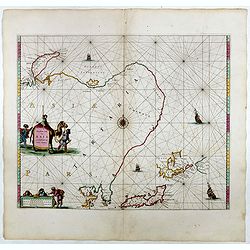
Noordoost Cust van Asia van Japan tot Nova Zemla.
An eye-catching chart of Hokkaido and the Islands to the North of Japan. Ships navigate the seas around the Siberian, Chinese and Japanese coasts extending as far west as...
- $2500 / ≈ €2339
Place & Date: Amsterdam, 1666
Insulae Iavae Cum parte insularum Borneo Sumatrae..
An elegant sea chart of the island of Java with parts of Sumatra, Borneo and Bali. The map includes only coastal detail and shows the Dutch capital in the East Indies at ...
Place & Date: Amsterdam, 1652

Mappa Aestivarum Insularum alias Barmudas.
Blaeu based his work on John Speed's remarkably accurate map of 1626-1627. It shows the island divided into tribes and lots, and below the map itself appear the names of ...
- $2200 / ≈ €2059
Place & Date: Amsterdam, 1662

Pascaerte vande Vlaemsche, Soute, en Caribesche Eylanden, als mede Terra Nova,. . .
This fine and scarce sea chart covers the central Atlantic and extends to include the Maritime Provinces, Antilles and the northwest coast of South America, east to the A...
Place & Date: Amsterdam, 1672

Carte de l'Ile de Java. . .
An inset plan of Batavia and clearly indicated rice fields, mountains, forests, towns in profile, and even elephants, suggesting the wealth of detail found on this map. M...
Place & Date: Amsterdam, 1720

Carta particolare che comincia con il c.apo Aldea è Finisce con il capo Degortam. . .
Dudley’s magnificent chart shows the south west coast of Africa. A first edition without the privilege..Engraved by Lucini.Sir Robert Dudley's Dell'Arcano del Mare is t...
- $1250 / ≈ €1170
Place & Date: Florence, 1645

Insulae de Cabo Verde olim Hesperides sive .. Zoute Eylanden.
Original copper engraving, hand colored in outline, when published. Double page chart covering detailed the Cap Verde Islands in the Atlantic Ocean (Isla de San Antonia, ...
Place & Date: Amsterdam, 1655

Paskaert vande Bocht van Vranckrijck Biscajen. . .
An eye-catching chart of the coast of Bretagne from Brest running south till the coast of Biscay in Northern Spain.Including the towns of Ferrol in the west, Gijon, Santa...
Place & Date: Amsterdam, after 1666

Cust van Hollant Tussen de Maes ende Texel.
Uncommon chart of the coast of Holland, including the southern tip of Texel. East at the top. Two fine compass cards, soundings and a large Bree Veerthien offshore.Piete...
Place & Date: Amsterdam, 1666
![De Texel Stroom met de gaten vant Marsdiep. [with] Caarte van De Mase ende het Goereesche Gat.](/uploads/cache/12097-250x250.jpg)
De Texel Stroom met de gaten vant Marsdiep. [with] Caarte van De Mase ende het Goereesche Gat.
Two decorative charts on one sheet, one depicting Texel and the entrance of the Zuider Zee with an inset showing the north coast of West-Friesland, the other depicting th...
Place & Date: Amsterdam, 1660
Ware affbeeldinge wegens het casteel ende stadt Batavia. . .
A reduced version of Clement de Jonghe (1650) plan of Jakarta from 1650. The town plan has a vignette at the bottom showing Jakarta from the sea with the volcanoes Mount ...
- $800 / ≈ €749
Place & Date: Leiden, 1719

Cimbebas et Caffariae Littora a Catenbela ad Promontorium. . .
The coast of Angola, South-West Africa and South Africa up to Port Elizabeth. Classic sea chart of Dutch school with excellent baroque embellishment. North oriented to th...
- $750 / ≈ €702
Place & Date: Amsterdam, 1675

De Cust van Barbaryen van out Mamora tot Capo Blanco..
Six charts on one sheet. The two upper charts covering an area from Cape Blanc to Casablanca. In lower part four insets with detailed charts of islands as Madera, Porto S...
Place & Date: Amsterdam, 1666

De Cust van Barbaria, Gualata, Arguyn, en Gene..heo, van Capo S.Vincente tot Capo Verde.
An eye-catching chart of the north western coast of Africa. Including Canary Islands, Cape Verde Islands and Azores.Pieter Goos (ca. 1616-1675) was one of the most import...
Place & Date: Amsterdam, 1666

Pas-Caart van Guinea en den Custen daer aen gelegen Van C..
A decorative chart of the southwest coast of Africa, embellished with an elaborate, finely colored title-cartouche, and 2 compass-roses. Pieter Goos (ca. 1616-1675) was o...
Place & Date: Amsterdam, 1666

Pas kaart vande Zuyd kust van Cuba en van Geheel Jamaica…
A nautical chart covering the southern part of Cuba, all of Jamaica and the western tip of Hispaniola and a bit of the Honduras coastline. Insets of "Baya Oristan in...
Place & Date: Amsterdam, J. van Keulen, 1697-1709
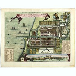
![[View of the arrival of Cornelis de Houtman's fleet at Bantam, Java.].](/uploads/cache/37937-250x250.jpg)
[View of the arrival of Cornelis de Houtman's fleet at Bantam, Java.].
Engraved map of Bantam on Java with a lettered key (A-N) showing the arrival of Cornelis de Houtman’s fleet at Bantam, Java in 1596. Houtman’s four vessels, the Amste...
- $200 / ≈ €187
Place & Date: Amsterdam, Cornille Nicolas, 1609
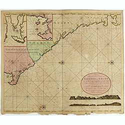
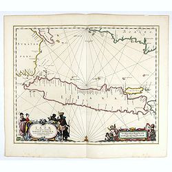
Nieuwe Paskaert van de Custen Zee Loango en Angoy van C. de Lopo Gonzalves tot R. de Zaire os Congo vertoonende alle desselfs gelegenteden.
Sea-chart of the coast of Gabon, Loango, Angoy and Angola to Zaire (Congo) River. In lower right side title and two coastal profiles. In upper left corner inset charts of...
- $300 / ≈ €281
Place & Date: Amsterdam, ca. 1715 -1751

Paskaart van de kust van Maroca beginnende van Larache tot aan C. Cantin. . .
A nautical sea chart of the coast of Morocco. Insert at top right: 'Nieuwe Afbeelding van de Rivier Rio Rebata in 't Groot".Bottom right: chart number '32'. Compass ...
Place & Date: Amsterdam, ca.1682
![[Foreign Merchants at Bantam].](/uploads/cache/37943-250x250.jpg)
[Foreign Merchants at Bantam].
Two text engravings from "Premier livre de l'histoire de la navigation aux Indes Orientales, par les hollandois, et des choses a eux advenues . . . ", being the...
- $100 / ≈ €94
Place & Date: Amsterdam, Cornille Nicolas, 1609