Browse Listings in Map Types > Curiosities general

L'Homme A La Boule.
Satirical print in which Count Otto von Bismarck balances on the world with one spurred foot entering France, and wearing only his underpants which are marked with the Ge...
Place & Date: Paris, 1870-1871

L'Homme A La Boule.
Satirical print in which Count Otto von Bismarck balances on the world with one spurred foot entering France, and wearing only his underpants which are marked with the Ge...
Place & Date: Paris, 1870-1871
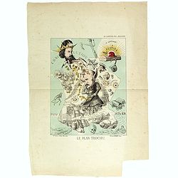
Le plan Trochu.
Lithography showing a map of France with a caricature of General Trochu and other scenes imposed on it. Designed by the French caricaturist Evrard, Emile , with his initi...
- $750 / ≈ €702
Place & Date: Paris, 1871
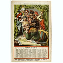
Gli observatori di un osservatore. Papagallo N°48.
Showing Bismarck studying a map of Europe. Taken from the Italian satirical newspaper "Il Papagallo", this plate N°48 has a descriptive text, in Italian langua...
- $600 / ≈ €561
Place & Date: Bologne, 1873

La Pieuvre Germanique.
Scarce lithographed plate not dated, by Eugène Danzanvilliers, printed by Grandremy in Paris. The plate listed by Adhemar is dated 1874. Eugène Danzanvilliers was a dra...
Place & Date: Paris, 28 Quai de la Rapée, c.1874

La pericolante ostinata. Papagallo No. 20 Anno II.
Design by Augusto Grossi. Taken from the Italian satirical newspaper Il Papagallo, a satirical magazine founded in January 1873 by Augusto Grossi (1835-1919), which speci...
Place & Date: Bologne, 1874

Trop d'Appetit par A. Le Petit.
Dated in lower right dated "Le 9 juin 1875". The drawing is representing an alligator's jaw wearing a Prussian helmet, and about to chew a globe. Alfred Le Peti...
Place & Date: Paris, 1875
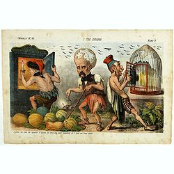
I tre diogene. Papagallo No. 43. Anno V.
Satirical lithographed plate published in the supplement to the political newspaper charivaric Papagallo / Le Perroquet N. 43, in the 5th year, published in Bologna. Sati...
Place & Date: Bologne, 1877

Un Reclutatore in India. Papagallo No. 42. Anno VI.
British in India. Design by Augusto Grossi. Taken from the Italian satirical newspaper Il Papagallo, a satirical magazine founded in January 1873 by Augusto Grossi (1835-...
Place & Date: Bologne, 1878

La Piovra Russa. Carta Serio-Comica Pel 1878.
Very rare political caricature map by Grossi of the nations of Europe, published in Bologna in the supplement of the newspaper "Le Perroquet / Al papagallo, N° 15, ...
Place & Date: Bologne, 14 avril 1878
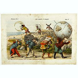
Pesi Graditi ee sgraditi. Papagallo No. 6. Anno VI.
Translation of the legend: "Several weights, each one has to carry its weight, the more serious it is, the longer the trip seems to be, and they will come sooner or ...
Place & Date: Bologne, 1878
![Jules Verne Le Tour du Monde en 80 jours. [Goose game board inspired by Jules Verne's novel Tour du Monde en 80 jours.]](/uploads/cache/44919-250x250.jpg)
Jules Verne Le Tour du Monde en 80 jours. [Goose game board inspired by Jules Verne's novel Tour du Monde en 80 jours.]
Goose game board inspired by Jules Verne's novel, whose boxes are illustrated with color lithographs and the center occupied by a world map. Vignette illustrations number...
Place & Date: Paris, ca. 1880
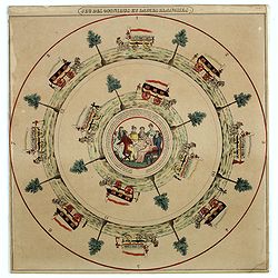
Jeu des omnibus et dames blanches.
The name of 'Dames Blanches', or white ladies, was bestowed on the two-compartment public omnibus that plied the Madeleine-Bastille run in Paris. In 1937 the brand Hermè...
- $250 / ≈ €234
Place & Date: Paris, ca 1880
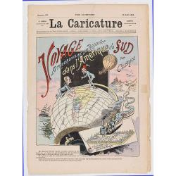
Voyage extraodinaire d'un reporter dans l'Amérique du Sud par Clérice (Front page of la Caricature n°137).
Frontispiece showing a globe with south America and the title "Voyage extraodinaire d'un reporter dans l'Amérique du Sud par Clérice". The newspaper contains ...
- $150 / ≈ €140
Place & Date: Paris, La Caricature, August 12, 1882
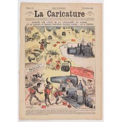
Enquête sur l'état de la civilisation en Europe. (Front page of la Caricature n°140).
The newspaper contains eight pages with different illustration. The artist is A. Robida, who was the chief editor and the engraver is Yves BarretThe artist is A. Robida, ...
- $100 / ≈ €94
Place & Date: Paris, La Caricature, September 2, 1882
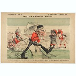
Politica Maramea Inglese - Rugantino - n°419 - Roma 17 Gennaio 1892.
Satirical print relating to the British Conquest of Egypt (1882), also known as Anglo–Egyptian War, between Egyptian and Sudanese forces under Ahmed ‘Urabi and the Un...
Place & Date: Rome, January 17, 1892
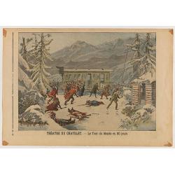
Le Petit Journal Illustré N°382 - Attentat contre le roi de Grece - Théatre du Chatelet: Le Tour du Monde en 80 jours.
Double page taken from the famous newspaper Le Petit Journal Illustré N°382, showing the attack against the king Georges of Greece (Size of the illustration: 305mm x 26...
- $30 / ≈ €28
Place & Date: Paris, 1898
![Drehbare Tasschen Sternkarte Brieftasche Format . . . [Calendrier perpetuel]](/uploads/cache/44965-250x250.jpg)
Drehbare Tasschen Sternkarte Brieftasche Format . . . [Calendrier perpetuel]
Calendrier perpetual prepared and published by Otto Maier in Regensburg. This "Rotatable Cosmos Star Chart" shows in no time the currently visible sky detail. Y...
- $200 / ≈ €187
Place & Date: Regensburg, ca. 1900
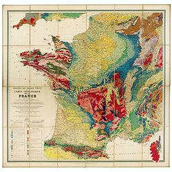
Carte géologique de la France.
Early geological map of France, published by Charles Béranger. Full title: " Ministère des Travaux publics, Carte géologique de la France 1:1'000'000, Exécutée ...
- $1200 / ≈ €1123
Place & Date: Paris, 1905

Excelsiori (Rana N. 28 - Cent. 20).
"After so many wars and so many troubles, young Russia, in a more serene glaze all the beautiful sun of freedom you will enjoy ... ". Fascinating allegorical sa...
Place & Date: Bologna, 1905

Atlas Geographique. (Puzzle).
Three map puzzles, each measuring 25 x 33 cm., housed in the original color printed card case. Geographical jigsaw puzzle set comprising three maps (world, Europe and Fra...
Place & Date: Paris, ca. 1910
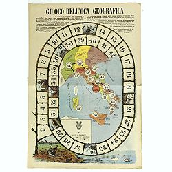
Giuoco Dell'Oca Geografica.
An attractive and rare playing board for a “Goose game” designed to teach the geographical places of Italy.The Game of the Goose is a race game wherein players move t...
Place & Date: Italy, ca. 1910
Selling price: $160
Sold in 2018
(Design for Hark ! Hark ! The dogs do bark.)
This very rare political caricature map of Europe depicts the continent at the outbreak of World War I, or as it was called at the time the Great War. The principal count...
- $3000 / ≈ €2807
Place & Date: London, ca. 1914

Hark ! Hark ! The dogs do bark.
This very rare political caricature map of Europe depicts the continent at the outbreak of World War I, or as it was called at the time the Great War. Designed by Johnson...
Place & Date: London, Johnson Riddle & Co., 1914

Mappa Humoristico da Europa.
A really unusual and lovely map, published in Portugal at the outbreak of The Great War in 1914. This outbreak of war in Europe was the result of a complex sequence of ev...
Place & Date: Lisbon, 1914

Karte von Europa im Jahre 1870 nach einem französischen Holzschnitte.
Satirical illustration by Paul Hadol showing disposition of power in Europe at the beginning of 1870. Satirical print depicting a map of Europe in which the countries are...
Place & Date: Hamburg, Fuchs, 1914
![[Goose game board] Le 1914 Edition pochette.](/uploads/cache/47214-250x250.jpg)
[Goose game board] Le 1914 Edition pochette.
Goose game in the form of a folding map of north of France and Belgium, with part of England, Germany, Holland and Luxembourg.More about board games [+]
- $450 / ≈ €421
Place & Date: Paris, 1914
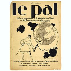
Le Pal - Nous ne connaissons ni la discipline des partis ni les complaisances de la camaraderie.
Original cover design in pen and ink by Henri Desbarbieux for the satirical bi-monthly journal Le Pal.Not much information is found about Henri Desbarbieux. In this BNF l...
- $300 / ≈ €281
Place & Date: Paris, 1925
![Hoo Daihiko Kinen Hiko Sugoroku [ [訪欧大飛行記念飛行双六 ]](/uploads/cache/46569-250x250.jpg)
Hoo Daihiko Kinen Hiko Sugoroku [ [訪欧大飛行記念飛行双六 ]
FIRST EDITION. A rare paper board game celebrating a flight from Tokyo to Rome Europe. Published in by Osaka Asahi Shinbun.This color offset-printed sugoroku (a paper “...
- $600 / ≈ €561
Place & Date: Osaka, Taisho 14 or 1925
![[Magazine including pictorial world map, Carriers of the New Black Plague by William Cotton.]](/uploads/cache/43680-250x250.jpg)
[Magazine including pictorial world map, Carriers of the New Black Plague by William Cotton.]
Front cover with color illustration of Moroccan male sheik and yellow lettering.Oversized magazine, features analysis of English justice, map of Herr Hitler's heaven (ful...
Place & Date: Chicago, April 7th, Vol.1 No.1 1938

Carriers of the New Black Plague.
A powerful satirical commentary on totalitarian control of speech from the first issue of Ken Magazine. "Caught here in all their peculiar beauty by the soul searchi...
Place & Date: Chicago, 1938

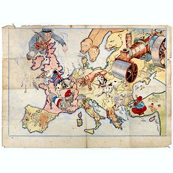
L'Europe en Sept 1939. Ille terrarum mihi angulus ridet.
A rare oversized serio-comic map of Europe at the start of the Second World War depicting stereotypes of 31 countries, as listed in the key lower right, including Brit...
Place & Date: Bruges, Leon Burghgraeve, 1939
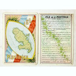
Isla Martinica.
A beautiful hand colored, hand drawn map of the French Caribbean island of Martinique, prepared for the Buenos Aires 1939 Philatelic Exhibition, with separate text with d...
- $100 / ≈ €94
Place & Date: Buenos Aires, 1939
![[Escape map] N°34 Southeast Asia + Northeast Asia.](/uploads/cache/40293-250x250.jpg)
[Escape map] N°34 Southeast Asia + Northeast Asia.
A fine "survival map" or "escape map" of China was compiled for the U.S. Army Air Forces. South China side has an inset of Taiwan (Formosa). These lig...
- $125 / ≈ €117
Place & Date: Washington, D.C. 1944
![[No title] Gouache of a class scene with globe, revolting students and a teacher.](/uploads/cache/44404-250x250.jpg)
[No title] Gouache of a class scene with globe, revolting students and a teacher.
Gouache of a class scene with a globe centered on Europe and Africa with revolting students and a teacher. Original design for a pulp publication.
- $350 / ≈ €328
Place & Date: ca. 1950-1960