
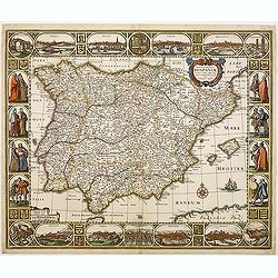
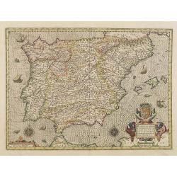
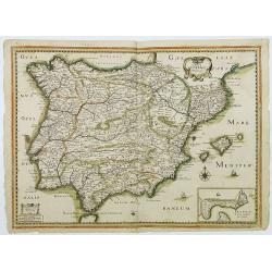
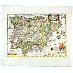
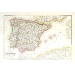
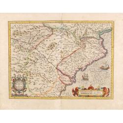
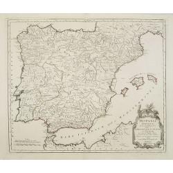
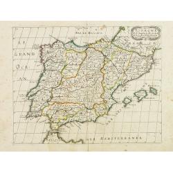
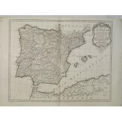
Nova et accurata Tabula Hispaniae. . .
Second state. The map shows the geographical image introduced by Hessel Gerritsz's 1612 wall map of Spain, based on information provided by the Coimbra University profess...
Place & Date: Amsterdam, 1633

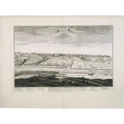
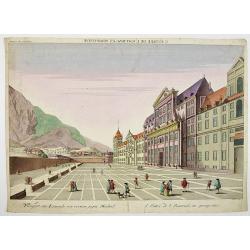
Madrid.
Extremely rare town-view of Madrid. Engraved by Francesco Ambrosi.With a second title in lower part "Madrid Ciudad Capital Del Reyno D'Espana y real corte de los rey...
Place & Date: Bassano del Grappa, c.1780

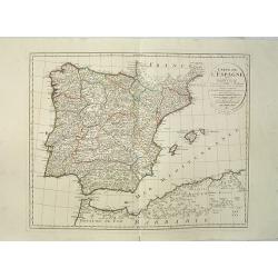
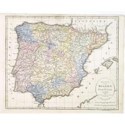
Tabula Secunda Europe (Spain & Portugal)
Wood block printed large-format Ptolemaic map of the Iberian Peninsula from the 1513 edition of Waldseemüller's Geographia.This Ptolemaic map comes from the first so cal...
Place & Date: Strasburg, 1513
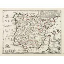
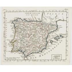
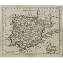
Nova et accurata Tabula Hispaniae. . .
Second state. This "carte à figures"- map of Spain and Portugal shows the geographical image introduced by Hessel Gerritsz's 1612 wall map of Spain. The map is...
Place & Date: Amsterdam, 1633
Madrid Villa Capital Del Reyno D'Espana.. / Madrid ville capitale du Royaume d'Espagne . . .
A very decorative and scarce town view of Madrid, including a numbered key ( 1-17 ) in Spanish and French in the lower part. Published by Jacques Chéreau, (1688 - 1776)....
- $3000 / ≈ €2807
Place & Date: Paris, ca.1750
![[Spain and Portugal]](/uploads/cache/47718-250x250.jpg)
[Spain and Portugal]
A rare map of Spain and Portugal engraved by Jan and Lucas van Deutecom and published by Gerard de Jode, Antwerp 1593. Latin text on verso.The map appeared in the second ...
Place & Date: Antwerp, 1593
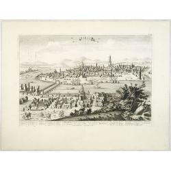
Seville. Ville Archiepiscopale et Capitale du Raume d'Andalousie en Espagne. . .
A very decorative and extremely rare view of Seville, including a numbered (1-37) key in the lower part. Published by Jacques Chéreau, (1688 - 1776). Engraved by Aveline...
- $2000 / ≈ €1871
Place & Date: Paris, ca.1750
Barcelone, Ville Capitale de la principauté Catalogne. . .
A very decorative and scarce view of Barcelona, including a numbered key ( 1-29 ) in the lower part. Published by Jacques Chéreau, (1688 - 1776). Engraved by Aveline and...
- $2000 / ≈ €1871
Place & Date: Paris, ca.1750

De Haven en Straat von Gibraltar, Niewlyks getekend, en in`t licht gebracht door Johannes Covens en Cornelis Mortier tot Amsterdam.
Decorative map showing the siege of Gibraltar during the Spanish war of succession. This highly interesting map is richly ornated with three additional inset maps and vie...
Place & Date: Amsterdam, 1710
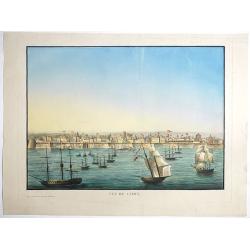
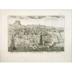
Vue de Cadix.
Very rare view of Cadiz and its seafront drawn and engraved by Renouard, published in Paris by Fatout et Avice, Quai Malaquais, 9. Beautifully hand colored at the time of...
- $1500 / ≈ €1404
Place & Date: Paris, Fatout et Avice, Quai Malaquais 9 , c.1838

Paskaert vande Bocht van Vranckrijck Biscajen. . .
An eye-catching chart of the coast of Bretagne from Brest running south till the coast of Biscay in Northern Spain.Including the towns of Ferrol in the west, Gijon, Santa...
Place & Date: Amsterdam, after 1666
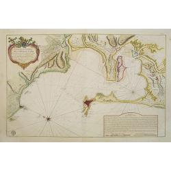
Carte Hydrographique De La Baye De Cadix. . .
Beautiful chart of the Bay of Cadiz, from Rota to Cadiz, with dramatic coastal topography, soundings, anchorages, forts, loxodromic lines, compass rose and large decorati...
- $1000 / ≈ €936
Place & Date: Paris, 1762
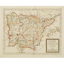
Parte Orientale della Spagna. . .
A scarce and very attractive double sheet detailed map of Spain and Portugal. This map appeared in the "Atlante Veneto", Coronelli's best known work. In a typic...
Place & Date: Venice, 1696

Paskaerte Vande Bocht van Vranckrijk Biscajen en Galissen
An eye-catching chart of Spain and France, including a large part of Brittany, including Isle de Reé , Isle Saint Martin ...Shows the gulf of the northeast Atlantic Ocea...
Place & Date: Amsterdam, 1669-1676
Pas-Caart van Hispangien vertoonde de Custen van Granade…
An eye-catching chart of Spain and Portugal, including a large part of Brittany and the southwestern coast of France, including Isle de Reé , Isle Saint Martin ...Pieter...
Place & Date: Amsterdam, 1669-1676
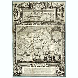
Plan de la ville de Roses avec les attaques.
Very rare and beautiful plan engraved by Pierre Lepautre, of the city of Roses in Catalonia, and celebrating the victory and capture of the city by Louis XIV in June 1693...
- $1500 / ≈ €1404
Place & Date: Paris, 1700
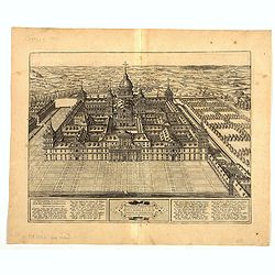
Scenographia Totius Fabricae S. Lau Renti Escoriali.
A wonderful west-looking bird's-eye view of the elaborate 16th century royal palace of San Lorenzo de El Escorial, a vast and elaborate complex commissioned by Philip II ...
Place & Date: Cologne, 1617
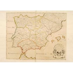
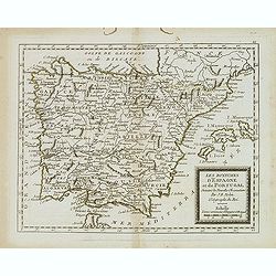
Hispaniae nova describtio. . .
Map of Spain and Portugal. Engraved by Petrus Kaerius.
- $750 / ≈ €702
Place & Date: Amsterdam, 1628
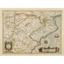
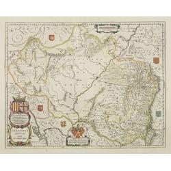
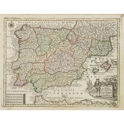
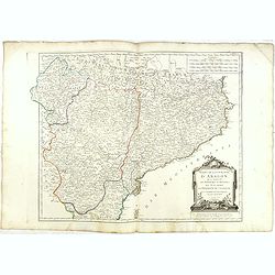
Arragonia et Catalonia
Aragon and Catalonia. Decorative map with mountain relief and river. 2 finely engraved sailing boats.Mercator was born in Rupelmonde in Flanders and studied in Louvain un...
- $600 / ≈ €561
Place & Date: Amsterdam, 1628

La pericolante ostinata. Papagallo No. 20 Anno II.
Design by Augusto Grossi. Taken from the Italian satirical newspaper Il Papagallo, a satirical magazine founded in January 1873 by Augusto Grossi (1835-1919), which speci...
Place & Date: Bologne, 1874
Carte generale d'Hespagne.
Rare map of Spain and Portugal from "Theatre des Gaules". In lower right corner a little inset of Cadiz.Very rare in original color.
- $750 / ≈ €702
Place & Date: Paris, 1637
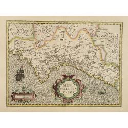
Regni Valentiae Typus.
Fine early map of Valencia.
- $500 / ≈ €468
Place & Date: Amsterdam, 1628
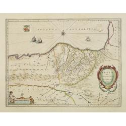
Biscaia et Guipuscoa Cantabriae veteris Pars.
Shows cities of Bilbao and Laredo, and includes a charming vignette of a putti with surveying equipment, being observed by a kitten. With Dutch text on verso.More about m...
Place & Date: Amsterdam, 1645
Seville ville Archiepiscopale et capitale du Royaume d'Andalousie en Espagne. . .
A very decorative and extremely rare town-view of Seville, including a numbered key ( 1- 37) in lower part. Engraved by Pierre-Alexandre Aveline. With "fait par Avel...
- $500 / ≈ €468
Place & Date: Paris, ca.1692
Typus Hispaniae ab Hesselo Gerardo delineata. . .
Decorative map of the kingdom of Spain and Portugal by Joan. Janssonius after the cartographic source by Hessel Gerard. Embellished by sailing ship, compass roses, and co...
- $550 / ≈ €515
Place & Date: Amsterdam, 1638
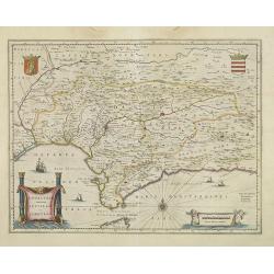
Andalusia continens Sevillam et Cordubam.
Features the province of Andalusia and the city of Seville, but also depicts the Straights of Gibraltar, know in classical times as the Pillars of Hercules. The title car...
Place & Date: Amsterdam, 1645
Circoscrizione delle province ecclesiastiche e Diocesinei regni di Spagna e Portogallo (Tav XLVI)
A large-format map of Spain and Portugal with its dioceses. The map is finely engraved and beautifully colored and was prepared by Girolamo Petri, a lawyer who served as ...
- $450 / ≈ €421
Place & Date: Rome, 1858
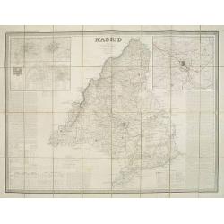
Madrid por el Teniente Coronel, Capítan de Ingenieros D. Francisco Coello. Las notas estadisticas é historicas han sido escritas por D. Pascual Madoz. Madrid 1853.
Second edition of this important and very detailed map of the region of Madrid prepared by Francisco Coello (1822 - 1898) and improved by Pascual Madoz (1806 - 1870). Eng...
- $400 / ≈ €374
Place & Date: Madrid, 1853
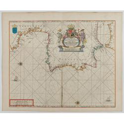
Andaluzia continens Sevillam.
Features the province of Andalucia and the city of Seville, but also depicts the Straights of Gibraltar, know in classical times as the Pillars of Hercules. Córdoba, Má...
- $550 / ≈ €515
Place & Date: Amsterdam, 1644
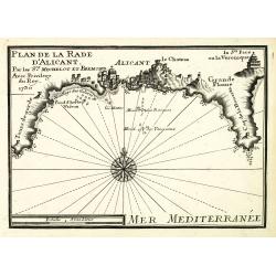
Plan de la Rade d'Alicant.
An attractive chart centered Alicante in Valencia along the Mediterranean. With scale and large compass-rose. Dated 1730, with the privilege of the King. From : Recueil d...
- $350 / ≈ €328
Place & Date: Marseille, 1730
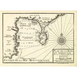
Plan de la Baye de Gibraltar.
An attractive chart centered on Gibraltar. With scale and large compass-rose. Dated 1727, with the privilege of the King. From : Recueil des Plusieurs plans des ports et ...
- $375 / ≈ €351
Place & Date: Marseille, 1730
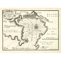
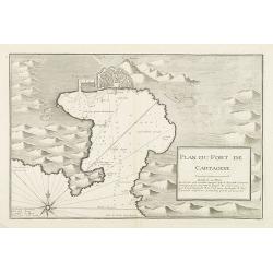
Plan du Port de Cartagène.
An attractive chart centered on the Bay of Cartagena. With scale and large compass-rose. Dated 1727, with the privilege of the King. From : Recueil des Plusieurs plans de...
- $375 / ≈ €351
Place & Date: Marseille, 1730
Carte géographique, physique et politique des royaumes d'Espagne et de Portugal indiquant les chemin fer en exploitations, ceux en cours d'éxécutions
Very large, highly detailed and uncommon map of Spain, Portugal and the northern coast of Africa. The map shows according to the title: rail roads, main interregional rou...
Place & Date: Paris, c.1867
![Sevilla, Hispalis ... [on sheet with] Cadiz [and] Malaga.](/uploads/cache/33642-250x250.jpg)
Sevilla, Hispalis ... [on sheet with] Cadiz [and] Malaga.
Very desirable and early view of Sevilla, Cadiz and Malaga, with the Roman and Moorish citadels on the hills in the background. "In the upper part Sevilla, showing ...
- $500 / ≈ €468
Place & Date: Cologne, (1572) 1577
Arragonia Regnum.
A beautiful, highly decorative map of Aragon, centered on Saragossa and extending to Balbasdtor, Huesca, Calataiud, Tortosa, Tervel, Albarrazin and Cuenca. Towns, rivers,...
Place & Date: Amsterdam, 1645
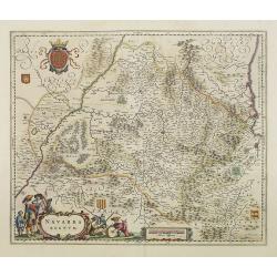
Navarra Regnum.
Decorative map of the region which includes the city of Pamplona at the centre of the map, Bayonne and San Sebastian. Highly decorative figured cartouche bottom left. Fou...
Place & Date: Amsterdam, 1645
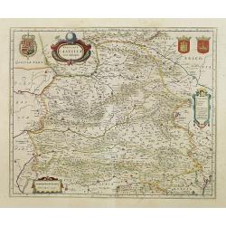
Utriusque Castillae nova descriptio.
Blaeu's map of León-Castilla, showing Zaragoza, Valencia, Alicante, Cartagena, Madrid, Cordoba, Seville, Salamanca, Palencia, Segovia, Toledo, Cuenca, Granada, etc. Incl...
Place & Date: Amsterdam, 1645
Legionis Regnum et Asturiarum Principatus.
A very decorative map by Willem Blaeu of the Spanish Province Asturias, Castile and Léon, including the towns of Oviedo, Leon, Santander, Valladolid, etc. With two fine ...
Place & Date: Amsterdam, 1645
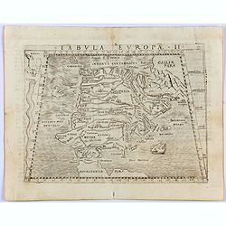
Tabula Europae II. (Spain and Portugal)
Gastaldi's map showing Spain and Portugal, based upon Ptolemy.It is one of the earliest obtainable maps of the region.From Giacomo Gastaldi's Atlas of 1548 which has been...
- $375 / ≈ €351
Place & Date: Venice, 1548
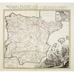
Hispania Benedictina, seu Monasteria et alia pia loca Ord. S. Benedicti ..
Map of the Iberian Peninsula and an inset map of South America with all the monasteries and holy places of the Benedictine order, compiled by the Benedictine friar Rupert...
Place & Date: Nuremberg 1750
![L'Espagne subdivisée en tous ses royaumes, princip[au]tés, seign[eu]ries. . .](/uploads/cache/33236-250x250.jpg)
L'Espagne subdivisée en tous ses royaumes, princip[au]tés, seign[eu]ries. . .
Map of Spain, Portugal, Majorca and Minorca with original outline hand-color. Numerous place-names of counties, cities, towns, physical features.
- $400 / ≈ €374
Place & Date: Paris, 1663
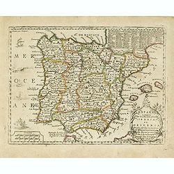
Arragonia et Catalonia.
Aragon and Catalonia. Decorative map with mountain relief and river. 2 finely engraved sailing boats.Mercator was born in Rupelmonde in Flanders and studied in Louvain un...
- $250 / ≈ €234
Place & Date: Amsterdam, 1628
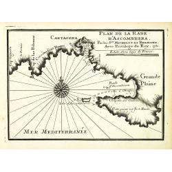
Plan de la Rade d'Ascombrera. . .
An attractive chart centered on Cartagena in Spain. With scale and large compass-rose. Dated 1730, with the privilege of the King. From : Recueil des Plusieurs plans des ...
- $300 / ≈ €281
Place & Date: Marseille, 1730
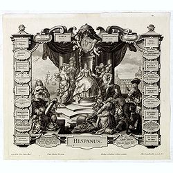
Hispanus.
Allegorical print of Spain (Hispanus), copper engraving after P. Decker by M. Engelbrecht. Taken from "Laconicum Europae Speculum". Philippe Andrea Kilian (1714...
Place & Date: Augsburg, 1737
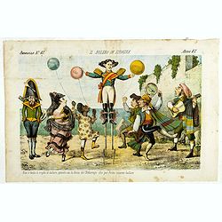
Il bolero in Ispagnia. Papagallo No. 42. Anno VI.
About Spanish expansion, with balloons symbolizing Cuba, Havana, Cortes. Taken from the Italian satirical newspaper Il Papagallo, a satirical magazine founded in January ...
Place & Date: Bologne, 1878
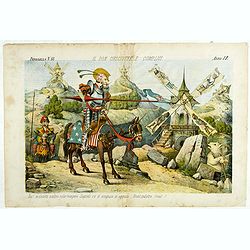
Il Don Cihsciotte a complici. Papagallo No. 48. Anno VI.
Taken from the Italian satirical newspaper Il Papagallo, a satirical magazine founded in January 1873 by Augusto Grossi (1835-1919), which specialized in color-printed ca...
Place & Date: Bologne, 1878
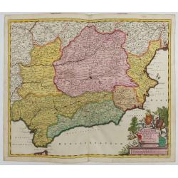
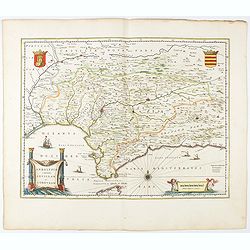
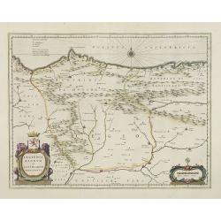
Regnorum Castellae, Novae, Andalujsae, Granadae, Valentae, et Murciae Accurata Tabula
Decorative map of Southern Spain, extending from Salamanca and Segovia in the North, to the Gulfs of Valentia, Alicante and Cartagena in the east, the Straits of Gibralta...
Place & Date: Amsterdam, 1645-1680
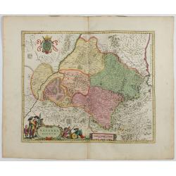
Navarra Regnum.
RARE : The signature by Willem Blaeu in the lower right corner has been erased. The copperplate was published by Frederick de WitDecorative map of the region which includ...
Place & Date: Amsterdam, 1645-1680
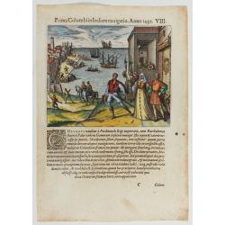
Prima Columbiin Indiam navigation Anno 1492.
Christopher Columbus and the Pinzon brothers leaving the port of Palos in Spain on August 3, 1492 for the New World. Right The King and Queen of Portugal Catholic Ferdina...
- $400 / ≈ €374
Place & Date: Frankfurt, 1594

Cazal. (Casale Monferrato)
A rare panoramic of Casale Monferrato in the Piedmont region. Engraved by Pierre Aveline (Paris, c.1656 - 23 May 1722). He was also a print-publisher and print-seller. H...
Place & Date: Paris, 1690-1730
Hispaniae Antiquae Tabula.
A fine map of ancient Spain, Portugal and Majorca, etc.This edition carries the date 1641 and in manuscript pencil 1690.Nicolas Sanson was to bring about the rise of Fren...
- $200 / ≈ €187
Place & Date: Paris, 1641-1690
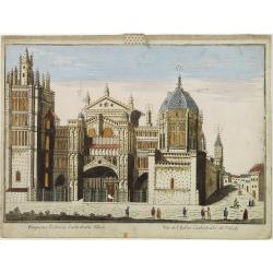
Vüe de L'Eglise Cathedrale de Tolede.
A so-optical print of a church in Toledo, Spain, prepared for use in a light-box or an amusing light-show. This richly hand colored print is much perforated, windows are ...
Place & Date: Italy ca 1780
Hispania Antiqua in tres praecipuas partes..
Map of the Hibernia peninsula and the Balearic Islands. With a rococo title cartouche in the lower right corner.Venetian edition of Giles Didier Robert De Vaugondy's map ...
Place & Date: Venice, 1776 - 1784
Carte de l'Espagne Dressée par Guillaume Delisle sur la description de Rodrigo Mendez Sylva . . .. Le tout augmenté et vérifié en 1789. Par Phil. Buache, de l'Académie des Sciences.
Map of Spain and Portugal, including the North African coast and good detail for Majorca, Minorca and Ibiza. Published by Dezauche at his address Rue de Sorbonne, n°9, a...
- $200 / ≈ €187
Place & Date: Paris, 1827
L'Espagne nominée Par les Anciens Grecs Iberia ou Hesperia..
Lovely small map of Spain with decorative title cartouche, vessels and a sea monster in the Atlantic Ocean.Presenting a panel in the upper right corner listing local rule...
Place & Date: Paris, 1719
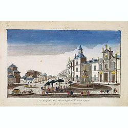
Vue perspective de la prison royale de Madrid en Espagne . . .
So-called optical print of the Royal Prison, now the Ministry of Foreign Affairs in Madrid. Published by Jacques Chereau, who was a well-known publisher of optical prints...
- $200 / ≈ €187
Place & Date: Paris, ca. 1750
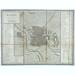
Madrid.
Plan of Madrid, by Tardieu. With numbered key (1-74) of the main buildings and buildings of the city. Table with translations of Spanish words in the right bottom.
- $150 / ≈ €140
Place & Date: Paris?, ca. 1790
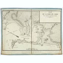
Plan de la baie de Cadiz pour servir aux opérations de 1823.
Detailed map of the bay of Cadiz, drawn up during the battle of the Fort of Trocadero on August 31, 1823, which consecrated the victory of a French expeditionary force ov...
- $175 / ≈ €164
Place & Date: Paris, ca. 1823
Les Royaumes d'Espagne et de Portugal, divisés Par Grandes Provinces..
Attractive map of the Iberian Peninsula. Ornated with a decorative title cartouche showing the coats of arms of Spain and Portugal.Prepared by Le Sieur Janvier, Jean deni...
- $200 / ≈ €187
Place & Date: Venice, 1776 - 1784
Plan du Port de Cartagene.
Sea chart of the Port of Cartagene. Marked with navigational notes.From the rare chart book by Jacques Ayrouard: Recueil de plusieurs Ports de la Mer Méditerranée...
- $200 / ≈ €187
Place & Date: Marseille, 1732-1746
Prospect des Escurials von vornen gegen Madrid / L'entrée de l'Escurial, en perspective.
A so-called optical print of the the entrance to the Escurial at the foot of the Sierra Guadarrama in Spain. Bilingual title in German and French. Engraved by Leizel.
- $150 / ≈ €140
Place & Date: Augsburg, 1780

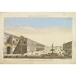
A view of the palace plaisans of Reyn Hongres...
So-called optical print of Aranjuez Palace near Madrid, and wrongly described as situated near to Vienna. Publishedby Huquier, a well-known publisher of optical prints, e...
- $125 / ≈ €117
Place & Date: Paris, 1760
Vue perspective de la Grande Place de St.Francois a Seville.
So-called optical print. Daumont was a well-known publisher of optical prints, established in Paris. In the eighteenth and nineteenth centuries there were many popular sp...
Place & Date: Paris, 1760
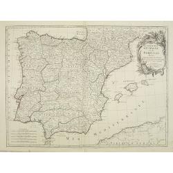
Espagne.
Rare map of Spain and Portugal, published by Jollain in 1667. Published in "Trésor Des Cartes Geographiques Des Principaux Estats de Lunivers".This atlas is ba...
- $200 / ≈ €187
Place & Date: Paris, 1667
Espagne. . .
Map of Spain and Portugal prepared by N.Sanson and published by Pierre Mariette.Published in an early edition of the small Sanson atlas L'Europe Dediée a Monseigneur . ....
Place & Date: Paris, P. Mariette, 1667
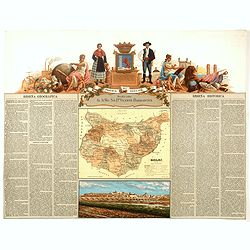
Provincia de Caceres.
Chromolithography published in "Atlas geográfico histórico de las Provincias de España". Map made by M. Vierge, Dedicated to Excmo. Sr. Dn. Cipriano Segundo ...
- $120 / ≈ €112
Place & Date: Madrid, c. 1875
Provincia de Badajoz.
Chromolithography published in "Atlas geográfico histórico de las Provincias de España". Map engraved by M. Vierge, Dedicated to Ilmo. Sr. Dn. Vicente Barran...
- $120 / ≈ €112
Place & Date: Madrid, c. 1875
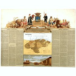
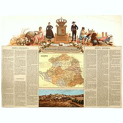
Provincia de Santander.
Chromolithography published in "Atlas geográfico histórico de las Provincias de España". Map engraved by J. Reinoso, Dedicated to Excmo. Sr. Duque de Santona...
- $120 / ≈ €112
Place & Date: Madrid, c. 1875
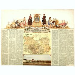
Provincia de Ciudad-Real.
Chromolithography published in "Atlas geográfico histórico de las Provincias de España". Map made by J. Reinoso, Dedicated to Excmo. Sr. Dn. Baldomero Espart...
- $120 / ≈ €112
Place & Date: Madrid, c. 1875
Les royaumes d'Espagne et de Portugal. . .
Scarce map of Spain and Portugal prepared by Nolin and published by L.J. Mondhare for his Atlas Général a l'usage des colleges et maisons d'education.. Louis Joseph Mon...
- $100 / ≈ €94
Place & Date: Paris, 1783
Novillinta et accura tilsnia Regnorum Hispaniae et Portugalliae. . .
Miniature map of Spain and Portugal, a reduction of the Seutter''s folio map.From Atlas Minor, here published by Johann Martin Will, with his address in bottom center of ...
- $200 / ≈ €187
Place & Date: Augsburg, J.M.Will, 1778
L'Espagne nominée Par les Anciens Grecs Iberia ou Hesperia. . .
Lovely small map of Spain with decorative title cartouche, vessels and a sea monster in the Atlantic Ocean.Presenting a panel in the upper right corner listing local rule...
- $150 / ≈ €140
Place & Date: Paris, 1719
Carte de l'Espagne Dressée par Guillaume Delisle sur la description de Rodrigo Mendez Sylva . . .. Le tout augmenté et vérifié en 1789. Par Phil. Buache, de l'Académie des Sciences.
Map of Spain published at the outbreak of the French Revolution. Taken from the Atlas Géographique.. published by Dezauche, as successors to De l'Isle & Buache. Publ...
- $150 / ≈ €140
Place & Date: Paris, 1789
Karta öfver Spanien och Portugal.
An very rare map of Spain and Portugal with Swedish text. This is an updated version of his map of 1819 and is now dated 1833.From his atlas "Geographisk Hand-Atlas&...
- $100 / ≈ €94
Place & Date: A. Wiborgs förlag, Stockholm, ca. 1848
S. Laurens in Escurial.
A very nice picture representing the monastery of San Lorenzo del Escorial. On the foreground the god Jano, with two faces. With a verse in two languages underneath the p...
- $90 / ≈ €84
Place & Date: Frankfurt 1623-1678
Les Royaumes d'Espagne et de Portugal ..
Rare map of Spain and Portugal prepared by J.B.Nolin and published by Monhare for his Atlas Général a l'usage des colleges et maisons d'education.. Louis Joseph Mondhar...
- $120 / ≈ €112
Place & Date: Paris, 1783
L'Espagne et le Portugal. Divisés Par Gdes. Provinces.
Map of Spain and Portugal, including the Balearic Islands archipelago. From Atlas de la Géographie de toutes les parties du monde .. Ouvrage destiné pour l'education, e...
- $80 / ≈ €75
Place & Date: Paris, Prudhomme, Levrault, Debray, 1806
Etats de la Couronne d'Aragon...
Detailed map of the eastern part of Spain. Numerous place-names of counties, cities, towns, physical features.Prepared by "Robert de Vaugondy fils," to whom San...
- $150 / ≈ €140
Place & Date: Venice, 1776 - 1784
L' Espagne et le Portugal . . .
Map of Spain and Portugal, from Atlas moderne portatif composé de vingt-huit cartes sur toutes les parties du globe terrestre .. A l'usage des Colléges, des Pensions &a...
Place & Date: Paris, Prudhomme, Levrault, Debray, 1806
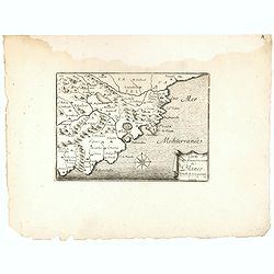
Carte du Gouvernement de Blanes.
Decorative print of the area around Blanes, in Catalonia. Engraved by Pérelle. Embellished with a compass rose.
- $80 / ≈ €75
Place & Date: Paris ca. 1660