Browse Listings
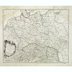
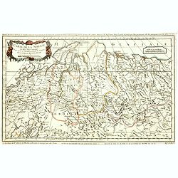
Germania Antiqua. . .
A fine map of ancient Germany, Poland and the Netherlands from his "Atlas Universel".Gilles Robert de Vaugondy (1688–1766), also known as Le Sieur or Monsieur...
- $50 / ≈ €47
Place & Date: Paris, 1756

INTERIEUR DE LA CATHEDRALE A CHARTRES. Dessiné d'après nature par Chapuy. Lith. Par Bachelier.
Original lithograph of the inside of the cathedral situated in Chartres. Lithographed by Bachelier after a design by Chapuy and printed in Paris by Lemercier, Bernard Cie...
- $35 / ≈ €33
Place & Date: Paris, 1844
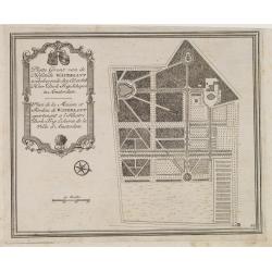
Platte Gront van de Hofstede Waterlant toebehorende den Ed. Achtb. Heer Dirk Trip Schepen te Amsterdam.
Uncommon plan of Hofstede Waterlant. Published in Hollandsche Arcadia. Title in Dutch and French "Plan de la Maison et Jardins appartenant a l'Illustre Dirk Trip Ech...
- $40 / ≈ €37
Place & Date: Amsterdam, 1740
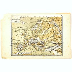
Oro-Hydrographische Kaart van Europa.
One of the earliest thematic maps of Europe published in the Netherlands from "Atlas der natuurkundige aardrijkskunde. . .". prepared by Nicolaas Wilhelmus Post...
- $35 / ≈ €33
Place & Date: Amsterdam, C.L. Brinkman, 1883

Oro-Hydrographische Kaart van Azië.
One of the earliest thematic maps of Asia published in the Netherlands from "Atlas der natuurkundige aardrijkskunde. . .". prepared by Nicolaas Wilhelmus Posthu...
- $35 / ≈ €33
Place & Date: Amsterdam, C.L. Brinkman, 1883
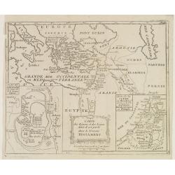
Carte des Régions et des Lieux dont il est parlé dans le Nouveau Testament.
Map of the eastern part of the Mediterranean with its hinterland. In the lower corners two inset maps: a plan of Jerusalem in the lower left, a map of Judea or Palestine ...
Place & Date: Paris, Prudhomme, Levrault, Debray, 1806
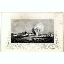
Bombardment of Odessa by the English and French April 22 1854, explosion on the imperial mole . . .
Scene from the Crimea war, showing a bombardment of Odessa, 22nd April 1854 (during Crimean War, 1853-56), by English and French forces, explosion imperial mole (breakwat...
- $30 / ≈ €28
Place & Date: London, 1855
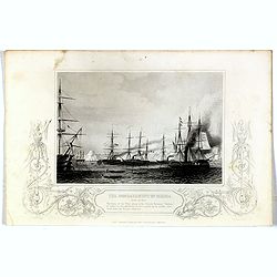
Bombardment of Odessa by the English and French April 22 1854, The boats of the British Fleet going to the French steamer 'Vauban' . . .
Scene from the Crimea war, showing the bombardment of Odessa, 22nd April 1854 (during Crimean War, 1853-56), engraving by G. Greatbach after drawing by H.W. Nicholls, c. ...
- $30 / ≈ €28
Place & Date: London, 1855
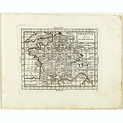
Francia divisa in provincie.
Rare map of France, from "Atlante Novissimo ad uso Dei Giovani Studiosi Contenuto In Carte XXVII.", published by Giovanni Zempel in Rome, ca. 1780.The map is ba...
- $50 / ≈ €47
Place & Date: Rome, 1780
![France en general. [de l'Europe / Figure LXVII] 147](/uploads/cache/38437-250x250.jpg)
France en general. [de l'Europe / Figure LXVII] 147
A fine and uncommon early 17th century map of France.From the French text edition of "Description d'Univers", 1683. by Allain Manneson Mallet (1630-1706), a wel...
- $30 / ≈ €28
Place & Date: Paris, 1683
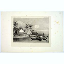
Village de Warrou.
Lithograph of the small settlement of Waru on the island of Seram in Indonesia. Plate 127, taken from the "Voyage au Pole Sud et dans L'Oceanie…." Departing i...
- $50 / ≈ €47
Place & Date: Paris, 1842
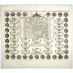
Carte Pour L'Intelligence De L'Histoire De Lorraine . . .
Map of Lorraine, surrounded by 34 portraits of the rulers of Lorraine and information concerning the present government structure of the Duchy. Surmounted by an elaborate...
- $50 / ≈ €47
Place & Date: Amsterdam, 1728
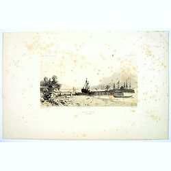
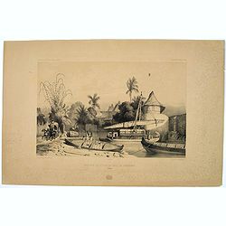
Rade d'Amboine.
A peaceful lithograph of ships and boats at anchor in Ambon Island, located in the archipelago of the Moluccas in Indonesia. Plate 108 taken from the 'Voyage au Pole et d...
- $35 / ≈ €33
Place & Date: Paris, 1842
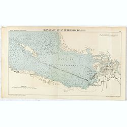
Cronstadt et St. Petersbourg.
Detailed plan of the port and city of St. Petersburg including Kotlin Island and the fortified town of Kronstadt.
- $35 / ≈ €33
Place & Date: Paris, 1888
![[assorted Chinese musical instruments].](/uploads/cache/37968-250x250.jpg)
[assorted Chinese musical instruments].
A delightful copperplate print of 15 assorted Chinese musical instruments including gong, bell, drum, cymbals etc.
- $35 / ≈ €33
Place & Date: Germany, ca. 1812
Arabesques. - Incrustations en stuc sur pierre.
Lithographed by Daumont. From the author's "L'Art Arabe d'après les monuments du Kaire…". Emile Prisse d'Avennes, Orientalist and Muslim convert, obsessive i...
- $30 / ≈ €28
Place & Date: Paris, 1877
![[assorted Chinese musical instruments].](/uploads/cache/37969-250x250.jpg)
[assorted Chinese musical instruments].
A delightful copperplate print of 15 assorted Chinese musical instruments including violin, flute, trumpet, guitars, cymbals etc.
- $30 / ≈ €28
Place & Date: Germany, ca. 1812
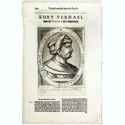
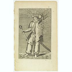
Selimus Primus Imperator Turcarum decimus Tertius.
The engraving depicts a half length oval portrait of Selim I, who was the Sultan of the Ottoman Empire from 1512 to 1520. His reign is notable for the enormous expansion ...
- $30 / ≈ €28
Place & Date: Amsterdam, Cloppenburch, 1621
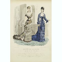
Paris fashion plate. (297)
From "Revue de la Mode - Gazette de la Famille". Underneath the print are the names of the shops where the clothing's, perfumes, porcelains, flowers, etc., depi...
- $40 / ≈ €37
Place & Date: Paris, dated 1877
Entrée de la Riviere de Paiou.
A lithograph showing the entrance to the river Paiou on Vanikoro Island, a part of the Santa Cruz Group and the Solomon Islands in the Pacific. Plate 97 taken from the 'V...
- $50 / ≈ €47
Place & Date: Paris, 1842
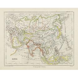
Azie.
Uncommon map of Asia. Lithography by J.H. van Weijer, published in Atlas der geheele Aarde [...] in 24 kaarten.
Place & Date: Groningen, ca. 1860
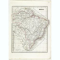
Brésil.
Detailed map of Brazil, prepared by Charles V. Monin (fl.1830-1880) a French cartographer of Caen and Paris. Published in Atlas Universel de Géographie Ancienne &c M...
- $45 / ≈ €42
Place & Date: Paris, 1845
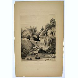
Aiguade d'Amboine.
Men with barrels in a river on the Indonesian island of Ambone. Plate112 taken from the 'Voyage au Pole et dans L'Oceanie…' Departing in late 1837 in the Astrolabe and ...
- $40 / ≈ €37
Place & Date: Paris, 1842
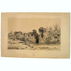
Site sur les bords du canal de Samarang.
A lithograph showing a Canalside scene of activity in the northeastern Javanese city of Semarang. Plate 149 taken from the 'Voyage au Pole et dans L'Oceanie…' Departing...
- $50 / ≈ €47
Place & Date: Paris, 1842
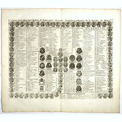
Carte genealogique des Rois de France avec l'Etat des Principaux Officiers de la Maison du Roy.
A genealogical tree of the French Kings with descriptive French text, from Chatelain's monumental 7 volume "Atlas Historique". Henri Abraham Chatelain (1684 –...
- $35 / ≈ €33
Place & Date: Amsterdam, 1728
Carte de la sibérie et des Pays voisins.
An interesting detailed map of Siberia, extending from the White Sea and the Caspian Sea in the west to Irkuckoi Province .Prepared by Jacques Nicolas Bellin after Dutch ...
- $50 / ≈ €47
Place & Date: Paris, 1738-1775
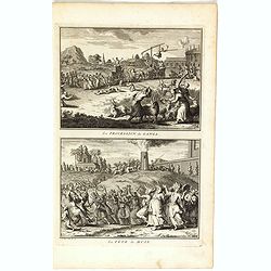
La procession de Ganga/ La fête de Huly.
Two scenes on one page showing religious scenes, in Japan. Fine copper engraving by Bernard Picart and taken from Bernard Picart's famous Céréonies et costumes religieu...
- $30 / ≈ €28
Place & Date: Amsterdam, 1743
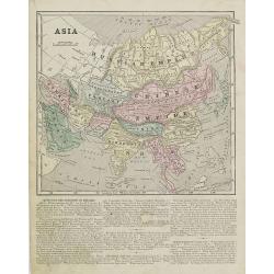
Asia.
Map of Asia encompassing the Russian Empire, the Chinese Empire, India Persia, Tartary, Turkey, and Arabia. From Sidney E. Morse''s: System of Geography for the use of sc...
Place & Date: New York, 1855
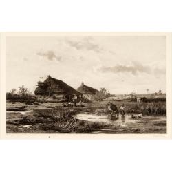
Dutch landscape.
Attractive lithography showing a typical Dutch landscape, lithographed by F.H.Weissenbruch after a painting by W.Roelofs. Published in Kunst Kroniek.
- $50 / ≈ €47
Place & Date: The Hague, 1865
![[De terra sancta.]](/uploads/cache/32540-250x250.jpg)
[De terra sancta.]
On verso a map of the Middle East with Syria, Israel and Cyprus (123x158mm.). From a Latin text edition of his Geographia , that great compendium of Renaissance knowledge...
- $50 / ≈ €47
Place & Date: Basle, 1550-1590
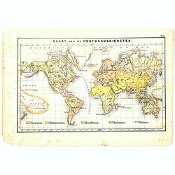
Kaart van de Hoofdgodsdiensten.
One of the earliest thematic world maps published in the Netherlands from "Atlas der natuurkundige aardrijkskunde. . .". prepared by Nicolaas Wilhelmus Posthumu...
- $35 / ≈ €33
Place & Date: Amsterdam, C.L. Brinkman, 1883
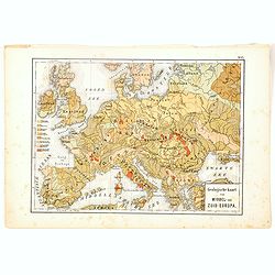
Geologische Kaart van Middel- en Zuid-Europa.
One of the earliest thematic maps published in the Netherlands from "Atlas der natuurkundige aardrijkskunde. . .". prepared by Nicolaas Wilhelmus Posthumus. Wit...
- $35 / ≈ €33
Place & Date: Amsterdam, C.L. Brinkman, 1883
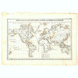
Kaart, voorstellende de Seculaire Rijzingen en Dalingen van den Bodem, alsmede de Vulkamen.
One of the earliest thematic world maps published in the Netherlands from "Atlas der natuurkundige aardrijkskunde. . .". prepared by Nicolaas Wilhelmus Posthumu...
- $35 / ≈ €33
Place & Date: Amsterdam, C.L. Brinkman, 1883
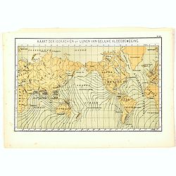
Kaart der Isorachiën of Lijnen van Gelijke Vloedbeweging.
One of the earliest thematic world maps published in the Netherlands from "Atlas der natuurkundige aardrijkskunde. . .". prepared by Nicolaas Wilhelmus Posthumu...
- $35 / ≈ €33
Place & Date: Amsterdam, C.L. Brinkman, 1883
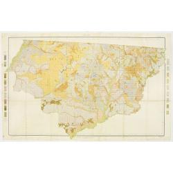
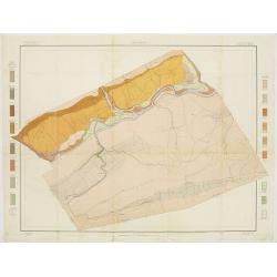
Soil map - Florida, Gadsden County sheet.
Early color lithographed soil map by Julius Bien & Co. in New York for the Department of Agriculture. Legends at the side give detail on soil type, etc. They also inc...
- $40 / ≈ €37
Place & Date: New York, 1903
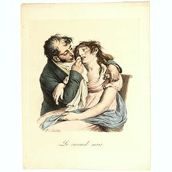
Le Second Mois. (The second month).
Lithograph depicting a woman suffering and her husband supporting her with the early pregnancy sicknesses.Belonging to the series "LES GRIMACES" by Louis-Léopo...
- $50 / ≈ €47
Place & Date: Paris, c. 1830-1900
![Westelijk Halfrond. [Western hemisphere]](/uploads/cache/25524-250x250.jpg)
Westelijk Halfrond. [Western hemisphere]
Uncommon world map view of the western and eastern hemispheres of North and South America, Asia. Lithography by J.H. van Weijer, published in Atlas der geheele Aarde [?] ...
- $50 / ≈ €47
Place & Date: Groningen, ca. 1860
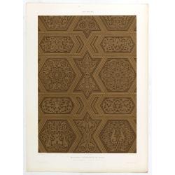
Art arabe. - Mosquée cathédrale de qous Détails du Mimbar. . .
Lithographed by Daumont. From the author's "L'Art Arabe d'après les monuments du Kaire…". Emile Prisse d'Avennes, Orientalist and Muslim convert, obsessive i...
- $50 / ≈ €47
Place & Date: Paris, 1877
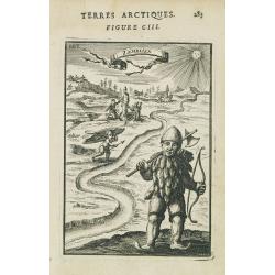
Zemblien.
Engraving presenting inhabitants of Nova Zembla from his monumental work "Description de L'Univers."
Place & Date: Paris, 1685
![Voyage au Pole Sud et dans l'Oceanie. . . [Planche 20].](/uploads/cache/14136-250x250.jpg)
Voyage au Pole Sud et dans l'Oceanie. . . [Planche 20].
"An attractive collection of shells. From Jules-Sébastien-César Dumont d'Urville (1790-1842) ""Voyage au Pole Sud et dans l'Océanie sur les Corvettes L'...
- $150 / ≈ €140
Place & Date: Paris, 1833
![[Ostiaks ].](/uploads/cache/25822-250x250.jpg)
[Ostiaks ].
Aquatint depicting a Ostiaks people engraved by D.K. Bonatti, after drawings by C. Bottigella.The Ostiak people are a tribe who inhabit the basin of the Ob in western Sib...
- $50 / ≈ €47
Place & Date: Milan, 1827
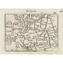
Noricum.
A miniature map showing a part of Bavaria, including the cities of Bamberg and Nuremberg. Title cartouche on the left side.First published in 1598 in his Caert-Thresoor, ...
- $50 / ≈ €47
Place & Date: Amsterdam / Frankfurt, 1609
![[IV.] Carte du Brabant où se trouvét la Mairie de Santhoven.. Ryen.](/uploads/cache/24684-250x250.jpg)
[IV.] Carte du Brabant où se trouvét la Mairie de Santhoven.. Ryen.
Nice small map encompassing an area which straddles the border between Belgium and the Netherlands.Showing Antwerp in the central lower part. From Atlas Portatif Universe...
Place & Date: Paris, later than 1748
Selling price: $70
Sold in 2008
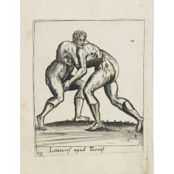
Lotatoref apud Turcaf (Turks wrestling)
Beautiful engraving of Turk's wrestling, copied after an illustration by Abraham de Bruijn, originally published in 1577 in Cologne.
Place & Date: c. 1600
![[Samoyedes ].](/uploads/cache/25823-250x250.jpg)
[Samoyedes ].
Aquatint depicting Samoyedes warming up around a camp fire engraved by D.K. Bonatti, after drawings by C. Bottigella. The Samoyedes is a tribe of the Ural-Altaic group, s...
- $50 / ≈ €47
Place & Date: Milan, 1827
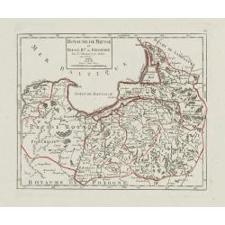
Royaume de Prusse et Prusse Rle. ou Polonoise.
On the left is Pomerania and the Desert of Waldow. At the top of the map is Memel and Samland. On the right side is the Biss River and Kautten. In the center of the map i...
- $125 / ≈ €117
Place & Date: Paris, later than 1749
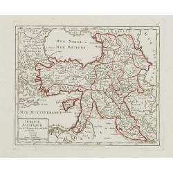
Turquie Asiatique..
Small detailed map of the Near East, including Cyprus, the Black Sea and Georgie. From Atlas Portatif Universel, by Robert de Vaugondy.Page 65 outside border top right. M...
- $100 / ≈ €94
Place & Date: Paris, later than 1748
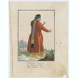
Femme de Tatares Nogais.
Uncommon copper engraved costume plate from the French translation of Johann Gottlieb Georgi "Beschreibung aller Nationen des Russischen Reichs" (1776), the wor...
Place & Date: St. Petersbourg, C.G. Müller, 1776-1777
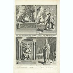
Charlatans qui se mêlent de vendre le vent de la Chine. Dévots mendiants de la Chine et charlatans qui se promènent sur des tigres apprivoisés, . . .
Two fascinating engraving on one sheet depicting Chinese charlatans. Engraved by Bernard Picart. Published in Jean Frederic Bernard's monumental "Cérémonies et cou...
- $150 / ≈ €140
Place & Date: Amsterdam, J.F. Bernard c.1736
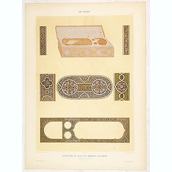
Art arabe. - Ecritoire du soultan Bahrite Schâban. . .
Lithographed by Daumont. From the author's "L'Art Arabe d'après les monuments du Kaire…". Emile Prisse d'Avennes, Orientalist and Muslim convert, obsessive i...
- $50 / ≈ €47
Place & Date: Paris, 1877
![[Yakuts ].](/uploads/cache/25825-250x250.jpg)
[Yakuts ].
Aquatint depicting Yakuts in traditional dress engraved by D.K. Bonatti, after drawings by C. Bottigella.The Yakuts live in the Republic of Sakha (YakutiaYakutia), Khabar...
- $75 / ≈ €70
Place & Date: Milan, 1827
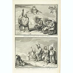
Idole que les chinois appellant, le dieu de l´immortalité, et qu´ils disent presider a leur Fortune. . .
Four fascinating engraving on one sheet depicting Chinese gods. "Idole que les chinois appellant, le dieu de l´immortalité, et qu´ils disent presider a leur Fortu...
- $150 / ≈ €140
Place & Date: Amsterdam, J.F. Bernard c.1736
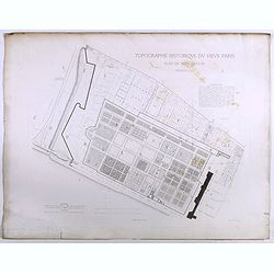
Topographie historique du vieux Paris / Plan de restitution Feuille V bis.
Copper engraved plan centered on gardens of the Louvre by Jean-Joseph Sulpis (1826–1911) after a model by Adolphe Berty. Plate 5bis from "Topographie historique du...
Place & Date: Paris, 1866-1897
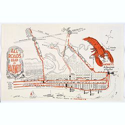
Map of Atlantic City to Hackney's Famous Garden of Sea Food . . .
A mid 1950s brochure for the famous Atlantic City Seafood Restaurant - 'Hackneys'. One side proclaims that "All Roads lead to Hackney's". It shows a nice plan o...
- $50 / ≈ €47
Place & Date: New Jersey, ca 1954
![S. Victor in Franckr. [France].](/uploads/cache/13770-250x250.jpg)
S. Victor in Franckr. [France].
A very nice view of the church. On the foreground, a night watchman is depicted. With a verse in two languages underneath the picture.The poet and topographer from Comoth...
- $40 / ≈ €37
Place & Date: Frankfurt, 1623-1678
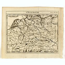
L'Allemagne.
Scarce small map of Germany, Poland and Low Countries based on cartography of Guillaume Delisle (. Published in "Nouveau traité de geographie par M**** ", publ...
- $50 / ≈ €47
Place & Date: Paris, 1752
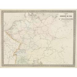
Carte des Chemins de Fer de l'Allemagne.
Fine map of Germany, The Netherlands and Eastern Europe, showing the early railway system of the area. From Atlas des Chemins de Fer published by Napoléon Chaix and pri...
Place & Date: Paris, 1863
Selling price: $2
Sold in 2011
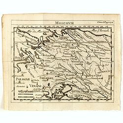
Moscovie.
Scarce small map centered on Muscovy and based on cartography of Guillaume Delisle (. Published in "Nouveau traité de geographie par M**** ", published by La v...
- $50 / ≈ €47
Place & Date: Paris, 1752
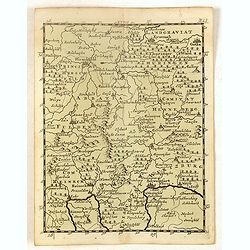
(Schweinfurt, Reineck, Hirschfeld, etc.)
Rare miniature map including the towns of Schweinfurt, Reineck, Hirschfeld, etc. From "Le theatre De Bellone, Contenant 48. nouvelles Cartes Geographiques, Des Païs...
- $60 / ≈ €56
Place & Date: Amsterdam, 1710
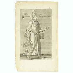
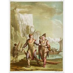
Delli de nation Parthique qui signifie Sol Harfy ou Enfant Perdu. (17)
Sought-after copper engraved plate taken from Laonikos Chalcocondyle’s "L'histoire de la décadence de l'empire grec et establissement de celuy des Turcs." by...
- $50 / ≈ €47
Place & Date: Paris, Mathieu Guillemot, 1650
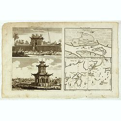
Chinese Temples. Sin-Ko-Tsyen. Canton, Sancian Isle. Ma-Kao.
An attractive print divided into four areas, two depicting Chinese temples and the other two with maps of the city of Canton, the island of Sancian and the island of Ma-K...
- $75 / ≈ €70
Place & Date: London, 1745-1747
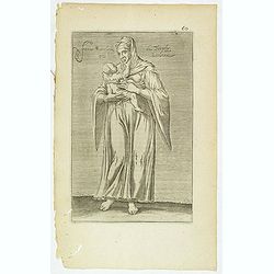
Femme de la Caramanie. (57)
Sought-after copper engraved plate taken from Laonikos Chalcocondyle’s "L'histoire de la décadence de l'empire grec et establissement de celuy des Turcs." by...
- $50 / ≈ €47
Place & Date: Paris, Mathieu Guillemot, 1650

Femme tatares de Tchatsk.
Uncommon copper engraved costume plate from the French translation of Johann Gottlieb Georgi "Beschreibung aller Nationen des Russischen Reichs" (1776), the wor...
Place & Date: St. Petersbourg, C.G. Müller, 1776-1777
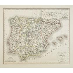
Espagne et Portugal . . .
Detailed map of Spain and Portugal, Majorca and Minorca, etc., prepared by A. H. Basset, rue Saint-Jacques, no. 64, Paris and published in Atlas Classique et Universel de...
- $100 / ≈ €94
Place & Date: Paris, A.H. Basset, 1828
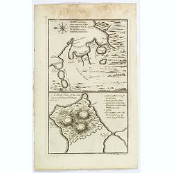
Charta exhibens Situm antiquum Carthaginis, Uticae. . . / A Bird's View of the Situation of Antient Carthage.
A pair of engravings of ancient Carthage in North Africa, from Charles Rollins' "The Ancient History of the Egyptians, Carthaginians, Assyrians, Babylonians, medes &...
- $50 / ≈ €47
Place & Date: London, ca 1768
Femme moresque de Tripoly en Barbarie. (60)
Sought-after copper engraved plate of a woman with child from Tripoli. Plate from Laonikos Chalcocondyle’s "L'histoire de la décadence de l'empire grec et establi...
- $45 / ≈ €42
Place & Date: Paris, Mathieu Guillemot, 1650
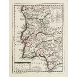
Les Royaumes de Portugal et d'Algarve..
Lovely small map of Portugal showing a panel in the upper right corner with a list of local rulers.From Le Nouveau et Curieux Atlas Geographique et Historique.. by Jacque...
Place & Date: Paris, 1719
Fille Moresque esclave en Alger ville de Barbarie. (63)
Sought-after copper engraved plate of a young slave from Algeria. Plate from Laonikos Chalcocondyle’s "L'histoire de la décadence de l'empire grec et establisseme...
- $45 / ≈ €42
Place & Date: Paris, Mathieu Guillemot, 1650
Habillement des Groënlandais.
Natives of Greenland. This aquatint engraved plate was color printed on fine wove paper of a soft aged white color, bearing the embossed seal of authenticity impressed at...
- $75 / ≈ €70
Place & Date: Milan, 1827
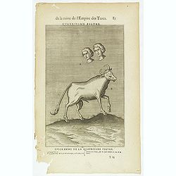
De la Ruine de l'Empire des Turcs Quatriesme figure / Epigramme de la Quatriesme figure. (85)
Sought-after copper engraved plate taken from Laonikos Chalcocondyle’s "L'histoire de la décadence de l'empire grec et establissement de celuy des Turcs", th...
- $50 / ≈ €47
Place & Date: Paris, Mathieu Guillemot, 1650
![Lovenstein. [Loevestein]](/uploads/cache/13749-250x250.jpg)
Lovenstein. [Loevestein]
View of the castle Loevestein, near Gorinchem.. On the sky, three hands holding a quill, a stone and a stick are depicted. With a verse in two languages underneath the pi...
- $60 / ≈ €56
Place & Date: Frankfurt, 1624
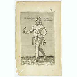
Malabar.
Small map illustrating the southwestern sea coast of India. Oriented with East on top, surrounded by text in Dutch.Included in the rare book : Wereld Spiegel, waer in ver...
- $200 / ≈ €187
Place & Date: Amsterdam, Cloppenburch, 1621
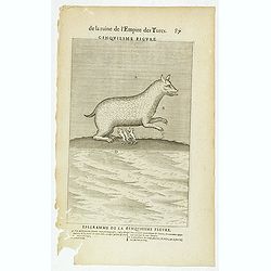
De la Ruine de l'Empire des Turcs Cinquiesme figure / Epigramme de la Cinquiesme figure. (87)
Sought-after copper engraved plate taken from Laonikos Chalcocondyle’s "L'histoire de la décadence de l'empire grec et establissement de celuy des Turcs", th...
- $50 / ≈ €47
Place & Date: Paris, Mathieu Guillemot, 1650
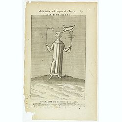
De la Ruine de l'Empire des Turcs Sixiesme figure / Epigramme de la Sixiesme figure. (89)
Sought-after copper engraved plate taken from Laonikos Chalcocondyle’s "L'histoire de la décadence de l'empire grec et establissement de celuy des Turcs", th...
- $50 / ≈ €47
Place & Date: Paris, Mathieu Guillemot, 1650
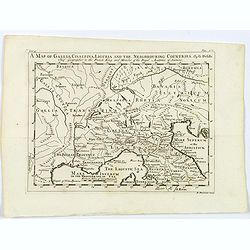
A Map of Gallia, Cisalpina, Liguria and the Neighbouring Countries.
A map of eastern France, Provence, northern Italy, then to Tuscany, whilst also showing northern Switzerland and Bavaria in Roman times. Showing Roman Provinces, a mileag...
- $50 / ≈ €47
Place & Date: London, ca 1749
Soil map - Pennsylvania, Lockhaven sheet.
Early color lithographed soil map by Julius Bien & Co. in New York for Department of Agriculture. Legends at side give detail on soil type, etc. They also include int...
- $50 / ≈ €47
Place & Date: New York, 1903
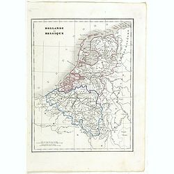
Hollande et Belgique.
Detailed Holland and Belgium map, prepared by Charles V. Monin (fl.1830-1880) a French cartographer of Caen and Paris. Published in Atlas Universel de Géographie Ancienn...
- $50 / ≈ €47
Place & Date: Paris, 1845
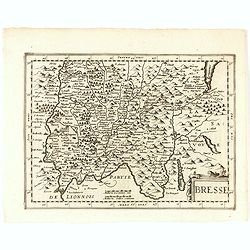
Bresse.
Early map of Eastern France and part of Switzerland. Geneva in upper right corner. With Latin text on verso. Engraved by Petrus Kaerius. Shortly after the publication of ...
- $50 / ≈ €47
Place & Date: Amsterdam, 1632
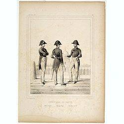
Officiers de santé. Médecin Adjoint - Chirurgien Major - Pharmacien Aide M.or.
Plate # 48 of the series "Uniformes de l'Armée Francaise en 1848", drawn and lithographed by Janet-Lange, printed by d'Aubert & C.ie. Figurs a medical offi...
- $50 / ≈ €47
Place & Date: Paris, 1846
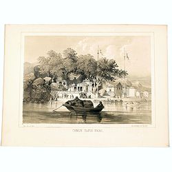
Chinese Temple, Macao.
A pleasant view of the important Chinese Temple in Macao, taken from the water with a junk in the foreground and many sampans and junks moored in front of it, with visito...
- $75 / ≈ €70
Place & Date: Philadelphia, 1856