Browse Listings in World Maps
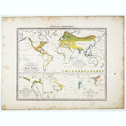
Distribuzione geografica delle Pianta coltivate . . .
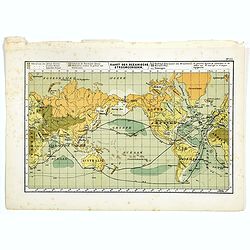
Uncommon world map in Mercator projection representing food resources on 3 inset maps, prepared by Francesco Costantino Marmocchi. Above the map "Geografia Commercia...
Place & Date: Genova, Paolo Rivara fu Giacomo, 1858
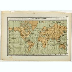
Kaart der Isodynamen.
One of the earliest thematic maps published in the Netherlands from "Atlas der natuurkundige aardrijkskunde. . .". prepared by Nicolaas Wilhelmus Posthumus. The...
- $35 / ≈ €33
Place & Date: Amsterdam, C.L. Brinkman, 1883
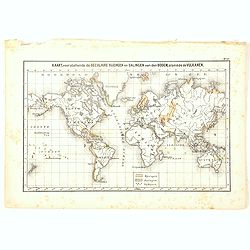
Kaart der Oceanische Stroomgebieden.
One of the earliest thematic maps published in the Netherlands from "Atlas der natuurkundige aardrijkskunde. . .". prepared by Nicolaas Wilhelmus Posthumus. The...
- $35 / ≈ €33
Place & Date: Amsterdam, C.L. Brinkman, 1883
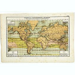
Kaart, voorstellende de Seculaire Rijzingen en Dalingen van den Bodem, alsmede de Vulkamen.
One of the earliest thematic world maps published in the Netherlands from "Atlas der natuurkundige aardrijkskunde. . .". prepared by Nicolaas Wilhelmus Posthumu...
- $35 / ≈ €33
Place & Date: Amsterdam, C.L. Brinkman, 1883
Kaart der Oceanische Stroomgebieden.
One of the earliest thematic maps published in the Netherlands from "Atlas der natuurkundige aardrijkskunde. . .". prepared by Nicolaas Wilhelmus Posthumus. The...
- $35 / ≈ €33
Place & Date: Amsterdam, C.L. Brinkman, 1883
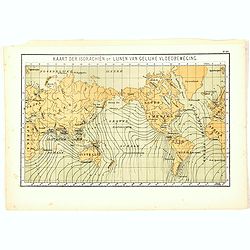
Kaart der Isorachiën of Lijnen van Gelijke Vloedbeweging.
One of the earliest thematic world maps published in the Netherlands from "Atlas der natuurkundige aardrijkskunde. . .". prepared by Nicolaas Wilhelmus Posthumu...
- $35 / ≈ €33
Place & Date: Amsterdam, C.L. Brinkman, 1883
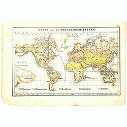
Kaart van de Hoofdgodsdiensten.
One of the earliest thematic world maps published in the Netherlands from "Atlas der natuurkundige aardrijkskunde. . .". prepared by Nicolaas Wilhelmus Posthumu...
- $35 / ≈ €33
Place & Date: Amsterdam, C.L. Brinkman, 1883
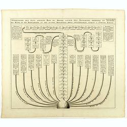
Succession des plus anciens Rois du monde . . .
Showing successions of the oldest kings of the world, with a globe in lower part of the print. Copper engraved plate from "Atlas Historique". Zacharie Chatelain...
- $45 / ≈ €42
Place & Date: Amsterdam, 1720
Il mondo cocsciuto dagli antichi e le laggiori antiche monarchie Persiana, Macedone, Romana . . .
A rare double-page map of the Ancient World. From l'Atlante Storico, Letterario, Biografico, Archeologico. . . with attributions by Giambatista Albrizzi.Lower left a col...
Place & Date: Venice, 1840
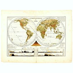
Hypsometrisch Overzicht der Aarde.
One of the earliest thematic world maps published in the Netherlands from "Atlas der natuurkundige aardrijkskunde. . .". prepared by Nicolaas Wilhelmus Posthumu...
- $50 / ≈ €47
Place & Date: Amsterdam, C.L. Brinkman, 1883
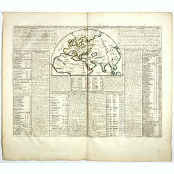
Carte pour servir à l'intelligence de l'histoire de la chronologie et de la géographie des empires des Assiriens, des Perses, des Egyptiens et des Chinois.
Interesting sheet with a map of the classical world showing the empires of the Assyrians, Persians, Egyptians and Chinese, with descriptive French text, from Chatelain's ...
- $75 / ≈ €70
Place & Date: Amsterdam, 1720
![[No Tittle] Map of the Easteren Hemisphere.](/uploads/cache/29385-250x250.jpg)
[No Tittle] Map of the Easteren Hemisphere.
Nice small map of eastern hemisphere by Johannes Walch in his rare Allgemeiner Atlas Nach den bewährsten Hülfsmitteln und astronomischen Ortsbestimungen…, edition of ...
- $120 / ≈ €112
Place & Date: Augsburg, 1812
![[World map with oceanic currents].](/uploads/cache/46149-250x250.jpg)
[World map with oceanic currents].
Alexey Afinogenovich Ilyin was a lieutenant general and cartographer (1832-1889). In 1856, after graduating from the Academy of the General Staff, he was at the military ...
- $100 / ≈ €94
Place & Date: St. Petersburg, 1899
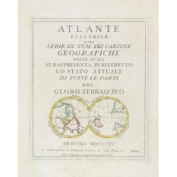
(Title page) Mappamondo sul Piano dell' Equatore. - Atlante Tascabile o sia Serie di Num. XXI Cartine Geografiche nelle quali si. . .
Engraved title page with in lower part a double polar projection (50x95mm.) from the rare atlas Atlante Tascabile o sia Serie di Num. XXI Cartine Geografiche nelle quali ...
- $100 / ≈ €94
Place & Date: Rome, 1823
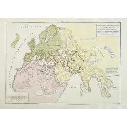
Hémisphère Oriental..
Map of the Eastern Hemisphere, including numerous exploration routes with a notation of important recent discoveries.Australia is partially mapped and then completed into...
- $150 / ≈ €140
Place & Date: Paris, 1786
Carte pour servir à l'intelligence de l'histoire de la chronologie et de la géographie des empires des Assiriens, des Perses, des Egyptiens et des Chinois.
Interesting sheet with a map of the classical world showing the empires of the Assyrians, Persians, Egyptians and Chinese, with descriptive French text, from Chatelain's ...
Place & Date: Amsterdam, 1720
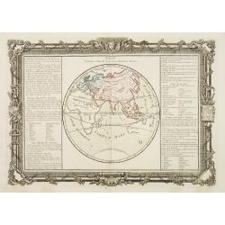
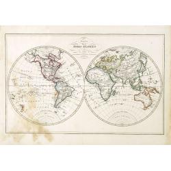
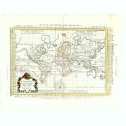
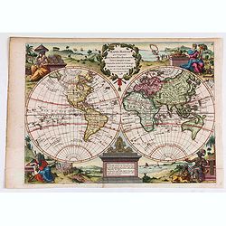
Mappamondo Carta d'Insieme.
Uncommon double hemisphere pole projection prepared by Francesco Costantino Marmocchi. Above the map "Geografia Commerciale". With a color code underneath the m...
Place & Date: Genova, Paolo Rivara fu Giacomo, 1858
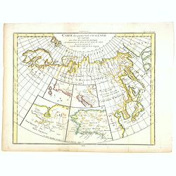
Carte des parties Nord et Est de L'Asie. . .
Five maps on one sheet, showing the Northern Russian territories in Europe and Asia, including the western coastline from Siberia, with Japan and Korea with the island of...
- $100 / ≈ €94
Place & Date: Paris, 1779
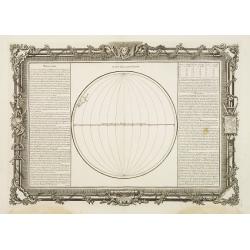
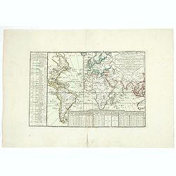
Suite de la Longitude.
Decorative map showing one hemisphere divided into meridians.Left and right a box with further information's about longitude.Prepared by Buy de Mornas, who was a professo...
Place & Date: Paris, 1762
Selling price: $65
Sold in 2013
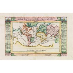
Division Générale et Naturelle de la Terre, Suivant les Anciens.
Decorative chart showing the world as it was known by the ancients.Left and right a box with geographical information about Europe, Asia and Africa.Prepared by Buy de Mor...
Place & Date: Paris, 1762
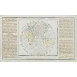
Carte pour servir a L'Histoire Philosophique et Politique..
Showing the eastern hemisphere, including Australia. With inset map of India and Sri Lanka in the Indian Ocean.The focus of the chart is European trade and commerce with ...
- $150 / ≈ €140
Place & Date: Paris, 1780
The World on Mercator's projection.
World map in Mercator-projection, published by "The London Printing and Publishing Company". Drawn and engraved by John Rapkin.
- $110 / ≈ €103
Place & Date: London, 1854
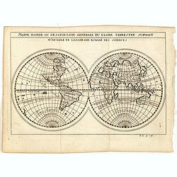
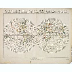
Mappe monde ou description generale du globe terrestre suivant Mr.de Lisle de l'academie Royale des sciences.
Scarce small map of Europe based on cartography of Guillaume Delisle (. Published in "Nouveau traité de geographie par M**** ", published by La veuve Lottin &a...
- $200 / ≈ €187
Place & Date: Paris, 1752
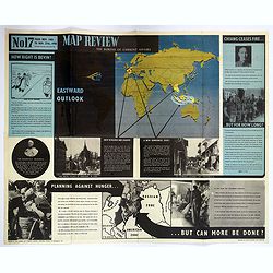
Map Review No.17. Eastwood Outlook.
A large double sided 'current affairs' poster. One side features a eastern hemisphere world map, and deals with matters arising in South East Asia, the Far East and Europ...
- $180 / ≈ €168
Place & Date: London, 1946
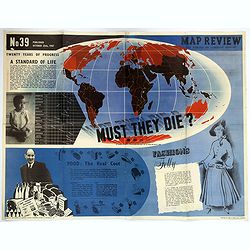
Map Review No.39. - Twenty Years of Progress, 'A Standard of Life'.
A large fully colored double-sided poster of the world colored to highlight the number of children who die each year before the age of one. This is accompanied by a short...
- $200 / ≈ €187
Place & Date: London, 1947
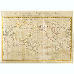
Carte Générale de Voyage Pittoresque Autour du Monde.
A map of the world centered on the Pacific Ocean. Engraved by Ambroise Tardieu.Jules Sébastien César Dumont d'Urville (1790 – 1842) was a French explorer, naval offic...
- $125 / ≈ €117
Place & Date: Paris, ca. 1840
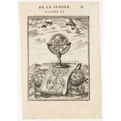
Equateur.
Appealing print centered on an armillary sphere. The latter sits atop a map of the world which clearly shows California as an island. In addition to this curious feature,...
- $200 / ≈ €187
Place & Date: Paris, 1683
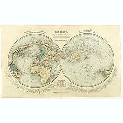
The Earth projected on the horizon of London.
Double hemisphere orientated on the north and south poles.
- $150 / ≈ €140
Place & Date: London, 1850
![[World map in showing currents with Ottoman script]](/uploads/cache/44322-250x250.jpg)
[World map in showing currents with Ottoman script]
Post card size world map in Mercator projection showing the currents in Atlantic and Pacific Oceans in Ottoman script prepared by Mehmet EŞREF in a small atlas : عمو...
- $150 / ≈ €140
Place & Date: Istanbul, 1325 or 1909
![[Titlepage] Nomenclator Ptolemaicus..](/uploads/cache/06436-250x250.jpg)
[Titlepage] Nomenclator Ptolemaicus..
Title page from a Ortelius Atlas part called: Nomenclator , containing a register of place names in antiquity. Letterpress with copper engraved print (60x60mm) of the eas...
- $150 / ≈ €140
Place & Date: Antwerp, 1609
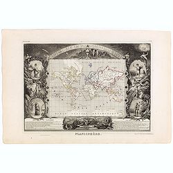
Planisphère.
One of the last decorative maps of the area. In side panels representations of the four seasons. In original o.l. color, from his "Atlas Universel Illustré". T...
Place & Date: Paris, A. Combette, 1852
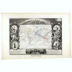
Planisphère.
One of the last decorative maps of the area. In side panels representations of the four seasons. In original out line color, from his "Atlas Universel Illustré"...
- $175 / ≈ €164
Place & Date: Paris, 1845-1860
Karta öfver Jord-Globen (World map)
An very rare double hemisphere world map. This is an heavenly updated version of his map of 1817 and is now dated 1848, Australia with new nomenclature and the old title ...
- $250 / ≈ €234
Place & Date: A. Wiborgs förlag, Stockholm, ca. 1848
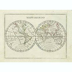
Mappamondo.
Charming world map in double hemisphere from the rare atlas Atlante Tascabile o sia Serie di Num. XXI Cartine Geografiche nelle quali si rappresenta in ristretto lo Stato...
- $250 / ≈ €234
Place & Date: Rome, 1823
Freedom of the Air.
A world map packed with information about aviation and the aluminum industry.The use of aircraft in warfare, especially in the roles of close ground support and strategic...
- $230 / ≈ €215
Place & Date: United-States, 1943
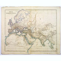
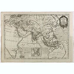
Orbis Veteribus Notus.
A detailed steel engraved map of the ancient world, stretching from Europe eastwards to the Black Sea and beyond, southwards through northern Africa, Arabia, India, and S...
Place & Date: London, 1839
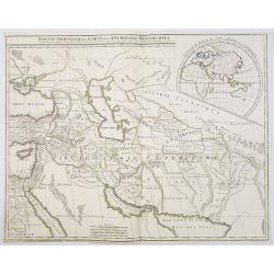
Partie Orientale de la Carte des Anciennes Monarchies. . .
This map depicts the eastern part of the Ancient World, Partie Occidentale de la Carte des Anciennes Monarchies including the Near East, Cyprus, Black Sea, Caspian Sea, I...
Place & Date: Paris, ca. 1800
![[ Pictorial world map ]](/uploads/cache/44376-250x250.jpg)
[ Pictorial world map ]
Pictorial world map includes decorative title cartouche and compass rose. Drawn by Jacques Liozu, a French illustrator who drew a number of maps in this style in 1951, in...
- $220 / ≈ €206
Place & Date: Paris, 1951
![[Set of two maps in north and south pole projections, with orographic profile of mountains and oceans, with volcanos with Ottoman script]](/uploads/cache/44325-250x250.jpg)
[Set of two maps in north and south pole projections, with orographic profile of mountains and oceans, with volcanos with Ottoman script]
Two postcard size maps with north and south pole projections, below each map orographic profiles of mountains and oceans, with volcanos. The maps are in Ottoman script pr...
- $200 / ≈ €187
Place & Date: Istanbul, 1325 or 1909
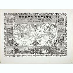
Monde Entier, Par J. Henry Dressine et Ecrit Chez L' Auteur Par A. Clement.
Decorative uncommon 19th century double hemisphere map of the word with ten vignettes surrounding the map. The vignettes show a naval battle, and a land battle with a com...
- $300 / ≈ €281
Place & Date: Paris, 1834
![[Set of two maps showing world in Mercator projection, with Ottoman script]](/uploads/cache/44328-250x250.jpg)
[Set of two maps showing world in Mercator projection, with Ottoman script]
Two postcard size maps showing the entire world in Mercator projection. The maps are in Ottoman script prepared by Mehmet EŞREF in a small atlas : عمومولاياة�...
- $200 / ≈ €187
Place & Date: Istanbul, 1325 or 1909
Carte du globe terrestre où les terres de l'hémisphère méridl sont supposées être vues à travers celles de l'hémisphère septentl.
Important single hemisphere world map prepared by Buache's with Sea of the West. Published in Buache's "Considérations géographiques et physiques", one of his...
- $500 / ≈ €468
Place & Date: Paris, 1746
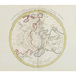
Carte Phisique de la Mer Glaciale Arctique. . .
Very unusual thematic map designed to illustrate the watersheds of the world, after Buache and prepared by J.B.Nolin and published by Monhare for his Atlas Général a l'...
- $300 / ≈ €281
Place & Date: Paris, 1783
Carte des lieux où les différentes longueurs du pendule à secondes ont été observées . . .
World map. Published in Buache's "Considérations géographiques et physiques", one of his most important and original cartographic works.The map projects the c...
- $500 / ≈ €468
Place & Date: Paris, 1746
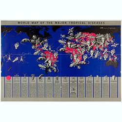
World Map of the Major Tropical Diseases.
A gruesome overview of some of the world’s deadliest tropical diseases designed by Boris Artzybasheff.This graphic world map uses hideous imagery and vivid color to hig...
- $270 / ≈ €253
Place & Date: London, 1944
Carta Hydrographica oder Algemeine Welt. . .
World map in Mercator projection. Showing California as an island. In the upper left and right-hand corner two ships. The map is showing the important trade routes.
Place & Date: Augsburg, 1720
Planisfero (Tav III)
A large-format world map with a key to the steamship routes, telegraph lines and land routes in Europe. Finely engraved and beautifully colored and was prepared by Girola...
- $350 / ≈ €328
Place & Date: Rome, 1858
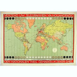
Verzend uw telegrammen via Holland Radio Den Nationalen weg. Gemakkelijk -Zeker - Snel.
Poster showing a world map in Mercator projection. In top and bottom clocks showing the time zones. Red lines connecting The Netherlands with different major hubs in Amer...
- $380 / ≈ €356
Place & Date: The Netherland, 1939
![[Manuscript] Mappe - Monde - Novembre 1838.](/uploads/cache/23277-250x250.jpg)
[Manuscript] Mappe - Monde - Novembre 1838.
Fine manuscript double hemisphere world map. With an over sized Australia and no place names on the continents. With the signature of the author Suhardbetween the hemisph...
Place & Date: Paris, 1838
Mappemonde sur la projection de Mercator Dressee par Mr Lapie, Lieut. Colonel. et Mr Lapie, fils capitaine d'Etat major, Paris 1832.
Very detailed world map with Australia in the center and prepared by Pierre M. Lapie (fl. 1779 - 1850) and his son Alexandre Emile Lapie (fl. 1809 - 1850).Engraved by Lal...
- $450 / ≈ €421
Place & Date: Paris, 1832
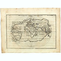
Designatio Orbis Christiani
Planispherical world map broadly based on Ortelius and similar to Hondius's Atlas Minor map of the same title. It shows most of the world, excluding the west coast of Nor...
- $450 / ≈ €421
Place & Date: France, ca 1607
Carte Reduite du globe Terrestre. . .
Fine world map in a Mercator projection. From Voyages autour du monde et vers les deux pôles par terre et par mer.. by Pierre Marie François vicomte de Pages (1748-1793...
Place & Date: Paris, ca 1782

Carriers of the New Black Plague.
A powerful satirical commentary on totalitarian control of speech from the first issue of Ken Magazine. "Caught here in all their peculiar beauty by the soul searchi...
Place & Date: Chicago, 1938
![[Mussolini Celebrates Pearl Harbor] Grande Carta Del Pacifico](/uploads/cache/48536-250x250.jpg)
[Mussolini Celebrates Pearl Harbor] Grande Carta Del Pacifico
A world map issued four days after the Japanese attack on Pearl Harbor, which led England and the United States to declare war on Japan, this message from Mussolini, cele...
- $500 / ≈ €468
Place & Date: Rome / Milan, 1941
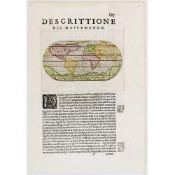
Descittione del Mappamondo.
A fine miniature oval map of the world engraved by Girolamo Porro. It is a reduction of Giovanni Francesco Camocio's superb large map of 1567, one of the last in the long...
- $450 / ≈ €421
Place & Date: Venice, ca.1586
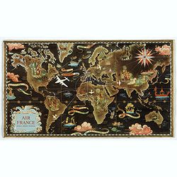
![Air France [poster].](/uploads/cache/44299-250x250.jpg)
Air France [poster].
A superb double-sided Air France folding poster, featuring bold colored graphics. Published as a serious piece of marketing put out by the airline showing off their state...
- $500 / ≈ €468
Place & Date: Paris, 1955
![Air France [poster].](/uploads/cache/44696-250x250.jpg)
Air France [poster].
A superb double sided Air France folding poster, featuring bold colored graphics. Published as a serious piece of marketing put out by the airline showing off their state...
- $500 / ≈ €468
Place & Date: Paris, 1955
Il Mappamondo o sia Descrizione Generale del Globo Ridotto..
Attractive Italian map presented on Mercator's projection and featuring the voyages of Cook and Bougainville. Greenland is shown connected to North America and Alaska is ...
- $750 / ≈ €702
Place & Date: Venice, 1774
![Mappa Mondo tagliato sulpiano di unmeridiano Emisfero Occidentale. [togther with] … Orientale.](/uploads/cache/48543-250x250.jpg)
Mappa Mondo tagliato sulpiano di unmeridiano Emisfero Occidentale. [togther with] … Orientale.
World map on two sheets - Western Hemisphere (North and South America, Oceania, Greenland) and Eastern Hemisphere (Europe, Africa, Asia, Australia). Published by Pazzini,...
- $500 / ≈ €468
Place & Date: Siena, 1796
Mappe-Monde, ou Carte Generale du Monde: Dessignée en deux plans Hemispheres Par le Sr. Sanson d'Abbeville, Geographe ordinaire de sa Majesté.
Sanson's first world maps, dated 1651 and 1652, were issued separately and then in collections of mapsThe map is one of the first to distinguish the Great Lakes, all five...
Place & Date: Paris, 1651
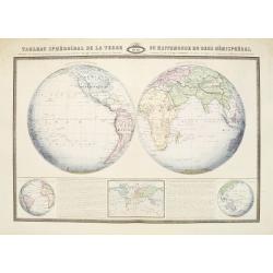
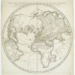
Tableau Sphéroïdal de la Terre ou Mappemonde en deux Hémispères. . .
Large steel engraving presenting the whole World in different projections, namely showing the convexity of the Earth.At the bottom a temperature contour map of the world ...
Place & Date: Paris, 1860
Mappe Monde qui Comprend les Nouvelles..
Charming double hemisphere map with the female representations of the continents adorning each corner published by George Louis Le Rouge, active in Paris 1740-1780 .The N...
- $600 / ≈ €561
Place & Date: Paris, 1748
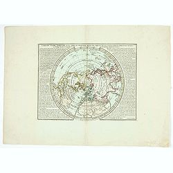
Hémisphère Supérieur de la Mappemonde projetée sur l'Horizon. . .
Hemisphere on a partial polar projection. The Northern Hemisphere (of 2) is centered on Paris emphasizing the continents. Hemisphere measures 24.5. Alaska is shown as an ...
Place & Date: Paris, 1774
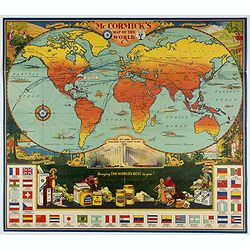
McCormick's Map of the World.
Colorful promotional map of the 20th century spice trade.What better way to showcase the global composition of a multi-national company than with a world map? This lovely...
Place & Date: United-States, 1931
![[Board game] - La course autour du Monde.](/uploads/cache/48521-250x250.jpg)
[Board game] - La course autour du Monde.
Very rare French board game - no other copies known. The game consists of 50 fields linked to the lines of longitude. A globe lies in the center of the board to symboli...
Place & Date: Paris, ca. 1900
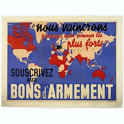
Nous vaincrons parce que nous sommes les plus forts. Souscrivez aux bons d'armement.
We win because we are the strongest. Support good armaments". Quote by the French Prime Minister Paul Reynaud. French wartime propaganda poster. colored world map - ...
- $600 / ≈ €561
Place & Date: Paris ca 1939
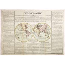
Tableau général et raisonné du Globe Terrestre. . .
Uncommon double hemisphere world map showing the tracks of Cook (1771-73, 1771 and Clarcke (1779). Surrounded by geographical information for each continent along with us...
- $1000 / ≈ €936
Place & Date: Paris 1792
Abbozzo della mappa dei viaggi di Marco Polo nella sala dello Scudo del Palazzo ducale di Venezia.
Rare map showing the travels of Marco Polo, taken from "Sulle antiche mappe idro-geografiche lavorate in Venezia: Commentario.", by Placido Zurla (1769-1834), p...
Place & Date: Venice, 1818
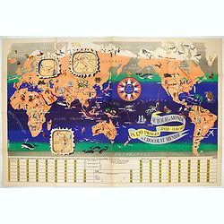
Le Tour du Monde en 120 Images Grand Concours du Chocolat Menier.
This highly unusual and rather novel pictorial map of the world was created by J.B. Jannot and published by Agence Française de Propagande as a promotional item for Meni...
Place & Date: Paris, 1956
![[TAI travel poster]](/uploads/cache/44893-250x250.jpg)
[TAI travel poster]
A whimsical travel poster for "Transport Aeriens Intercontinentaux" (TAI), published in Paris in 1960, by Luc-Marie Bayle (1914-2000). The poster depicts a twin...
- $700 / ≈ €655
Place & Date: Paris, 1960
Novo Globo Terraqueo.
Double hemisphere world map with a broad banner carrying the title. In the ocean are currents shown and in top and bottom are diagrams showing the zones. A rare map.
- $750 / ≈ €702
Place & Date: Italy, ca. 1755
Planisphère terrestre.
A huge (2 meters) world map representing Asia and America in the center, Europe and Africa at left and right hand of the map. Published by the Service hydrographique in 1...
- $800 / ≈ €749
Place & Date: Paris, Service hydrographique, 1902-1914
Orbis Terrae compendiosa descriptio.
Modern world map by Rosaccio, consisting of two hemispheres enclosed within a plain border. The engraving is sharp and neat, and is a skilful reduction of Rumold Mercator...
- $1000 / ≈ €936
Place & Date: Venise, 1598/1713
Le tour du monde en 120 images, grand concours du Chocolat Menier.
Pictorial map of the world centered on the Pacific with a route around the globe, starting and finishing in Paris. The map features 120 images of explorers, plants, anima...
- $750 / ≈ €702
Place & Date: Paris, 1956
Mappe-Monde ou Description du Glôbe Terrestre Assujettie aux Observs Astronoms.
Double hemisphere map with a curious shape for Australia, from Atlas moderne portatif composé de vingt-huit cartes sur toutes les parties du globe terrestre .. A l'usage...
Place & Date: Paris, Prudhomme, Levrault, Debray, 1806
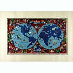
AIR France réseau arérien mondial.
Original lithograph advertising planisphere cardboard from AIR France. The map is designed by Lucien Boucher and is in fact a reduced version of his larger format poster....
- $800 / ≈ €749
Place & Date: Imprimerie Perceval, Paris, 1938
AIR France - Sur les ailes d'Air France découvrez le monde à votre tour.
Promotional poster of a double hemisphere world map designed by Lucien Boucher for AIR France. The map depicts the entire world in rich blues and burgundies with gold hig...
Place & Date: Perceval, Paris, 1952
The world, including the discoveries made by Capt. Cook.
Uncommon double-hemisphere world map depicting the voyages and discoveries of Captain James Cook. There are numerous notations throughout and the tracks of Cook's three v...
- $1000 / ≈ €936
Place & Date: London, 1781

Nous vaincrons parce que nous sommes les plus forts. Souscrivez aux bons d'armement.
"We win because we are the strongest. Support good armaments". Quote by the French Prime Minister Paul Reynaud. French wartime propaganda poster. color printed ...
Place & Date: Paris, M.Dechaux, ca 1939
Selling price: $105
Sold in 2019
L'Hydrographie ..la Surface du Globe Terrestre.
An unusual double hemisphere hydrological map of the world - the earliest of the world prepared by the great French mapmaker Nicolas Sanson. Of particular interest is the...
- $750 / ≈ €702
Place & Date: Paris, 1652