Browse Listings in Europe > Netherlands

Descrittione di M. Lodovico Guicciardini patritio Fiorentino, di tutti i Paesi Bassi,...
Second Italian edition (variant B) and first Plantin edition (1st Silvius 1567) and the most sought-after edition of the famous description of the Low Countries, updated ...
Place & Date: Antwerp, Plantin, 1581
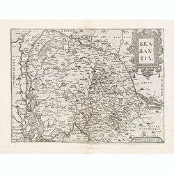
Brabantia.
Map of Brabant from Guicciardini's "Description de touts les Pais-Bais" edited by Plantin in 1582. The map drawn after Ortelius' map of Brabant, and after the l...
- $275 / ≈ €257
Place & Date: Antwerp, 1582
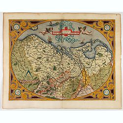
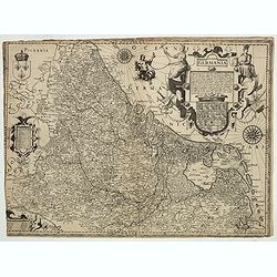
Descriptio Germaniae Inferioris.
The oval map is surrounded by a strapwork frame and the title, adorned with ribbons, is held aloft by two winged cherubs.According to P. Meurer based on de Jode's 12 shee...
- $550 / ≈ €515
Place & Date: Antwerp, 1587

The hanging of the head of police Jean Grauwels in Brussels, 11 february 1569.
Print relating to Brussels during the first decades of the eighty year war between Spain and the Low Countries: (plate 18). This plate shows the hanging of the head of po...
Place & Date: Cologne, ca. 1590

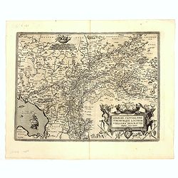
Gelriae, Cliviae, Finitimorumque Locorum Verissima..
East to the top. Fine map of Geldria and Limburg, prepared by Christian s'Grooten. Very fine title cartouche lower right with painter's utensils around the cartouche. ...
Place & Date: Antwerp, 1598

Hollandiae Antiquorum Catthorum..
This map shows Holland in great detail, including small towns, walled cities, rivers and lakes (many of which were reclaimed in the 17th century, and no longer exist). A ...
Place & Date: Antwerp, 1598
Gelriae, Cliviae, Finitimorumque Locorum Verissima..
East to the top. Fine map of Gelderland and Limburg, prepared by Christian s'Grooten. Very fine title cartouche lower right with painters utensils around cartouche.Dare t...
Place & Date: Antwerp, 1598
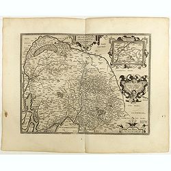
Brabantiae Descriptio.
In an inset Mechelen and surroundings. Decorative scale and title cartouche with dedicational initials, which may refer to Laurentius Michaelis, who may be connected with...
Place & Date: Antwerp, 1598
Inferior Germania.
Very rare map of the Benelux, centered on the Netherlands. According to van der Heijden only known in 6 examples. Two compass-roses with rumb lines but without the names ...
Place & Date: Amsterdam,ca. 1600
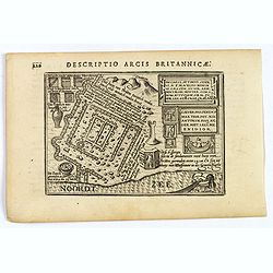
Descriptio Arcis Britannicae.
An original early 17th century copper engraved miniature antique map of the Roman remains in the sand dunes near Katwijk aan Zee in south Holland by Petrus Bertius. In Ro...
- $100 / ≈ €94
Place & Date: Amsterdam, 1606