Browse Listings in Europe > Netherlands

A new mape of Ye XVII Provinces of Low Germanie.
Showing all 17 Provinces of the Netherlands before the split between Spain and the Protestant Provinces under the House of Orange. The map was published while the war of ...
- $2300 / ≈ €2152
Place & Date: London, George Humble, 1626 [1627

Kaerte van Bergen op Zoom, Steenbergen ende de nieuwe fortificatien gemaeckt tot bevrÿdinge van 't landt van ter Tolen in tjaar 1628.
Very detailed and scarce map showing Bergen Op Zoom, Steenbergen and its surrounding countryside. North to the left side.
- $400 / ≈ €374
Place & Date: Amsterdam, after 1628
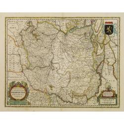
Novissima et Accuratissima Brabantiae Ducatus Tabula.
North is to the right. Like all other maps of Brabantiae Ducatus, it encloses the area between the rivers Rhine, Maas and Schelde, with Namur as the most southern town. O...
- $350 / ≈ €328
Place & Date: Amsterdam, 1629

Zelandia Comitatus.
Based on the map by Van Deventer. For the first time a road connection between Flushing, Middelburg and Arnemuiden is shown. Mercator pays much attention to the area of s...
Place & Date: Amsterdam, 1630
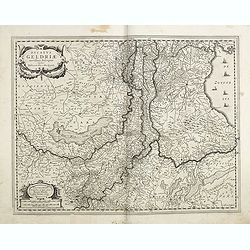
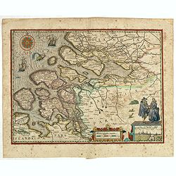
Ducatus Geldriae novissima. . .
Early map of Gelderland, but also including Utrecht, and parts of Brabant. Shows many cities (like Nijmegen, Eindhoven, Zutphen, Zwolle, etc), roads, rivers, woods, regio...
- $350 / ≈ €328
Place & Date: Amsterdam, 1629-1630
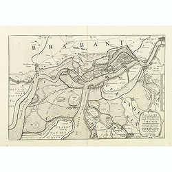
Pas-Caert vande ghelegetheyt vande Schans te Santvliet, Vertoonede de verdroncken overwaeterde Landen, nieuw aengewasse gorsingen,. . .
Showing the surrounding countryside of the cities of Antwerp, Santvliet, Lillo, Bergen op zoom, etc. The map is ponctuated by several fortifications to indicate the main ...
- $400 / ≈ €374
Place & Date: Amsterdam, 1630
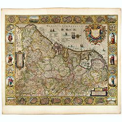
Belgii sive Germaniae Inferioris accuratissima tabula.
Very rare and very decorative map with in the right and left borders costumed figures and town plans alternately. In top and bottom border town plans and views.Separate p...
Place & Date: Amsterdam, 1631

Belgii sive Germaniae Inferioris accuratissima tabula.
Very rare and very decorative map with in the right and left borders costumed figures and town plans alternately. In top and bottom border town plans and views.Separate p...
Place & Date: Amsterdam, 1631

Zeelandiae Comitatus.
Rare map of Zeeland, with inset view of the town of Middelburg topped with costumed figures. This is the second edition published by Claes Jansz. Visscher. The first edit...
Place & Date: Amsterdam, 1617-1631
(Zeeland)
Rare map of Zeeland, first issued by Petrus Kaerius, than by Claes Jansz. Visscher. The copper plate was previously made by an anonymous engraver, and than came into the ...
- $1050 / ≈ €983
Place & Date: Amsterdam, 1631