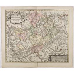
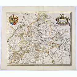
Nassovia Principatus Cum omnibus ei pertinentibus Comitatibus Dominiis ac Praefecturis ut et Confiniis intra Lahnun, Rhenum, et Moenum Flumina, ad situm verum exacte delineatus a Joh. Jac. Stetter. U.J.L. Idstenio-Nassovio . . .
Decorative map of the area between the rivers Rhine and Meuse, including Mainz, Koblenz, Frankfurt, Saarbrucken, etc.Includes an elaborate cartouche and coat of arms.The ...
- $150 / ≈ €140
Place & Date: Amsterdam, 1720
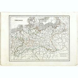
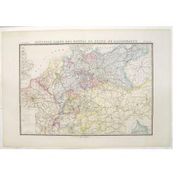
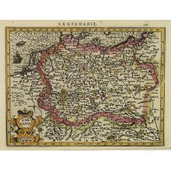
Prusse.
Detailed map of Prussia, prepared by Charles V. Monin (fl.1830-1880) a French cartographer of Caen and Paris. Published in Atlas Universel de Géographie Ancienne &c ...
- $40 / ≈ €37
Place & Date: Paris, 1845
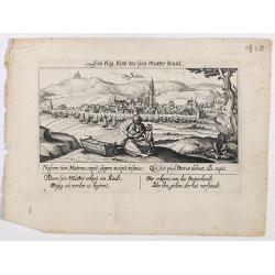
Sontra.
A panoramic view of the city Sontra in Hessen . With motto "ein klug Kind das sein Mutter kennt". On the foreground, a woman with two children and a crypt. With...
- $60 / ≈ €56
Place & Date: Frankfurt, 1623-1778
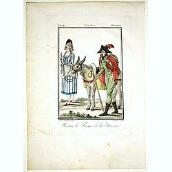
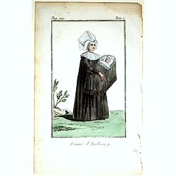
Homme & Femme de la Baviere.
Originally hand-colored mezzotint from 'Costumes civils actuels de tous les peuples connus'. Engraved by Félix Mixelle after Jacques Grasset de Saint-Sauveur.As an etche...
- $50 / ≈ €47
Place & Date: Paris,1806
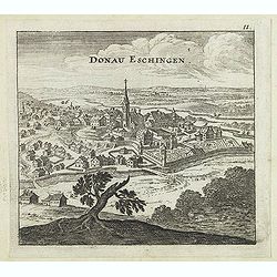
Donau Eschingen. / Der donaü stränd.
Two views pasted on recto and verso of a larger sheet of paper. On recto panoramic view of Donaueschingen a German town in the Black Forest.On verso a map of the Danube a...
- $75 / ≈ €70
Place & Date: Nuremberg, Jacob Sandrart, 1684
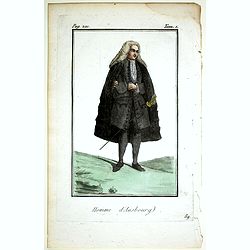
Homme d'Ausbourg.
Originally hand-colored mezzotint from 'Costumes civils actuels de tous les peuples connus'. After Jacques Grasset de Saint-Sauveur. As an etcher, drawer and writer, Gras...
- $50 / ≈ €47
Place & Date: Paris,1806
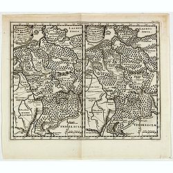
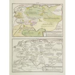
Populorum Germaniae . . .
Two maps of historical Germany on a single sheet. The two maps appear identical at first glance, but actually are a comparison of the region during the reigns of differen...
- $50 / ≈ €47
Place & Date: Amsterdam, 1661
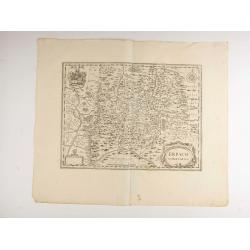
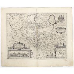
Erpach.
The town of Heidelberg is in most southern point on the map, including the rivers Rhine, Necker and Main.Rare issue published in Oxford. In 1680 the copper plates of Jans...
- $100 / ≈ €94
Place & Date: Oxford, 1680
La Germania, suoi ducati e dependenze . . . /Origine e derivazione de principali stati . . .
Two rare maps of ancient Germany: Top map: 160 x 235mm. Bottom map: 160 x 235mm.Prepared by Las Casas for l'Atlante Storico, Letterario, Biografico, Archeologico. . . wi...
- $25 / ≈ €23
Place & Date: Venice, 1840
Saxoniae Superioris
Impressive title cartouche with miniature panoramic view of Leipzig, coat of arms, putti and Mercury.Johann Baptist Homann born in Kammlach (1663). He was engraver, map-s...
- $150 / ≈ €140
Place & Date: Augsburg, 1720
![[Text page with imaginary towns in Westphalia and Hesse. CCLXXXIIII ].](/uploads/cache/37487-250x250.jpg)
[Text page with imaginary towns in Westphalia and Hesse. CCLXXXIIII ].
On recto, an imaginary view of towns in Westphalia (230x225mm.). Verso of towns in the province Hesse.Page from the richest illustrated Incunabula, the famous: Nuremberg ...
- $200 / ≈ €187
Place & Date: Nuremberg, 12 July 1493
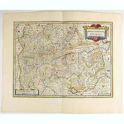
Monasteriensis Episcopatus.
A very detailed map of Germany centered on Linge. Showing Wessel to the top of the map, and Oldenburg to the right. North is oriented to the right. The map is further ado...
- $80 / ≈ €75
Place & Date: Amsterdam 1645
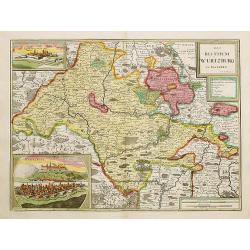
Das Bisthum Wurtzburg in Francken.
Rare map of Würzburg. With inset panoramic views of Würzburg and Köningshofen.The map is painted in strong colors. Clearly from an show-piece atlas produced for a weal...
- $1000 / ≈ €936
Place & Date: Nurenberg 1698
Nouvelle carte des routes de poste de l'Allemagne.
Large post road maps map of Germany, Poland, Austria, Franc, Switzerland, Austria and the Low Countries published by A. Logerot and engraved by C.Dyonnet.The mapsmakes di...
- $350 / ≈ €328
Place & Date: Paris, A. Logerot, c.1867
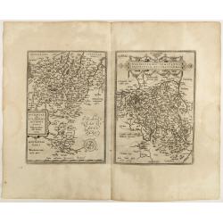
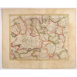
Buchaviae / Waldeccensis Comitatus.
Two maps on one sheet. The map on the left is based on Wolfgang Regerwyl's 1574 single fulda map. The map of Waldeck is based on Joist Moers map of 1572. Abraham Ortelius...
- $100 / ≈ €94
Place & Date: Antwerp, 1598
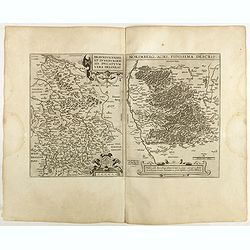
Braunsvicensis et Luneburgensis . . . (together with) Norimberg Agri,..
Two maps on one sheet, showing the regions of Braunschweig and Nuremberg from 'Theatrum Orbis Terrarum [Atlas of the Whole World]': published in Antwerp.Dare to go in Bla...
- $125 / ≈ €117
Place & Date: Antwerp, 1598
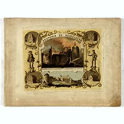
(Title page) Souvenir de Heidelberg.
Cover for a souvenir album with chromolithographed design and entitled: Souvenir de Heidelberg prepared by Louis Charles François. He emigrated with his family in May 17...
- $50 / ≈ €47
Place & Date: Graimberg, Heidelberg, ca. 1840
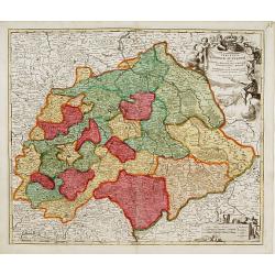
Wirtenberg Ducatus.
Map depicting the area south of Heidelberg, including Stuttgart, Ulm, etc.. and river Danube.A beautiful coat of arms and a splendid title cartouche decorated by three ch...
- $80 / ≈ €75
Place & Date: Amsterdam, 1645
La Germanie.
Small map of Germany, including Austria and part of Poland. Strap work title cartouche in the lower left.From the first French-text edition of Jodocus Hondius' Atlas Mino...
- $75 / ≈ €70
Place & Date: Amsterdam, 1608
Femme d'Ausbourg.
Originally hand-colored mezzotint from 'Costumes civils actuels de tous les peuples connus'. After Jacques Grasset de Saint-Sauveur. As an etcher, drawer and writer, Gras...
- $50 / ≈ €47
Place & Date: Paris,1806
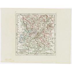
Cercle des quatre Electeurs.
Small detailed map of part of western Germany, centered on Frankfurt. From Atlas Portatif Universel, by Robert de Vaugondy.Edited by : "Au dépôt de Géographie, Ru...
- $25 / ≈ €23
Place & Date: Paris, 1799
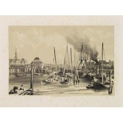
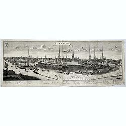
Hambourg.
Uncommon and decorative lithography of the harbor of Hamburg, published by Carl Johan Billmark and printed by Lemercier in Paris, 55 rue de Seine, the leading firm in Eur...
- $90 / ≈ €84
Place & Date: Paris, c.1859
![Sexta Etas Mundi. Constancia. [Constance CCXLI ]](/uploads/cache/33141-250x250.jpg)
Sexta Etas Mundi. Constancia. [Constance CCXLI ]
A very fine town view of Constance, in Germany, centered on the cathedral (198 x 520 mm).VERSO, seven insets of scientists, noblemen and Popes.Page from the richest illus...
- $1250 / ≈ €1170
Place & Date: Nuremberg, 12 July 1493
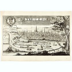
Treves (Trier)
Rare and decorative view of the city of Trier and the river Moselle in the foreground. In the upper left corner the coat of arms of France. The Jollain family was a famil...
- $400 / ≈ €374
Place & Date: Paris, 1680
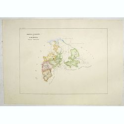
Provincia ecclesiastica di Colonia nella Prussia (Tav LXXXI)
This large-format south Germany Cologne map is finely engraved and beautifully colored and was prepared by Girolamo Petri, a lawyer who served as a senior official within...
- $250 / ≈ €234
Place & Date: Rome, 1858
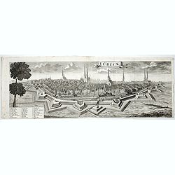
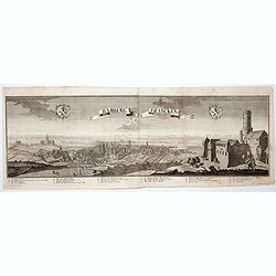
Lübeck.
A spectacular panoramic view of Lübeck, with legends numbered 1-28 in German. With the title in a banderol.After a design by Friedrich Bernhard Werner (1690-1776) who wa...
- $1500 / ≈ €1404
Place & Date: Augsburg, 1729
Hamburg.
A spectacular panoramic view of Hamburg, with legends numbered 1-19 and A-Z in German. With the title in a banderol.After a design by Friedrich Bernhard Werner (1690-1776...
- $2000 / ≈ €1871
Place & Date: Augsburg, 1729
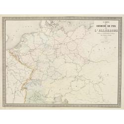
Carte des Chemins de Fer de l'Allemagne.
Fine map of Germany, The Netherlands and Eastern Europe, showing the early railway system of the area. From Atlas des Chemins de Fer published by Napoléon Chaix and pri...
Place & Date: Paris, 1863
Selling price: $2
Sold in 2011
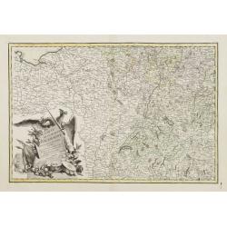
Carte de L'Empire D'Alemagne avec les Etats de Bohême..
Attractive map centered on the southwestern part of Germany, including Switzerland, Luxembourg and part of Austria.Decorative title cartouche with wine grapes, musical in...
- $75 / ≈ €70
Place & Date: Paris ca 1783

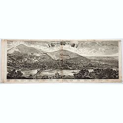
Lindau im Boden = See.
A spectacular panoramic view of Lindau on Lake Constance (or Bodensee) in Bavaria, with legends numbered 1-20 in German. With the title in a banderol. In the center its o...
- $1500 / ≈ €1404
Place & Date: Augsburg, 1729
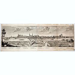
Ingolstadt.
A spectacular panoramic view of Ingolstadt in Bavaria, with legends numbered from A-P and 1-6 in German. With the title in a banderol.After a design by Friedrich Bernhard...
- $1500 / ≈ €1404
Place & Date: Augsburg, 1729
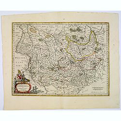
Osnabrugensis episcopatus. . .
A beautiful map of Munster centered on the city of Osnabruck. Prepared by Joannes Michael Gigas (1580-1650+), a doctor, mathematician and geographer. Showing an inset wit...
- $200 / ≈ €187
Place & Date: Amsterdam, 1629-1630
![Map of the Occupied Areas. Carte des Zones d'Occupation. Der Besatzungs-Zonen mit Neuen Postleitgebieten. Karta Okkupacionnych Zon [in Cyrillic.]](/uploads/cache/42060-250x250.jpg)
Map of the Occupied Areas. Carte des Zones d'Occupation. Der Besatzungs-Zonen mit Neuen Postleitgebieten. Karta Okkupacionnych Zon [in Cyrillic.]
A poster map of Germany and Austria showing the Allied occupation zones as agreed at the Potsdam Conference after the end of the Second World War, with an inset detail of...
- $350 / ≈ €328
Place & Date: Frankfurt-am-Maine: Atlanta-Service, 1946
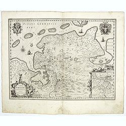
Typus Frisiae Orientalis.
Decorative map of east Frisia in Germany with the Watten islands. With inset map of the area south of Emden. Prepared by Ubbo Emmius (1547-1625). Two very decorative coat...
- $350 / ≈ €328
Place & Date: Amsterdam, 1629-1630
Westfaliae.
A nice map showing the province of Westphalia.Mercator was born in Rupelmonde in Flanders and studied in Louvain under Gemma Frisius, Dutch writer, astronomer and mathema...
- $100 / ≈ €94
Place & Date: Amsterdam, 1630
Archiepiscopatus Maghdeburgensis et Anhaltinus Ducatus.
A very nice, decorative copper engraved map of Lower-Saxony and Saxony-Anhalt by Blaeu. With one figural cartouche. Bounded on the west by the River Wesel between Nienbur...
- $80 / ≈ €75
Place & Date: Amsterdam, 1645
Bamberg in Francken.
A spectacular panoramic view of Bamberg, with legends numbered from 1-24 in German. With the title in a banderol.After a design by Friedrich Bernhard Werner (1690-1776) w...
- $1500 / ≈ €1404
Place & Date: Augsburg, 1729
Heidelberg.
A spectacular panoramic view of Heidelberg, with legends numbered from 1-72 in German. With the title in a banderol.After a design by Friedrich Bernhard Werner (1690-1776...
- $1500 / ≈ €1404
Place & Date: Augsburg, 1729
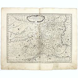
Episcopatus Paderbornensis
Detailed map centered on Paderborn. Prepared by Joannes Michael Gigas (1580-1650+), a doctor, mathematician and geographer who made also maps of Osnabrug, Westphalia, Mun...
- $100 / ≈ €94
Place & Date: Amsterdam, 1629-1630
L'Allemagne divisée en dix cercles . . .
An interesting small map of Germany and Poland by Nicolas de Fer. From his rare "Petit et Nouveau Atlas". The first edition was published in 1697 and was republ...
- $75 / ≈ €70
Place & Date: Paris, 1704